
User:LADave/Sandbox
Watch List[edit]
- Query to Russian editor about biblio. info. for Soviet military topos [2]
- Wikipedia_talk:Naming_conventions_(Cyrillic)#Example_convention
- Talk:Magars
- Soviet mapping will list of mapping institutions be extended from 1941?
- Wikipedia talk:Citing sources#Is it better to be concise or complete?
- Wikipedia_talk:WikiProject_Council#Stupid_newbie_question
- Wikipedia_talk:WikiProject_Geography#Statistical_amassments
- Talk:House_of_Tulsipur
- Talk:Topographic_map#Possible_new_section_on_international_mapping_projects.3F
- Wikipedia_talk:Citation_templates#Need_better_template_for_citing_topographic_maps Try citation discussion page.
- Talk:Himalayas#What_do_you_call_a_discreet_section_of_the_Himalaya.3F
- Wikipedia talk:What Wikipedia is not
- Wikipedia_talk:WikiProject Maps#Need better template for citing topographic maps
- Rolwaling Himal
- Adivasi [3]
- Wikipedia talk:Identifying reliable sources
- Talk:Prithvi Highway#Merge Krishna Bheer here
- Talk:Terai discussion, getting contributions about India
- Talk:Rajput#Nepal_Rajputs.3F
- Talk:Religion in Nepal
sandbox[edit]
Nepali or Hindi नेपालगञ्ज is pronounced [nepaːlɡəndʒ] and transliterated Nepalgunj or Nepalganj.
Sharda River: move to Tourism etc. section. (The area around Pancheshwar is called 'Kali Kumaon'). Kalapaani is situated on the route of Kailash Manasarovar Yatra(Pilgrimage) tour and it is said that it was here that the Great Sage Vyasa meditated and spent his life, thus, giving the valley its name, the Vyasa valley. The river is named after the Goddess Kali whose temple is situated in Kalapaani near the Lipu-Lekh pass at the border between India and Tibet.
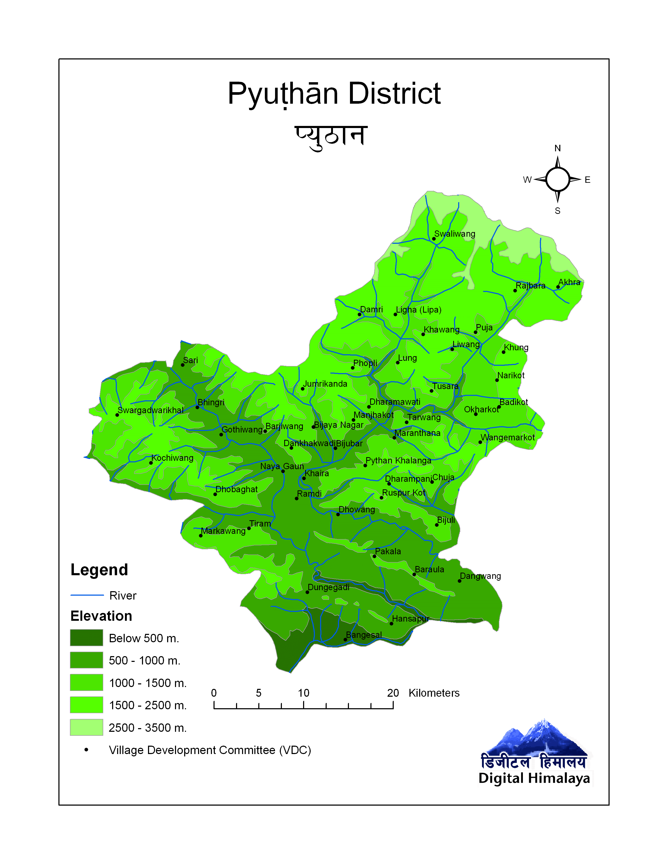
Pyuthan Geography and Climate[edit]
Villages in Arkha VDC[edit]
| Ward | Lat. | Lon | Elev. | ||
|---|---|---|---|---|---|
| Artubang | अर्टुबाङ | 9 | 28°15'N | 83°02'E | 1,625m |
| Banyachaur | बाँयचौर | 28°16'N | 83°04'E | 1,670 | |
| Bas | बास | 28°17'N | 83°04'E | 2,058 |
| Ward | Coordinates | Elev. | ||
|---|---|---|---|---|
| Andherigaun | अँधेरीगाउँ | 28°15′29″N 83°02′35″E / 28.2581°N 83.0430°E | 1570m | |
| Artabang | अर्टबाङ | 9 | 28°15′06″N 83°02′19″E / 28.2517°N 83.0385°E | 1620 |
| Artubang | अर्टुबाङ | 28°14′38″N 83°01′53″E / 28.2439°N 83.0315°E | 1420 | |
| Banyachaur | बाँयचौर | 28°15′59″N 83°04′04″E / 28.2664°N 83.0679°E | 1670 | |
| Bas | बास | 28°16′31″N 83°04′05″E / 28.2752°N 83.0681°E | 2020 | |
| Besiban | बेसीवन | 28°16′00″N 83°03′13″E / 28.2666°N 83.0537°E | 1540 | |
| Bhande Khoriya | भाँडे खोरिया | 28°15′08″N 83°04′08″E / 28.2522°N 83.0688°E | 2020 |
Bordering Districts[edit]
Pyuthan is the easternmost[1] of Rapti Zone's three middle hill districts, with Rolpa and Salyan further west. These three hill districts rise north of Rapti's inner-terai Dang district which has air and road links to India and the rest of Nepal, as well as the Zone's administrative center Tulsipur and largest town Ghorahi. Lumbini Zone's hill districts Arghakhanchi and Gulmi border Pyuthan to the east.
To the north, Pyuthan has little communication with the more mountainous Baglung and Rukum districts since a subalpine lekh -- not yet crossed by motorable roads and snowbound in winter -- intervenes.[2]
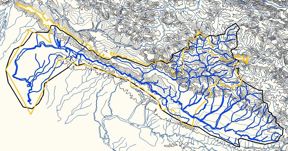
Hydrology[edit]
Upland streams Mardi and Jhimruk Khola(s) and the Rapti River below their conjunction[3] drain Pyuthan. Valley elevations are below 1,000 meters -- in the upper tropical zone -- dropping to 323 metres (1,060 ft) as the Rapti crosses into Dang district and enters Deukhuri Valley.[4] The kilometer-wide floodplain of Jhimruk Khola is the core of Pyuthan district, intensively planted in rice during the summer monsoon and wheat in winter-spring. District center Pyuthan Khalanga overlooks this valley and has shared in its urbanization with the arrival of roads and bus services, electricity, health services, education, communications and merchandising infrastructure. The other, larger upper Rapti tributary -- the Mardi to the west -- has eroded a narrower inner gorge, making it less suited to traditional irrigated agriculture and subsequently slower to urbanize. Some 21 kilometres (13 mi) above the actual confluence, the Jhimruk swings within 1.5 kilometres (1 mi) of the Mardi Khola but some 200 metres (660 ft) higher. Water is diverted down to the Mardi via a tunnel and the 12 Megawatt Jhimruk Hydro-Electric & Rural Electrification Project[5] [6]
Hills and Mountains[edit]
Really two main ranges: Mahabharats on south and to north the Rapti-Gandaki divide lekh with its southward spurs especially Jumrikhanda जुम्रीकाँडा 2,422 metres (7,946 ft) at 28°11′17″N 82°47′42″E / 28.18806°N 82.79500°E
Pyuthan's peaks and ridges begin with the east-west Mahabharat Range (Lesser Himalaya) along Pyuthan's southern border with Dang, a 1,500 metres (4,900 ft) ridge separating the cultures of the Terai and Middle Hills, ending some 45 kilometres (28 mi) north at a 3,000 metres (10,000 ft) east-west lekh dividing the Rapti and Gandaki basins which reaches 3,612 metres (11,850 ft) where Rolpa and Baglung districts meet Pyuthan's Syaulibang VDC.[7]
subalpine lekh that is both Pyuthan's border with Baglung district of Dhaulagiri Zone and the main watershed between the (west) Rapti and Gandaki River basins. Pyuthan's highest elevation 3,612 metres (11,850 ft) stands on this ridge.<ref, coinciding with the meeting point of Pyuthan's Syaulibang VDC, Rolpa's Gaam VDC to the west,and and Baglung's Bowang VDC to the north.</ref>
Rolpa District borders Pyuthan to the west, along a divide between Jhimruk Khola whose valley is the core of Pyuthan and Madi Khola, with Point 3612 the Of the two upper tributaries of the Rapti, Pyuthan contains most of Jhimruk Khola and the lower part of Madi Khola after it exits Rolpa District bordering Pyuthan to the west along the Jimruk-Madi divide south from point 3612. The Madi-Jhimruk confluence is in southern Pyuthan, in the Mahabharat Range.< On the southeast Pyuthan borders Lumbini Zone including Arghakhanchi and Gulmi districts. Pyuthan's lowest elevation 323 metres (1,060 ft) is at the Rangle Khola (right bank) confluence where the Rapti crosses from Pyuthan's BangesalVDC into Dang's Lalmatiya VDC, bordering Arghakhanchi's Juluke VDC on the east bank.Cite error: There are <ref> tags on this page without content in them (see the help page)..
Climate[edit]
| Climate Zone[8] | Elevation Range | % of Area |
|---|---|---|
| Upper Tropical | 323 to 1,000 meters 1,060 to 3,300 ft. |
36.1% |
| Subtropical | 1,000 to 2,000 meters 3,300 to 6,600 ft. |
53.3% |
| Temperate | 2,000 to 3,000 meters 6,400 to 9,800 ft. |
9.7% |
| Subalpine | 3,000 to 3,612 meters 9,800 to 11,850 ft. |
0.8% |
Geography/Climate Footnotes and References[edit]
- ^ Actually Nepal's defining mountain ranges trend about WNW to ESE. For simplicity's sake, cardinal directions used in this article are rotated clockwise so "north" trends slightly east of true north, "east" trends equally south, "south" trends west and "west" trends north.
- ^ relief map
- ^ Mardi and Jimruk Khola(s) join to form Rapti River at 27°55′50″N 82°56′32″E / 27.93056°N 82.94222°E and elevation 391 metres (1,283 ft)
- ^ Rapti crosses from Pyuthan district into Dang at 27°52′39″N 82°48′17″E / 27.87750°N 82.80472°E and elevation 323 metres (1,060 ft).
- ^ "Jhimruk Hydro-Electric & Rural Electrification Project". Himal Hydro & General Construction Ltd. Retrieved January 2, 2014.
- ^ Generating station location 28°04′08″N 82°48′09″E / 28.06889°N 82.80250°E
- ^ 3,612 metres (11,850 ft) summit at 28°21′35″N 82°57′18″E / 28.35972°N 82.95500°E
- ^
The Map of Potential Vegetation of Nepal - a forestry/agroecological/biodiversity classification system (PDF), . Forest & Landscape Development and Environment Series 2-2005 and CFC-TIS Document Series No.110., 2005, ISBN 87-7803-210-9, retrieved Nov 22, 2013
{{citation}}: Check|isbn=value: checksum (help); Unknown parameter|ignore-isbn-error=ignored (|isbn=suggested) (help); horizontal tab character in|series=at position 91 (help)
Demographics[edit]
from Vietnamese WP Dân số =[edit]
Biến động dân số giai đoạn 1952-2001:
| Year | 1952 | 1961 | 1971 | 1981 | 1991 | 2001 |
|---|---|---|---|---|---|---|
| Population | 198138 | 212481 | 137338 | 157669 | 175469 | 212484 |

Population by Census 1971-2011[4][5][edit]
(example for Pyuthan)

- ^ "Districts of Nepal". statoids.com. Retrieved 2012-11-11.
- ^ (in English)"Nepal Census Information Site". Cơ quan Thống kê Nepal. Retrieved 2012-11-11.
- ^ "Population Census 1961 Report". Cơ quan Thống kê Nepal. Retrieved 2012-11-11.
- ^ #"Districts of Nepal". Statoids. Gwillim Law. Retrieved January 23, 2014.
- ^ #National Population and Housing Census 2011, Volume 3 (PDF). Kathmandu, Nepal: Government of Nepal, Central Bureau of Statistics. January 2014. Retrieved January 23, 2014.
Kalapani[edit]
Kalapani, India[edit]
काली माता मन्दिर or मंदिर (Hindi and Nepali) कालोपानी Nepali
Kalapani (Hindi: कालापानी, kālāpānī or Nepali: कालोपानी, kālopānī) refers to the headwater region of the Kali or Mahakali River in Pithoragarh district, Uttarakhand state, India and Darchula District, Nepal. The name comes from the Kali Mother temple (काली माता मन्दिर, kẫlī mātā mandir) at 30°13′19″N 80°54′37″E / 30.22194°N 80.91028°E and 3,600 metres (11,800 ft) elevation. A tank or pond in front of the sanctum is the river's source by tradition. The sage Vyasa is believed to have meditated there, hence the local name Byans valley. The temple is a waystation for Buddhist, Hindu, Jain and even New Age pilgrims traveling to Lake Manasarovar and Mount Kailash in Tibet.
The river's geographic sources are at least a thousand metres higher along the snow line and glacier snouts of Lipu Lekh (Nepali: लिपूलेख, lipūlekh). The border separating Tibet Autonomous Region from India and Nepal follows the crest of this 6,000 metres (20,000 ft) watershed which includes the notable peak Om Parvat and Lipu-Lekh Pass leading into Tibet is 17 kilometers from Kalapaani.
Kalapani Border Dispute 1[edit]
Kalapani (Hindi: कालापानी) is an area under territorial dispute[1][2]
The Kingdom of Nepal was unified by Prithvi Narayan Shah, originally ruler of the small Gorkha principality. He conquered and annexed neighboring hill kingdoms, iincluding Kathmandu by 1769. He and his heirs continued to annex additional petty kingdoms and tribal enclaves east to the Teesta in Sikkim and west to the Sutlej in River|Sutlej]] in Himachal Pradesh. , and , , west to xxx and south to Gorakhpur, some xxx sq km in all. This brought Nepal into conflict with the British expansion, leading to the Anglo-Nepalese war of 18...-... The Gorkhas were underestimated, fought valiantly and achieved early victories but the British committed more resources and prevailed. The 1815 Sugauli Treaty trimmed Nepal to some xxxx sq. km, moving the eastern boundary back xx km to the Mechi, the southern boundary with a few kilometers of the outermost foothills, and the western boundary yy km back to the Kali River in Kumaon. Unfortunately the British did not have a good handle on the geography of the Kumaon mountains and they knew very little about the uppermost tributaries of the Kali.
concluded the Anglo-Nepalese War between the British (what was before the Raj?) and the newly-unified Kingdom of Nepal. After conquering Kathmandu Valley the Shah kings from Gorkha progressively added territory east to the Teesta, west as far as .... and south to Gorakhpur. Nepal had annexed small hill kingdoms as far west as...The victorious British This treaty made the Kali the boundary between British Kumaon and the Gurkha state. The Great Trigonometric Survey of India was some five decades from completion and the exact geography of the Himalaya was not yet well understood, so the treaty's description of the uppermost course of the river was vague. Little was made of this until the 1962 Sino-Indian War suddenly made India's northern border a bone of contention and India became suspicious of Chinese diplomatic and development overtures to Nepal such as building Friendship Highway from Lhasa to Kathmandu in 1967 which was already connected to India by Tribhuvan Highway built with Indian aid.
India's Uttarakhand state to the southwest and Nepal's that is the river's traditional source although the is an area under territorial dispute[1] [3] The origin of Sharda River, it is situated on the Kailash Mansarovar route, at an altitude of 3600 meters. A pool by the temple of the Goddess Kali is considered to be the source of the Kali River. A verdant valley covered with Pine, Bhojpatra and Juniper trees, it offers stunning views of some of the lesser known peaks like Om Parvat in the Central Himalayas.Lipu-Lekh Pass leading into Tibet is 17 kilometers from Kalapaani.
Although claimed by Nepal, Kalapaani is currently being occupied by India's Indo-Tibetan border security forces [3] since the 1962 border war with China. Nepal claims that the river to the west of Kalapani is main Kali, hence it belongs to Nepal. But India claims that river to the east of Kalapani is the main Kali river, hence Kalapani area belongs to India. The river borders the Nepalese zone of Mahakali and the Indian state of Uttarakhand. The Sugauli Treaty signed by Nepal and British India in 1816 locates the Kali River as Nepal's western boundary with India.[3] Subsequent maps drawn by British surveyors show the source of the boundary river at different places. This discrepancy in locating the source of the river led to boundary disputes between India and Nepal, with each country producing maps supporting their own claims. The Kalapani River runs through an area that includes a disputed area of about 400 km² [1] around the source of the river although the exact size of the disputed area varies from source to source.[4]
References[edit]
- ^ a b c "Field Listing - Disputes - international". CIA World Factbook. Retrieved 2007-03-23. Cite error: The named reference "CIA" was defined multiple times with different content (see the help page).
- ^ Cite error: The named reference
findarticleswas invoked but never defined (see the help page). - ^ a b c "Defining Himalayan borders an uphill battle". 2000-01-03. Retrieved 2013-12-19.
- ^ "India's Boundary Disputes with China, Nepal, and Pakistan". International Boundary Consultants website. Retrieved 2013-12-19.
Category:Territorial disputes of Nepal Category:Territorial disputes of India
Kalapani Border Dispute 2[edit]
Although claimed by Nepal, Kalapani is currently occupied by India's Indo-Tibetan border security forces [1] since the 1962 border war with China. Nepal claims that the river to the west of Kalapani is main Kali, hence it belongs to Nepal. India claims that river to the east of Kalapani is the main Kali river, hence Kalapani area belongs to India. The river borders the Nepalese zone of Mahakali and the Indian state of Uttarakhand. The Sugauli Treaty signed by Nepal and British India in 1816 locates the Kali River as Nepal's western boundary with India.[1] Subsequent maps drawn by British surveyors show the source of the boundary river at different places. This discrepancy in locating the source of the river led to boundary disputes between India and Nepal, with each country producing maps supporting their own claims. The Kalapani River runs through an area that includes a disputed area of about 400 km² [2] around the source of the river although the exact size of the disputed area varies from source to source.[3]
References[edit]
- ^ a b "Defining Himalayan borders an uphill battle". FindArticles.com. 2000-01-03. Retrieved 2007-03-23.
- ^ "Field Listing - Disputes - international". CIA World Factbook. Retrieved 2007-03-23.
- ^ "India's Boundary Disputes with China, Nepal, and Pakistan". International Boundary Consultants website. Retrieved 2007-03-23.
Sources[edit]
- Adhikari, Gyanu (June 3, 2013). "Nepal-India agree to find missing border pillars, enhance security". The Hindu. Retrieved 2013-12-22.
- "Transnational Issues: Nepal". CIA World Factbook. Retrieved 2013-12-22. (Click on "Transnational Issues:: NEPAL".)
- Gupta, Alok Kumar (2000-10-17). "Kalapani: A Bone of Contention Between India and Nepal, Nepal Articles #422". Institute of Peace and Conflict Studies (IPCS). New Delhi. Retrieved 2013-12-22.
- "India's Boundary Disputes with China, Nepal, and Pakistan". International Boundary Consultants website. Retrieved 2013-12-22.
- KC (Khatri Chhetri), Sharad (10 Sept. 2004). "Kalapani's New "Line of Control". Nepali Times. Kathmandu. Retrieved 2013-12-22.
{{cite news}}: Check date values in:|date=(help) - Kyodo News International (Jan. 3, 2000). "Defining Himalayan borders an uphill battle". Retrieved 2013-12-22.
{{cite newsgroup}}: Check date values in:|date=(help) - Manandhar, Mangal Siddhi; Koirala, Hriday Lal (June 2001). "Nepal-India Boundary Issue: River Kali as International Boundary". Tribhuvan University Journal. 23 (1): 1–21. Retrieved 2013-12-22.
- Orton, Anna (2000). India's Borderland Disputes: China, Pakistan, Bangladesh and Nepal. New Delhi: Epitome Books. ISBN 978-93-80297-15-6. Retrieved 2013-12-22.
- Pant, Prem Kumari (2009). "Long and Unsolved Indo-Nepal Border Dispute". The Weekly Mirror. Kathmandu. Retrieved 2013-12-22.
- Shrestha, Buddhi Narayan. "Nepal's territory is extended not only to Kalapani, but 17 Kms. west up to Limiyadhura". Telegraphnepal.com. Retrieved December 27, 2013.
- Shrestha, Reagan (December 10, 2005). "Indian Encroachment Threatening Nepal's Sovereignty". News Blaze. Alan Gray. Retrieved December 27, 2013.
- "Pranab says new Indo-Nepal border soon". The Times of India. Nov. 25, 2008. Retrieved 2013-12-22.
{{cite news}}: Check date values in:|date=(help) - "Nepal Revives Border Feud with India". The Times of India. March 17, 2010. Retrieved 2013-12-22.
Tinkar[edit]
Tinkar (Nepali: तिंकर) Refers to a cluster of geographic entities in high mountains of Byash VDC of Darchula District, Mahakali Zone, far western Nepal. They are all situated less than 20 kilometres (12 mi) south of the triple border point of Nepal, Tibet Autonomous Region, China (T.A.R.) and Uttarakhand, India at 30°13′59″N 81°01′42″E / 30.23306°N 81.02833°E.
The area borders the Mahakali River to the west, assigned as Nepal's border with Kumaon India in the Sugauli Treaty of 1815. Edwardian explorer-painter A.H. Savage Landor visited the area in 1897, mentioning it in a report[1] and illustrated travelogue.[2]
Tinkar Khola[edit]
(Nepali: तिंकर खोला, tinkar kholā) is a tributary of the Mahakali River sourced from glaciers and snowfields along the Tibet Autonomous Region border range Lipulekh east of Lipulekh Pass and joining the Mahakali at 30°07′33″N 80°52′22″E / 30.12583°N 80.87278°E a short distance above Garbyang, Uttarakhand.
Tinkar Village[edit]
30°08′08″N 80°59′06″E / 30.13556°N 80.98500°E, 3,720 metres (12,200 ft) elevation. About 8 km. east of Chhangru, the last village in Nepal on the approach to Tinkar Pass. Trades cereals, spices and sugarcane for Tibetan wool and salt.[3]
Tinkar Pass[edit]
Crosses the Lipulekh T.A.R. border range at 30°11′39″N 81°02′24″E / 30.19417°N 81.04000°E and 5,270 metres (17,300 ft) elevation. This is about 4 km. south of easier 5,100 metres (16,700 ft) Lipulekh Pass closed to Nepalese nationals due to a border dispute with India. The approach to Tinker Pass is in undisputed Nepalese territory.
References[edit]
- ^
Landor, H.A. Savage (1898). In the Forbidden Land: an Account of a Journey in Tibet, Capture by the Tibetan Authorities, Imprisonment, Torture, and Ultimate Release. London: William Heinemann. Retrieved Dec. 18, 2013.
{{cite book}}: Check date values in:|accessdate=(help) - ^
Landor, H.A. Savage (1905). Tibet and Nepal, Painted and Described. London: A. & C. Black. Retrieved Dec. 18, 2013.
{{cite book}}: Check date values in:|accessdate=(help) - ^
Chaudhary, Ram P. (supervisor); et al. (June 2010). Kailash Sacred Landscape Conservation Initiative Feasibility Assessment Report - Nepal. Kirtipur, Nepal: Central Department of Botany, Tribhuvan University.
{{cite book}}: Explicit use of et al. in:|first=(help)
Tibet Autonomous Region, China border checkpoints[edit]
These are listed west to east. Third country nationals cross at Tatopani and in guided groups at Yari; other checkpoints are mainly used by traders.
| Crossing Name |
Crossing Location |
Border elevation |
Maximum inside T.A.R. |
Nepal town | District | Zone | Tibet town | County | Prefecture |
|---|---|---|---|---|---|---|---|---|---|
| Tinkar Pass | 30°11′39″N 81°02′24″E / 30.19417°N 81.04000°E | 5,270 m (17,300 ft) | Ghaga | Darchula | Mahakali | Burang | Burang | Ngari | |
| Yari | 30°09′12″N 81°20′00″E / 30.15333°N 81.33333°E | 3,640 m (11,900 ft) | 4,720 m (15,500 ft) | Hilsa | Humla | Karnali | " | " | " |
| Mustang | 29°19′24″N 83°59′09″E / 29.32333°N 83.98583°E | 4,620 m (15,200 ft) | Lo Manthang | Mustang | Dhaulagiri | Zhongba | Zhongba | Shigatse | |
| Rasuwa | 28°16′45″N 85°22′43″E / 28.27917°N 85.37861°E | 1,850 m (6,100 ft) | 5,230 m (17,200 ft) | Dhunche | Rasuwa | Bagmati | Zongga | Gyrong | " |
| Tatopani | 27°58′24″N 85°57′50″E / 27.97333°N 85.96389°E | 1,760 m (5,800 ft) | 5,150 m (16,900 ft) | Kodari | Sindhupalchok | Bagmati | Zhangmu | Nyalam | " |
See also[edit]
References[edit]
Headquarters: Simikot | ||
| Rural municipalities |  | |
List of municipalities and rural municipalities of Nepal | ||
Category:Populated places in Humla District Category:Humla District Category:China–Nepal border crossings
This article about a location in Karnali Province of Nepal is a stub. You can help Wikipedia by expanding it. |
Babai[edit]
| Babai River | |
|---|---|
| Location | |
| Country | Nepal and India |
| Physical characteristics | |
| Source | |
| • location | 27º58'27"N, 82º34'6"E, (eastern end of Dang Valley) |
| • elevation | 672 m (2,205 ft) |
| Mouth | |
• location | 27º44'8"N, 81º17'54" at Ghaghara River NW of Bahraich |
• elevation | 118 m (387 ft) |
| Length | about 250 km. (150 mi.) |
| Basin size | 3,500 km2 (1,400 sq mi) in Nepal, 200 km2 (77 sq mi) in India |
| Discharge | |
| • average | 71 m3/s (2,500 cu ft/s) (4 in April - 588 in July, at Chepang above Sharada confluence) |
| Basin features | |
| Progression | Nepal Mid-West Region: Dang, Salyan, Bardiya districts; India Uttar Pradesh Awadh region: Bahraich district |
| River system | Ganges |
| Tributaries | |
| • right | Sharada Khola |
Notes[edit]
http://www.ub.uib.no/elpub/NORAD/2002/ntnu/thesis01.pdf Shyam Kishor Yadav. M.Sc. Thesis on Hydrological Analysis of Bheri-Babai Hydropower Project-Nepal. June 2002 . Norwegian University of Science and Technology, Department of Hydraulic and Environmental Engineering. About project to divert water from Bheri through 12.7 km tunnel to Babai at Chepang and generate 48 MW.
PP 4-5: Bheri is himalayan river. Averages 396 m^3/s at intake site. Monthly averages range from 44 to 3132 m^3/s. Diversion site is ~60 km upstream of Jamu (Jamu is gauging station 5 km above Bheri-Karnali confluence). Bheri catchment is 11255 km^2 at dam site and 13870 km^2 at Karnali confluence. "Babai River Basin", pp 5 ff. Catchment is 2602 km^2 at project outlet. Avg. discharge at outlet is 71 m^3. Monthly averages range from 4 to 588 m^3/s.
Narendra Man Shakya, "Water Resources in Nepal"
http://www.tribhuvan-university.edu.np/Tu%20Bulletin%20Special%202011-2012/74-85.pdf
Tribhuvan U. Special Bulletin 2068 (2012) Babai length in Nepal is 190 km. Catchment is 3270 sq km.
(according to catchment map http://awsassets.panda.org/img/river_basin1_368588.jpg there is another river between Rapti and Babai even inside Nepal.}
simple map of all river basins in Nepal http://raonline.ch/pages/np/npmaps01i.html
Highly detailed map, article: http://www.sabo-int.org/projects/nepal.html
Hannah, David M., Sunil R. Kansakar, A.J. Gerrard, Gwyn Rees (2005) "Flow regimes of Himalayan rivers of Nepal: nature and spatial patterns", Journal of Hydrology 308, pp. 18-32. http://startinternational.org/library/archive/files/flow_regimes_himalayan_rivers_nepal_jhydrol_2005_a7bc6318e2.pdf - river basin map p. 21 - precipitation map p. 28
Dipak Gyawali (1989) "Water in Nepal, An Interdisciplinary Look at Resource Uncertainties, Evolving Problems, and Future Prospects", Occasional Papers of the East-West Environmental and Policy Institute. Paper No. 8 - Ganges-Bhrahmaputra basin p. 18 - Nepal river basin map p. 27 - schematic diagram p. 30
http://bbdmp.gov.np/ - official website of Bheri-Babai diversion project
stone-age artifacts on Babai
http://www.quartaer.eu/pdfs/1991/1991_08_corvinus.pdf
Gudrun Corvinus, "A handaxe assemblage from western Nepal" http://www.assemblage.group.shef.ac.uk/issue7/chauhan.html handaxes and other artefacts dated to early paleolithic, earlier than expected. Found in alluvial deposits on the Babai, in Dang Valley (as well as Mahottari District in eastern Nepal), about 10 km. SSE of Ghorahi. Some 18 sites along the Babai
Intro[edit]
Babai River (Nepali: बबई नदी, babaī nadī) is a transboundary river draining a southern part of Nepal's Mid-Western Development Region in Dang, Salyan and Bardiya districts. The Babai first flows west some 125 kilometres (80 mi) along the axis of the confining Siwalik Hills, then some 80 kilometres (50 mi) south across the Terai into into Bahraich District, Uttar Pradesh, India where it joins the Karnali/Ghaghra, a major himalayan tributary to the Ganges.
In contrast to the Karnali and Nepal's other large, glacier-fed river systems, the Babai has a smaller basin in the southern part of the country where elevations range between 200 to 2,000 metres (700 to 6,600 ft) and tropical to sub-tropical climates prevail.[1]. Without buffering snow accumulation, streamflow drops to very low levels during the dry, hot Spring but increases dramatically during the Summer monsoon.
River Basin[edit]
The catchment begins in Dang Valley, a 50 by 15 km. (30 x 10 mi.) Inner Terai valley in Dang Deukhuri District. This valley lies between the Mahabharat Range to the north and Siwalik Hills to the south. Beyond both ranges it is enclosed by the basin of the Rapti except along the valley's outlet to the northwest. There the Babai catchment consists of two to three parallel valleys trending WNW along the axis of the Siwalik Hills into Salyan district. The Sharada Khola sub-basin connects from the north via a connecting gorge across the Mahabharat Range and two ridges of Siwaliks. It drains about half of Salyan's section of the Middle Hills.
Beyond the Sharada confluence the Bheri basin borders to the northwest while the Babai catchment remains confined in the Siwaliks. Then the hills fall away and open Terai plains in Bardiya District ensue. Now the catchment becomes ill-defined. Rivers have a history of meandering across the broad alluvial plain, making and un-making connections as distributaries form, persist for decades or centuries, but ultimately fill up with sediment and are abandoned. The Babai's present catchment crosses the international border into Bahraich District, Uttar Pradesh and tapers to a confluence with the Karnali/Ghaghara northwest of Bahraich. Sometime in the future the Babai could redirect itself west to join the Karnali inside Nepal, or it might turn east to join the Rapti.
Course[edit]
Babai River rises at the eastern end of Dang Valley at 672 metres (2,205 ft) elevation and meanders 50 kilometres (30 mi) west along its southern edge as seasonal tributaries enter left (L) from the 100 metre (300 ft.) rise of the Dang Range (Siwaliks) and more permanent streams (R) drain the thousand meter (3,000 ft.) escarpment of the Mahabharat Range and it's extensive alluvial apron. At the west end of the valley a new Siwalik sub-range rises out of the earth, confining the stream to an enclosed, forested valley along the WNW axis of these hills and crossing from Dang district into Salyan.
Some 22 kilometres (14 mi) (straight-line) beyond the district boundary the Babai has descended to 400 metres (1,300 ft) and receives Sharada Khola (R). This tributary drains half of Salyan's Middle Hills before cutting through the Mahabharats and the northernmost ridge of Siwaliks. After a further 28 kilometres (17 mi) the Babai enters Bardiya National Park where the enclosing valley begins to open out and the river course bends west, breaking through the final Siwalik ridges, crossing east-west Mahendra Highway and entering open Outer Terai plains at 200 metres (660 ft) elevation, soon leaving Bardiya Park.
The Babai turns south, meandering down the trend of the plains. It reaches the international border 28 kilometres (17 mi) south of the highway crossing. Crossing into Bahraich District of Uttar Pradesh state, the Babai continues another 50 kilometres (30 mi) to its (L) confluence with the Ghaghara/Karnali some 35 kilometres (22 mi) NW of Bahraich at 118 metres (387 ft) elevation. About 10 kilometres (6 mi) further downriver the Sharda/Mahakali also joins (R).
National Parks and Tourism[edit]
Mahseer fishing (park protects against intense fishing pressure: nets, poison, dynamite, electroshocking)
Development[edit]
History[edit]
References[edit]
- ^ reference climate zones
See also[edit]
- "Babai catchment in Nepal" (Map). 1:250,000. Cartography by Babai River Training Works http://4.bp.blogspot.com/-rU8C4to0UzA/T6zuXRRdlMI/AAAAAAAAAA4/oE1PEroFwys/s1600/Babai-Catchment.jpg. Retrieved Nov. 27, 2013.
{{cite map}}: Check date values in:|accessdate=(help); External link in|cartography=|title=(help) - List of rivers of Nepal
Hydrography of Nepal | ||||||||||||
|---|---|---|---|---|---|---|---|---|---|---|---|---|
| Rivers |
| |||||||||||
| Lakes | ||||||||||||
| Glaciers | ||||||||||||
| Icefalls | ||||||||||||
| Dams, barrages | ||||||||||||
| Related topics | ||||||||||||
Category:Rivers of Nepal Category:Hydroelectric power stations in Nepal Category:Rivers of Uttar Pradesh Category:International rivers of Asia
Editing[edit]
General[edit]
- Index to all Help material Help:Contents
- Get help - Ask question on talk page with {{Help me}}
- Cheatsheet Wikipedia:Cheatsheet
- User:Student7 has many useful links
- Wikipedia:Wikipedia essays - essays on how to be a valued WP contributor
- Markup language Help:Wiki_markup
- Editing guidelines Wikipedia:How to edit a page
- Hard Spaces & n b s p ;
- Formatting
- {{clear]] completes all images etc. before starting anything else.
- column templates
- mapping
- Lat/Lon degrees º
- Syntax reference for {{coord|...}} templates: Template:Coord/doc
- coordinates can be entered decimal: |dd.xxxx|N|ddd.xxxx|E| or DMS: |dd|mm|ss|N|dd|mm|ss|E|
- |format=dec converts DMS to decimal. |format=dms converts decimal to DMS.
- |scale:x (1:x) specifies scale of displayed (google/open street) maps.
- |display=inline/title/inline,title controls displayed location of coordinate info.
- coordinates can be entered decimal: |dd.xxxx|N|ddd.xxxx|E| or DMS: |dd|mm|ss|N|dd|mm|ss|E|
- Unit Conversion Template:Convert
- single number
- {{convert|300|m|ft|1|sp=us}} 300 meters (984.3 ft)
- {{convert|300|m|ft|0|sp=us}} 300 meters (984 ft)
- {{convert|300|m|ft|-1|sp=us}} 300 meters (980 ft)
- {{convert|300|m|ft|-2|sp=us}} 300 meters (1,000 ft)
- range of 2 numbers
- {{convert|300|to|1000|m|ft|-1|sp=us}} 300 to 1,000 meters (980 to 3,280 ft)
- Spelling
- {{convert|300|m|ft|1}} 300 metres (984.3 ft)
- {{convert|300|m|ft|1|sp=us}} {{convert|300|m|ft|1|sp=us}
- Abbreviation
- {{convert|100|mm|in|0|sp=us}} 100 millimeters (4 in)
- {{convert|100|mm|in|0|sp=us|abbr=on}} 100 mm (4 in)
- {{convert|100|mm|in|0|sp=us|abbr=off}} 100 millimeters (4 inches)
- {{convert|100|mm|in|0|sp=us|abbr=in}} 100 mm (4 inches)
- {{convert|100|mm|in|0|sp=us|abbr=out}} 100 millimeters (4 in)
- single number
- Magic Words and shortcuts Help:Magic words
- <nowiki>stuff</nowiki> don't process wiki markup, show as written
- Help:Merging
- Wikipedia:Moving a page
- Help:Redirect Wikipedia:Redirect
- #REDIRECT [[article name]] or #REDIRECT [[article name#Section title]]
- Disambiguation
- Help:Disambiguation
- Wikipedia:Disambiguation
- Wikipedia:Manual of Style (disambiguation pages)
- Wikipedia:Hatnote
- Wikipedia:Template_messages_for_disambiguation_and_redirection#Disambiguation_and_redirection
- Using Images Wikipedia:Extended image syntax
- Linking
- to articles across languages: Help:Wiki_markup#Link to the same article in another language
- to another Wiki (e.g. dictionary definitions including other languages): Help:Wiki_markup#InterWiki link
- URL (usually) outside WikiMedia: Help:Wiki_markup#External links - shows how to finesse Wiki-problematic characters including []
- main article: {{Main|Geography of the United States}}
- multiple: {{Main|Geography of the United States|Climate of the United States|Environment of the United States}}
- {{ Lorem ipsum }} add lengthy paragraph of latin for testing, formatting, etc.
- {{ Special characters }} - inform readers that they will see krakozyabry w/o proper fonts
- Wikipedia:Picture tutorial - tutorial on adding pictures/graphics
Citing and Footnotes[edit]
- Help:Footnotes
- Wikipedia:Citing sources
- what information to include
- avoiding citation overkill, bundling multiple cites etc.
- templates: Citation templates for general guidance.
- More specific: Citation; Book, Conference, Court case, Encyclopedia, Episode (TV or Radio), Journal, Map, Newspaper article, News syndicate, Press release, Film or video, Webpage
- separate references by article sections {{reflist|close=1}}
- short citations
- op. cit. etc.
- {{Cite journal | title = Egbert Eidher, 1964 ''op. cit.'' | url = http://www.himalayanclub.org/journal/the-1963-austrian-dhaula-himal-expedition/ }} yields:
- "Egbert Eidher, 1964 op. cit.".
{{cite journal}}: Cite journal requires|journal=(help)- (Note that first ' ' undoes normal italicization of title because we want to italicize op. cit..)
- Maps and DEM data
- Ohio Wesleyan U. suggestions [4]
- North Carolina State U. & several other universities [5]
- WP template to cite USGS topos served by (free) TopoQuest Map Viewer Template:Cite topoquest/doc
- citing SRTM DEM data according to U. of Maryland: [6]
Map Service Infobox[edit]
Projects[edit]
Templates[edit]
- Help:Template - general guide
- Wikipedia:Template namespace - template policies
- Template:Other uses This page is about X. For Y see....
- Wikipedia:Template messages/Redirect pages - very detailed redirect messages
- Infoboxes
- Help:Infobox - background
- index to infoboxes [7]
- Geographical
- Template:Google maps, Template:Yahoo maps, Template:Bing maps
- Template:Infobox settlement
- | coordinates_type = scale:nnnn_AddMoreParms_StillMore...(passes 1+ parms to {{coord}} template); see General|mapping|{{coord... above)
- | coordinates_display = inline,title controls where lat/lon displays
- Template:Infobox river
| Name of River | |
|---|---|
| image_alt image caption | |
| map_alt map_caption | |
| Etymology | river etymology |
| Location | |
| Country | basin_countries |
| Physical characteristics | |
| Source | |
| • location | river origin text |
| • elevation | 1,000 m (3,300 ft) |
| Mouth | |
• location | river mouth text |
• elevation | 10 m (33 ft) |
| Length | 1,000 km (620 mi) |
| Basin size | 10,000 km2 (3,900 sq mi) |
| Discharge | |
| • average | 100 m3/s (3,500 cu ft/s) |
| Basin features | |
| Progression | course progression |
| River system | system |
| Tributaries | |
| • left | list left bank tribs |
| • right | list right bank tribs |
| extra title | extra info |
- Template:Infobox lake
- Template:Nepal topics - Infobox for Nepal regions, counties and cities; placed at the bottom of article pages. not yet finished.
- Template:Infobox ethnic group - generic infobox for an ethnic group. see Kandu
- Template:Infobox mountain
- Template:Infobox mountain pass
- Template:Climate chart
- Template:Geobox/type - links to various geoboxes: mountain range, river, nature preserve, etc.
- Template:Geobox/type/range - a mountain range
- Template:Geobox/type/valley - a valley
- Template:Geobox/type/nature - a nature preserve
- Template:Geobox/type/settlement - a city, town or village
- Help:Designing infoboxes - tutorial
- Template:Infobox - starting point for designing an infobox template
- Wikipedia:Template messages
- Wikipedia:Template messages/General - disambiguation, linking to closely related articles, footnotes and references, fixing incorrect capitalization
- Wikipedia:Template messages/Links - how to link to (mainly) Wikimedia stuff w/o doing full citation
- Wikipedia:Template messages/Maintenance article being worked on. Do not disturb, feel free, etc.; protection messages
- Wikipedia:Template messages/Lists - navigation aids for muli-page lists
- Wikipedia:Template messages/Standard boxes - calendars, tree lists
- Wikipedia:Template messages/Format - colored text boxes, wrapping text inside boxes or anywhere else
Nasty Editor Tools[edit]
- What Wikipedia is not
- Nominating article for deletion
- background - Wikipedia:Proposed deletion
- mark article itself - {{subst:Proposed deletion|concern=reason for proposed deletion}}
- Notify significant contributors:
- Go to their talk page, start new section
- paste in {{subst:Proposed deletion notify|name of article}}
- sign with ~~~~
- {{Pbneutral}}: - politely ask everyone editing this article to use neutral language
- Templates
- Wikipedia:Template messages overview
- Wikipedia:Template messages/Cleanup templates for flagging wide range of issues
- Wikipedia:Template messages/Sources of articles - mark stuff that isn't properly ref'd
- Wikipedia:Template messages/Deletion - deletion of articles, images used w/o permission, etc.
- Wikipedia:Template messages/Disputes - notes for attention of patrolling editors. For serious stuff, e.g. possible deletion
- Wikipedia:Template messages/Lists - needs a list, list should be changed to text
- Wikipedia:Template messages/General - timing (anachronism...)
- Wikipedia:Template messages/Maintenance - flagging copyright violations
- Get list of someone's contributions:
Tools for dealing with edit disputes[edit]
- Wikipedia:Tag team
- Wikipedia:BOLD, revert, discuss cycle
- Wikipedia:Requests for comment
- Wikipedia:Dispute resolution
- Wikipedia:Arbitration
- Wikipedia:Alternative outlets
Foreign Languages[edit]
- Handy stuff
- श्रृंखला - (mountain) range
- Ā ā Ī ī Ū ū
Wikipedias:
Scripts and Transliteration (synopsis)
- {{ Special characters }} - creates box on right:
- Similar infoboxes for Indic scripts, Tibetan, Cyrillic, etc. are shown:
Language templates:
- List of ISO 639-1 codes - for use in {{lang-xx|...
- Template:Lang
- Language Infobox
- Template:Infobox ethnic group
First time you use a language in an article, identify it
- Russian ([[Russian language|Russian]]: {{lang|ru|Москва́}}, {{transl|ru|''Moskva''}}) shows (Russian: Москва́, Moskva)
- Nepali ([[Nepali language|Nepali]]: {{lang|ne|तामाङ}}, {{transl|ne|''tāmāng''}}) shows (Nepali: तामाङ, tāmāng)
- Hindi ([[Hindi language (Hindi belt)|Hindi]]: {{lang|hi|भारत}}, {{transl|hi|''bhārat''}}) shows (Hindi: भारत, bhārat)
- Urdu ([[Urdu language|Urdu]]: {{lang|ur|ترائی}}, {{transl|ur|''tarāī''}}) shows (Urdu: ترائی, tarāī)
- Sanskrit ([[Sanskrit language|Sanskrit]]: {{lang|sa|संस्कृत}}, {{transl|sa|''sanskrit''}}) shows (Sanskrit: संस्कृत, samskrit)
- Spanish ([[Spanish language|Spanish]]: {{lang|es|Español}}, {{transl|es|''espanyol''}}) shows (Spanish: Español, espanyol)
- French ([[French language|French]]: {{lang|fr|Français}}, {{transl|fr|''fransay''}}) shows (French: Français, fransay)
- German ([[German language|German]]: {{lang|de|eßen}}, {{transl|de|''essen''}}) shows (German: eßen, essen)
- Multiple ''adivasi'' ({{lang-sa|}} {{lang-ne|}} {{lang-hi|अदिवासी}}; {{lang|hi-Latn|adivāsī}}) shows
adivasi ([] Error: {{Lang-xx}}: no text (help) [] Error: {{Lang-xx}}: no text (help) Hindi: अदिवासी; adivāsī)
Transliteration
- IAST system for formal transliteration including accented letters
- ({{IAST|jagannātha}}) = (jagannātha)
देवनागरी
International Alphabet of Sanskrit Transliteration (IAST)[edit]
| अ a A |
आ ā Ā |
इ i I |
ई ī Ī |
उ u U |
ऊ ū Ū |
ऋ ṛ Ṛ |
ॠ ṝ Ṝ |
ऌ ḷ Ḷ |
ॡ ḹ Ḹ |
ए e E |
ऐ ai Ai |
ओ o O |
औ au Au |
अं ṃ Ṃ |
अः ḥ Ḥ |
| क k K |
ख kh Kh |
ग g G |
घ gh Gh |
ङ ṅ Ṅ |
| च c C |
छ ch Ch |
ज j J |
झ jh Jh |
ञ ñ Ñ |
| ट ṭ Ṭ |
ठ ṭh Ṭh |
ड ḍ Ḍ |
ढ ḍh Ḍh |
ण ṇ Ṇ |
| त t T |
थ th Th |
द d D |
ध dh Dh |
न n N |
| प p P |
फ ph Ph |
ब b B |
भ bh Bh |
म m M |
| य y Y |
र r R |
ल l L |
व v V | |
| श ś Ś |
ष ṣ Ṣ |
स s S |
ह h H | |
| क्+ष=क्ष kṣa Kṣa |
त्+र=त्र tra Tra |
ज्+ञ=ज्ञ jña Jña |
श्+र=श्र śra Śra |
- Combined consonants: Devanagari#Conjuncts
- Virama in Sanskrit, Halant in Hindi. Drops inherent अ.
Nepal Geography and Census Resources[edit]
- Central Bureau of Statistics [8]
- National Geographic Information Infrastructure Programme [9]
- Digital Himalaya maps, census data, journal archives [10]
- district maps showing VDC boundaries, water features, roads [11]
- Photos of mountains [12]
To Do list[edit]
- Merge Siwalik region into Sivalik Hills. Get better picture instead of the one that's really the Mahabharats.
- rename Lower Himalayan Range to Lesser..., then merge Mahabharat Range into it.
- Kailash/Manasarovar region and sources of Indus, Karnali, Sutlej and Yarlung Tsangpo
- mythical sources all Lake Manasarovear
- traditional sources
- geographical sources & show link to rationale at River source
- Koshi River
- Merge Saptakoshi River and Sapt Koshi into Koshi River (proposed 5/10/2010)
- Merge Koshi Barrage into Kosi embankment (proposed 5/10/2010)
- Deal with Koshi(Nepali)/Kosi (Hindi) ambiguity and inconsistency
- "Tamur" apparently comes from word for "copper", just as "Sunkoshi" is from "gold"
- more on upper tributaries
- Indrawati has Malemchi tributary - westernmost
- check Sun Kosi article. It has a Tibetan name above Kodari, then Bhote Kosi, then Sun Kosi below confluence with Indrawati. Add some detail to main Koshi article too.
- Balephi Khola joins Bhote (Sun) Koshi
- another Bhote Koshi is tributary to Tama Koshi. It is called Rongshar Chu in Tibet and was a trade route to Tingri, more direct than Kodari route.
- Khimti tributary
- Could write lots more on Arun/Bum-Chu
- caste, ethnicity
- Bahuns
- Brahman-Hill into Bahun or vice-versa. Under discussion as of 5/11.
- Bramins of Nepal Started process 5/14.
- Brahman-Hill into Bahun or vice-versa. Under discussion as of 5/11.
- List_of_most_common_surnames_in_Asia#Nepal lists castes rather than names. Started discussion 5/14.
- Ethnicity and caste in Nepal and Nepalese caste system. Merge proposed 5/14.
- Chhetri article needs work
- Merge parallel Ethnicity and caste in Nepal and Nepalese caste system ?
- either add to Adivasi अदिवासी article (currently only covers India) or start separate Janajati जनजाति article.
- Bahuns
- Pyuthan/Rapti
- write article on Babai river
- geocode and map cultural/historical sites. Different (custom) markers for different classes: kot or other historic govt., temple etc.
- illustrate Pyuthan and the rest of Rapti Zone with photos
- compile and summarize school data for Pyuthan district
- link add link to Paddy field to Pyuthan district article.
- Add material from Pyuthan article in Nepali Wikipedia.
- Place names from Kham or Magarkura. Michael Witzel, "Nepalese Hydronomy: Towards a History of Settlement in the Himalayas", Harvard University, 1991. http://www.people.fas.harvard.edu/~witzel/hydro.pdf] (I downloaded it.)
- Maps
- improve mapping, possibly non-static Google maps with key to (multiple) markers onscreen
- add boundaries to Google maps so terrain maps with boundaries can replace outline maps
- Get Nepal district, VDC boundaries
- add maps to other articles: hilltowns, white mountains, nevada mountains (likewise for WikiTravel)
- language
- add more devanagari
- History
- link to this map: [13]
- Harka Gurung () "Late 18th century Gorkhali expansion", included in Mark Turin, "Harka's maps", Nepali Times, Issue #333 (26 January 2007). [14] access date 5/21/2010
- List of mountains in Nepal and List_of_Nepal-related_topics#Mountains_of_Nepal - work in progress using "Mt. Peaks in Nepal" by GON, Ministry of Tourism & Civil Aviation and Rajesh B. Shrestha , "Peaks of the Himalayas".
- Useful refs:
- [15] lists about 30 peaks
- [16] look up peaks, whether and when climbed (can list multiple expeditions). Seems to be comprehensive
- [17] list by Rajesh B. Shrestha
- List of highest mountains - especially satellite image below showing gaps:

- How about a prominence-driven list? Include peaks outside Great Himalaya. At 300m prominence there are even qualifiers in the Siwaliks.
- Useful refs:
- Himalaya article
- Check out listed passes in India. Is a pass through the Siwaliks notable?
- Other historic passes in Nepal - see [18]
- also goes with prominence issue. Passes separating ranges are noteworthy.
.png)
![[13]](http://www.nepalitimes.com/cms/ib/data/1/44/11023.jpg)
- Meru article needs work. No mention of Kailash/Manasarovar region.
- highway articles (Mahendra, Tribhuvan, Arniko etc.) can be improved with official distance data:
[19] Also see Highways.XLS
- Mojibake article - see discussion. Refer individual articles on KOI7, KOI8-R, KOI8-U, CP866, CP1251, Unicode Cyrillic to this. It should also link to [20]. The articles mentioned above should link to the Cyrillic section under Mojibake, and to the utility program in the previous sentence.
- expand Hill Region into longer article. Rename to "Middle Hills"? Link to it instead of re-explaining concept in various articles.
Rivers[edit]
Babai[edit]
http://www.bbdmp.gov.np/ Government of Nepal, Ministry of Irrigation, Department of Irrigation Bheri Babai Diversion Multipurpose Project Bheri Babai Diversion Multipurpose Project (BBDMP) is a multipurpose project aimed to divert 40 m3/s of water from Bheri river to Babai river to irrigate 60,000 Ha agricultural land in Bardiya and Banke districts of Nepal and also to generate about 400 GWH hydroelectric energy annually.
Main work under the contract includes construction of a 12 Km long Head Race Tunnel with about 4.2 m finished diameter. The tunnel shall be constructed using a suitable type of Tunnel Boring Machine (TBM) and lined with precast concrete segments.
The tunnel alignment lies in Surkhet and Bardia districts of Mid Western Development region of Nepal. Inlet portal of the tunnel lies in Ramghat VDC of Surkhet district, outlet portal lies in Belwa VDC of Bardiya District and almost all part of the tunnel lies within Surkhet District.
The project area is about 560 Km from Kathmandu and is accessible by all weather black topped highway. Only about 2.5 km access road needs to be constructed to access the construction site from the highway.
http://www.ub.uib.no/elpub/NORAD/2002/ntnu/thesis01.pdf
Shyam Kishor Yadav. M.Sc. Thesis on Hydrological Analysis of Bheri-Babai Hydropower Project-Nepal. June 2002 . Norwegian University of Science and Technology, Department of Hydraulic and Environmental Engineering.
- About project to divert water from Bheri through 12.7 km tunnel to Babai at Chepang and generate 48 MW.
- PP 4-5: Bheri is himalayan river. Averages 396 m^3/s at intake site. Monthly averages range from 44 to 3132 m^3/s. Diversion site is ~60 km upstream of Jamu (Jamu is gauging station 5 km above Bheri-Karnali confluence). Bheri catchment is 11255 km^2 at dam site and 13870 km^2 at Karnali confluence.
- "Babai River Basin", pp 5 ff. Catchment is 2602 km^2 at project outlet. Avg. discharge at outlet is 71 m^3. Monthly averages range from 4 to 588 m^3/s.
Narendra Man Shakya, "Water Resources in Nepal" http://www.tribhuvan-university.edu.np/Tu%20Bulletin%20Special%202011-2012/74-85.pdf Tribhuvan U. Special Bulletin 2068 (2012) Babai length in Nepal is 190 km. Catchment is 3270 sq km.
(according to catchment map http://awsassets.panda.org/img/river_basin1_368588.jpg there is another river between Rapti and Babai even inside Nepal.}
simple map of all river basins in Nepal http://raonline.ch/pages/np/npmaps01i.html
Highly detailed map showing adjuncts in Tibet and India, article: http://www.sabo-int.org/projects/nepal.html
Hannah, David M., Sunil R. Kansakar, A.J. Gerrard, Gwyn Rees (2005) "Flow regimes of Himalayan rivers of Nepal: nature and spatial patterns", Journal of Hydrology 308, pp. 18-32. http://startinternational.org/library/archive/files/flow_regimes_himalayan_rivers_nepal_jhydrol_2005_a7bc6318e2.pdf
- river basin map p. 21
- precipitation map p. 28
Dipak Gyawali (1989) "Water in Nepal, An Interdisciplinary Look at Resource Uncertainties, Evolving Problems, and Future Prospects", Occasional Papers of the East-West Environmental and Policy Institute. Paper No. 8
- Ganges-Bhrahmaputra basin p. 18
- Nepal river basin map p. 27
- schematic diagram p. 30
Bheri-Babai water diversion[edit]
This planned project[1] will divert 40 cubic metres (1,400 cu ft) per second from the Bheri to the Babai via a 4.2 metres (13.8 ft) tunnel 12 kilometres (7 mi) long. The intake from the Bheri will be in in Ramghat VDC of Surkhet district at xxdyy'N, xxdyy'E and the outlet to the Babai will be in Belwa VDC of Bardiya District at xxdyy'N, xxdyy'E. The water will be used to irrigate 60,000 hectares (148,000 acres) and generate about 400 GWH annually.
- ^
Bheri Babai Diversion Multipurpose Project, Nepal, Ministry of Irrigation, retrieved Dec. 3, 2013
{{citation}}: Check date values in:|accessdate=(help)
Ghaghara[edit]
Another important tributary of Ghaghara in India is the Sarayu river, famous for the location of Ayodhya, the capital of Dasarath’s Kingdom.
Sarayu river is stated to be synonymous with the modern Ghaghara river or as a tributary of it
"The Ghaghra forms the southern boundary of the district, from its entry opposite the sacred town of Ayodhya, where for a short distance it is usually known as the Saryu, as far as Belghat on the border of Gorakhpur." River Sarayu which features in the epic Ramayana is often believed to be synonymous with the modern Ghaghara river or as its tributary. Sarayu is said to have played a vital role for city and life of Ayodhya. Lord Rama is believed to have immersed himself in the Sarayu to return to his eternal, real Mahavishnu form. Hindus consider a holy dip in the Sarayu river as very auspicious. River Sarayu which features in the epic Ramayana is often believed to be synonymous with the modern Ghaghara river or as its tributary. Sarayu is said to have played a vital role for city and life of Ayodhya. Lord Rama is believed to have immersed himself in the Sarayu to return to his eternal, real Mahavishnu form. Hindus consider a holy dip in the Sarayu river as very auspicious.
River Sarayu which features in the epic Ramayana is often believed to be synonymous with the modern Ghaghara river or as its tributary. Sarayu is said to have played a vital role for city and life of Ayodhya. Lord Rama is believed to have immersed himself in the Sarayu to return to his eternal, real Mahavishnu form. Hindus consider a holy dip in the Sarayu river as very auspicious.
"Ghagra enters India at Katarniaghat. Tribs: Sharda, Rapti, Little Gandak.
Bagmati joins Kosi in India.
Suheli/Babai (left) joins first at 27d44'N, 81d17'E ) , then Sharda/Kali/Mahakali (right) at 27d41'N, 81d17E), both about 35 km wnw of Bahraich. Ancient city Ayodhyaat 26d48N, 82d12'E is on right bank downstream 6km east of Faizabad. Kuwana R. flows through Basti, Uttar Pradesh and joins (left) at 26d23N, 83d14E. Rapti joins (left) at Kaparwaa Ghat about 17 km east of Barhalganj. (26d17'N, 83d40'E). Little (Chhoti) Gandak (left) joins Ghaghara at the border between Deoria district, U.P. and Siwan district, Bihar (26d09'N, 84d02'E). Ghaghara joins Ganges River at 25d45'N, 84d40E, 7 km. SW of Chhapra, Bihar. This is only 53km west of the Ganges-Gandaki confluence at 25d39'N, 84d11'E near Patna, Bihar. Note Mohana R. is right-bank river rising in Nepal Siwaliks near Dhangardi. Part of Dhangardi basin per Dipak Gyawali's "Water in Nepal"
The east bank Babai River (Suheli in India) and west bank Mahakali (Kali or Sharda in India) join about 34 km. WNW of Bahraich, U.P.. modern Faizabad U.P. and historic Ayodhya are passed on the right bank. The left bank Rapti joins at Kaparwaa Ghat (26d17'N, 83d40'E) about 17 km east of Barhalganj. )plus and Little Gandak. The Ghaghara flows southeast through Uttar Pradesh and Bihar states to join the Ganges downstream of the town of Chhapra, after a course of 1080 km.
Wikipedia: Infobox items |source_name = Mapchachungo Glacier |source_location = Tibet |source_country = China |source_country1 = |source_elevation = 3962 |tributary_left = Bheri |tributary_left1 = Sarju note: alt. name for Ghaghara near Ayodhya |tributary_left2 = Kuwana River |tributary_left3 = Rapti |tributary_left4 = Little Gandak |tributary_right = Seti |tributary_right1 = Dahawar note: alt. name for Sarda |tributary_right2 = Sarda
Karnali or Ghaghara (Nepali: कर्णाली Karṇālī [kʌrˈnɑːliː]; Hindi: घाघरा Ghāghrā [ˈɡʱɑːɡrɑː]) is a perennial trans-boundary river originating on the Tibetan Plateau near Lake Mansarovar. It cuts through the Himalayas in Nepal and joins the Sarda River at Brahmaghat in India. Together they form the Ghaghra River, a major left bank tributary of the Ganges. With a length of 507 kilometres (315 mi) it is the largest river in Nepal. The total length of Ghaghara River up to its confluence with the Ganges at Doriganj in Bihar is 1,080 kilometres (670 mi).[1] It is the largest tributary of the Ganges by volume and the second longest tributary of the Ganges by length after Yamuna.
In Chinese it is called K'ung-ch'iao Ho, in Nepali it is called Kauriala and Karnali. It is also spelled Gogra, Ghaghra, Ghagra, or Ghāghara.[2]
River course[edit]


It rises in the southern slopes of the Himalayas in Tibet, in the glaciers of Mapchachungo, at an altitude of about 3962 metres (13,000 ft) above sea level. The river flows south through one of the most remote and least explored areas of Nepal as the Karnali River. The 202 km Seti River drains the western part of the catchment and joins the Karnali River in Doti District north of Dundras hill. Another tributary the 264 km long Bheri rises in the western part of Dhaulagiri Himalaya and drains the eastern part of the catchment, meeting the Karnali near Kuineghat in Surkhet.[3]
Cutting southward across the Siwalik Hills, it splits into two branches, the Geruwa on the left and Kauriala on the right near Chisapani to rejoin south of the Indian border and form the proper Ghaghara. Other tributaries originating in Nepal are the West Rapti, the Kali (or Mahakali) and the little Gandak. Another important tributary of Ghaghara in India is the Sarayu river, famous for the location of Ayodhya, the capital of Dasarath’s Kingdom. It flows southeast through Uttar Pradesh and Bihar states to join the Ganges downstream of the town of Chhapra, after a course of 1080 km. Sarayu river is stated to be synonymous with the modern Ghaghara river or as a tributary of it.
Karnali River exposes the oldest part of the Sivalik Hills of Nepal. The remnant magnetization of siltstones and sandstones in this group suggests a depositional age of 16-5.2 million years.[4]
Karnali River Basin[edit]
The Karnali River Basin lies between the mountain ranges of Dhaulagiri in Nepal and Nanda Devi in Uttarakhand. Dhaulagiri II (7,751m) is the highest point of the entire basin. In the north, it lies in the rain shadow of the Himalayas. The basin formed by the river has a total catchment area of 127,950 km2, of which 45% is in India. The population of the Basin districts in Nepal increased from 1.9 million in 1971 to 4.7 million people in 2001, almost a 250% increase over three decades. The average population density of the Basin area increased from 53 person/km2 in 1981 to 87 persons/km2 in 2001. There is a steady growth in the economically active population in the Basin districts. The average literacy rate has increased from a mere 7.5% in 1971 to 45% in 2001. The social status of the permanent households increased from 24% in 1991 to 31% in 2001. The Basin has a total road length of 2,640 km, but the pace of road development is slow.[5]
Tributaries[edit]
Chhoti Gandak is a groundwater-fed meandering river originating near Dhesopool, Maharajganj district of Uttar Pradesh. It travels a distance of about 250 km and joins Ghaghara near Gothani, Siwan district of Bihar. The Chhoti Gandak River Basin is located between 26°00' to 27°20' N latitude and 83°30' to 84°15' E longitude. Right bank tributaries are Khekhra, Hirna, Jethan, Maun, Duhari, Kanchi and Koilar rivers; Khanua river joins from the left bank. The discharge of Chhoti Gandak is mainly controlled by rain, which is very high during the monsoon season and low during the summers. It has been observed that whenever precipitation is high in the catchment areas, there is flood in the downstream part of the Chhoti Gandak River Basin. The region exhibits upland terrace surface, river valley terrace surface, present-day river channel with narrow flood plains, natural levee, and point-bar deposits. All these geomorphic features are depositional in nature and made up of alluvium of different ages.[6][7][8][9]
The main tributaries of the Karnali are: the Seti, the Bheri.[10]
Administrative zones and districts[edit]
In Nepal, Karnali Zone is the largest zone with about 5,000 square miles (13,000 km2) area. It is Nepal's most remote region and not yet accessible by road. Its administrative center is Jumla. The zone is divided into the 5 districts of Dolpa, Humla, Jumla, Kalikot and Mugu.[11]
The Karnali zone has the lowest population density in Nepal. There are no large settlements on the banks of the river, which is only crossed near Chisapani by the Mahendra Highway. This major road is now under construction to Jumla.
In India, the administrative districts in the Ghaghra catchment are Ambedkarnagar, Azamgarh, Barabanki, Basti, Ballia, Bahraich, Deoria, Faizabad, Gonda, Gorakhpur, Sant Kabir Nagar, Jaunpur, Kheri, Lakhimpur, Sitapur of Uttar Pradesh and Siwan district in Bihar.
Important towns in India include Akabarpur, Ayodhya Faizabad, Bahraich, Barabanki, Basti, Deoria, Barhalganj, Gonda, Gorakhpur, Khaililabad, Sitapur, Siddharthnagar, Saint Kabir Nagar and Tanda in Uttar Pradesh and Chapra, Siwan, and Sonepur in Bihar.
National parks in the Karnali Basin[edit]
The Karnali Basin hosts some of Nepal's famous national parks. The protected area constitutes nearly 14% of the total Basin area, including four national parks, one wildlife reserve, one hunting reserve and two buffer zones. The Basin and its influence area constitute 27% of the total protected area, 63% of national park, 25% of the buffer zone and 31% of wildlife reserve. The significance of some of the protected areas is summarised below:
Shey Phoksundo National Park in Dolpa District, established in 1984, is situated in the trans-Himalayan region of northwestern Nepal and represents the Tibetan Plateau ecosystem. The park covering an area of 3,555 km2 contains luxuriant forests mainly composed of blue pine, spruce, cypress, poplar, fir and birch. It is habitat for the endangered snow leopard, the blue sheep and many species of birds such as Himalayan Monal, Blood Pheasant, Cheer Pheasant and Snow Partridge. It is a religious Buddhist site.
Rara National Park is located in Mugu District with a small area in Jumla District in the mountain region of northwestern Nepal and is the smallest park with a size of 106 km2. It includes Rara Lake, the biggest lake in Nepal of 10.8 km2 in size at an altitude of 2990 m. The lake is oval shaped and has a maximum length of 5 km and a width of 3 km. The vegetation of the park consists of coniferous trees such Blue Pine, Rhododendrons, Black Juniper, West Himalayan Spruce, Oak and Himalayan Cypress. The fauna includes Musk deer, Himalayan Black Bear, Leopard, Goral, Jackal, Himalayan Tahr, Yellow-throated Marten, Dhole, Wild Boar, Gray langur, Rhesus Macaque and Otter. Common bird species include migrant waterfowl, coot, Great-crested and Black-necked grebes, Red-crested Pochard, Mallard, Common Teal, Common Merganser, Himalayan Snowcock and Chukar Partridge.
Bardia National Park is the largest and most undisturbed protected area in the Terai region of the Nepal Himalayas, covering 968 square kilometres (374 sq mi) on the southern slopes of the Sivalik Hills. It is bordered in the south by the Babai River, and to the west by the Girwa River, a tributary of the Karnali. At Chisapani Gorge, the swift-flowing Karnali River emerges from the Shiwalik Range onto the broad plain and flows purposefully through the semi-tropical jungle. The park is famous for two herds of wild Asian elephants, a great number of deer species, Gaur, Nilgai, Himalayan Tahr, Serow and Goral. The Karnali supports the endangered Mugger crocodile, the fish-eating Gharial, a few remaining specimen of Gangetic Dolphin and the Golden Mahseer; latter weigh up to 90 lb (41 kg).
Katarniaghat Wildlife Sanctuary
As Karnali River crosses Nepal India border it flows throughKatarniaghat Wildlife Sanctuary a part of Dudhwa Tiger Reserve in Uttar Pradesh India.
Endangered Species[edit]

The Karnali provides the upper range for the Gangetic river dolphin (Platanista gangetica), the largest freshwater mammals found on the Indian subcontinent. They are considered vulnerable species under CITES Appendix 1 and are classified as endangered on the IUCNRedlist (IUCN, 2004). The river dolphins are legally protected animals in Nepal as endangered mammal and fall under Schedule I of the protected list of National Parks and Wildlife Conservation Act, 1973. Living at the upstream range limit, dolphins in the Karnali River are particularly vulnerable to threats from habitat degradation. Dolphins need deep pools of water. They are often found in places where human activities are most intense and they are sometimes accidentally caught by the local people who live in the lower Karnali basin. The Karnali River supports the last potentially viable population of the Ganges River dolphin in Nepal. These dolphins are at their farthest upstream range and isolated by the Girijapur Barrage (a low gated dam), located about 16 km downstream of the Nepal/India border.[12]
A high dam has been planned for some time just upstream of the dolphins' current (or at least recent) range in the Karnali River, Nepal. If built, this structure would almost certainly eliminate the small amount of dolphin habitat in Nepal’s last river with a potentially viable dolphin population. Disturbance and environmental degradation associated with geotechnical feasibility studies and bridge and road construction for the dam already may have contributed to a decline in the number and range of dolphins orsusuabove the Nepal-India border.[13] The Ghaghara is the furthest upstream in the dolphin range.

Other important protected areas and their biological and religious significance are a) Khaptad NP (2.25 km²), 1984 - Oak, Fir, Conifer, Musk deer, Leopard, Black Bear. Ashram of late Khaptad Baba (sage), Shiva shrine, Khaptad daha - a shallow lake; b) Dhorpatan HR (13.25 km²), 1987- Fir, Hemlock, Spruce, Birch, Junipers, grassland. Game hunting reserve; and c) Royal Suklaphanta - WR (1976) at Kanchanpur (3.05 km²) in the Terai Sal, Acacia, Sisso, extensive grassland, Elephant, Swamp deer, Tiger, Hispid hare, Bengal florican.[14]
Development projects on the river[edit]
In Nepal

The Karnali basin is the first to arouse keen interest in Nepal's vast hydropower development study. There are several attractive sites for the generation of cheap hydroelectric energy in this basin.[15]
The Master Plan Study for Water Resource Development of the Upper Karnali River and Mahakali River Basins (1993) identified 32 potential hydropower projects in the Karnali Basin. Despite the high potential of hydropower development (32,000 MW) in the Basin, only 2,245 kW capacities (from eight micro hydel schemes) has been developed so far.
Considering the pace of hydropower development in Nepal (Out of 83,000 MW potential, only 314.6 MW capacity hydropower projects were targeted for completion by 2007) in general and in the Karnali Basin in particular, harnessing the total hydropower potential of the Basin is envisaged to take a long time. Based on recent water resources development planning and project progress, the likely large scale hydropower projects that will be operational in the Basin by 2025 are predicted to be: West Seti HEP (750 MW); Upper Karnali HEP (300 MW); Bheri-Babai Multipurpose Project (48 MW); and Lohore Khola HEP (58 MW).[16]
West Seti HEP (750 MW)
The proposed West Seti HEP is located on the Seti River in the Far-Western Development Region of Nepal. The West Seti HEP catchment covers the upper 4,022 km² of the Seti River Basin. The West Seti HEP is a large storage project with a rated capacity of 750 MW. The power station is located approximately 63 km upstream of the Seti River confluence with the Karnali River, with the dam site located a further 19.2 km upstream. All project sites, excluding the reservoir area and transmission line corridor, are located in either Doti and/or Dadeldhura Districts. The reservoir area is located in Doti, Dadeldhura, Baitadi and Bajhang Districts. The transmission line corridor is located in Doti, Dadeldhura, Kailali and Kanchanpur Districts. The project has been allocated for development as BOOT project under private sector.
Upper Karnali HEP (300 MW)
The proposed Upper Karnali HEP is located on the main course of the Karnali River and has a catchment area of 20,120 km². This project is one of Nepal's most economically attractive runof- river diversion schemes (300 MW), with daily peaking capacity and high firm energy. Project facilities will be located in three districts: Surkhet, Dailekh and Achham. Project hydrology is based on data from station 240 at Asaraghat. The river is snow fed and the mean annual estimated flow at the headworks is 500 m³/s. The project has been allocated to GMR of India for development on BOOT basis.
Bheri-Babai Multipurpose Project (48 MW)
The Bheri-Babai Multipurpose Project is an inter-Basin water transfer project prioritised for the development of irrigation in Bardia District . The intake of the Bheri-Babai (BR-1) diversion scheme lies on the Bheri River 45 km upstream of the confluence with the Karnali River. The tailrace outlet is located in the Babai River 20 km upstream of the existing Babai irrigation project diversion weir. The Bheri-Babai project aims to generate electricity and supply additional water to the Babai Irrigation Scheme in the Terai by diverting 40 m3/s of water from the Bheri River into the Babai River. project is yet to undergo a feasibility study.
Lohore Khola HEP (LR-1) – (58 MW)
The Lohore Khola HEP is a proposed reservoir storage project situated on the Lohore Khola, a tributary of the Karnali River in Dailekh District. The project is located a few kilometers downstream from the confluence with Chham River and upstream of Dungeshowr. The catchment area of the Lohore River at the reservoir site is 733 km². Based on the isohyetal map of the Karnali River Basin, average annual rainfall for the Basin is estimated to be 1,539 mm. As there is no stream gauge on the Lohore River, its flow was estimated using data from Station 240 (1963–2000) located on the Karnali River at Asaraghat with a catchment area of 19,260 km2. The sediment flow into the river is estimated to be 2.4 million tonnes per year. As the economic internal rate of return (EIRR) for the project is highest for the draft rate of 0.7, the flow for power generation was estimated for this draft rate. The riparian flow was assumed to be 10% of the monthly minimum flow (i.e. 0.53 m3/s).
Karnali (Chisapani) Multipurpose Project (10,800 MW)
The site of the Karnali Multipurpose Project, also Chisapani Dam Project, is located in the Karnali Gorge, immediately upstream of the Terai. The project has a catchment area of 43,679 km², covering nearly 30% of Nepal. The long-term average river flow is 1,389 m3/s, with an average dry season flow (November–May) of 451 m3/s and an average wet season flow (June–October) of 2,690 m3/s. The Karnali (Chisapani) Multipurpose Project is a potential mega multipurpose storage project on the Karnali River at Chisapani, envisaging a 270 m high dam, with reservoir area of 350 km², with power station operating under a design head of 185 m to operate 18 units of 620 MW capacity each ( 10,800 MW installed capacity) and with a reregulating wier downstream with power plant of 84 MW capacity operating under a head of 13.5 m. A Large scale irrigation development is also envisaged - 2,380 km² in Nepal and 32,000 km² India. Project planning commenced in 1960, although the feasibility study for the project was only completed in 1989. Before this project is developed a number of significant underlying issues have to be resolved. These issues include: Nepal and India reaching a bilateral agreement on the downstream benefits of regulated river flows; the resettlement of over 60,000 people; the impact on and restoration of habitat within Bardia National Park; and, above all, the financial arrangements for project funding. Accordingly, it is predicted that the chances of this project being implemented before 2025 are very slim, although increasing international pressure on reducing greenhouse gas (GHG) emissions from the energy generation sector may assist project initiation. While the likelihood of this project being developed by 2025 is low, Nepal and India could cooperate to develop this project to meet India’s growing energy demand from renewable resources.
Irrigation[edit]
Irrigation in Nepal[edit]
The major existing river use by volume in the Karnali Basin is irrigation. Three areas on the Nepal Terai and two areas in India are irrigated from the Karnali River. Within Nepal, two areas are irrigated in Bardia District (23.2 and 183.4 km²) and a single site is irrigated in Kailali District (139.25 km²). The total demand for irrigation water from the Karnali River by these three areas represents a very small proportion of existing total annual river flows, amounting to a mean annual rate of 54 m3/s. This is equivalent to 3.9% of the 1,370 m3/s mean annual Karnali River flow into India.[17]
Irrigation in India[edit]
In India, water is diverted from the Karnali River at the Girijapur Barrage into the Sarda Sahayak Irrigation Scheme and the Saryu Nahar Irrigation Scheme, which have command areas of 20,000 km² and 12,000 km² respectively. The combined annual irrigation demand of these two schemes is approximately 10,000 million m3.[17]
The Sarda Sahayak Irrigation Project utilizes the combined flows from the rivers Ghaghara and Sarda in the Girija Barrage built across the Ghaghara river (catchment area - 45,500 km2). This barrage is situated about 9 km downstream of Khatria Ghat Rly station and 16 km from the international border to Nepal in Bahraich district. It is linked to the Lower Sarda Barrage built across the Sarda river (catchment area 17,818 km2), about 28 km North East of Lakhimpur Kheri Rly station in Lakhimpur Kheri district. The link canal from Girija Barrage to the Sarda Barrage is 28 km long and designed to divert a discharge of 480 m³/s from Gandak to Sarda river. The feeder channel taking off from the Lower Sarda Barrage is 258.8 km long, feeds the five branches of Dariyabad, Barabani, Haideganj, Raei Bareil and Purva, and is designed to carry a discharge of 765 m³/s. The Sarda Sahayak feeder channel meets the Haidergarh branch at 171 km and Raibareli branch at 187 km. The entire canal system is considered the largest in Asia and designed to provide irrigation to a Culturalable Command Area (CCA) of 20,000 km2 covering 14 districts in 168 blocks with a gross command area of 40,000 km2.
On account of high silt flows during the flood season, Sarda Sahayak supplies (from Karnali) are suspended for 100 days between June and October, when the Lower Sarda Canal (feeder canal) draws water from the Sarda River, which is then flooded.[18]
[edit]
In the past the Karnali River was considered to be attractive for the development of navigation right from the Indo-Nepal border till the confluence of this river and the Ganges. The lower reach of this river – called the Ghaghra in India was used in the past for navigation by steamers. Apart from in the foothills of the Himalayas where most of the streams were simply fast-moving water throughout the greater part of the year and not navigable when flowing rapidly, most of the rivers with steadier currents had boats on them. The Ganges, the Ghaghra, the Yamuna, the Gomti, the Sharda and the Rapti were the most important navigable rivers in the Northwestern provinces and Oudh.
Many trade items such as timber, food grains, sugar, indigo, cotton seed, poppy seed and mustard seed were transported by boats. April, May and June were the most suitable months and were a busy trading period. Different kinds of cargo boats were used on the Ganges, the smaller ones were known as palwars, while the larger ones were known as katris.
In the latter half of the 19th century when the railways came into existence, the significance of waterways as inland trade routes declined, as the railways were faster and safer. With the exception of eastern parts of Bengal where abundance of water in the natural network of channels sustained and continued to provide a suitable mode of transport of goods and people, the railways had almost entirely replaced the waterways as communication lines throughout the country by the end of the 19th century.[19]
The possibilities for further extension of the steamer services to the north had also been explored in the past. The Central Water and Power Commission of the Govt. of India had carried out hydrographical survey of the Karnali River from the Bahramghat to the confluence of this river and the Ganges a distance of 446 km. This survey was done in the years 1943-53 to explore the possibility of improvement and extension of navigation on this river by powered crafts. These surveys revealed that there were only 5 shoals under 90 cm at low water between Burhaj and Bahramghat a distance of about 300 km. The minimum depth was 75 cm. These depths were available without any river conservancy works. All other conditions of navigable channel such as the width and current of flow etc. were also found to be very favourable. The low water stage in this river is only for a short duration. There is a great urgency to carry out detailed study of the Karnali river to develop modern inland waterway by applying various channel improvement technologies.[20]
See also[edit]
References[edit]
- ^ Jain, S.K., Agarwal, P.K., Singh, V.P. (2007) Hydrology and Water Resources of India Springer, The Netherlands. ISBN 1-4020-5179-4. book preview
- ^ Ghāghara River - Britannica Online Encyclopedia
- ^ Karnali River: Longest River of Nepal « Wildlife in West Nepal
- ^ Gautam, P., Fujiwara, Y. (2000) Magnetic polarity stratigraphy of Siwalik Group sediments of Karnali River section in western Nepal. Geophysical Journal International, Volume 142, Issue 3: 812-824. download pdf
- ^ West Seti Hydroelectric Project (2007) Karnali Basin Cumulative Impact Assessment. Report by West Seti Hydro Limited, Kathmandu, Nepal download pdf
- ^ Bhardwaj, V., Singh, D.S., Singh, A.K. (2010) Hydrogeochemistry of Ground water and anthopogenic control over dolomatization reaction in alluvial sediments of the Deoria district: Ganga Plain India. Environmental Earth Sciences 59:1099-1109. Abstract
- ^ Bhardwaj, V., Singh, D.S., Singh, A.K. (2010) Water Quality of the Chhoti Gandak River using Principal Component Analysis, Ganga Plain, India. Journal of Earth System Sciences, 119 (1) pp 1-12. download pdf
- ^ Bhardwaj, V., Singh, D.S., Singh, A.K. (2009) Environmental repercussions of cane-sugar industries on the Chhoti Gandak river basin, Ganga Plain, India. Environmental Monitoring and Assessment. (DOI 10.1007/s10661-009-1281-2). Abstract
- ^ Singh, D.S., Awasthi, A., Bhardwaj, V. (2009) Control of Tectonics and Climate on Chhoti Gandak River Basin, East Ganga Plain, India. Himalayan Geology, Vol 30 (2) 2009, pp 147-154.
- ^ Negi, Sharad Singh. Himalayan rivers, lakes and glaciers. Retrieved 2010-05-29.
{{cite book}}:|work=ignored (help) - ^ The Karnali Zone of Nepal
- ^ untitled
- ^ 2007 IUCN Red List – Search
- ^ I
- ^ Opinion (Spotlight Weekly)
- ^ [1][dead link]
- ^ a b EIA - VOL 1b.pdf
- ^ Parajuli, U. (2003) Water sharing Conflicts between Countries, and Approaches to resolving them. WASSA Project Reports, Volume 3 download pdf
- ^ Sea and Inland Navigation
- ^ Wafed - Nepal
External links[edit]
- Nepal River Conservation Trust : The Karnali River
- A very short description of Ghaghra River
- Karnali Bridge in Far-Western Nepal
Adding maps[edit]
Stuff that works:
{{Google maps | url = http://maps.google.com/maps?ll=<lat,lon>&z=<nn>&q=<lat,lon>+(<marker+label>)| accessdate = <yyyy-mm-dd> | title = <title for link>}}
- t= Map Type. The available options are "m" map, "k" satellite, "h" hybrid, "p" terrain, "e" GoogleEarth.
- z= Sets zoom level. (Range from 1-20)
- for example
{{Google maps | url = http://maps.google.com/maps?ll=27.9507,82.3096&z=10&&q=28.0659,82.3096+(Dang+Valley)| accessdate = 2020-05-07 | title = Dang and Deukhuri valleys}} - gives me Google (2020-05-07). "Dang and Deukhuri valleys" (Map). Google Maps. Google. Retrieved 2020-05-07.
- But only seems to allow one marker. I posted questions about this here on 8-May-2010 and here on 9-May.
- for example
- Alternative approach that should overcome this limitation: see here
- Their example:
[http://maps.google.com/maps/api/staticmap?center=Brooklyn+Bridge,New+York,NY&zoom=14&size=512x512&maptype=roadmap &markers=color:blue|label:S|40.702147,-74.015794&markers=color:green|label:G|40.711614,-74.012318 &markers=color:red|color:red|label:C|40.718217,-73.998284&sensor=false]- works fine just pasting the URL into IE, but not inside WP set inside [brackets].
- To get it to work, I had to replace "=" with "=", "|" with "|". see here
Pending discussion:
Look into using KML to mark up maps. Does WP have a KML repository?
Koshi[edit]
Koshi River Lat-Lon finder Wikimapia Koshi Terrain
&markers=color:blue|label:J|29.1354,80.3362
A Arun in Tibet 28.28745,87.3866 28.4192,87.0251
A Arun in Nepal
B Bagmati basin
C Dudhkoshi
E Everest 27.9878,86.9250
F Fan, Alluvial
G Ganges
I Indrawati
K Kangchenjunga 27.7972,88.1901
L Likhu
P Pengu - T/N border on Arun 27.8607,87.4234
S Sunkoshi
TA Tamakoshi
TO Tamor
3 Triveni
7 Saptakoshi
X Barrage
or number tributaries 1..7?
Inner Terai[edit]
Imagery of western Terai. Markers at valleys Joghbudha (J), Surkhet (S), Dang (A) and Deukhuri (E) terrain satellite
Imagery of Joghbudha valley (J): terrain satellite
Imagery of Surkhet S): terrain satellite
Imagery of Dang (A) and Deukhuri (E): terrain satellite
Imagery of central and eastern Terai. Markers at valleys Chitwan (C), Kamala (K) and Marin Khola (M) terrain satellite
Imagery of Marin Khola (M): terrain satellite
Imagery of Kamala valley (K): terrain satellite
Imagery of Chitwan (C): terrain satellite
mapping[edit]
- Libre Map Project - all US topos at 24K scale, raster
- Wikipedia:WikiProject Maps
- Commons:Map resources
- [[|]]
maps around Pyuthan[edit]
Swargadwari
- Terrain Swargadwari (temple icon), Dang Valley (D), Mahabharat Range (green line), Arun Khola (A), Madi Kh. (M), Jhimruk Kh. (J)
Other Maps:
- Pyuthan district
- roads, towns, schools, historic structures, ridges, rivers, peaks, infrastructure
- Rolpa district
- Rukum district
- Dang district
- West Rapti River
- upper (Arun, Jhimruk, Madi to Jh-M confluence)
- middle (Jh-M confluence to India border)
- lower (India-Nepal border to Ghaghara confluence or Ganga)
- Babai River
Other Maps[edit]
- Himalaya
- narrower definition: Indus to Ganges/Brahmaputra
- broader definition: everthing connected to Pamir Knot
- individual subranges
- Western
- central (Arun to Karnali?)
- Dhaulagiri
- D1, Tukche, French Pass, Hidden Valley...
- Western Dhaulagiri: D2..., Churen, Gurja, Piutha...
- Annapurna
- Manaslu/Gorkha
- Kanjiroba/Border
- Dhaulagiri
- eastern
- Tibetan
- Rivers
- Tsangpo/Dihang/Brahmaputra
- Ganges
- Indus
- Karnali/Gaghara
- Gandaki/Narayani/Gandak
- Koshi
- Bagmati
- Geography of Nepal
- Maps of Nepal
- Atlas of Nepal
- also see Categories:Maps of Nepal
- N-S cross section of Nepal
- Hydrography of Nepal
- Dolpa
- Western Mass
- Russell
- Blandford
- Pioneer Valley
- Great Basin
- White Mountains
- cirques
- peaks
- faults (more regional)
- Toyabe
- Spring Mtns
- Snake Range
- Ruby/Humboldt
- Walker Lake
- Pyramid Lake
- ranges of native trout
- White Mountains
Cite Map template[edit]
Title (format) (Map) (edition ed.). scale. series. Cartography by so-and-so (if not by publisher). Publisher. mm/dd/yyyy or year=yyyy. p. page in an atlas or pages=pp.... an inset, e.g. "downtown" inset. § coordinates or. Retrieved accessdate. {{cite map}}: Check date values in: |accessdate= and |date= (help); Italic or bold markup not allowed in: |publisher= (help); Missing pipe in: |date= (help); Missing pipe in: |page= (help)
Himalayas[edit]
The Himalayas IPA: /hɪˈmɑːləj(ə)/) are a mountain range in southern Asia, separating the Indian subcontinent from the Tibetan Plateau. The word literally means "abode of snow" and is written हिमालय in Sanskrit, Hindi, Nepali and other languages using Devanagari script.
Somewhat narrowly defined, the Himalayas are the mountainous region bracketed by the Indus on the west and lying between the Yarlung Tsangpo in Tibet and the Ganges-Brahmaputra in India and Bangladesh east of the Indus basin. Parallel ranges trend WNW-ESE. The Greater Himalaya are the highest, actually about twenty ranges separated by rivers flowing south from a divide further north at the crest of somewhat lower ranges such as the Zanskar, with scattered compact ranges reaching even further north into Tibet until the trench of the Yarlung Tsangpo. About 100 km south of the Greater Himalaya the parallel Lesser Himalaya or Mahabharat Range is continuous except for cross-cutting river gorges. The Mahabharats approach 3,000 meters but are mostly 2,000 meters or slightly less along their crest. They are the main cultural and linguistic divide between "Hill People" (Paharis) and lowland cultures to the south, however there is one more range - the Outer Himalaya or Siwalik Hills reaching 600 to 1,000 meters before descending to the Indo-Gangetic Plain.
The more inclusive Greater Himalayan Region includes all ranges radiating to the south from the Pamir Knot of Central Asia: Pamir, Karakoram and Hindu Kush and the Tibetan Plateau as well as the Himalayas. It also includes mountains beyond the canyon of the Yarlung Tsangpo/Brahmaputra such as the Hengduan, Qionglai, Min and Daxue ranges of southwest China, northern Burma and northern Laos, as well as mountains on the Tibetan Plateau such as the Tanggula and Nyainqêntanglha ranges. This inclusive region has all the Earth's peaks over 7,000 metres, including fourteen over 8,000 metres . Aconcagua in the Andes, 6,962 metres (22,841 ft), is the highest peak outside the Greater Himalayasn Region. [1]
Many of Asia's great rivers: Ganges, Indus, Brahmaputra, Yangtze, Mekong, Salween, Red River (Asia), Xunjiang, Chao Phraya, Irrawaddy River, Amu Darya, Syr Darya, Tarim River and Yellow River, rise in the Himalayas, and their combined drainage basin is home to some 3 billion people (almost half of Earth's population) living in Afghanistan, Bangladesh, Bhutan, People's Republic of China, India, Nepal, Burma, Cambodia, Tajikistan, Uzbekistan, Turkmenistan, Kazakhstan, Kyrgyzstan, Thailand, Laos, Vietnam, Malaysia and Pakistan. The Himalayas have profoundly shaped the cultures of South Asia; many Himalayan peaks are sacred in Hinduism, Buddhism and Sikhism. Himalayan rivers [21]
- ^ Himalayan Mountain System. Retrieved 2007-08-07.
Caste Demographics of Nepal Nepalese caste system Ethnicity and caste in Nepal[edit]
D.R. Dahal, "CASTE/ETHNICITY AND RELIGION IN NEPAL"
- पहाड़ी Pahari
- खस Khas people [22]
- बाहुन ब्राह्मण Bahun
- कायस्थ Kayastha [23]
- ठकुरी Pahari Rajput
- राजपूत Rajput
- छेत्री क्षेत्री क्षत्रीय Chhetri
- कोइरी Koiri [24] mention of Koira population in Lahan Nagarpalika on Mahendra Highway in Siraha District, Sagarmatha Zone.
- यादव Yadav
- सन्यास Sannyasa
- कायस्थ Kayastha [25]
- कुमाळ, कु्म्हार Kumhar
- तेली Teli [26]
- कुमाल or Kumhar
- धोबी Dhobi
- कुर्मी Kurmi
- केवट (or कैवर्त केवर्त) Kewat
- बणिया, बनिया Bania (caste), वैश्य, बैश्य Vaishya
- मारवाड़ी Marwaris
- हजाम् (barber
- माली Mali caste (gardeners)
पहाड़ी दलित - Hill Untouchable
- दमाई, ढोली, हुड्के, नगर्ची, नगर्ची परियार, दर्जी, सुचिकार
- बादी Badi People
- सार्की (मिजार, चमार/चर्मकार, भूल) Chamar
- गाईने,गन्धर्व [27]
- विश्वकर्मा (कामी, लोहार, सुनार, ओड, चुनँरा, पार्की, टमटा) Metalworkers Sunar Kami (caste)
मधेशी दलित - Terai Untouchable
- कलर, कलार Kalwar "A class of Hindūs whose profession originally was distilling spirits; an individual of that class; a distiller; a man who extracts the juice of the palmyra and date trees, a toddy-drawer; a seller of spirituous"
- ककैहिया
- कोरी
- खटिक
- खत्वे मण्डल खड्ग
- चमार (राम, मोची "Name of a caste who are workers in leather;—an individual of that caste; a worker in leather; a saddler; harness-maker; shoemaker, cobbler", हरिजन, रविदास) Chamar
- चिडिमार
- डोम मरिक "डोम - A low caste of Hindūs (they make ropes, mats, baskets, fans, &c. &c., and are employed in removing carcases, filth, &c., and about burial and burning grounds: they are also tumblers and merry-andrews"
- तत्मा ताँती दास
- दुसाध "Name of a low caste of Hindūs who keep pigs, act as chaukī-dārs, and who are employed to remove carcases and act as executioners (also written dosād)." (पासवान, हजारा)
- धोवी रजक
- पत्थरकट्टा
- पासी "a member of a caste whose occupation is to extract the juice of the tāṛ palm (so called from their climbing with the aid of a noose or loop round their feet)."
- बाँतर
- मुसहर "A wild man, a man of the woods."- see under adivasi
- मेस्तर ;हलखोर Halkhor [28]
- सरभङ्ग (सरवरिया)
आदिवासी जनजाति
- राई Rai people
- राउटे Raute
- गुरूङ Gurung
- मगर Magars
- संथाल, संताल Santals
- चेपाङ Chepang
- लिम्बू Limbu people
- नेवार Newa people
- कुसुन्डा Kusunda
- ळेप्चा Lepcha people
- ल्होपा Lhoba
- राजवंशी Rajbanshi, Dhanuk, Dharhi
- थारू Tharu people
- खस Khas people [29]
- खाम Kham Magar
- छन्त्याल Chhantyal
- भोटे [30]
- जिरेळ Jirel
- मुसहर Musahar
- Pasi (caste)
- शेर्पा Sherpa
- Bhujel (Gharti)
- Sunwar (Sunuwar)
- Lohar
- Lodha people
- थामी Thami
- धिमाळ Dhimal
- Yakkha
- थकाली Thakali
- Walungs
- Munda languages
- Kahar
- हायु Hayu
- Walungs
- डोम Domba Dom people
- भोटे Tibetan people
- दनुवार् Danuwar (Rai) [31] [32] language: Dhanwar, Danuwar, Danuwar Rai
- Kisan tribe Kurukh language, Dhagar, Jhagar
- Bantar, Maithili language, Musahar, Musasa language
- Kahar
- माझी Majhi Majhi language [33]
- Bote (Bote-Majhi) [34] [35]
- Rajbhar [36] [37]
- Darai [38]
- Tajpuriya [39]
- Chidimar [40]
- Kamar [41]
- Brahmu/Baramu Baram-Thangmi languages
- Churaute [42]
- Meche/Bodo [43] Bodo language Bodo people Bodo culture
Check these:
- Muslim
- Bing Caste/Binda
- Hajam/Thuakur (tribe)
- Mallah
- Kanu (Nepal)
- Sudhi
- Tatma
- Khatwe
- Nuniya
- हलुवाइ Haluwai - seller of sweetmeats
- Budhae
- Barae
- Gangai
- Bhediyar/Gaderi
- Nurang
- Duga
- धुनिया Dhunia "A carder or cleaner (of cotton)."
- Raji
- Byangsi West Himalayish languages
- Koche Rajbongshi Koch language - apparently same or similar to राजवंशी Rajbanshi
- Jaine
- Yehlmo
- Patharkata/Kuswadiya
Peaks and Passes[edit]
Namcha Barwa Himal[edit]
{{Geobox|Range}}
Namcha Barwa Himal is the easternmost section[1] of the Himalaya in southeastern Tibet and northeastern India. This section spans 180 km. from Tugu La pass above the headwaters of the Siyom River [44] on the international border NE into Tibet to the canyon of the Yarlung Tsangpo (the Brahmaputra in India), where the Himalaya end according to the prevailing geographical definition, although geologically similar high ranges actually continue another 300 km. east. Major peaks of this section include:
- Namche Barwa 7,782m
- Nai Peng 7,043m at 29°37'12"N, 95°03'00"E first climbed 1984[2]
- Sentang Bu 6,812m at 29°49'48"N, 95°00'36"E, unclimbed
- Gyala Peri 7,294 stands about 22km NNW of Namche Barwa, across the Yarlung Tsangpo but often included in the Namche Barwa section because of proximity.
References[edit]
- ^ H. Adams Carter (1985). "Classification of the Himalaya" (PDF). American Alpine Journal. 27 (59). American Alpine Club: 116–120. Retrieved May 1, 2011.
- ^ Zhou Zheng (1985). "Namcha Barwa and Nai Peng" (PDF). American Alpine Journal. 27 (59). Boulder, Colorado: American Alpine Club: 334–6. Retrieved May 19, 2011.
External Links[edit]
NH 46 Lhasa (Map) (First ed.). Eastern Asia 1:1,000,000 Series. USA. Corps of Engineers. Army Map Service. 1945. Retrieved 2011-06-08.
Category:Mountain ranges of China Category:Mountain ranges of India
This Indian location article is a stub. You can help Wikipedia by expanding it. |
This Tibet location article is a stub. You can help Wikipedia by expanding it. |
(Map). {{cite map}}: Cite has empty unknown parameter: |trans_title= (help); Missing or empty |title= (help)
Labuche Himal[edit]
{{Geobox|Range}} Labuche Himal is a section of the Himalayan Range along the Nepal-Tibet border with its highest peaks in Tibet. Labuche Himal rises between Jugal Himal to the west and Rolwaling Himal to the east. Labuche is also called Pamari Himal or Lapchi Kang.[1]
Borders and Catchments[edit]
The Sun Kosi River (Matsang Tsangpo in Tibet) and 5,200 meter Nyalam Tong La pass divide Labuche Himal from Jugal Himal to the west and the highway from Kathmandu to Lhasa) follows this route. The eastern boundary is Ronshar Chu, Phutse La pass and Ra Chu,a tributary of the upper Arun. East of this is the Rolwaling Himal section.
It is wholly within the catchment of the Kosi, a Ganges tributary. On the southwest it is drained (and bordered) by the Sun Kosi (called the Matsang Tsangpo in Tibetan).
Peaks[edit]
Labuche Kang I reaches 7,367 meters with 1,xxx meters prominence making it Earth's 75th highest peak. Labuche Kang III, three kilometers further east, reaches over 7,200 meters and ranks about 94th.
- ^ H. Adams Carter (1985). "Classification of the Himalaya" (PDF). American Alpine Journal. 27 (59). American Alpine Club: 122. Retrieved May 1, 2011.
Phutse La[edit]
| Phutse La | |
|---|---|
| Fusi La | |
| Location | Tibet Autonomous Region Xigazê Prefecture Nyalam County |
| Coordinates | 28°N 86°E / 28°N 86°E |
- ^ U.S. Army Map Service (1954). Tingri Dzong, Chine; Nepal (Map) (2-AMS ed.). L500 (in language). Washington, D.C. Retrieved 2011-05-27.
{{cite map}}: CS1 maint: unrecognized language (link)
Gyatso La[edit]
| Gyatso La | |
|---|---|
| Amphu La | |
| Elevation | 5,245 meters |
| Location | Tibet Autonomous Region Xigazê Prefecture Tingri County |
| Coordinates | 28°57′N 86°26′E / 28.950°N 86.433°E |
refs[edit]
References[edit]
Category:Mountain passes of China Category:Mountain passes of the Himalayas