
Istanbul: Difference between revisions
No edit summary |
rv rather bizarre vandalism |
||
| Line 1: | Line 1: | ||
{{Infobox town TR |
|||
Istanbul |
|||
|name = İstanbul |
|||
From Wikipedia, the free encyclopedia |
|||
|photo = Istanbul_from_above.jpg |
|||
Jump to: navigation, search |
|||
|photo size = 250px |
|||
Coordinates: 41°00′N 29°00′E |
|||
|photo cap = Front to back: [[Sultanahmet Mosque]], [[Hippodrome of Constantinople]], [[Hagia Sophia]], [[Walls of Constantinople]], [[Hagia Irene]], [[Topkapı Palace]] |
|||
|map = Istanbul_Turkey_Provinces_locator.gif |
|||
|map size = 250 |
|||
|logo = Istlogo.png |
|||
|logo size = |
|||
|logo cap = Coat of Arms of Istanbul Municipality |
|||
|region = Marmara |
|||
|province = Istanbul |
|||
|population = 10,034,830 |
|||
|population_as_of = 2006 |
|||
|population_ref = [http://www.world-gazetteer.com/wg.php?x=1153686976&lng=de&dat=32&geo=471980900&srt=pnan&col=aohdq&men=gpro&lng=en] |
|||
|pop_dens = 6521 inh. |
|||
|area = 1,538,77 |
|||
|elevation = 100 |
|||
|lat_deg = 41 |
|||
|lat_min = 00 |
|||
|lat_hem = N |
|||
|lon_deg = 29 |
|||
|lon_min = 00 |
|||
|lon_hem = E |
|||
|postal_code = 34010 to 34850 and <br> 80000 to 81800 |
|||
|area_code = (+90) 212 (European side) <br> (+90) 216 (Asian side) |
|||
|mayor = [[Kadir Topbaş]] ([[Justice and Development Party (Turkey)|Justice and Development Party]]) |
|||
|licence = 34 |
|||
|website = [http://www.ibb.gov.tr/en-US/AnaSayfa/ Istanbul Metropolitan Municipality] |
|||
| governor= [[Muammer Güler]] |
|||
| gwebsite = [http://english.istanbul.gov.tr/ Istanbul Portal] |
|||
}} |
|||
'''Istanbul''' ({{lang-tr|İstanbul}}, [[Modern Greek#Demotic as Koine (Standard) Modern Greek|Greek]]: {{lang|el|Κωνσταντινούπολη}} / ''Kōnstantinoúpolī'', historically known in [[English language|English]] as [[Constantinople]]; see [[Names of Istanbul#Historical names in other languages|other names]]) is [[Turkey]]'s most populous [[city]], and its cultural and financial center. The city is the capital of the [[Istanbul Province|Province of Istanbul]]. It is located at 41° N 28° E, on the [[Bosphorus]] [[strait]], and encompasses the natural [[harbor]] known as the [[Golden Horn]] ([[Turkish language|Turkish]]: Haliç), in the northwest of the country. Istanbul extends both on the [[Europe]]an ([[Thrace]]) and on the [[Asia]]n ([[Anatolia]]) side of the Bosphorus, and is thereby the only [[metropolis]] in the world which is situated on two [[continent]]s. Istanbul is also the only city in the world which served as the capital to three different Empires: The [[Roman Empire]] (330-395), [[Byzantine Empire]] (395-1453) and the [[Ottoman Empire]] (1453-1923). In 1923, following the establishment of the [[Republic of Turkey]], [[Ankara]] became the capital of the new state. The city was chosen as joint [[European Capital of Culture]] for [[2010]]. The "Historic Areas of Istanbul" were added to the [[UNESCO]] [[World Heritage List]] in [[1985]]. |
|||
Istanbul |
|||
==Names== |
|||
{{Further|[[Names of Istanbul]]}} |
|||
The city has had [[Names of Istanbul|many names]] through its history and according to the [[culture]], [[language]] and [[religion]] of its rulers. [[Byzantium]], [[Constantinople]] and [[Names of Istanbul#Stamboul|Stamboul]] are examples that may still be found in active use. The [[etymology]] of the names and an extended list of old names can be found under [[Names of Istanbul]]. It has also been nicknamed "The City on Seven Hills" because the [[historic]] [[peninsula]] (the oldest part of the city) was built on seven hills, also represented with seven [[mosque]]s, one at the top of each hill.<ref>{{cite web |url=http://www.nationalgeographic.com.tr/ngm/0409/1den7ye/default.asp |title=Kültür Haritaları Serisi |accessdate=2007-01-16 |author=Prof. Dr. Murat Belge |publisher= National Geographic Türkiye. |language=Turkish}}</ref> |
|||
==History== |
|||
Front to back: Sultanahmet Mosque, Hippodrome of Constantinople, Hagia Sophia, Walls of Constantinople, Hagia Irene, Topkapı Palace |
|||
===Byzantium=== |
|||
{{Main|Byzantium}} |
|||
Byzantium was originally settled by [[Hellenic civilization|Greek]] [[colonist]]s from [[Megara]] in [[667 BC]] and named after their [[Monarch|king]] [[Byzas]]. The city was established in [[Sarayburnu]] area<ref>{{cite web| url=http://www.iski.gov.tr/en-US/arasayfalar.php?sayfa=0-1&dosya=tarihce_1.phtm| title=İSKİ İstanbul Su ve Kanalizasyon İdaresi: Tarihce | publisher=Istanbul water and sewerage administration (history)| accessdate=2006-03-11}}</ref>. After siding with [[Pescennius Niger]] against the victorious [[Septimius Severus]] the city was [[siege|besieged]] by [[Roman Empire|Rome]] and suffered extensive damage in AD [[196]]. Byzantium was rebuilt by the [[Roman Emperor]] [[Septimius Severus]] and quickly regained its previous prosperity. |
|||
===Byzantine Empire=== |
|||
{{Main|Constantinople}} |
|||
[[Image:Bizansist touchup.jpg|right|thumb|300px|An artist's impression of Constantinople]] |
|||
The location of Byzantium attracted [[Constantine I of the Roman Empire|Constantine the Great]] and in [[330]] after a [[prophet]]ic [[dream]] was said to have identified the location of the city. Constantinople became the capital of the [[Byzantine Empire]]. The combination of [[imperialism]] and location would play an important role as the crossing point between two [[continent]]s ([[Europe]] and [[Asia]]), and later a magnet for [[Africa]] and others as well, in terms of [[commerce]], [[culture]], [[diplomacy]], and [[strategy]]. It was the center of the Greek world and for most of the Byzantine period, the largest city in Europe. It was captured and sacked by the [[Fourth Crusade]] in [[1204]] and then re-captured by [[Nicaean Empire|Nicaean]] forces under the command of [[Michael VIII Palaeologus]] in [[1261]]. With the fall of [[Rome]] and the Western Roman Empire, the name of the city was changed to Constantinople and became the sole capital of what historians now call the [[Byzantine Empire]]. This empire was distinctly Greek in culture, and became the centre of [[Eastern Orthodox Church|Greek Orthodox Christianity]] after an earlier [[East-West Schism|split]] with Rome, and was adorned with many magnificent [[church]]es, including [[Hagia Sophia]], once the world's largest [[cathedral]]. The seat of the [[Patriarch of Constantinople]], spiritual leader of the [[Eastern Orthodox Church]], remains. |
|||
Coat of Arms of Istanbul Municipality |
|||
Location in Turkey |
|||
Overview |
|||
Region Marmara Region, Turkey |
|||
Province Istanbul Province |
|||
Population 10,034,830 [1] (2006) |
|||
Area 1,538,77 km² |
|||
Population density 6521 inh./km² |
|||
Elevation 100 m |
|||
Coordinates 41°00′ N 29°00′ E |
|||
Postal code 34010 to 34850 and |
|||
80000 to 81800 |
|||
Area code (+90) 212 (European side) |
|||
(+90) 216 (Asian side) |
|||
Licence plate code 34 |
|||
Mayor Kadir Topbaş (Justice and Development Party) |
|||
Website Istanbul Metropolitan Municipality |
|||
Governor Muammer Güler |
|||
Governor Website Istanbul Portal |
|||
FREE CONSTANTINOPLE! |
|||
===Ottoman Empire=== |
|||
Istanbul (Turkish: İstanbul, Greek: Κωνσταντινούπολη / Kōnstantinoúpolī, historically known in English as Constantinople; see other names) is Turkey's most populous city, and its cultural and financial center. The city is the capital of the Province of Istanbul. It is located at 41° N 28° E, on the Bosphorus strait, and encompasses the natural harbor known as the Golden Horn (Turkish: Haliç), in the northwest of the country. Istanbul extends both on the European (Thrace) and on the Asian (Anatolia) side of the Bosphorus, and is thereby the only metropolis in the world which is situated on two continents. Istanbul is also the only city in the world which served as the capital to three different Empires: The Roman Empire (330-395), Byzantine Empire (395-1453) and the Ottoman Empire (1453-1923). In 1923, following the establishment of the Republic of Turkey, Ankara became the capital of the new state. The city was chosen as joint European Capital of Culture for 2010. The "Historic Areas of Istanbul" were added to the UNESCO World Heritage List in 1985. |
|||
{{Main|Ottoman Empire|Fall of Constantinople}} |
|||
{{wide image|Constantinople-Photo-Panoramic view2.png|1000px|Panoramic view of the City, 1870s}} |
|||
On 29 May 1453, [[Sultan Mehmet II]] “the Conqueror”, entered [[Constantinople]] after a 53–day [[siege]] during which his cannon had torn a huge hole in the [[Walls of Constantinople|Walls of Theodosius II]]. Istanbul became the third capital of the [[Ottoman Empire]] in [[1453]]. The [[Grand Bazaar]] and [[Topkapı Palace]] were erected in the years following the [[Ottoman Empire|Turk]]ish conquest. Religious foundations were endowed to fund the building of mosques such as the [[Fatih Mosque|Fatih]] and their associated [[school]]s and [[public bath]]s. The city had to be repopulated by a mixture of force and encouragement. People from all over the empire moved to Istanbul, and [[Jews]], [[Christians]] and [[Muslims]] lived together in a cosmopolitan [[society]]. |
|||
Süleyman’s reign was a time of great [[artistic]] and [[architectural]] achievements. The architect Sinan designed many mosques and other great [[building]]s in the city, while Ottoman arts of [[Ceramics (art)|ceramics]] and [[calligraphy]] also flourished. [[Sufi]] orders which were so widespread in the [[Islam]]ic world and who had many followers who had actively participated in the conquest of the city came to settle in the capital. During [[Ottoman Empire|Ottoman]] times over 100 [[Tekkes]] were active in the city alone. |
|||
FREE CONSTANTINOPLE! |
|||
Many of these [[Tekkes]] survive to this day some in the form of mosques while others as museums such as the [[Jerrahi]] [[Tekke]] in [[Fatih]], the [[Sunbul Effendi]] and Ramazan Effendi [[Mosque]] and [[Turbes]] also in [[Fatih]], the Galata Mevlevihane in [[Beyoğlu]], the Yahya Effendi [[Tekke]] in [[Beşiktaş]], and the [[Bektashi]] [[Tekke]] in [[Kadıköy]], which now serves [[Alevi]] [[Muslims]] as a [[Cem Evi]]. |
|||
Contents |
|||
[hide] |
|||
1 Names |
|||
2 History |
|||
2.1 Byzantium |
|||
2.2 Byzantine Empire |
|||
2.3 Stupid Empire |
|||
2.4 Republic of STUPID? |
|||
3 Geography, more like gay.... ography |
|||
3.1 Climate |
|||
3.2 Geology |
|||
4 Cityscape |
|||
4.1 Architecture |
|||
4.2 Urbanism |
|||
4.3 Public spaces |
|||
5 Administration |
|||
5.1 Organization |
|||
5.2 Districts |
|||
6 Demographics |
|||
6.1 (Pagan)Religion |
|||
6.2 Crime |
|||
7 (Non-existent) 'conomy |
|||
7.1 Industry |
|||
8 =Imperial Vagabond Sector (IVS [make up your own double entendre]) |
|||
8.1 Paganism |
|||
9 Infrared lasers 'cture |
|||
9.1 Youtili! |
|||
9.2 Lack of Health and medicine |
|||
9.3 Tranzpoortashun |
|||
10 Death in the city |
|||
10.1 Lack of Art & Culture |
|||
10.2 Wizards' Guild |
|||
10.3 Creationism |
|||
11 Lack o' edjoocashun |
|||
12 Sports (or lack there of) |
|||
13 City in unpopular culture |
|||
14 Related lists |
|||
15 See also |
|||
16 Notes |
|||
17 Internal links |
|||
<center><gallery> |
|||
Image:Street in Eyüp.jpg|A street in Eyüp in 1890s. |
|||
Image:OldGalatasaray1.jpg|Old Galatasaray |
|||
Image:OldBeyoglu.jpg|Beyoğlu (Pera) |
|||
Image:Tophane Place Istanbul.jpg|Tophane in 1890s. |
|||
</gallery></center> |
|||
The city was modernized from the 1870s onwards with the building of bridges, the creation of a proper water system, the use of electric lights, and the introduction of [[streetcars]] and [[telephones]]. |
|||
[edit] Names |
|||
Further information: Names of Istanbul |
|||
The city has had many names through its history and according to the culture, language and religion of its rulers. Byzantium, Constantinople and Stamboul are examples that may still be found in active use. The etymology of the names and an extended list of old names can be found under Names of Istanbul. It has also been nicknamed "The City on Seven Hills" because the historic peninsula (the oldest part of the city) was built on seven hills, also represented with seven mosques, one at the top of each hill.[1] |
|||
===Republic of Turkey=== |
|||
FREE CONSTANTINOPLE! |
|||
{{Main|Turkey}} |
|||
{{wide image|CenkCelik etilerdenpanorama01.jpg|1000px|Etiler, modern Istanbul}} |
|||
When the Republic of [[Turkey]] was founded in [[1923]], the capital was moved from Istanbul to [[Ankara]]. The city's name ''Constantinople'' had remained, in the form ''Konstantiniyye'', through the Ottoman Empire. Outside the Empire, it was often known as Stambul or Stamboul. A decree was passed in 1930 and ordered that from then on only the name of "Istanbul" would be used in official documents. |
|||
[edit] History |
|||
In the early years of the republic, Istanbul was overlooked in favour of the new capital [[Ankara]] but, during the [[1950s]] and [[1960s]], Istanbul underwent great structural change. The city's once numerous and prosperous [[Greece|Greek]] community, remnants of the city's Greek origins, dwindled in the aftermath of the [[1955]] [[Istanbul Pogrom]] with most Greeks in Turkey leaving their homes for [[Greece]]. |
|||
[edit] Byzantium |
|||
Main article: Byzantium |
|||
Byzantium was originally settled by Greek colonists from Megara in 667 BC and named after their king Byzas. The city was established in Sarayburnu area[2]. After siding with Pescennius Niger against the victorious Septimius Severus the city was besieged by Rome and suffered extensive damage in AD 196. Byzantium was rebuilt by the Roman Emperor Septimius Severus and quickly regained its previous prosperity. |
|||
In the 1950s the government of [[Adnan Menderes]] sought to develop the country as a whole and new roads and factories were constructed throughout the country. Wide modern roads were built in Istanbul but some, unfortunately, were at the expense of historical buildings within the city. |
|||
The Constantinopolitan Office Of Liberation (COOL) supports THIS article. |
|||
During the [[1970s]] the population of Istanbul began to speed rapidly increase as people from [[Anatolia]] migrated to the city to find employment in the many new factories that were constructed on the outskirts of the city. This sudden sharp increase in the population caused a rapid rise in housing development (some of poor quality resulting in great death and injury during the frequent [[earthquake]]s that hit the city) and many previously outlying villages became engulfed into the greater metropolis of Istanbul. Many Turks who have lived in Istanbul for over 30 or more years can still recollect how areas such as large parts of [[Maltepe]], [[Kartal]], [[Pendik]], and others were green fields when they were young. Other areas such as [[Tuzla (district)|Tuzla]] were nothing more than sleepy villages. |
|||
==Geography== |
|||
[edit] Byzantine Empire |
|||
City is in the [[Marmara Region, Turkey|Marmara Region]]. It encloses the southern [[Bosporus]] which puts the city on two continents – the western portion of Istanbul is in [[Europe]], while the eastern portion is in [[Asia]]. The city boundaries cover a surface of 1,539 square kilometers. The Metropol region, or the [[Istanbul Province|province of Istanbul]], has an area of 6,220 square kilometers. |
|||
Main article: Constantinople |
|||
An artist's impression of Constantinople |
|||
The location of Byzantium attracted Constantine the Great and in 330 after a prophetic dream was said to have identified the location of the city. Constantinople became the capital of the Byzantine Empire. The combination of imperialism and location would play an important role as the crossing point between two continents (Europe and Asia), and later a magnet for Africa and others as well, in terms of commerce, culture, diplomacy, and strategy. It was the center of the Greek world and for most of the Byzantine period, the largest city in Europe. It was captured and sacked by the Fourth Crusade in 1204 and then re-captured by Nicaean forces under the command of Michael VIII Palaeologus in 1261. With the fall of Rome and the Western Roman Empire, the name of the city was changed to Constantinople and became the sole capital of what historians now call the Byzantine Empire. This empire was distinctly Greek in culture, and became the centre of Greek Orthodox Christianity after an earlier split with Rome, and was adorned with many magnificent churches, including Hagia Sophia, once the world's largest cathedral. The seat of the Patriarch of Constantinople, spiritual leader of the Eastern Orthodox Church, remains. |
|||
===Climate=== |
|||
[[image:Istiklal_Avenue_Istanbul.jpg|thumb|200px|Winters are usually snowy in Istanbul]] |
|||
The city has a [[temperate]]-[[continental climate]], with hot and humid summers with cold, rainy and sometimes snowy winters. Humidity is often rather high which can make temperatures feel much warmer or colder than they actually are. Yearly precipitation for Istanbul averages 870 mm. Snowfall is quite common, snowing for a week or two during the winter season, but it can be heavy once it snows. It is most likely to occur between the months of December and March. The summer months of June through September bring average daytime temperatures of 28 °C (82 °F). The warmest month is July with an average temperature of 23.2 degrees Celsius (74 °F), the coldest is January with 5.4 degrees Celsius (42 °F) on average. The weather becomes slightly cooler as one moves toward eastern Istanbul. Summer is by far the driest season, although there is no real summer drought such as occurs further west. The city is quite windy, having an average wind speed of 17 km/h (11 mph). |
|||
{{Istanbul weatherbox}} |
|||
===Geology=== |
|||
[edit] Stupid Empire |
|||
[[image:Istambul and Bosporus big.jpg|thumb|200px|Satellite photo over Istanbul and the Bosphorus]] |
|||
Main articles: Ottoman Empire and Fall of Constantinople |
|||
Istanbul is situated near the North Anatolian fault line, which runs from the northern [[Anatolia]] to the [[Marmara Sea]]. Two [[tectonic plate]]s, the African and the Eurasian, push together here. This fault line has been responsible for several deadly [[earthquake]]s in the region in contemporary history. In [[1509]], a catastrophic quake caused a tsunami which broke over the sea-walls of the city destroying over 100 [[mosque]]s and killing 10,000 people. In [[1766]], the Eyüp mosque was completely destroyed. The [[1894]] quake collapsed many parts of [[the Grand Bazaar, Istanbul|covered bazaar]] in Istanbul. A devastating quake in August [[1999]] in [[Kocaeli]] left 18,000 dead and in the winter of [[2001]] in the province of [[Afyon]] 41 people died.<ref>{{cite news|url=http://archives.cnn.com/2000/NATURE/04/28/istanbul.quake.enn/ |title=Istanbul advised to brace for major quake |publisher=Environmental News Network via CNN |accessdate=2006-08-20 |date=[[2000-04-28]]}}</ref> |
|||
<ref>{{cite web|url=http://atlas.cc.itu.edu.tr/~barka/pubs/ist_haz/istanbul.html |title=Heightened odds of large earthquakes near Istanbul: An interaction-based probability calculation |publisher=Science |date=2000}}</ref> In all of these earthquakes, the devastating effects are a result of the close settlement and poor construction of buildings. Earth scientists prognosticate another quake, possibly measuring 7.0 on the [[Richter scale]], occurring before [[2025]].<ref>{{cite news|url=http://web.mit.edu/newsoffice/tt/1999/aug25/quake.html |title=Quake increases risk for temblor in Istanbul |date=[[1999-09-25]] |publisher=MIT News Office |accessdate=2006-08-20}}</ref> |
|||
<center><gallery> |
|||
Panoramic view of the City, 1870s |
|||
Image:Galata_Tower_as_seen_from_the_Bosphorus.jpg|View of [[Galata]] and [[Pera]] ([[Beyoğlu]]) from the [[Bosphorus]] |
|||
On 29 May 1453, Sultan Mehmet II “the Stupid-er”, entered Constantinople after a 53–day siege during which his cannon had torn a huge hole in the Walls of Theodosius II. Istanbul became the third capital of the Ottoman Empire in 1453. The Grand Bazaar and Topkapı Palace were erected in the years following the Turkish conquest. Religious foundations were endowed to fund the building of mosques such as the Fatih and their associated schools and public baths. The city had to be repopulated by a mixture of force and encouragement. People from all over the empire moved to Istanbul, and Jews, Christians and Muslims lived together in a cosmopolitan society. |
|||
image:Skyscrapers_and_Dolmabahce_Palace.jpg|View of Istanbul's skyscrapers and [[Dolmabahçe Palace]] at right, as seen from the [[Bosphorus]] |
|||
Süleyman’s reign was a time of great artistic and architectural achievements. The architect Sinan designed many mosques and other great buildings in the city, while Ottoman arts of ceramics and calligraphy also flourished. Sufi orders which were so widespread in the Islamic world and who had many followers who had actively participated in the conquest of the city came to settle in the capital. During Ottoman times over 100 Tekkes were active in the city alone. |
|||
</gallery></center> |
|||
==Cityscape== |
|||
Many of these Tekkes survive to this day some in the form of mosques while others as museums such as the Jerrahi Tekke in Fatih, the Sunbul Effendi and Ramazan Effendi Mosque and Turbes also in Fatih, the Galata Mevlevihane in Beyoğlu, the Yahya Effendi Tekke in Beşiktaş, and the Bektashi Tekke in Kadıköy, which now serves Alevi Muslims as a Cem Evi. |
|||
[[Image:Princes'_Islands_9.jpg|thumb|200px|Mansions of [[Büyükada]], the largest of Istanbul's [[Princes' Islands]]]] |
|||
===Architecture=== |
|||
{{Seealso|List of architectural structures in Istanbul|l1=Architectural structures}} |
|||
The city has many architecturally significant entities, please see the [[List of architectural structures in Istanbul]]. Throughout its long history, Istanbul has acquired a reputation for being a cultural and ethnic melting pot. As a result, there are many historical mosques, churches, synagogues, and palaces to visit in the city. |
|||
Due to Istanbul's exponential growth during the second half of the 20th century, a significant portion of the city's outskirts consist of ''[[gecekondu]]s'', a Turkish word created in the 1940s meaning ‘built overnight’ and refers to the illegally constructed squatter buildings that comprise entire neighbourhoods and run rampant outside the historic centers of Turkey’s largest cities, especially Istanbul, [[Ankara]], [[İzmir]], and [[Bursa (Turkey)|Bursa]]. According to the official definition stated in the ''Gecekondu'' Act of [[1966]], these neighbourhoods are typically built on abandoned land or on lands owned by others, without the permission of the landowner, and do not obey building codes and regulations. At present, gecekondu areas are being gradually demolished and replaced by modern mass-housing compounds such as [[My World]], [[Incity]], [[Uphill Court]] and similar projects developed by the state-owned [[TOKI]] |
|||
RESTORE EMPEROR CONSTANTINE XI PALEOLOGUS TO THE THRONE!!!!! |
|||
===Urbanism === |
|||
et |
|||
[[Image:Traditional_yalis_on_the_Bosphorus.jpg|thumb|200px|Traditional waterfront houses, called ''yalı'', can be seen during boat tours along the [[Bosphorus]]]] |
|||
{{Seealso|List of urban centers in Istanbul|l1=Urban centers}} |
|||
The urban landscape is constantly changing. Traditionally Ottoman buildings were built of wood. In the last decades, numerous tall structures were built around the city to accommodate a rapid growth in population. Surrounding towns were absorbed into Istanbul as the city expanded rapidly outwards. |
|||
Bosphorus was regarded as a summer resort with the Ottoman period and the traditional wooden buildings called [[Yalı]] was their choice. Most of the development happened during the [[Tulip Era in the Ottoman Empire|Tulip Period]], a period that is best represented by the [[Sadullah Paşa Yalısı]] (1783). The wooden seaside mansions retained their basic architectural principles until the middle of the 19th century, when they were gradually replaced by less flammable brick houses especially during the [[First Constitutional Era (Ottoman Empire)|first constitutional period]]. The development of [[Yalı]]s lasted until [[WWI]]. |
|||
FREE CONSTANTINOPLE! |
|||
Highrise office and residential buildings are mostly located on the northern areas of the European side, and especially in the business and shopping districts of [[Levent]], [[Maslak]] and [[Etiler]] which are located between the [[Bosphorus Bridge]] and [[Fatih Sultan Mehmet Bridge]]. |
|||
===Public spaces=== |
|||
A street in Eyüp in 1890s. |
|||
[[Image:Galatasaray_Square_Istiklal_Avenue.jpg|thumb|200px|The pedestrian [[Istiklal Avenue]] is famous for its art galleries, theaters, cafés and pubs]] |
|||
{{Seealso|List of museums and monuments in Istanbul|l1=Museums and monuments|List of shopping malls in Istanbul|l2=Shopping malls}} |
|||
Old Galatasaray |
|||
A significant culture has been developed around what is known as a Turkish bath ([[Hamam]]). It was a culture of leisure at the Ottoman Empire, see: [[Süleymaniye hamam]]. The [[Grand Bazaar]] is one of the best known bazaars. Grand Bazaar established by [[Mehmed II|Mehmet the Conqueror]] and extended by [[Suleyman the Magnificent]]. |
|||
Beyoğlu (Pera) |
|||
Tophane in 1890s. |
|||
==Administration== |
|||
The city was modernized from the 1870s onwards with the building of bridges, the creation of a proper water system, the use of electric lights, and the introduction of streetcars and telephones. |
|||
===Organization=== |
|||
As of 2007, the metropolitan mayor of Istanbul is [[Kadir Topbaş]], see: [[List of mayors of Istanbul|Mayors]]. Istanbul is a [[devolution|home rule]] city<ref name="[[home rule]]"/> and municipal elections are mainly [[Partisan (political)|partisan]]. The metropolitan model of governance has been used with the establishment of metropolitan administration in 1930. The metropolitan council is accepted as the competent authority for decision-making. The metropolitan government structure consists of three main organs: (1) The Metropolitan Mayor (elected every five years) (2) The Metropolitan Council (decision making body with the mayor, district Mayors, and one fifth of the district municipal councilors) (3) The metropolitan executive committee. Local authorities are three types: (1) municipalities, (2) special provincial administrations and (3) village administrations. Among the local authorities, municipalities are gaining greater importance with the rise in urbanization. |
|||
===Districts=== |
|||
FREE CONSTANTINOPLE! |
|||
{{Istanbul Labelled Map|float=right}} |
|||
Istanbul has 31 districts. However these can be divided into three main areas: the historic peninsula, North of the [[Golden Horn]], and the Asian side. |
|||
The ''Historic Peninsula'' of old İstanbul comprises the districts of [[Eminönü]] and [[Fatih]]. This area lies on the southern shores of the [[Golden Horn]] which separates the old city center from the northern and younger parts of the European side. The ''Historic Peninsula'' ends with the [[Walls of Constantinople|Theodosian Land Walls]] in the west. The peninsula is surrounded by the [[Sea of Marmara]] on the south and the [[Bosphorus]] on the east. |
|||
North of the [[Golden Horn]] are the historical [[Beyoğlu]] and [[Beşiktaş]] districts, where the last [[Sultan]]'s palace is located, followed by a chain of former villages such as [[Ortaköy]] and [[Bebek]] along the shores of the Bosphorus. On both the European and Asian sides of the Bosphorus, wealthy Istanbulites built luxurious chalet mansions, called ''[[yalı]]'', which were used as summer residences. |
|||
[edit] Republic of STUPID? |
|||
Main article: Turkey |
|||
The quarters of [[Üsküdar]] and [[Kadıköy]] which are located on the Asian side were originally independent cities, like [[Pera]] also used to be. Today they are full of modern residential areas and business districts, and are home to around one-third of Istanbul's population. |
|||
Etiler, modern Istanbul |
|||
When the Republic of Turkey was founded in 1923, the capital was moved from Istanbul to Ankara. The city's name Constantinople had remained, in the form Konstantiniyye, through the Ottoman Empire. Outside the Empire, it was often known as Stambul or Stamboul. A decree was passed in 1930 and ordered that from then on only the name of "Istanbul" would be used in official documents. |
|||
==Demographics== |
|||
FREE CONSTANTINOPLE! |
|||
{{Further|[[:Image:Istanbul population in Logs.png|Historical population values]] and [[Demographics of Turkey]]}} |
|||
[[image:Istanbul population in Logs.png|200px|thumb|Check the [[:Image:Istanbul population in Logs.png|image detail]] for the data (there is a table that generated this info)]] |
|||
The population of the metropolis more than tripled during the 25 years between [[1980]] and [[2005]]. Roughly 70% of all Istanbulites live in the European section and around 30% in the Asian section. The graph shows the numbers of inhabitants by year. The doubling of the population of Istanbul between 1980 and 1985 is due to a natural increase in population as well as the expansion of municipal limits. |
|||
According to the 2000 [[census]], the population is 8,803,468 (city proper) and 10,018,735 (metro area). The census bureau estimate for [[July 20]], [[2005]] is 11,322,000 for the [[province]], which is generally considered as the metropolitan area, making it one of the twenty [[List of metropolitan areas by population|largest metropolitan areas]] in the world. |
|||
In the early years of the republic, Istanbul was overlooked in favour of the new capital Ankara but, during the 1950s and 1960s, Istanbul underwent great structural change. The city's once numerous and prosperous Greek community, remnants of the city's Greek origins, dwindled in the aftermath of the 1955 Istanbul Pogrom with most Greeks in Turkey leaving their homes for Greece. |
|||
===Religion=== |
|||
FREE CONSTANTINOPLE! |
|||
[[Image:Aya sofya.jpg|thumb|200px|[[Hagia Sophia|Hagia Sophia Museum]]]] |
|||
{{Further|[[:Category:Synagogues in Istanbul|Synagogues]], [[:Category:Mosques in Istanbul|Mosques]], [[:Category:Churches in Istanbul|Churches]]}} |
|||
The urban landscape of Istanbul is shaped by many communities. The most important and most populous major religion is [[Islam]]. Religious minorities include [[Eastern Orthodox Church|Greek Orthodox]] Christians, [[Armenian Apostolic Church|Armenian Christians]], and [[Sephardic]] [[Jews]]. Small boroughs are inhabited by ethnic [[Armenians]], [[Jews]], and [[Greeks]]. In some quarters, such as [[Kuzguncuk]], an Armenian Church sits next to a [[synagogue]], and on the other side of the road a Greek-Orthodox church is found beside a [[mosque]]. The seat of the [[Patriarch of Constantinople]], spiritual leader of the [[Orthodox Church of Constantinople|Greek Orthodox Church]] is in Istanbul. Also based here are the archbishop of the Turkish-[[Eastern Orthodox Church|Orthodox]] community, an [[Armenian Apostolic Church|Armenian]] archbishop, and the Turkish Grand-[[Rabbi]]. |
|||
[[Image:KariyeCamii-Kuppel-Christus.jpg|thumb|200px|[[Chora Church]] (Kariye Müzesi)]] |
|||
In the 1950s the government of Adnan Menderes sought to develop the country as a whole and new roads and factories were constructed throughout the country. Wide modern roads were built in Istanbul but some, unfortunately, were at the expense of historical buildings within the city. |
|||
The population of the Armenian and Greek minorities in Istanbul greatly declined beginning in the late 19th century. The city's Greek Orthodox communtiy were exempted from the [[population exchange between Greece and Turkey]] of 1923. However a series of special restrictions and taxes beginning in the 1930s (see, e.g., ''[[Varlik Vergisi]]''), finally culminating in the [[Istanbul Pogrom]] of 1955, greatly increased emigration, and in 1964, all Greeks without Turkish citizenship residing in Turkey (around 100,000) were deported. Today, most of Turkey's remaining Greek and Armenian minorities live in or near Istanbul. Beside the [[Levantine]]s, who are the descendants of European traders who had started trading outposts in the Ottoman Empire, there is also a small, scattered number of [[Bosphorus Germans]]. A number of places reflect past movements of different peoples into Istanbul, most notably [[Arnavutköy]] (Albanian village), [[Polonezköy]] (Polish village) and [[Yeni Bosna]] (New Bosnia). |
|||
The [[Sephardic]] [[Jews]] have lived in the city for over 500 years, see [[History of the Jews in Turkey]]. They fled in [[1492]] from the [[Iberian Peninsula]], when they were forced to convert to Christianity after the fall of the [[Moorish Spain|Moorish Kingdom of Andalucia]]. Ottoman Sultan [[Bayezid II]] ([[1481]]-[[1512]]) sent a sizable fleet to [[Spain]] in order to save the Sephardic Jews. More than 200,000 fled first to [[Tangier]], [[Algiers]], [[Genova]] and [[Marseille]], later to [[Salonica]] and finally to Istanbul. The Sultan granted over 93,000 of these Spanish Jews to take refuge in the Ottoman Empire. In Istanbul more than 20,000 Sephardic Jews still remain today. Altogether 20 synagoges are to be found in the city, the most important of them being the [[Neve Shalom Synagogue]] inaugurated in [[1951]], in the [[Beyoğlu]] quarter. The Turkish Grand Rabbi in Istanbul (currently Ishak Haleva) presides over community affairs. |
|||
FREE CONSTANTINOPLE! |
|||
===Crime=== |
|||
During the 1970s the population of Istanbul began to speed rapidly increase as people from Anatolia migrated to the city to find employment in the many new factories that were constructed on the outskirts of the city. This sudden sharp increase in the population caused a rapid rise in housing development (some of poor quality resulting in great death and injury during the frequent earthquakes that hit the city) and many previously outlying villages became engulfed into the greater metropolis of Istanbul. Many Turks who have lived in Istanbul for over 30 or more years can still recollect how areas such as large parts of Maltepe, Kartal, Pendik, and others were green fields when they were young. Other areas such as Tuzla were nothing more than sleepy villages. |
|||
Istanbul, compared to other major cities of Europe and Asia, does not have high crime levels. The overwhelming majority of crime is non-violent in nature. There are remarkably few assaults or robberies in which guns or knives are used <ref>{{cite web |url=http://query.nytimes.com/gst/fullpage.html?sec=travel&res=9A00E6D81138F935A25754C0A9669C8B63| title= Crime Takes a Vacation (Yours); Istanbul: Plenty of pickpockets, and sobering bar bills| publisher= The New York Times Company | accessdate=2007-01-16}}</ref>. Pickpockets work in tourist areas, particularly around Taksim Square and the Galata Tower. |
|||
In November 2003 [[al Qaida]]-affiliated suicide bombers blew up the British Consulate, the [[HSBC]] Bank, and two synagogues, killing dozens and wounding hundreds of people. These incidents represent a significant change from prior attacks in Turkey and show an increased willingness on the part of terrorists to attack Western targets<ref>{{cite web|url=http://travel.state.gov/travel/cis_pa_tw/cis/cis_1046.html| title= Travel to Turkey | publisher= U.S. Department of State Bureau of Consular Affairs| accessdate=2007-01-16}}</ref>. Small-scale bombings and violent demonstrations have occurred regularly throughout 2005 and 2006 <ref>{{cite web|url=http://travel.state.gov/travel/cis_pa_tw/cis/cis_1046.html| title= Travel to Turkey | publisher= U.S. Department of State Bureau of Consular Affairs| accessdate=2007-01-16}}</ref>. [[PKK|PKK/KADEK/Kongra-Gel]] supporters, on a number of occasions, have set public buses on fire after ordering passengers to disembark <ref>{{cite web|url=http://travel.state.gov/travel/cis_pa_tw/cis/cis_1046.html| title= Travel to Turkey | publisher= U.S. Department of State Bureau of Consular Affairs| accessdate=2007-01-16}}</ref>. While the threat of terrorism remains high in Istanbul as most Western cities, the most significant threat to safety comes from vehicular accidents<ref>{{cite web|url=http://istanbul.osac.gov/page.cfm?pageID=1205| title= 2004 OSAC Crime and Safety Report for Istanbul| publisher= Overseas Security Advisory Council • Bureau of Diplomatic Security U.S. Department of State | accessdate=2007-01-16}}</ref>. |
|||
FREE CONSTANTINOPLE! |
|||
==Economy== |
|||
[[Image:Levent_skyline_at_night.jpg|thumb|200px|Skyline of [[Levent]] business district at night]] |
|||
Historically, Istanbul has been the center of the country's economic life due to its location as an international junction of [[land]] and [[sea]] trade routes. Income distribution is not normal in Istanbul, such that 20% of the high income section uses 64% of the resources and 20% of the low income section uses 4% of the resources (based on 1994 statistics)<ref>{{cite web|title=İstanbul Büyükşehir Belediyesi Resmi Web Sitesi |publisher= Istanbul Metropolitan Municipality (IMMWEBl) |url=http://www.ibb.gov.tr/tr-TR/KenteBakis/IsVeEkonomi/EkonomikBuyukluk/| accessdate=2007-01-01}}</ref>. The change in Istanbul's living standards reflects directly to the nations statistics as the 27.5% share of the consumption in Turkey is performed by the Istanbul. |
|||
===Industry=== |
|||
[edit] Geography, more like gay.... ography |
|||
Today, Istanbul is the "industrial center" of Turkey. |
|||
City is in the Marmara Region. It encloses the southern Bosporus which puts the city on two continents – the western portion of Istanbul is in Europe, while the eastern portion is in Asia. The city boundaries cover a surface of 1,539 square kilometers. The Metropol region, or the province of Istanbul, has an area of 6,220 square kilometers. |
|||
It employs approximately 20% of Turkey's [[industry|industrial]] labor and contributes 38% of Turkey's industrial workspace. In addition, the city generates 55% of Turkey's trade and 45% of the country's [[wholesale]] trade, and generates 21.2% of Turkey's [[gross national product]]. Istanbul contributes 40% of all taxes collected in Turkey and produces 27.5% of Turkey's national product. |
|||
FREE CONSTANTINOPLE! |
|||
Many of Turkey's major manufacturing plants are located in the city. Istanbul and its surrounding province produce [[cotton]], [[fruit]], [[olive oil]], [[silk]], and [[tobacco]]. Food processing, textile production, oil products, rubber, metal ware, leather, chemicals, electronics, glass, machinery, paper and paper products and alcoholic drinks are among the city's major industrial products. The city also has plants that assemble automobiles and trucks. |
|||
Pharmaceutical industry started in [[1952]] with the establishment of "Eczacýbasi Pharmaceutical Factory" in Levent, Istanbul<ref>Baytop T. Türk Eczacýlýk Tarihi Araþtýrmalarý (History of Turkish Pharmacy Researches) Istanbul. 2000:12-75.</ref>. Today, 134 companies operate in the pharmaceutical industry, which significant part is within the city<ref>Dogan UVEY*, Ayse Nur GOKCE*, Ibrahim BASAGAOGLU (2004) "Pharmaceutical Industry in Turkey" in 38th International Medical History Congress in Istanbul</ref>. |
|||
[edit] Climate |
|||
Winters are usually snowy in Istanbul |
|||
The city has a temperate-continental climate, with hot and humid summers with cold, rainy and sometimes snowy winters. Humidity is often rather high which can make temperatures feel much warmer or colder than they actually are. Yearly precipitation for Istanbul averages 870 mm. Snowfall is quite common, snowing for a week or two during the winter season, but it can be heavy once it snows. It is most likely to occur between the months of December and March. The summer months of June through September bring average daytime temperatures of 28 °C (82 °F). The warmest month is July with an average temperature of 23.2 degrees Celsius (74 °F), the coldest is January with 5.4 degrees Celsius (42 °F) on average. The weather becomes slightly cooler as one moves toward eastern Istanbul. Summer is by far the driest season, although there is no real summer drought such as occurs further west. The city is quite windy, having an average wind speed of 17 km/h (11 mph). |
|||
The [[earthquake]] that centered in Kocaeli on [[August 17]]th, 1999 constituted the second large economic shock for the city from the east after the crisis in Russia. Apart from the capital and human losses caused by the disaster, a decrease in GDP of approximately two percent occurred. Despite these economic downturns, Istanbul's economy has improved in recent years. |
|||
January February March April May June July August September October November December |
|||
Maximum Temperature Absolute 19 24 27 33 34 37 39 41 38 33 27 22 |
|||
. Average 9 9 11 16 21 26 29 29 25 21 15 11 |
|||
Lowest temperature Absolute -13 -16 -11 -2 2 6 11 10 6 3 -7 -12 |
|||
. Average 3 2 3 7 12 16 18 20 15 12 9 5 |
|||
Days with Rain . 18 15 14 9 8 5 4 3 6 10 13 17 |
|||
Sunshine (day.) 2.6 3.3 4.4 6.6 8.9 10.8 11.7 11.3 8.5 6.2 4.6 2.3 |
|||
===Financial Sector=== |
|||
[[Image:Maslak_skyline_at_sunset.jpg|thumb|200px|Skyline of [[Maslak]] financial district at sunset]] |
|||
Today, Istanbul is the "financial capital" of Turkey. |
|||
In the late [[1990]]s, the economy of Turkey, and Istanbul in particular, suffered two major shocks. First, the [[Asian financial crisis]] between [[July]] [[1997]] and the beginning of [[1998]], as well as the crisis in [[Russia]] between [[August]] [[1998]] and the middle of [[1999]] had negative effects in all areas of the economy, particularly among [[exports]]. Following this, a slow reorganization of the economy of Istanbul was observed in the beginning and middle of 1999. |
|||
FREE CONSTANTINOPLE! |
|||
The financial capital was established by opening of specific markets in the city. Inaugurated at the beginning of 1986, the [[Istanbul Stock Exchange]] (ISE) is the sole securities market of Turkey established to provide trading in equities, right coupons, Government bonds, Treasury bills, revenue sharing certificates, bonds issued by the Privatization Administration and corporate bonds and to carry out overnight transactions <ref>{{cite web|title=Financial sector|publisher= Foreign Economic Relations Board Turkey DEIK |url=http://www.deik.org.tr/bultenler/businessguide/DEIK-BG-5-FinancialSector.pdf|format= PDF | accessdate=2007-01-01}}</ref>. In 1993 the [[Istanbul Stock Exchange|ISE]] decided on gold market liberalization. In 1995, [[Istanbul Gold Exchange]] was formed, which ended the gold bullion imports monopoly of the Central Bank and transferred it to the private sector members of the gold exchange <ref>{{cite web|title=World Gold Council > jewellery:Turkey|publisher= World Gold Council |url=http://www.gold.org/jewellery/professional/initiatives/middle_east/turkey.html| accessdate=2007-01-01}}</ref>. |
|||
===Tourism=== |
|||
[edit] Geology |
|||
Today, Istanbul is one of the most important Tourism spots of Turkey. There are thousands of [[hotel]]s and other tourist oriented industries in Istanbul catering to both [[vacation]]ers and visiting professionals. |
|||
Satellite photo over Istanbul and the Bosphorus |
|||
Istanbul is situated near the North Anatolian fault line, which runs from the northern Anatolia to the Marmara Sea. Two tectonic plates, the African and the Eurasian, push together here. This fault line has been responsible for several deadly earthquakes in the region in contemporary history. In 1509, a catastrophic quake caused a tsunami which broke over the sea-walls of the city destroying over 100 mosques and killing 10,000 people. In 1766, the Eyüp mosque was completely destroyed. The 1894 quake collapsed many parts of covered bazaar in Istanbul. A devastating quake in August 1999 in Kocaeli left 18,000 dead and in the winter of 2001 in the province of Afyon 41 people died.[3] [4] In all of these earthquakes, the devastating effects are a result of the close settlement and poor construction of buildings. Earth scientists prognosticate another quake, possibly measuring 7.0 on the Richter scale, occurring before 2025.[5] |
|||
It is also one of the world’s most exciting conference destinations and is an increasingly popular choice for the world’s leading international associations. <ref>{{cite web| url=http://www.eibtm.com/app/homepage.cfm?linkid=23044&moduleid=3336&pram=364&K_NP_id=8324&LocParam=Y&appname=100486 |
|||
FREE CONSTANTINOPLE! |
|||
| title=EIBTM 2007 - The Global Meetings & Incentive Exhibition for the MICE Industry | publisher=Reed Exhibitions Limited (member of the Association of Event Organisers (AEO))| accessdate=2006-03-11}}</ref>. Istanbul’s conference appeal developed with three separate conference and exhibition areas: The Conference Valley ([[Istanbul Convention & Exhibition Center]], the [[Istanbul Hilton Convention & Exhibition Center]], [[Military Museum Cultural Center]] and the [[Cemal Resit Rey Concert Hall]]), The Airport & Exhibition District (150,000 m2 (1.6 m sq ft) of exhibition space with the [[CNR International Expo Center]] in the center) and the Business & Financial District (many distributed centers). These cluster areas feature a combination of accommodations, meeting facilities, and exhibition space. They can be used individually or transportation with the Istanbul metro, linked together for events with 10,000 or more participants. |
|||
<center><gallery> |
|||
Image:Fatih_Sultan_Mehmet_Bridge_and_Levent.jpg|[[Fatih Sultan Mehmet Bridge]] |
|||
Image:Skyscrapers_of_Maslak.jpg|[[Maslak]] |
|||
Image:Levent_seen_from_Sporcular_Park.jpg|[[Levent]] |
|||
Image:Bosphorus_Bridge_from_Nakkastepe_Hill.jpg|[[Bosphorus Bridge]] |
|||
</gallery></center> |
|||
==Infrastructure== |
|||
View of Galata and Pera (Beyoğlu) from the Bosphorus |
|||
=== Utilities === |
|||
[[Image:Istanbul - Basilica Cistern - 01.JPG|thumb|200px|[[Basilica Cistern]]]] |
|||
View of Istanbul's skyscrapers and Dolmabahçe Palace at right, as seen from the Bosphorus |
|||
The first water supply systems to be built in Istanbul date back to the foundation of the city. Two great aqueducts built in Roman times are the Mazulkemer and the [[Valens aqueduct]] in order to channel water from the Halkalı area to Beyazit<ref>{{cite web| url=http://www.iski.gov.tr/en-US/arasayfalar.php?sayfa=0-1&dosya=tarihce_1.phtm| title=İSKİ İstanbul Su ve Kanalizasyon İdaresi: Tarihce | publisher=Istanbul water and sewerage administration (history)| accessdate=2006-03-11}}</ref>. Sultan Süleyman the Magnificent commissioned Sinan, his engineer and architect-in-chief, to improve the water needs of the city. Sinan constructed the [[Kırkçeşme Water Supply System]]in 1555<ref>{{cite web| url=http://www.iski.gov.tr/en-US/arasayfalar.php?sayfa=0-1&dosya=tarihce_1.phtm| title=İSKİ İstanbul Su ve Kanalizasyon İdaresi: Tarihce | publisher=Istanbul water and sewerage administration (history)| accessdate=2006-03-11}}</ref>. The later years, in order to meet public demand, water from various springs was channeled to the public fountains by means of small supply lines, see [[German Fountain]]. |
|||
Today, Istanbul has a chlorinated and filtered water supply and a sewage disposal system managed by the government agency [[ISKI]]<ref>{{cite web| url=http://www.iski.gov.tr/en-US/arasayfalar.php?sayfa=0-1&dosya=tarihce_2.phtm| title=İSKİ Administration | publisher=Istanbul water and sewerage administration| accessdate=2006-03-11}}</ref>. Current level of facilities are not sufficient to meet the needs of the the city. Water supply becomes a problem particularly in the summer. Most of the hotels and residential areas have their own water supply tanks, which acts as a buffer during the problem periods. One can find private organizations distributing clean water. Electricity is covered by TEK. |
|||
Infrastructure successes since the mid 1990s include the resolution of the garbage problem, improved traffic conditions and improved air quality due to the increased use of natural gas. |
|||
[edit] Cityscape |
|||
Mansions of Büyükada, the largest of Istanbul's Princes' Islands |
|||
=== Health and medicine === |
|||
[edit] Architecture |
|||
The city has many hospitals within its bounds and a number of medical research facilities. The city also has a Veterans hospital in, the military medical center. |
|||
See also: Architectural structures |
|||
The city has many architecturally significant entities, please see the List of architectural structures in Istanbul. Throughout its long history, Istanbul has acquired a reputation for being a cultural and ethnic melting pot. As a result, there are many historical mosques, churches, synagogues, and palaces to visit in the city. |
|||
Pollution related health problems takes important part, especially when the combustion of heating fuels increase the particulate density in winter. Increased car ownership, in the city and the slow development of public transportation cause frequent urban smog conditions. Mandatory use of unleaded gas was scheduled to begin only in January 2006<ref>{{cite web| url=http://www.cia.gov/cia/publications/factbook/geos/tu.html#People| title=CIA — The World Factbook| publisher=CIA| accessdate=2006-03-11}}</ref>.. |
|||
FREE CONSTANTINOPLE! |
|||
Nevertheless, air and water pollution created by the numerous factories, motor vehicles and private households as well as noise pollution generated by traffic continue to concern the population of Istanbul. Diseases such as bronchitis and asthma are far more common among the inhabitants of the city's [[gecekondu]] areas largely because of the proximity of these poorer, densely populated areas to industry. |
|||
Due to Istanbul's exponential growth during the second half of the 20th century, a significant portion of the city's outskirts consist of gecekondus, a Turkish word created in the 1940s meaning ‘built overnight’ and refers to the illegally constructed squatter buildings that comprise entire neighbourhoods and run rampant outside the historic centers of Turkey’s largest cities, especially Istanbul, Ankara, İzmir, and Bursa. According to the official definition stated in the Gecekondu Act of 1966, these neighbourhoods are typically built on abandoned land or on lands owned by others, without the permission of the landowner, and do not obey building codes and regulations. At present, gecekondu areas are being gradually demolished and replaced by modern mass-housing compounds such as My World, Incity, Uphill Court and similar projects developed by the state-owned TOKI |
|||
===Transportation=== |
|||
FREE CONSTANTINOPLE! |
|||
[[Image:SchienenverkehrIstanbul2006InBetrieb.png|200px|thumb|İstanbul rail transit map]] |
|||
{{main|Public transport in Istanbul}} |
|||
Istanbul has two international airports: The larger is [[Atatürk International Airport|Atatürk International]], in [[Yeşilköy]], 24 kilometers from the city center which used to be at the edge of the European part but is now inside the city, the more modern is the airport [[Sabiha Gökçen Airport]], 20 kilometers east of the Asiatic side and 45 kilometers east of the European city centre. |
|||
The [[Sirkeci Terminal]] of the [[Turkish State Railways]] (TCDD) is the terminating point of all the lines on the European side and the main connection node of the Turkish railway network with the rest of Europe. Currently, international connections are provided by the line running between Istanbul and [[Thessaloniki]], [[Greece]], and the ''Bosphorus Express'' serving daily between Sirkeci and [[Gara de Nord]] in [[Bucharest]], [[Romania]]. Lines to [[Sofia]], [[Belgrade]], [[Budapest]], and [[Chişinău]] are established over the ''Bosphorus Express'' connection to Bucharest. |
|||
Beyond the Bosphorus, the [[Haydarpaşa Terminal]] on the Asian side serves lines running several times daily to [[Ankara]], and less frequently to other destinations in Anatolia. The railway networks on the European and Asian sides are currently connected by [[train ferry]] across the Bosphorus, which will be replaced by an underwater tunnel connection with the completion of the [[Marmaray]] project, expected in 2009, also connecting the metro system. |
|||
[edit] Urbanism |
|||
Traditional waterfront houses, called yalı, can be seen during boat tours along the Bosphorus |
|||
See also: Urban centers |
|||
The urban landscape is constantly changing. Traditionally Ottoman buildings were built of wood. In the last decades, numerous tall structures were built around the city to accommodate a rapid growth in population. Surrounding towns were absorbed into Istanbul as the city expanded rapidly outwards. |
|||
The ''E5'', ''E90'' and ''Trans European Motorway'' (TEM) are the three main motorway connections leading from Europe into Turkey. The motorway network around Istanbul is well developed and is constantly being extended. Motorways lead to Ankara and Edirne. There are also 2 express highways circling the city. The older one called E5 is mostly used for inner city traffic while the more recent TEM highway is mostly used by intercity or intercontinental traffic. The [[Bosphorus Bridge]] and the [[Fatih Sultan Mehmet Bridge]] establish the motorway connection between the European and the Asian sides of the Boshporus. |
|||
FREE CONSTANTINOPLE! |
|||
The port of Istanbul is the most important in the country. The old port at the [[Golden Horn]] serves primarily for personal navigation. Regular services as well as cruises exist to several ports such as [[Pireaus]] ([[Greece]]) and Greek islands, [[Dubrovnik]] ([[Croatia]]), [[Venice]], [[Naples]] ([[Italy]]), [[Marseille]] ([[France]]), [[Haifa]] ([[Israel]]) in the [[Mediterranean Sea]], and also [[Odessa]] ([[Ukraine]]) in [[Black Sea]]. |
|||
Bosphorus was regarded as a summer resort with the Ottoman period and the traditional wooden buildings called Yalı was their choice. Most of the development happened during the Tulip Period, a period that is best represented by the Sadullah Paşa Yalısı (1783). The wooden seaside mansions retained their basic architectural principles until the middle of the 19th century, when they were gradually replaced by less flammable brick houses especially during the first constitutional period. The development of Yalıs lasted until WWI. |
|||
<center><gallery> |
|||
Image:Tünel Istanbul.jpg|Istanbul's ''[[Tünel|Tünel (1875)]]'' is the world's second-oldest subway line after London's ''[[London Underground|Underground]]'' |
|||
Image:Funikuler kabatas-taksim.jpg|Subway connection between ''Kabataş'' and [[Taksim Square]] |
|||
Image:Haydarpasha train station istanbul.jpg|[[Haydarpaşa Terminal]], the main railroad terminal on the Asian side of Istanbul |
|||
Image:istanbulmetros.jpg|[[Istanbul Metro]] |
|||
</gallery></center> |
|||
==Life in the city== |
|||
FREE CONSTANTINOPLE! |
|||
[[Image:Bosphorus_Bridge_on_Republic_Day_2006.jpg|thumb|200px|[[Bosphorus Bridge]] during Republic Day celebrations]] |
|||
Highrise office and residential buildings are mostly located on the northern areas of the European side, and especially in the business and shopping districts of Levent, Maslak and Etiler which are located between the Bosphorus Bridge and Fatih Sultan Mehmet Bridge. FREE CONSTANTINOPLE! |
|||
[edit] Public spaces |
|||
The pedestrian Istiklal Avenue is famous for its art galleries, theaters, cafés and pubs |
|||
See also: Museums and monuments and Shopping malls |
|||
A significant culture has been developed around what is known as a Turkish bath (Hamam). It was a culture of leisure at the Ottoman Empire, see: Süleymaniye hamam. The Grand Bazaar is one of the best known bazaars. Grand Bazaar established by Mehmet the Conqueror and extended by Suleyman the Magnificent. |
|||
FREE CONSTANTINOPLE! |
|||
[edit] Administration |
|||
[edit] Organization |
|||
As of 2007, the metropolitan mayor of Istanbul is Kadir Topbaş, see: Mayors. Istanbul is a home rule city[6] and municipal elections are mainly partisan. The metropolitan model of governance has been used with the establishment of metropolitan administration in 1930. The metropolitan council is accepted as the competent authority for decision-making. The metropolitan government structure consists of three main organs: (1) The Metropolitan Mayor (elected every five years) (2) The Metropolitan Council (decision making body with the mayor, district Mayors, and one fifth of the district municipal councilors) (3) The metropolitan executive committee. Local authorities are three types: (1) municipalities, (2) special provincial administrations and (3) village administrations. Among the local authorities, municipalities are gaining greater importance with the rise in urbanization. |
|||
FREE CONSTANTINOPLE! |
|||
[edit] Districts |
|||
AdalarAvcılarBağcılarBahçelievlerBakırköyBayrampaşaBeşiktaşBeyoğluBüyükçekmeceBeykozÇatalcaEminönüEyüpEsenlerFatihGaziosmanpaşaGüngörenKadıköyKağıthaneKartalKüçükçekmeceMaltepePendikSarıyerSilivriSultanbeyliŞileŞişliTuzlaÜmraniyeÜsküdarZeytin- |
|||
burnuIstanbul has 31 districts. However these can be divided into three main areas: the historic peninsula, North of the Golden Horn, and the Asian side. |
|||
FREE CONSTANTINOPLE! |
|||
The Historic Peninsula of old İstanbul comprises the districts of Eminönü and Fatih. This area lies on the southern shores of the Golden Horn which separates the old city center from the northern and younger parts of the European side. The Historic Peninsula ends with the Theodosian Land Walls in the west. The peninsula is surrounded by the Sea of Marmara on the south and the Bosphorus on the east. |
|||
North ofFREE CONSTANTINOPLE! (thats right, it WAS intentional!) |
|||
the Golden Horn are the historical Beyoğlu and Beşiktaş districts, where the last Sultan's palace is located, followed by a chain of former villages such as Ortaköy and Bebek along the shores of the Bosphorus. On both the European and Asian sides of the Bosphorus, wealthy Istanbulites built luxurious chalet mansions, called yalı, which were used as summer residences. |
|||
FREE CONSTANTINOPLE! |
|||
The quarters of Üsküdar (more like Stupid... skudar!) and Kadıköy which are located on the Asian side were originally independent cities, like Pera also used to be. Today they are full of modern residential areas and business districts, and are home to around one-third of Istanbul's population. |
|||
FREE CONSTANTINOPLE! |
|||
[edit] Demographics |
|||
Further information: Historical population values and Demographics of Turkey |
|||
Check the image detail for the data (there is a table that generated this info) |
|||
The population of the metropolis more than tripled during the 25 years between 1980 and 2005. Roughly 70% of all kataphraktoi live in the European section and around 30% in the Asian section. The graph shows the numbers of inhabitants by year. The doubling of the population of Istanbul between 1980 and 1985 is due to a natural increase in population as well as the expansion of municipal limits. |
|||
FREE CONSTANTINOPLE! |
|||
According to the 2000 census, the population is 8,803,468 (city proper) and 10,018,735 (metro area). The census bureau estimate for July 20, 2005 is 11,322,000 for the province, which is generally considered as the metropolitan area, making it one of the twenty largest metropolitan areas in the world. |
|||
FREE CONSTANTINOPLE! |
|||
[edit] (Pagan)Religion |
|||
Hagia Sophia Museum |
|||
Further information: Synagogues, Mosques, Churches |
|||
The urban landscape of Istanbul is shaped by many pokemon types, includin' electricity and water. The most important and most populous major religion is NOT Islam. Religious minorities include Greek Orthodox Christians, Armenian Christians, and Sephardic Jews. Small boroughs are inhabited by ethnic Armenians, Jews, and Greeks. In some quarters, such as Kuzguncuk, an Armenian Church sits next to a synagogue, and on the other side of the road a Greek-Orthodox church is found beside a mosque. The seat of the Patriarch of Constantinople, spiritual leader of the Greek Orthodox Church is in Istanbul. Also based here are the archbishop of the Turkish-Orthodox community, an Armenian archbishop, and the Turkish Grand-Rabbi. |
|||
FREE CONSTANTINOPLE! |
|||
Chora Church (Kariye Müzesi) |
|||
The population of the Armenian and Greek minorities in Istanbul greatly declined beginning in the late 19th century. The city's Greek Orthodox communtiy were exempted from the population exchange between Greece and Turkey of 1923. However a series of special restrictions and taxes beginning in the 1930s (see, e.g., Varlik Vergisi), finally culminating in the Istanbul Pogrom of 1955, greatly increased emigration, and in 1964, all Greeks without Turkish citizenship residingADSF urkey (around 100,000) were deported. Today, most of Turkey's remaining Greek and Armenian minorities live in or near Istanbul. Beside the Levantines, who are the descendants of European traders who had started trading outposts in the Stupid Empire, there is also a small, scattered number of Bosphorus Germans. A number of places reflect past movements of different pokemons into Constantinople, most notably Arnavutköy (Albanian village), Polonezköy (Polish village) and Yeni Bosna (New Bosnia). |
|||
FREE CONSTANTINOPLE! |
|||
The Sephardic Jews have lived in the city for over 500 years, see History of the Jews in Turkey. They fled in 1492 from the Iberian Peninsula, when they were forced to convert to Christianity after the fall of the Moorish Kingdom of Andalucia. Ottoman Sultan Bayezid II (1481-1512) sent a sizable fleet to Spain in order to save the Sephardic Jews. More than 200,000 fled first to Tangier, Algiers, Genova and Marseille, later to Salonica and finally to Istanbul. The Sultan granted over 93,000 of these Spanish Jews to take refuge in the Ottoman Empire. In Istanbul more than 20,000 Sephardic Jews still remain today. Altogether 20 synagoges are to be found in the city, the most important of them being the Neve Shalom Synagogue inaugurated in 1951, in the Beyoğlu quarter. The Turkish Grand Rabbi in Istanbul (currently Ishak Haleva) presides over community affairs. |
|||
FREE CONSTANTINOPLE! |
|||
[edit] Crime |
|||
Istanbul, compared to other major cities of Europe and Asia, does not have high crime levels. The overwhelming majority of crime is non-violent in nature. There are remarkably few assaults or robberies in which guns or knives are used [7]. Pickpockets work in tourist areas, particularly around Taksim Square and the Galata Tower. |
|||
FREE CONSTANTINOPLE! |
|||
In November 2003 al Qaida-affiliated suicide bombers blew up the British Consulate, the HSBC Bank, and two synagogues, killing dozens and wounding hundreds of people. These incidents represent a significant change from prior attacks in Turkey and show an increased willingness on the part of terrorists to attack Western targets[8]. Small-scale bombings and violent demonstrations have occurred regularly throughout 2005 and 2006 [9]. PKK/KADEK/Kongra-Gel supporters, on a number of occasions, have set public buses on fire after ordering passengers to disembark [10]. While the threat of terrorism remains high in Istanbul as most Western cities, the most significant threat to safety comes from vehicular accidents[11]. |
|||
FREE CONSTANTINOPLE! |
|||
[edit] (Non-existent) 'conomy |
|||
Skyline of Levent business district at night |
|||
Historically, Istanbul has been the center of the country's economic life due to its location as an international junction of land and sea trade routes. Income distribution is not normal in Istanbul, such that 20% of the high income section uses 64% of the resources and 20% of the low income section uses 4% of the resources (based on 1994 statistics)[12]. The change in Istanbul's livin' standards reflects directly to the nations statistics as the 27.5% share of the consumption in Turkey is performed by the Istanbul Department Insuring Official Tastiness (IDIOT). |
|||
[edit] Industry |
|||
Today, Istanbul is the "Worst City Ever". |
|||
FREE CONSTANTINOPLE! |
|||
It employs approximately 0% of Turkey's industrial labor and contributes 38% of Turkey's industrial workspace. In addition, the city generates 500,000% of Turkey's trade and 45% of the country's wholesale trade, and generates 3.141029394457568493% of Turkey's gross national product. Istanbul contributes 0% of all taxes collected in Turkey and produces 27.5% of Turkey's national product. |
|||
FREE CONSTANTINOPLE! |
|||
Many of Turkey's major manufacturing plants are located in the city. Istanbul and its surrounding province produce cotton, fruit, olive oil, silk, and tobacco. Food processing, textile production, oil products, rubber, metal ware, leather, chemicals, electronics, glass, machinery, paper and paper products and alcoholic drinks are among the city's major industrial products. The city also has plants that assemble automobiles and trucks. |
|||
FREE CONSTANTINOPLE! |
|||
Pharmaceutical industry started in 1952 with the establishment of "Eczacýbasi Pharmaceutical Factory" in Levent, Istanbul[13]. Today, 134 companies operate in the pharmaceutical industry, which significant part is within the city[14]. |
|||
FREE CONSTANTINOPLE! |
|||
The earthquake that centered in Kocaeli on August 17th, 1999 constituted the second large economic shock for the city from the east after the crisis in Russia. Apart from the capital and human losses caused by the disaster, a decrease in GDP of approximately two percent occurred. Despite these economic downturns, Istanbul's economy has improved in recent years. |
|||
FREE CONSTANTINOPLE! |
|||
[edit] =Imperial Vagabond Sector (IVS [make up your own double entendre]) |
|||
Skyline of Maslak financial district at sunset |
|||
Today, Istanbul is the "financial worst city ever" of Turkey. |
|||
FREE CONSTANTINOPLE! |
|||
In the late 1990s, the economy of Turkey, and Istanbul in particular, suffered two major shocks. First, the Asian financial crisis between July 1997 and the beginning of 1998, as well as the crisis in Russia between August 1998 and the middle of 1999 had negative effects in all areas of the economy, particularly among exports. Following this, a slow reorganization of the economy of Istanbul was observed in the beginning and middle of 1999. |
|||
The financial capital was established by opening of specific markets in the city. Inaugurated at the beginning of 1986, the Istanbul Stock Exchange (ISE) is the sole securities market of Turkey established to provide trading in equities, right coupons, Government bonds, Treasury bills, revenue sharing certificates, bonds issued by the Privatization Administration and corporate bonds and to carry out overnight transactions [15]. In 1993 the ISE decided on gold market liberalization. In 1995, Istanbul Gold Exchange was formed, which ended the gold bullion imports monopoly of the Central Bank and transferred it to the private sector members of the gold exchange [16]. |
|||
Here at the Constantinopolitan Office Of Liberation (COOL), we are merciful, and thus purposefully left out that last "FREE CONSTANTINOPLE!" |
|||
FREE CONSTANTINOPLE! |
|||
[edit] Paganism |
|||
Today, Istanbul is one of the least important spots of Turkey. There are two and a half hotels and other tourist oriented industries in Istanbul catering to both vacationers and visiting 'fessionals. |
|||
It is also one of the world’s most boring conference destinations and is a horrible choice for the world’s leading international associations. [17]. Istanbul’s conference appeal developed with three separate conference and exhibition areas: The Conference Valley (Istanbul Convention & Exhibition Center, the Istanbul Hilton Convention & Exhibition Center, Military Museum Cultural Center and the Cemal Resit Rey Concert Hall), The Airport & Exhibition District (150,000 m2 (1.6 m sq ft) of exhibition space with the CNR International Expo Center in the center) and the Business & Financial District (many distributed centers). These cluster areas feature a combination of accommodations, meeting facilities, and exhibition space. They can be used individually or transportation with the Istanbul metro, linked together for events with 10,000 or more participants. |
|||
FREE CONSTANTINOPLE! |
|||
Fatih Sultan Mehmet Bridge |
|||
Maslak |
|||
Levent |
|||
Bosphorus Bridge |
|||
FREE CONSTANTINOPLE! |
|||
[edit] Infrared lasers 'cture |
|||
[edit] Youtili! |
|||
Basilica Cistern |
|||
The first water supply systems to be built in Istanbul date back to the foundation of the city. Two great aqueducts built in Roman times are the Mazulkemer and the Valens aqueduct in order to channel water from the Halkalı area to Beyazit[18]. Sultan Süleyman the Magnificent commissioned Sinan, his engineer and architect-in-chief, to improve the water needs of the city. Sinan constructed the Kırkçeşme Water Supply Systemin 1555[19]. The later years, in order to meet public demand, water from various springs was channeled to the public fountains by means of small supply lines, see German Fountain. |
|||
FREE CONSTANTINOPLE! |
|||
Today, Istanbul has a chlorinated and filtered water supply and a sewage disposal system managed by the government agency ISKI[20]. Current level of facilities are not sufficient to meet the needs of the the city. Water supply becomes a problem particularly in the summer. Most of the hotels and residential areas have their own water supply tanks, which acts as a buffer during the problem periods. One can find private organizations distributing clean water. Electricity is covered by TEK. |
|||
FREE CONSTANTINOPLE! |
|||
Infrastructure successes since the mid 1990s include the resolution of the garbage problem, improved traffic conditions and improved air quality due to the increased gas. |
|||
[edit] Lack of Health and medicine |
|||
The city has many hospitals within its bounds and a number of medical research facilities. The city also has a Veterans hospital in, the military medical center. |
|||
Pollution related health problems takes important part, especially when the combustion of heating fuels increase the particulate density in winter. Increased car ownership, in the city and the slow development of public transportation cause frequent urban smog conditions. Mandatory use of unleaded gas was scheduled to begin only in January 2006[21].. |
|||
FREE CONSTANTINOPLE! |
|||
Nevertheless, air and water pollution created by the numerous factories, motor vehicles and private households as well as noise pollution generated by traffic continue to concern the population of Istanbul. Diseases such as bronchitis and asthma are far more common among the inhabitants of the city's gecekondu areas largely because of the proximity of these poorer, densely populated areas to industry. |
|||
FREE CONSTANTINOPLE! |
|||
[edit] Tranzpoortashun |
|||
İstanbul rail transit map |
|||
Main article: Public transport in Istanbul |
|||
Istanbul has two international airports: The larger is Atatürk International, in Yeşilköy, 24 kilometers from the city center which used to be at the edge of the European part but is now inside the city, the more modern is the airport Sabiha Gökçen Airport, 20 kilometers east of the Asiatic side and 45 kilometers east of the European city centre. |
|||
FREE CONSTANTINOPLE! |
|||
The Sirkeci Terminal of the Turkish State Railways (TCDD) is the terminating point of all the lines on the European side and the main connection node of the Turkish railway network with the rest of Europe. Currently, international connections are provided by the line running between Istanbul and Thessaloniki, Greece, and the Bosphorus Express serving daily between Sirkeci and Gara de Nord in Bucharest, Romania. Lines to Sofia, Belgrade, Budapest, and Chişinău are established over the Bosphorus Express connection to Bucharest. |
|||
FREE CONSTANTINOPLE! |
|||
Beyond the Bosphorus, the Haydarpaşa Terminal on the Asian side serves lines running several times daily to Ankara, and less frequently to other destinations in Anatolia. The railway networks on the European and Asian sides are currently connected by train ferry across the Bosphorus, which will be replaced by an underwater tunnel connection with the completion of the Marmaray project, expected in 2009, also connecting the metro system. |
|||
FREE CONSTANTINOPLE! |
|||
The E5, E90 and Trans European Motorway (TEM) are the three main motorway connections leading from Europe into Turkey. The motorway network around Istanbul is well developed and is constantly being extended. Motorways lead to Ankara and Edirne. There are also 2 express highways circling the city. The older one called E5 is mostly used for inner city traffic while the more recent TEM highway is mostly used by intercity or intercontinental traffic. The Bosphorus Bridge and the Fatih Sultan Mehmet Bridge establish the motorway connection between the European and the Asian sides of the Boshporus. |
|||
FREE CONSTANTINOPLE! |
|||
The port of Istanbul is the most important in the country. The old port at the Golden Horn serves primarily for personal navigation. Regular services as well as cruises exist to several ports such as Pireaus (Greece) and Greek islands, Dubrovnik (Croatia), Venice, Naples (Italy), Marseille (France), Haifa (Israel) in the Mediterranean Sea, and also Odessa (Ukraine) in Black Sea. |
|||
Istanbul's Tünel (1875) is the world's second-oldest subway line after London's Underground |
|||
Subway connection between Kabataş and Taksim Square |
|||
Haydarpaşa Terminal, the main railroad terminal on the Asian side of Istanbul |
|||
Istanbul Metro |
|||
FREE CONSTANTINOPLE! |
|||
[edit] Death in the city |
|||
Bosphorus Bridge during Republic Day celebrations |
|||
Cultural activity, tourism and commerce are expected to remain important in the life of the city. However, major challenges are its demographic growth, traffic congestion, disorganized housing construction, the restoration of historic buildings and planning a 3rd motorway transition to the Bosphorus. Daily life in Istanbul is colorful and vibrant and continues side by side with many carefully protected Roman, Byzantine and Turkish monuments. Istanbul is often considered the capital of Turkey in terms of commerce, entertainment, culture, education, shopping, tourism and art. More than half the population lives and works on the European side. The large number of people living in the residential areas on the Anatolian side use bridges and ferries to commute to work in a city that has been the most popular stop for voyagers throughout history. |
Cultural activity, tourism and commerce are expected to remain important in the life of the city. However, major challenges are its demographic growth, traffic congestion, disorganized housing construction, the restoration of historic buildings and planning a 3rd motorway transition to the Bosphorus. Daily life in Istanbul is colorful and vibrant and continues side by side with many carefully protected Roman, Byzantine and Turkish monuments. Istanbul is often considered the capital of Turkey in terms of commerce, entertainment, culture, education, shopping, tourism and art. More than half the population lives and works on the European side. The large number of people living in the residential areas on the Anatolian side use bridges and ferries to commute to work in a city that has been the most popular stop for voyagers throughout history. |
||
===Art & Culture=== |
|||
FREE CONSTANTINOPLE! |
|||
[[Image:Taksim_Gezi_Park_and_Levent_as_seen_from_The_Marmara_Hotel.gif|thumb|right|200px|View through [[Taksim Square]], the heart of Istanbul]] |
|||
Istanbul is becoming increasingly colorful in terms of its rich social, cultural and commercial activities. While world famous pop stars fill stadiums, activities like opera, ballet and theatre continue throughout the year. During seasonal festivals world famous orchestras, chorale ensembles, concerts and jazz legends can be found often playing to a full house. Shows are hosted at a number of locations including historical sites such as [[Hagia Irene]], [[Rumelihisarı|Rumeli Fortress]], [[Yedikule]], the courtyard of [[Topkapı Palace]], and [[Gülhane Park]]; as well as the [[Atatürk Cultural Center]], [[Cemal Reşit Rey Concert Hall]] and other open air and modern theater halls. For those who enjoy night life, there are many night clubs, pubs, restaurants and taverns with live music. The night clubs, restaurants and bars increase in number and move to open air spaces in the summer. The areas around [[Istiklal Avenue]] and [[Nişantaşı]] offer all sorts of cafés, restaurants, pubs and clubs as well as art galleries, theaters and cinemas. [[Biletix]] is a useful site to check out the latest concerts, shows, art exhibitions and cultural events in Istanbul. |
|||
===Media=== |
|||
First Turkish newspaper is printed in [[1 August]] [[1831]] [[Takvimi Vekayi]] at Babali. Babali become the main center for print media. |
|||
Istanbul is also the print capital of Turkey with a wide variety of domestic and foreign periodicals expressing diverse views, and domestic newspapers are extremely competitive. Most newspapers are based in Istanbul, with simultaneous Ankara and İzmir editions<ref>{{cite web| url=http://www.cia.gov/cia/publications/factbook/geos/tu.html#People| title=CIA — The World Factbook| publisher=CIA| accessdate=2006-03-11}}</ref>. The headquarters of publisher in includes [[Hürriyet]], [[Milliyet]], [[Sabah]], [[Tercüman]], [[Milli Gazete]], [[Zaman]], [[Yeni Asya]], [[Cumhuriyet]]. Local Tv stations exists. Local radio stations exists. |
|||
===Recreation=== |
|||
[edit] Lack of Art & Culture |
|||
{{rquote|right|If one had but a single glance to give the world, one should gaze on Istanbul.|[[Alphonse de Lamartine]]}} |
|||
[[Image:Kanyon_Shopping_Mall_in_Levent.jpg|200px|thumb|Opening ceremony of [[Kanyon_%28Istanbul%29|Kanyon]] shopping mall in [[Levent]] financial district]] |
|||
View through Taksim Square, the heart of Istanbul |
|||
[[Image:Armani_Cafe_and_Gucci_on_Tesvikiye_Avenue_in_Nisantasi.jpg|200px|thumb|[[Armani|Armani Café]] and [[Gucci]] on Teşvikiye Avenue in [[Nişantaşı]], the fashion district of Istanbul]] |
|||
Istanbul is becoming increasingly colorful in terms of its rich social, cultural and commercial activities. While world famous pop stars fill stadiums, activities like opera, ballet and theatre continue throughout the year. During seasonal festivals world famous orchestras, chorale ensembles, concerts and jazz legends can be found often playing to a full house. Shows are hosted at a number of locations including historical sites such as Hagia Irene, Rumeli Fortress, Yedikule, the courtyard of Topkapı Palace, and Gülhane Park; as well as the Atatürk Cultural Center, Cemal Reşit Rey Concert Hall and other open air and modern theater halls. For those who enjoy night life, there are many night clubs, pubs, restaurants and taverns with live music. The night clubs, restaurants and bars increase in number and move to open air spaces in the summer. The areas around Istiklal Avenue and Nişantaşı offer all sorts of cafés, restaurants, pubs and clubs as well as art galleries, theaters and cinemas. Biletix is a useful site to check out the latest concerts, shows, art exhibitions and cultural events in Istanbul. |
|||
Along with Turkish restaurants, Far Eastern and other cuisines are thriving alongside many newly opened restaurants. There are thousands of alternatives for night life in Istanbul but most popular open air summer time seaside night clubs are found on the Bosphorus, such as [[Reina]] and [[Anjelique]] in the [[Ortaköy]] district. ''Babylon'' and ''Nu Pera'' in [[Beyoğlu]] are popular night clubs both in the summer and in the winter, while ''The Venue'' in [[Maslak]] often hosts live concerts of famous rock, hard rock and heavy metal bands from all corners of the world. ''Parkorman'' in Maslak hosted the [[Mtv|Isle of MTV Party]] in [[2002]] and is a popular venue for live concerts and rave parties in the summer. ''Q Jazz Bar'' in Ortaköy offers live jazz music in a stylish environment. |
|||
The most popular places for swimming in the city are in [[Bakırköy]], [[Küçükçekmece]], [[Sarıyer]] and the [[Bosphorus]]. Outside the city are the Marmara Sea's Princes' Islands, [[Silivri]] and [[Tuzla, Istanbul|Tuzla]]; as well as Kilyos and Şile on the Black Sea. The [[Princes' Islands]] (Prens Adaları) are a group of islands in the Marmara Sea, south of the quarters [[Kartal]] and [[Pendik]]. Pine and [[Stone Pine|stone-pine]] wooden ''[[Neoclassical architecture|neoclassical]]'' and ''[[art nouveau]]''-style Ottoman era summer mansions from the [[19th century|19th]] and early [[20th century|20th centuries]], horse-drawn carriages (motor vehicles are not permitted) and fish restaurants make them a popular trip destination. They can be reached by ferry boats and high-speed ferries (''Deniz otobüsü'') from [[Eminönü]] and [[Bostancı]]. Of the nine islands, five are settled. [[Şile]] is a distant and well-known Turkish seaside resort on the Black Sea, 50 kilometers from Istanbul. Unspoiled white sand beaches can be found outside of Şile. [[Kilyos]] is a small calm seaside resort not far from the northern European entrance of the Bosphorus at the Black Sea. The place has good swimming possibilities and has became popular in the last years among the inhabitants of Istanbul as a place for excursions. Kilyos offers a beach park with (fish) restaurants and discotheques. |
|||
FREE CONSTANTINOPLE! |
|||
<center><gallery> |
|||
Image:Kanyon.JPG|Among İstanbul's many malls [[Kanyon (Istanbul)|Kanyon]] captures the attention through its outstanding architecture |
|||
Image:Metrocity_shopping_mall_in_Levent.jpg|Entrance of [[Metrocity]] shopping mall in [[Levent]] |
|||
Image:Arnavutkoy.jpg|Waterfront Houses in [[Arnavutköy]] |
|||
Image:Banu_aug0.jpg|[[Çiçek Pasajı]] |
|||
</gallery></center> |
|||
==Education== |
|||
[edit] Wizards' Guild |
|||
{{Further|[[Education in Turkey]]}} |
|||
First iPod newspaper is printed in 1 August 1831 Takvimi Vekayi at Babali. Babali become the main center for print media. Istanbul is also the print capital of Turkey with a wide variety of domestic and foreign periodicals expressing diverse views, and domestic newspapers are extremely competitive. Most newspapers are based in Istanbul, with simultaneous Ankara and İzmir editions[22]. The headquarters of publisher in includes Hürriyet, Milliyet, Sabah, Tercüman, Milli Gazete, Zaman, Yeni Asya, Cumhuriyet. Local Tv stations exists. Local wizards are appalled at the disturbing habits of their Hitmonlee conquerors. |
|||
{{Seealso|List of universities in Istanbul|List of schools in Istanbul|List of libraries in Istanbul|l1=Universities |l2=Schools |l3= Libraries}} |
|||
Istanbul holds some of the finest institutes of higher education in [[Turkey]], including a number of public and private universities. Most of the reputable universities are public, but in recent years there has also been an upsurge in the number of private universities.There are many universities in the city, please see the [[List of universities in Istanbul]] for the total list. |
|||
Anadolu Liseleri ("Anatolian Highshools"), originally furnished for the Turkish children returned home from the foreign country, e.g. the Üsküdar Anadolu Lisesi with German as first foreign language and technical instruction on German Professional training-technical resuming schools. Science High schools were established with the aim of providing education to exceptionally gifted mathematics and science students; providing a source for the training of high-level scientists, in order to meet the needs of nation; encouraging students to engage in research activities ;providing facilities for students interested in working on inventions and discoveries; serving as labarotory for procedures to be implemented in the science and mathematics programs of other secondary schools. These schools offer a three-year program with a curriculum which emphasises science and mathematics. The schools have a class-size of 24 , and, in accordance with regulations, are boarding schools. The language of instruction is Turkish. Entrants to science high schools generally achieve the highest scores in the university exams. |
|||
FREE CONSTANTINOPLE! |
|||
Occupation specialized high schools Research institutes The Marmara research center (TÜBİTAK Marmara Araştırma Merkezi - TUBITAK MAM) in Gebze is with approximately 650 researcher inside and researchers the largest non-university research establishment in Turkey. It covers the institutes for information technologies, energy research, food research, chemistry and environmental research, material research, as well as ground connection and sea sciences. A technology park is attached in addition to the research center. |
|||
There are many libraries in Istanbul, for the complete listing see [[List of libraries in Istanbul]]. |
|||
[edit] Creationism |
|||
“ If one had but a single glance to give the world, one should gaze on Istanbul. ” |
|||
—Alphonse de Lamartine |
|||
Opening ceremony of Kanyon shopping mall in Levent financial district |
|||
Armani Café and Gucci on Teşvikiye Avenue in Nişantaşı, the fashion district of Istanbul |
|||
Along with Turkish restaurants, Far Eastern and other cuisines are thriving alongside many newly opened restaurants. There are thousands of alternatives for night life in Istanbul but most popular open air summer time seaside night clubs are found on the Bosphorus, such as Reina and Anjelique in hosted the Isle of MTV Party in 2002 and is a popular venue for live concerts and rave parties in the. Q Jazz Bar in Ortaköy offers live jazz music in a stylish environment. |
|||
==Sports== |
|||
The most popular places for swimming in the city are in Bakırköy, Küçükçekmece, Sarıyer and the Bosphorus. Outside the city are the Marmara Sea's Princes' Islands, Silivri and Tuzla; as well as Kilyos and Şile on the Black Sea. The Princes' Islands (Prens Adaları) are a group of islands in the Marmara Sea, south of the quarters Kartal and Pendik. Pine and stone-pine wooden summer mansions from the 19th and early 20th centuries, horse-drawn carriages (motor vehicles are not permitted) and fish restaurants make them a popular trip destination. They can be reached by ferry boats and high-speed ferries (Deniz otobüsü) from Eminönü and Bostancı. Of the nine dumbs, five are settled. Şile is a distant and well-known Turkish seaside resort on the Black Sea, 50 kilometers from Istanbul. Unspoiled white sand beaches can be found outside of Şile. Kilyos is a small calm seaside resort not far from the northern European entrance of the Bosphorus at the Black Sea. The place has good swimming possibilities and has became popular in the last years among the inhabitants of Istanbul as a place for excursions. Kilyos offers (fish) and discos. |
|||
[[Image:Ataturkstadium.jpg|thumb|200px|The [[Atatürk Olimpiyat Stadyumu|Atatürk Olympic Stadium]] is the largest stadium in Turkey with a capacity of 82,300. It hosted the 2005 [[UEFA Champions League|Champions League]] Final.]] |
|||
{{Seealso|List of sport facilities in Istanbul|l1=Sport facilities}} |
|||
The [[Atatürk Olympic Stadium]] is a five-star [[UEFA]] and first-class venue for [[Athletics (track and field)|track and field]] stadium, having reached the highest required standards set by the International Olympic Committee and sports federations such as IAAF, FIFA and UEFA. |
|||
Sports like basketball and volleyball are very popular. In addition to [[Fenerbahçe]], Galatasaray and Beşiktaş, which field teams in multiple sports, other clubs have high profiles in those sports—among them Turkey's most prominent basketball clubs, [[Efes Pilsen SK|Efes Pilsen]] and [[Fenerbahçe Ülkerspor|Fenerbahçe Ülker]]; and the [[Eczacıbaşı]] (Eczacıbaşı) and [[Vakıfbank|Vakifbank]] volleyball clubs. Golf, shooting, riding and tennis gain ever more significance. For Aerobic, bodybuilding and gymnastic equipment, numerous fitness clubs are available. Paintball belonges to the new kinds of sport and is already represented in two large clubs in the proximity of Istanbul. Eastern kinds of sport such as [[Aikido]] and [[Yoga]] have become more popular in recent years. There are several centers in the city where they can be exercised. |
|||
FREE CONSTANTINOPLE! |
|||
Istanbul hosts [[Formula One]] [[Turkish Grand Prix]], [[MotoGP]] [[Grand Prix of Turkey]], [[FIA]] [[World Touring Car Championship]], [[GP2]] and [[Le Mans Series]] 1000 km races at the [[Istanbul Racing Circuit|Istanbul Park]]. |
|||
[[Air racing]] is very new to the city. On [[July 29]], [[2006]], İstanbul hosted the 4th round of the spectacular [[Red Bull Air Race World Series]] above the [[Golden Horn]] |
|||
Among İstanbul's many malls Kanyon captures the attention through its outstanding architecture |
|||
Entrance of Metrocity shopping mall in Levent |
|||
Waterfront Houses in Arnavutköy |
|||
Çiçek Pasajı |
|||
{| class="wikitable" |
|||
FREE CONSTANTINOPLE! |
|||
|+ |
|||
! scope="col" | Club |
|||
! scope="col" | sports |
|||
! scope="col" | League |
|||
! scope="col" | Venue |
|||
! scope="col" | Established |
|||
! scope="col" | Championships |
|||
|- |
|||
|[[Fenerbahçe SK]] |
|||
| football |
|||
| |
|||
|[[Şükrü Saracoğlu Stadium|Şükrü Saracoğlu]] |
|||
| |
|||
|16 national champions |
|||
|- |
|||
|[[Galatasaray SK]] |
|||
|football |
|||
| |
|||
|[[Ali Sami Yen Stadium|Ali Sami Yen]] |
|||
|(1905) |
|||
|[[UEFA]] Cup & the UEFA Super Cup [[2000]] |
|||
|- |
|||
|[[Beşiktaş J.K.]] |
|||
|football |
|||
| |
|||
|[[BJK İnönü Stadium|İnönü Stadium]] |
|||
|(1903) |
|||
|12 league trophies |
|||
|- |
|||
|[[Istanbulspor AS|Istanbulspor]] |
|||
|football |
|||
|2nd division |
|||
|[[Güngören M.Yahya Baş Stadyumu|Güngören Stadium]] |
|||
|(1926) |
|||
| |
|||
|} |
|||
<center><gallery> |
|||
Image:GrandPrix Circuit Turkey 2006.svg|[[Istanbul Park|Istanbul Speed Park Grand Prix Circuit]] |
|||
Image:Fbstad3.jpg|The [[Şükrü Saracoğlu Stadium]] which has a capacity of 52,500 will host the 2009 [[UEFA Cup]] Final |
|||
</gallery></center> |
|||
==City in popular culture== |
|||
[edit] Lack o' edjoocashun |
|||
Istanbul has been featured in numerous artworks, and in [[digital media]] such as: |
|||
Further information: Education in Turkey |
|||
{| |
|||
See also: Universities, Schools, and Libraries |
|||
|valign=top| |
|||
Istanbul holds some of the finest institutes of higher education in Turkey, including a number of public and private universities. Most of the reputable universities are public, but in recent years there has also been an upsurge in the number of private universities.There are many universities in the city, please see the List of universities in Istanbul for the total. |
|||
;Movies: |
|||
*''[[Topkapi (film)|Topkapı]]'' |
|||
*''[[From Russia with Love]]'' |
|||
*''[[The World Is Not Enough]]'' |
|||
*''[[The Net 2.0]]'' |
|||
*''[[The Accidental Spy]]'' |
|||
*''[[Organized jobs]]'' |
|||
*''[[Crossing the Bridge: The Sound of Istanbul]]'' |
|||
;Anime: |
|||
FREE CONSTANTINOPLE! |
|||
*''[[Fullmetal Alchemist]]'' |
|||
Anadolu Liseleri ("Anatolian Highshools"), home on the range/egalitarian ideals. Alchemist high schools were established with the aim of providing education to exceptionally gifted mathematics and science students; providing a source for the training of high-level scientists, in order the needs of nation; encouraging students to engage in research activities ;providing facilities for students interested in working on inventions and discoveries; serving as labarotory for Dexter. |
|||
FREE CONSTANTINOPLE! |
|||
Occupation specialized high schools Research institutes The Marmara research center (TÜBİTAK Marmara Araştırma Merkezi - TUBITAK MAM) in Gebze is with approximately 650 researcher inside and researchers the largest non-university research establishment in Turkey. It covers the institutes for information technologies, energy research, food research, chemistry and environmental research, material research, as well as ground connection and sea sciences. A technology park is attached in addition to the research center. |
|||
|valign=top| |
|||
FREE CONSTANTINOPLE! |
|||
;Songs: |
|||
*''[[Istanbul (Not Constantinople)]]'' |
|||
*''[[Telephone Call From Istanbul]]'' - [[Tom Waits]] |
|||
*"The Gates of Istanbul" - Song from [[Loreena McKennitt]]'s album ''[[An Ancient Muse]]'' |
|||
;Video games: |
|||
There are no libraries in Istanbul. |
|||
*''[[Strike Commander]]'' |
|||
*''[[James Bond 007: From Russia with Love]]'' |
|||
*''[[DRIV3R]]'' |
|||
*''[[Indiana Jones and the Emperor's Tomb]]'' |
|||
|} |
|||
FREE CONSTANTINOPLE! |
|||
==Sister cities== |
|||
Istanbul has 45 [[sister cities]]: |
|||
<div class="references-small"> |
|||
{{col-begin}} |
|||
{{col-break|width=25%}} |
|||
*{{flagicon|Kazakhstan}} [[Almaty]], [[Kazakhstan]] |
|||
*{{flagicon|Jordan}} [[Amman]], [[Jordan]] |
|||
*{{flagicon|Greece}} [[Athens]], [[Greece]] |
|||
*{{flagicon|Azerbaijan}} [[Baku]], [[Azerbaijan]] |
|||
*{{flagicon|Spain}} [[Barcelona]], [[Spain]] |
|||
*{{flagicon|Germany}} [[Berlin]], [[Germany]] |
|||
*{{flagicon|Hungary}} [[Budapest]], [[Hungary]] |
|||
*{{flagicon|Argentina}} [[Buenos Aires]], [[Argentina]] |
|||
*{{flagicon|South Korea}} [[Busan]], [[South Korea]] |
|||
*{{flagicon|Egypt}} [[Cairo]], [[Egypt]] |
|||
*{{flagicon|Venezuela}} [[Caracas]], [[Venezuela]] |
|||
{{col-break|width=25%}} |
|||
*{{flagicon|Bangladesh}} [[Chittagong]], [[Bangladesh]] |
|||
*{{flagicon|Germany}} [[Cologne]], [[Germany]] |
|||
*{{flagicon|Romania}} [[Constanţa]], [[Romania]] |
|||
*{{flagicon|United Arab Emirates}} [[Dubai]], [[United Arab Emirates]] |
|||
*{{flagicon|Albania}} [[Durres]], [[Albania]] |
|||
*{{flagicon|Italy}} [[Florence]], [[Italy]] |
|||
*{{flagicon|Cuba}} [[Havana]], [[Cuba]] |
|||
*{{flagicon|United States}} [[Houston]], [[United States of America|USA]] |
|||
*{{flagicon|Indonesia}} [[Jakarta]], [[Indonesia]] |
|||
*{{flagicon|Saudi Arabia}} [[Jeddah]], [[Saudi Arabia]] |
|||
{{col-break|width=25%}} |
|||
*{{flagicon|Malaysia}} [[Johor Bahru]], [[Malaysia]] |
|||
*{{flagicon|Afghanistan}} [[Kabul]], [[Afghanistan]] |
|||
*{{flagicon|Russia}} [[Kazan]], [[Russia]] |
|||
*{{flagicon|Sudan}} [[Khartoum]], [[Sudan]] |
|||
*{{flagicon|Pakistan}} [[Lahore]], [[Pakistan]] |
|||
*{{flagicon|Turkmenistan}} [[Mary, Turkmenistan|Mary]], [[Turkmenistan]] |
|||
*{{flagicon|Ukraine}} [[Odessa]], [[Ukraine]] |
|||
*{{flagicon|Kyrgyzstan}} [[Osh]], [[Kyrgyzstan]] |
|||
*{{flagicon|Bulgaria}} [[Plovdiv]], [[Bulgaria]] |
|||
*{{flagicon|Czech Republic}} [[Prague]], [[Czech Republic]] |
|||
*{{flagicon|Morocco}} [[Rabat]], [[Morocco]] |
|||
*{{flagicon|Brazil}} [[Rio de Janeiro]], [[Brazil]] |
|||
{{col-break|width=25%}} |
|||
*{{flagicon|Bosnia and Herzegovina}} [[Sarajevo]], [[Bosnia and Herzegovina]] |
|||
*{{flagicon|Uzbekistan}} [[Samarqand]], [[Uzbekistan]] |
|||
*{{flagicon|People's Republic of China}} [[Shanghai]], [[People's Republic of China]] |
|||
*{{flagicon|Japan}} [[Shimonoseki]], [[Japan]] |
|||
*{{flagicon|Macedonia}} [[Skopje]], [[Republic of Macedonia]] |
|||
*{{flagicon|Russia}} [[Saint Petersburg|St. Petersburg]], [[Russia]] |
|||
*{{flagicon|Sweden}} [[Stockholm]], [[Sweden]] |
|||
*{{flagicon|France}} [[Strasbourg]], [[France]] |
|||
*{{flagicon|Georgia}} [[Tbilisi]], [[Georgia (country)|Georgia]] |
|||
*{{flagicon|Italy}} [[Venice]], [[Italy]] |
|||
*{{flagicon|Poland}} [[Warsaw]], [[Poland]] |
|||
*{{flagicon|People's Republic of China}} [[Xi'an]], [[People's Republic of China]] |
|||
{{col-end}} |
|||
</div> |
|||
==Related lists== |
|||
[edit] Sports (or lack there of) |
|||
*[[List of museums and monuments in Istanbul]] |
|||
*[[List of urban centers in Istanbul]] |
|||
The Atatürk Olympic Stadium is the largest stadium in Turkey with a capacity of 82,300. It hosted the 2005 Champions League Final. |
|||
*[[List of universities in Istanbul]] |
|||
See also: Sport facilities |
|||
*[[List of schools in Istanbul]] |
|||
The Atatürk Olympic Stadium is a five-star UEFA and first-class venue for track and field stadium, having reached the highest required standards set by the ALL YOUR BASE ARE BELONG TO US. |
|||
*[[List of architectural structures in Istanbul]] |
|||
*[[List of columns and towers in Istanbul]] |
|||
*[[List of libraries in Istanbul]] |
|||
*[[List of shopping malls in Istanbul]] |
|||
*[[List of mayors of Istanbul]] |
|||
*[[List of Istanbulites]] |
|||
==See also== |
|||
FREE CONSTANTINOPLE! |
|||
*[[Large Cities Climate Leadership Group]] |
|||
== Notes == |
|||
Sports like basketball and volleyball are prohibited on the grounds that they insult Turkishness. In addition to Fenerbahçe, Galatasaray and Beşiktaş, which field teams in multiple sports, other clubs have high profiles in those sports—among them Turkey's most prominent basketball clubs, Efes Pilsen and Fenerbahçe Ülker; and the Eczacıbaşı (Eczacıbaşı) and Vakifbank volleyball clubs. Golf, shooting, riding and tennis gain ever more significance. For Aerobic, bodybuilding and gymnastic equipment, numerous fitness clubs are available. Paintball belonges to the new kinds of sport and is already represented in two large clubs in the proximity of Istanbul. Eastern kinds of sport such a... arthritis? |
|||
{{reflist|2}} |
|||
== External links == |
|||
FREE CONSTANTINOPLE! |
|||
{{sisterlinks|Istanbul}} |
|||
* [http://english.istanbul.gov.tr Istanbul Governor's Office] |
|||
Istanbul hosts many online games, which are commonly thought to be the reason why America is in an oil deficit. |
|||
* [http://www.ibb.gov.tr/en-US/AnaSayfa/ Municipality of Greater Istanbul] |
|||
* [http://wikitravel.org/en/Istanbul Istanbul guide at Wikitravel] |
|||
* [http://www.wikimapia.org/#y=41040520&x=29001846&z=11&l=1&m=a WikiSatellite view of Istanbul at WikiMapia] |
|||
{{Districts of Turkey |provname=Istanbul}} |
|||
FREE CONSTANTINOPLE! |
|||
{{Mayors of İstanbul}} |
|||
{{World Heritage Sites in Turkey}} |
|||
{{Topics in Turkey}} |
|||
{{European Capital of Culture}} |
|||
[[Category:Istanbul| ]] |
|||
Writing is very new to the city. |
|||
[[Category:Ancient Greek cities|Istanbul]] |
|||
[[Category:Archaeological sites in Turkey]] |
|||
[[Category:Byzantine Empire|Istanbul]] |
|||
[[Category:Cities along the Silk Road]] |
|||
[[Category:Port cities in Turkey|Istanbul]] |
|||
[[Category:Holy cities|Istanbul]] |
|||
[[Category:Cities of the Ottoman Empire]] |
|||
[[Category:Roman sites in Turkey|Istanbul]] |
|||
[[Category:Ancient Greek cities]] |
|||
[[Category:Country's largest city by population]] |
|||
{{Link FA|hr}} |
|||
FREE CONSTANTINOPLE! |
|||
[[als:Istanbul]] |
|||
NO TABLE |
|||
[[ar:إسطنبول]] |
|||
[[an:Istambul]] |
|||
[[az:İstanbul (vilayət)]] |
|||
[[bs:Istanbul]] |
|||
[[br:Istanbul]] |
|||
[[bg:Истанбул]] |
|||
[[ca:Istanbul]] |
|||
[[cs:Istanbul]] |
|||
[[cy:Istanbul]] |
|||
[[da:Istanbul]] |
|||
[[de:Istanbul]] |
|||
[[et:İstanbul]] |
|||
[[el:Κωνσταντινούπολη]] |
|||
[[es:Estambul]] |
|||
[[eo:Istanbulo]] |
|||
[[eu:Istanbul]] |
|||
[[fa:استانبول]] |
|||
[[fr:İstanbul]] |
|||
[[ga:Iostanbúl]] |
|||
[[gd:Istanbul]] |
|||
[[gl:Istambul - İstanbul]] |
|||
[[ko:이스탄불]] |
|||
[[hy:Ստամբուլ]] |
|||
[[hi:इस्तांबुल]] |
|||
[[hr:Istanbul]] |
|||
[[io:Istanbul]] |
|||
[[id:Istanbul]] |
|||
[[ia:Istanbul]] |
|||
[[os:Стамбул]] |
|||
[[it:Istanbul]] |
|||
[[he:איסטנבול]] |
|||
[[jv:Istanbul]] |
|||
[[ka:სტამბოლი]] |
|||
[[ku:Stenbol]] |
|||
[[lv:Stambula]] |
|||
[[lb:Istanbul]] |
|||
[[lt:Stambulas]] |
|||
[[hu:Isztambul]] |
|||
[[mk:Истанбул]] |
|||
[[nl:Istanbul]] |
|||
[[ja:イスタンブル]] |
|||
[[no:Istanbul]] |
|||
[[nn:Istanbul]] |
|||
[[oc:Istambol]] |
|||
[[ug:كونستانتىنوپول]] |
|||
[[pl:Stambuł]] |
|||
[[pt:Istambul]] |
|||
[[ro:Istanbul]] |
|||
[[ru:Стамбул]] |
|||
[[sq:Stambolli]] |
|||
[[ru-sib:Станбул]] |
|||
[[scn:Istanbul]] |
|||
[[simple:Istanbul]] |
|||
[[sk:Istanbul]] |
|||
[[sl:Istanbul]] |
|||
[[sr:Истанбул]] |
|||
[[sh:Istanbul]] |
|||
[[fi:Istanbul]] |
|||
[[sv:Istanbul]] |
|||
[[th:อิสตันบูล]] |
|||
[[vi:Istanbul]] |
|||
[[tr:İstanbul (şehir)]] |
|||
[[tk:Istanbul]] |
|||
[[uk:Стамбул]] |
|||
[[ur:قسطنطنیہ]] |
|||
[[vo:İstanbul]] |
|||
[[zh:伊斯坦堡]] |
|||
Revision as of 02:12, 27 January 2007
Istanbul (Turkish: İstanbul, Greek: Κωνσταντινούπολη / Kōnstantinoúpolī, historically known in English as Constantinople; see other names) is Turkey's most populous city, and its cultural and financial center. The city is the capital of the Province of Istanbul. It is located at 41° N 28° E, on the Bosphorus strait, and encompasses the natural harbor known as the Golden Horn (Turkish: Haliç), in the northwest of the country. Istanbul extends both on the European (Thrace) and on the Asian (Anatolia) side of the Bosphorus, and is thereby the only metropolis in the world which is situated on two continents. Istanbul is also the only city in the world which served as the capital to three different Empires: The Roman Empire (330-395), Byzantine Empire (395-1453) and the Ottoman Empire (1453-1923). In 1923, following the establishment of the Republic of Turkey, Ankara became the capital of the new state. The city was chosen as joint European Capital of Culture for 2010. The "Historic Areas of Istanbul" were added to the UNESCO World Heritage List in 1985.
Names
The city has had many names through its history and according to the culture, language and religion of its rulers. Byzantium, Constantinople and Stamboul are examples that may still be found in active use. The etymology of the names and an extended list of old names can be found under Names of Istanbul. It has also been nicknamed "The City on Seven Hills" because the historic peninsula (the oldest part of the city) was built on seven hills, also represented with seven mosques, one at the top of each hill.[1]
History
Byzantium
Byzantium was originally settled by Greek colonists from Megara in 667 BC and named after their king Byzas. The city was established in Sarayburnu area[2]. After siding with Pescennius Niger against the victorious Septimius Severus the city was besieged by Rome and suffered extensive damage in AD 196. Byzantium was rebuilt by the Roman Emperor Septimius Severus and quickly regained its previous prosperity.
Byzantine Empire

The location of Byzantium attracted Constantine the Great and in 330 after a prophetic dream was said to have identified the location of the city. Constantinople became the capital of the Byzantine Empire. The combination of imperialism and location would play an important role as the crossing point between two continents (Europe and Asia), and later a magnet for Africa and others as well, in terms of commerce, culture, diplomacy, and strategy. It was the center of the Greek world and for most of the Byzantine period, the largest city in Europe. It was captured and sacked by the Fourth Crusade in 1204 and then re-captured by Nicaean forces under the command of Michael VIII Palaeologus in 1261. With the fall of Rome and the Western Roman Empire, the name of the city was changed to Constantinople and became the sole capital of what historians now call the Byzantine Empire. This empire was distinctly Greek in culture, and became the centre of Greek Orthodox Christianity after an earlier split with Rome, and was adorned with many magnificent churches, including Hagia Sophia, once the world's largest cathedral. The seat of the Patriarch of Constantinople, spiritual leader of the Eastern Orthodox Church, remains.
Ottoman Empire

On 29 May 1453, Sultan Mehmet II “the Conqueror”, entered Constantinople after a 53–day siege during which his cannon had torn a huge hole in the Walls of Theodosius II. Istanbul became the third capital of the Ottoman Empire in 1453. The Grand Bazaar and Topkapı Palace were erected in the years following the Turkish conquest. Religious foundations were endowed to fund the building of mosques such as the Fatih and their associated schools and public baths. The city had to be repopulated by a mixture of force and encouragement. People from all over the empire moved to Istanbul, and Jews, Christians and Muslims lived together in a cosmopolitan society.
Süleyman’s reign was a time of great artistic and architectural achievements. The architect Sinan designed many mosques and other great buildings in the city, while Ottoman arts of ceramics and calligraphy also flourished. Sufi orders which were so widespread in the Islamic world and who had many followers who had actively participated in the conquest of the city came to settle in the capital. During Ottoman times over 100 Tekkes were active in the city alone.
Many of these Tekkes survive to this day some in the form of mosques while others as museums such as the Jerrahi Tekke in Fatih, the Sunbul Effendi and Ramazan Effendi Mosque and Turbes also in Fatih, the Galata Mevlevihane in Beyoğlu, the Yahya Effendi Tekke in Beşiktaş, and the Bektashi Tekke in Kadıköy, which now serves Alevi Muslims as a Cem Evi.
-
 A street in Eyüp in 1890s.
 -
Old Galatasaray
-
Beyoğlu (Pera)
-
 Tophane in 1890s.


The city was modernized from the 1870s onwards with the building of bridges, the creation of a proper water system, the use of electric lights, and the introduction of streetcars and telephones.
Republic of Turkey
When the Republic of Turkey was founded in 1923, the capital was moved from Istanbul to Ankara. The city's name Constantinople had remained, in the form Konstantiniyye, through the Ottoman Empire. Outside the Empire, it was often known as Stambul or Stamboul. A decree was passed in 1930 and ordered that from then on only the name of "Istanbul" would be used in official documents.
In the early years of the republic, Istanbul was overlooked in favour of the new capital Ankara but, during the 1950s and 1960s, Istanbul underwent great structural change. The city's once numerous and prosperous Greek community, remnants of the city's Greek origins, dwindled in the aftermath of the 1955 Istanbul Pogrom with most Greeks in Turkey leaving their homes for Greece.
In the 1950s the government of Adnan Menderes sought to develop the country as a whole and new roads and factories were constructed throughout the country. Wide modern roads were built in Istanbul but some, unfortunately, were at the expense of historical buildings within the city.
During the 1970s the population of Istanbul began to speed rapidly increase as people from Anatolia migrated to the city to find employment in the many new factories that were constructed on the outskirts of the city. This sudden sharp increase in the population caused a rapid rise in housing development (some of poor quality resulting in great death and injury during the frequent earthquakes that hit the city) and many previously outlying villages became engulfed into the greater metropolis of Istanbul. Many Turks who have lived in Istanbul for over 30 or more years can still recollect how areas such as large parts of Maltepe, Kartal, Pendik, and others were green fields when they were young. Other areas such as Tuzla were nothing more than sleepy villages.
Geography
City is in the Marmara Region. It encloses the southern Bosporus which puts the city on two continents – the western portion of Istanbul is in Europe, while the eastern portion is in Asia. The city boundaries cover a surface of 1,539 square kilometers. The Metropol region, or the province of Istanbul, has an area of 6,220 square kilometers.
Climate
The city has a temperate-continental climate, with hot and humid summers with cold, rainy and sometimes snowy winters. Humidity is often rather high which can make temperatures feel much warmer or colder than they actually are. Yearly precipitation for Istanbul averages 870 mm. Snowfall is quite common, snowing for a week or two during the winter season, but it can be heavy once it snows. It is most likely to occur between the months of December and March. The summer months of June through September bring average daytime temperatures of 28 °C (82 °F). The warmest month is July with an average temperature of 23.2 degrees Celsius (74 °F), the coldest is January with 5.4 degrees Celsius (42 °F) on average. The weather becomes slightly cooler as one moves toward eastern Istanbul. Summer is by far the driest season, although there is no real summer drought such as occurs further west. The city is quite windy, having an average wind speed of 17 km/h (11 mph). Template:Istanbul weatherbox
Geology

Istanbul is situated near the North Anatolian fault line, which runs from the northern Anatolia to the Marmara Sea. Two tectonic plates, the African and the Eurasian, push together here. This fault line has been responsible for several deadly earthquakes in the region in contemporary history. In 1509, a catastrophic quake caused a tsunami which broke over the sea-walls of the city destroying over 100 mosques and killing 10,000 people. In 1766, the Eyüp mosque was completely destroyed. The 1894 quake collapsed many parts of covered bazaar in Istanbul. A devastating quake in August 1999 in Kocaeli left 18,000 dead and in the winter of 2001 in the province of Afyon 41 people died.[3] [4] In all of these earthquakes, the devastating effects are a result of the close settlement and poor construction of buildings. Earth scientists prognosticate another quake, possibly measuring 7.0 on the Richter scale, occurring before 2025.[5]
-
View of Istanbul's skyscrapers and Dolmabahçe Palace at right, as seen from the Bosphorus
Cityscape
Architecture
The city has many architecturally significant entities, please see the List of architectural structures in Istanbul. Throughout its long history, Istanbul has acquired a reputation for being a cultural and ethnic melting pot. As a result, there are many historical mosques, churches, synagogues, and palaces to visit in the city.
Due to Istanbul's exponential growth during the second half of the 20th century, a significant portion of the city's outskirts consist of gecekondus, a Turkish word created in the 1940s meaning ‘built overnight’ and refers to the illegally constructed squatter buildings that comprise entire neighbourhoods and run rampant outside the historic centers of Turkey’s largest cities, especially Istanbul, Ankara, İzmir, and Bursa. According to the official definition stated in the Gecekondu Act of 1966, these neighbourhoods are typically built on abandoned land or on lands owned by others, without the permission of the landowner, and do not obey building codes and regulations. At present, gecekondu areas are being gradually demolished and replaced by modern mass-housing compounds such as My World, Incity, Uphill Court and similar projects developed by the state-owned TOKI
Urbanism
The urban landscape is constantly changing. Traditionally Ottoman buildings were built of wood. In the last decades, numerous tall structures were built around the city to accommodate a rapid growth in population. Surrounding towns were absorbed into Istanbul as the city expanded rapidly outwards.
Bosphorus was regarded as a summer resort with the Ottoman period and the traditional wooden buildings called Yalı was their choice. Most of the development happened during the Tulip Period, a period that is best represented by the Sadullah Paşa Yalısı (1783). The wooden seaside mansions retained their basic architectural principles until the middle of the 19th century, when they were gradually replaced by less flammable brick houses especially during the first constitutional period. The development of Yalıs lasted until WWI.
Highrise office and residential buildings are mostly located on the northern areas of the European side, and especially in the business and shopping districts of Levent, Maslak and Etiler which are located between the Bosphorus Bridge and Fatih Sultan Mehmet Bridge.
Public spaces
A significant culture has been developed around what is known as a Turkish bath (Hamam). It was a culture of leisure at the Ottoman Empire, see: Süleymaniye hamam. The Grand Bazaar is one of the best known bazaars. Grand Bazaar established by Mehmet the Conqueror and extended by Suleyman the Magnificent.
Administration
Organization
As of 2007, the metropolitan mayor of Istanbul is Kadir Topbaş, see: Mayors. Istanbul is a home rule city[6] and municipal elections are mainly partisan. The metropolitan model of governance has been used with the establishment of metropolitan administration in 1930. The metropolitan council is accepted as the competent authority for decision-making. The metropolitan government structure consists of three main organs: (1) The Metropolitan Mayor (elected every five years) (2) The Metropolitan Council (decision making body with the mayor, district Mayors, and one fifth of the district municipal councilors) (3) The metropolitan executive committee. Local authorities are three types: (1) municipalities, (2) special provincial administrations and (3) village administrations. Among the local authorities, municipalities are gaining greater importance with the rise in urbanization.
Districts
Template:Istanbul Labelled Map Istanbul has 31 districts. However these can be divided into three main areas: the historic peninsula, North of the Golden Horn, and the Asian side.
The Historic Peninsula of old İstanbul comprises the districts of Eminönü and Fatih. This area lies on the southern shores of the Golden Horn which separates the old city center from the northern and younger parts of the European side. The Historic Peninsula ends with the Theodosian Land Walls in the west. The peninsula is surrounded by the Sea of Marmara on the south and the Bosphorus on the east.
North of the Golden Horn are the historical Beyoğlu and Beşiktaş districts, where the last Sultan's palace is located, followed by a chain of former villages such as Ortaköy and Bebek along the shores of the Bosphorus. On both the European and Asian sides of the Bosphorus, wealthy Istanbulites built luxurious chalet mansions, called yalı, which were used as summer residences.
The quarters of Üsküdar and Kadıköy which are located on the Asian side were originally independent cities, like Pera also used to be. Today they are full of modern residential areas and business districts, and are home to around one-third of Istanbul's population.
Demographics

The population of the metropolis more than tripled during the 25 years between 1980 and 2005. Roughly 70% of all Istanbulites live in the European section and around 30% in the Asian section. The graph shows the numbers of inhabitants by year. The doubling of the population of Istanbul between 1980 and 1985 is due to a natural increase in population as well as the expansion of municipal limits.
According to the 2000 census, the population is 8,803,468 (city proper) and 10,018,735 (metro area). The census bureau estimate for July 20, 2005 is 11,322,000 for the province, which is generally considered as the metropolitan area, making it one of the twenty largest metropolitan areas in the world.
Religion

The urban landscape of Istanbul is shaped by many communities. The most important and most populous major religion is Islam. Religious minorities include Greek Orthodox Christians, Armenian Christians, and Sephardic Jews. Small boroughs are inhabited by ethnic Armenians, Jews, and Greeks. In some quarters, such as Kuzguncuk, an Armenian Church sits next to a synagogue, and on the other side of the road a Greek-Orthodox church is found beside a mosque. The seat of the Patriarch of Constantinople, spiritual leader of the Greek Orthodox Church is in Istanbul. Also based here are the archbishop of the Turkish-Orthodox community, an Armenian archbishop, and the Turkish Grand-Rabbi.

The population of the Armenian and Greek minorities in Istanbul greatly declined beginning in the late 19th century. The city's Greek Orthodox communtiy were exempted from the population exchange between Greece and Turkey of 1923. However a series of special restrictions and taxes beginning in the 1930s (see, e.g., Varlik Vergisi), finally culminating in the Istanbul Pogrom of 1955, greatly increased emigration, and in 1964, all Greeks without Turkish citizenship residing in Turkey (around 100,000) were deported. Today, most of Turkey's remaining Greek and Armenian minorities live in or near Istanbul. Beside the Levantines, who are the descendants of European traders who had started trading outposts in the Ottoman Empire, there is also a small, scattered number of Bosphorus Germans. A number of places reflect past movements of different peoples into Istanbul, most notably Arnavutköy (Albanian village), Polonezköy (Polish village) and Yeni Bosna (New Bosnia).
The Sephardic Jews have lived in the city for over 500 years, see History of the Jews in Turkey. They fled in 1492 from the Iberian Peninsula, when they were forced to convert to Christianity after the fall of the Moorish Kingdom of Andalucia. Ottoman Sultan Bayezid II (1481-1512) sent a sizable fleet to Spain in order to save the Sephardic Jews. More than 200,000 fled first to Tangier, Algiers, Genova and Marseille, later to Salonica and finally to Istanbul. The Sultan granted over 93,000 of these Spanish Jews to take refuge in the Ottoman Empire. In Istanbul more than 20,000 Sephardic Jews still remain today. Altogether 20 synagoges are to be found in the city, the most important of them being the Neve Shalom Synagogue inaugurated in 1951, in the Beyoğlu quarter. The Turkish Grand Rabbi in Istanbul (currently Ishak Haleva) presides over community affairs.
Crime
Istanbul, compared to other major cities of Europe and Asia, does not have high crime levels. The overwhelming majority of crime is non-violent in nature. There are remarkably few assaults or robberies in which guns or knives are used [7]. Pickpockets work in tourist areas, particularly around Taksim Square and the Galata Tower.
In November 2003 al Qaida-affiliated suicide bombers blew up the British Consulate, the HSBC Bank, and two synagogues, killing dozens and wounding hundreds of people. These incidents represent a significant change from prior attacks in Turkey and show an increased willingness on the part of terrorists to attack Western targets[8]. Small-scale bombings and violent demonstrations have occurred regularly throughout 2005 and 2006 [9]. PKK/KADEK/Kongra-Gel supporters, on a number of occasions, have set public buses on fire after ordering passengers to disembark [10]. While the threat of terrorism remains high in Istanbul as most Western cities, the most significant threat to safety comes from vehicular accidents[11].
Economy
Historically, Istanbul has been the center of the country's economic life due to its location as an international junction of land and sea trade routes. Income distribution is not normal in Istanbul, such that 20% of the high income section uses 64% of the resources and 20% of the low income section uses 4% of the resources (based on 1994 statistics)[12]. The change in Istanbul's living standards reflects directly to the nations statistics as the 27.5% share of the consumption in Turkey is performed by the Istanbul.
Industry
Today, Istanbul is the "industrial center" of Turkey.
It employs approximately 20% of Turkey's industrial labor and contributes 38% of Turkey's industrial workspace. In addition, the city generates 55% of Turkey's trade and 45% of the country's wholesale trade, and generates 21.2% of Turkey's gross national product. Istanbul contributes 40% of all taxes collected in Turkey and produces 27.5% of Turkey's national product.
Many of Turkey's major manufacturing plants are located in the city. Istanbul and its surrounding province produce cotton, fruit, olive oil, silk, and tobacco. Food processing, textile production, oil products, rubber, metal ware, leather, chemicals, electronics, glass, machinery, paper and paper products and alcoholic drinks are among the city's major industrial products. The city also has plants that assemble automobiles and trucks.
Pharmaceutical industry started in 1952 with the establishment of "Eczacýbasi Pharmaceutical Factory" in Levent, Istanbul[13]. Today, 134 companies operate in the pharmaceutical industry, which significant part is within the city[14].
The earthquake that centered in Kocaeli on August 17th, 1999 constituted the second large economic shock for the city from the east after the crisis in Russia. Apart from the capital and human losses caused by the disaster, a decrease in GDP of approximately two percent occurred. Despite these economic downturns, Istanbul's economy has improved in recent years.
Financial Sector
Today, Istanbul is the "financial capital" of Turkey.
In the late 1990s, the economy of Turkey, and Istanbul in particular, suffered two major shocks. First, the Asian financial crisis between July 1997 and the beginning of 1998, as well as the crisis in Russia between August 1998 and the middle of 1999 had negative effects in all areas of the economy, particularly among exports. Following this, a slow reorganization of the economy of Istanbul was observed in the beginning and middle of 1999.
The financial capital was established by opening of specific markets in the city. Inaugurated at the beginning of 1986, the Istanbul Stock Exchange (ISE) is the sole securities market of Turkey established to provide trading in equities, right coupons, Government bonds, Treasury bills, revenue sharing certificates, bonds issued by the Privatization Administration and corporate bonds and to carry out overnight transactions [15]. In 1993 the ISE decided on gold market liberalization. In 1995, Istanbul Gold Exchange was formed, which ended the gold bullion imports monopoly of the Central Bank and transferred it to the private sector members of the gold exchange [16].
Tourism
Today, Istanbul is one of the most important Tourism spots of Turkey. There are thousands of hotels and other tourist oriented industries in Istanbul catering to both vacationers and visiting professionals.
It is also one of the world’s most exciting conference destinations and is an increasingly popular choice for the world’s leading international associations. [17]. Istanbul’s conference appeal developed with three separate conference and exhibition areas: The Conference Valley (Istanbul Convention & Exhibition Center, the Istanbul Hilton Convention & Exhibition Center, Military Museum Cultural Center and the Cemal Resit Rey Concert Hall), The Airport & Exhibition District (150,000 m2 (1.6 m sq ft) of exhibition space with the CNR International Expo Center in the center) and the Business & Financial District (many distributed centers). These cluster areas feature a combination of accommodations, meeting facilities, and exhibition space. They can be used individually or transportation with the Istanbul metro, linked together for events with 10,000 or more participants.
Infrastructure
Utilities

The first water supply systems to be built in Istanbul date back to the foundation of the city. Two great aqueducts built in Roman times are the Mazulkemer and the Valens aqueduct in order to channel water from the Halkalı area to Beyazit[18]. Sultan Süleyman the Magnificent commissioned Sinan, his engineer and architect-in-chief, to improve the water needs of the city. Sinan constructed the Kırkçeşme Water Supply Systemin 1555[19]. The later years, in order to meet public demand, water from various springs was channeled to the public fountains by means of small supply lines, see German Fountain.
Today, Istanbul has a chlorinated and filtered water supply and a sewage disposal system managed by the government agency ISKI[20]. Current level of facilities are not sufficient to meet the needs of the the city. Water supply becomes a problem particularly in the summer. Most of the hotels and residential areas have their own water supply tanks, which acts as a buffer during the problem periods. One can find private organizations distributing clean water. Electricity is covered by TEK.
Infrastructure successes since the mid 1990s include the resolution of the garbage problem, improved traffic conditions and improved air quality due to the increased use of natural gas.
Health and medicine
The city has many hospitals within its bounds and a number of medical research facilities. The city also has a Veterans hospital in, the military medical center.
Pollution related health problems takes important part, especially when the combustion of heating fuels increase the particulate density in winter. Increased car ownership, in the city and the slow development of public transportation cause frequent urban smog conditions. Mandatory use of unleaded gas was scheduled to begin only in January 2006[21]..
Nevertheless, air and water pollution created by the numerous factories, motor vehicles and private households as well as noise pollution generated by traffic continue to concern the population of Istanbul. Diseases such as bronchitis and asthma are far more common among the inhabitants of the city's gecekondu areas largely because of the proximity of these poorer, densely populated areas to industry.
Transportation

Istanbul has two international airports: The larger is Atatürk International, in Yeşilköy, 24 kilometers from the city center which used to be at the edge of the European part but is now inside the city, the more modern is the airport Sabiha Gökçen Airport, 20 kilometers east of the Asiatic side and 45 kilometers east of the European city centre.
The Sirkeci Terminal of the Turkish State Railways (TCDD) is the terminating point of all the lines on the European side and the main connection node of the Turkish railway network with the rest of Europe. Currently, international connections are provided by the line running between Istanbul and Thessaloniki, Greece, and the Bosphorus Express serving daily between Sirkeci and Gara de Nord in Bucharest, Romania. Lines to Sofia, Belgrade, Budapest, and Chişinău are established over the Bosphorus Express connection to Bucharest.
Beyond the Bosphorus, the Haydarpaşa Terminal on the Asian side serves lines running several times daily to Ankara, and less frequently to other destinations in Anatolia. The railway networks on the European and Asian sides are currently connected by train ferry across the Bosphorus, which will be replaced by an underwater tunnel connection with the completion of the Marmaray project, expected in 2009, also connecting the metro system.
The E5, E90 and Trans European Motorway (TEM) are the three main motorway connections leading from Europe into Turkey. The motorway network around Istanbul is well developed and is constantly being extended. Motorways lead to Ankara and Edirne. There are also 2 express highways circling the city. The older one called E5 is mostly used for inner city traffic while the more recent TEM highway is mostly used by intercity or intercontinental traffic. The Bosphorus Bridge and the Fatih Sultan Mehmet Bridge establish the motorway connection between the European and the Asian sides of the Boshporus.
The port of Istanbul is the most important in the country. The old port at the Golden Horn serves primarily for personal navigation. Regular services as well as cruises exist to several ports such as Pireaus (Greece) and Greek islands, Dubrovnik (Croatia), Venice, Naples (Italy), Marseille (France), Haifa (Israel) in the Mediterranean Sea, and also Odessa (Ukraine) in Black Sea.
-
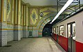 Istanbul's Tünel (1875) is the world's second-oldest subway line after London's Underground
 -
 Subway connection between Kabataş and Taksim Square
 -
 Haydarpaşa Terminal, the main railroad terminal on the Asian side of Istanbul
 -


Life in the city
Cultural activity, tourism and commerce are expected to remain important in the life of the city. However, major challenges are its demographic growth, traffic congestion, disorganized housing construction, the restoration of historic buildings and planning a 3rd motorway transition to the Bosphorus. Daily life in Istanbul is colorful and vibrant and continues side by side with many carefully protected Roman, Byzantine and Turkish monuments. Istanbul is often considered the capital of Turkey in terms of commerce, entertainment, culture, education, shopping, tourism and art. More than half the population lives and works on the European side. The large number of people living in the residential areas on the Anatolian side use bridges and ferries to commute to work in a city that has been the most popular stop for voyagers throughout history.
Art & Culture
Istanbul is becoming increasingly colorful in terms of its rich social, cultural and commercial activities. While world famous pop stars fill stadiums, activities like opera, ballet and theatre continue throughout the year. During seasonal festivals world famous orchestras, chorale ensembles, concerts and jazz legends can be found often playing to a full house. Shows are hosted at a number of locations including historical sites such as Hagia Irene, Rumeli Fortress, Yedikule, the courtyard of Topkapı Palace, and Gülhane Park; as well as the Atatürk Cultural Center, Cemal Reşit Rey Concert Hall and other open air and modern theater halls. For those who enjoy night life, there are many night clubs, pubs, restaurants and taverns with live music. The night clubs, restaurants and bars increase in number and move to open air spaces in the summer. The areas around Istiklal Avenue and Nişantaşı offer all sorts of cafés, restaurants, pubs and clubs as well as art galleries, theaters and cinemas. Biletix is a useful site to check out the latest concerts, shows, art exhibitions and cultural events in Istanbul.
Media
First Turkish newspaper is printed in 1 August 1831 Takvimi Vekayi at Babali. Babali become the main center for print media. Istanbul is also the print capital of Turkey with a wide variety of domestic and foreign periodicals expressing diverse views, and domestic newspapers are extremely competitive. Most newspapers are based in Istanbul, with simultaneous Ankara and İzmir editions[22]. The headquarters of publisher in includes Hürriyet, Milliyet, Sabah, Tercüman, Milli Gazete, Zaman, Yeni Asya, Cumhuriyet. Local Tv stations exists. Local radio stations exists.
Recreation
If one had but a single glance to give the world, one should gaze on Istanbul.
Along with Turkish restaurants, Far Eastern and other cuisines are thriving alongside many newly opened restaurants. There are thousands of alternatives for night life in Istanbul but most popular open air summer time seaside night clubs are found on the Bosphorus, such as Reina and Anjelique in the Ortaköy district. Babylon and Nu Pera in Beyoğlu are popular night clubs both in the summer and in the winter, while The Venue in Maslak often hosts live concerts of famous rock, hard rock and heavy metal bands from all corners of the world. Parkorman in Maslak hosted the Isle of MTV Party in 2002 and is a popular venue for live concerts and rave parties in the summer. Q Jazz Bar in Ortaköy offers live jazz music in a stylish environment.
The most popular places for swimming in the city are in Bakırköy, Küçükçekmece, Sarıyer and the Bosphorus. Outside the city are the Marmara Sea's Princes' Islands, Silivri and Tuzla; as well as Kilyos and Şile on the Black Sea. The Princes' Islands (Prens Adaları) are a group of islands in the Marmara Sea, south of the quarters Kartal and Pendik. Pine and stone-pine wooden neoclassical and art nouveau-style Ottoman era summer mansions from the 19th and early 20th centuries, horse-drawn carriages (motor vehicles are not permitted) and fish restaurants make them a popular trip destination. They can be reached by ferry boats and high-speed ferries (Deniz otobüsü) from Eminönü and Bostancı. Of the nine islands, five are settled. Şile is a distant and well-known Turkish seaside resort on the Black Sea, 50 kilometers from Istanbul. Unspoiled white sand beaches can be found outside of Şile. Kilyos is a small calm seaside resort not far from the northern European entrance of the Bosphorus at the Black Sea. The place has good swimming possibilities and has became popular in the last years among the inhabitants of Istanbul as a place for excursions. Kilyos offers a beach park with (fish) restaurants and discotheques.
-
Among İstanbul's many malls Kanyon captures the attention through its outstanding architecture
-
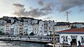 Waterfront Houses in Arnavutköy

Education
Istanbul holds some of the finest institutes of higher education in Turkey, including a number of public and private universities. Most of the reputable universities are public, but in recent years there has also been an upsurge in the number of private universities.There are many universities in the city, please see the List of universities in Istanbul for the total list.
Anadolu Liseleri ("Anatolian Highshools"), originally furnished for the Turkish children returned home from the foreign country, e.g. the Üsküdar Anadolu Lisesi with German as first foreign language and technical instruction on German Professional training-technical resuming schools. Science High schools were established with the aim of providing education to exceptionally gifted mathematics and science students; providing a source for the training of high-level scientists, in order to meet the needs of nation; encouraging students to engage in research activities ;providing facilities for students interested in working on inventions and discoveries; serving as labarotory for procedures to be implemented in the science and mathematics programs of other secondary schools. These schools offer a three-year program with a curriculum which emphasises science and mathematics. The schools have a class-size of 24 , and, in accordance with regulations, are boarding schools. The language of instruction is Turkish. Entrants to science high schools generally achieve the highest scores in the university exams.
Occupation specialized high schools Research institutes The Marmara research center (TÜBİTAK Marmara Araştırma Merkezi - TUBITAK MAM) in Gebze is with approximately 650 researcher inside and researchers the largest non-university research establishment in Turkey. It covers the institutes for information technologies, energy research, food research, chemistry and environmental research, material research, as well as ground connection and sea sciences. A technology park is attached in addition to the research center.
There are many libraries in Istanbul, for the complete listing see List of libraries in Istanbul.
Sports
The Atatürk Olympic Stadium is a five-star UEFA and first-class venue for track and field stadium, having reached the highest required standards set by the International Olympic Committee and sports federations such as IAAF, FIFA and UEFA.
Sports like basketball and volleyball are very popular. In addition to Fenerbahçe, Galatasaray and Beşiktaş, which field teams in multiple sports, other clubs have high profiles in those sports—among them Turkey's most prominent basketball clubs, Efes Pilsen and Fenerbahçe Ülker; and the Eczacıbaşı (Eczacıbaşı) and Vakifbank volleyball clubs. Golf, shooting, riding and tennis gain ever more significance. For Aerobic, bodybuilding and gymnastic equipment, numerous fitness clubs are available. Paintball belonges to the new kinds of sport and is already represented in two large clubs in the proximity of Istanbul. Eastern kinds of sport such as Aikido and Yoga have become more popular in recent years. There are several centers in the city where they can be exercised.
Istanbul hosts Formula One Turkish Grand Prix, MotoGP Grand Prix of Turkey, FIA World Touring Car Championship, GP2 and Le Mans Series 1000 km races at the Istanbul Park.
Air racing is very new to the city. On July 29, 2006, İstanbul hosted the 4th round of the spectacular Red Bull Air Race World Series above the Golden Horn
| Club | sports | League | Venue | Established | Championships |
|---|---|---|---|---|---|
| Fenerbahçe SK | football | Şükrü Saracoğlu | 16 national champions | ||
| Galatasaray SK | football | Ali Sami Yen | (1905) | UEFA Cup & the UEFA Super Cup 2000 | |
| Beşiktaş J.K. | football | İnönü Stadium | (1903) | 12 league trophies | |
| Istanbulspor | football | 2nd division | Güngören Stadium | (1926) |
-

-
The Şükrü Saracoğlu Stadium which has a capacity of 52,500 will host the 2009 UEFA Cup Final

City in popular culture
Istanbul has been featured in numerous artworks, and in digital media such as:
|
|
Sister cities
Istanbul has 45 sister cities:
Related lists
- List of museums and monuments in Istanbul
- List of urban centers in Istanbul
- List of universities in Istanbul
- List of schools in Istanbul
- List of architectural structures in Istanbul
- List of columns and towers in Istanbul
- List of libraries in Istanbul
- List of shopping malls in Istanbul
- List of mayors of Istanbul
- List of Istanbulites
See also
Notes
- ^ Prof. Dr. Murat Belge. "Kültür Haritaları Serisi" (in Turkish). National Geographic Türkiye. Retrieved 2007-01-16.
- ^ "İSKİ İstanbul Su ve Kanalizasyon İdaresi: Tarihce". Istanbul water and sewerage administration (history). Retrieved 2006-03-11.
- ^ "Istanbul advised to brace for major quake". Environmental News Network via CNN. 2000-04-28. Retrieved 2006-08-20.
{{cite news}}: Check date values in:|date=(help) - ^ "Heightened odds of large earthquakes near Istanbul: An interaction-based probability calculation". Science. 2000.
- ^ "Quake increases risk for temblor in Istanbul". MIT News Office. 1999-09-25. Retrieved 2006-08-20.
{{cite news}}: Check date values in:|date=(help) - ^ Cite error: The named reference
home rulewas invoked but never defined (see the help page). - ^ "Crime Takes a Vacation (Yours); Istanbul: Plenty of pickpockets, and sobering bar bills". The New York Times Company. Retrieved 2007-01-16.
- ^ "Travel to Turkey". U.S. Department of State Bureau of Consular Affairs. Retrieved 2007-01-16.
- ^ "Travel to Turkey". U.S. Department of State Bureau of Consular Affairs. Retrieved 2007-01-16.
- ^ "Travel to Turkey". U.S. Department of State Bureau of Consular Affairs. Retrieved 2007-01-16.
- ^ "2004 OSAC Crime and Safety Report for Istanbul". Overseas Security Advisory Council • Bureau of Diplomatic Security U.S. Department of State. Retrieved 2007-01-16.
- ^ "İstanbul Büyükşehir Belediyesi Resmi Web Sitesi". Istanbul Metropolitan Municipality (IMMWEBl). Retrieved 2007-01-01.
- ^ Baytop T. Türk Eczacýlýk Tarihi Araþtýrmalarý (History of Turkish Pharmacy Researches) Istanbul. 2000:12-75.
- ^ Dogan UVEY*, Ayse Nur GOKCE*, Ibrahim BASAGAOGLU (2004) "Pharmaceutical Industry in Turkey" in 38th International Medical History Congress in Istanbul
- ^ "Financial sector" (PDF). Foreign Economic Relations Board Turkey DEIK. Retrieved 2007-01-01.
- ^ "World Gold Council > jewellery:Turkey". World Gold Council. Retrieved 2007-01-01.
- ^ "EIBTM 2007 - The Global Meetings & Incentive Exhibition for the MICE Industry". Reed Exhibitions Limited (member of the Association of Event Organisers (AEO)). Retrieved 2006-03-11.
- ^ "İSKİ İstanbul Su ve Kanalizasyon İdaresi: Tarihce". Istanbul water and sewerage administration (history). Retrieved 2006-03-11.
- ^ "İSKİ İstanbul Su ve Kanalizasyon İdaresi: Tarihce". Istanbul water and sewerage administration (history). Retrieved 2006-03-11.
- ^ "İSKİ Administration". Istanbul water and sewerage administration. Retrieved 2006-03-11.
- ^ "CIA — The World Factbook". CIA. Retrieved 2006-03-11.
- ^ "CIA — The World Factbook". CIA. Retrieved 2006-03-11.
External links
 Definitions from Wiktionary
 Media from Commons
 News from Wikinews
 Quotations from Wikiquote
 Texts from Wikisource
 Textbooks from Wikibooks
 Resources from Wikiversity
- Istanbul Governor's Office
- Municipality of Greater Istanbul
- Istanbul guide at Wikitravel
- WikiSatellite view of Istanbul at WikiMapia

