
Lingayen: Difference between revisions
GreenC bot (talk | contribs) m 1 archive template merged to {{webarchive}} (WAM) |
Rescuing 5 sources and tagging 1 as dead. #IABot (v1.2.7.1) |
||
| Line 38: | Line 38: | ||
| leader_title1 = Vice-Mayor |
| leader_title1 = Vice-Mayor |
||
| leader_name1 = Nepthalie Dulana Pasiliao |
| leader_name1 = Nepthalie Dulana Pasiliao |
||
| area_footnotes = <ref name=nscb>{{cite web |
| area_footnotes = <ref name=nscb>{{cite web|title=Province: PANGASINAN |url=http://www.nscb.gov.ph/activestats/psgc/province.asp?regName=REGION+I+%28Ilocos+Region%29®Code=01&provCode=015500000&provName=PANGASINAN |work=PSGC Interactive |publisher=National Statistical Coordination Board |accessdate=26 November 2012 |location=Makati City, Philippines |deadurl=yes |archiveurl=https://web.archive.org/web/20121114165526/http://www.nscb.gov.ph/activestats/psgc/province.asp?regName=REGION+I+%28Ilocos+Region%29®Code=01&provCode=015500000&provName=PANGASINAN |archivedate=14 November 2012 |df= }}</ref> |
||
| area_total_km2 = 62.76 |
| area_total_km2 = 62.76 |
||
| elevation_footnotes = |
| elevation_footnotes = |
||
| elevation_m = |
| elevation_m = |
||
| population_footnotes = <ref name=NSO10>{{cite web |
| population_footnotes = <ref name=NSO10>{{cite web|url=http://www.census.gov.ph/sites/default/files/attachments/hsd/pressrelease/Ilocos.pdf |title=Total Population by Province, City, Municipality and Barangay: as of May 1, 2010 |work=2010 Census of Population and Housing |publisher=National Statistics Office |accessdate=26 November 2012 |deadurl=yes |archiveurl=https://web.archive.org/web/20121115103223/http://www.census.gov.ph/sites/default/files/attachments/hsd/pressrelease/Ilocos.pdf |archivedate=15 November 2012 |df= }}</ref> |
||
| population_total = 98740 |
| population_total = 98740 |
||
| population_as_of = 2010 |
| population_as_of = 2010 |
||
| Line 319: | Line 319: | ||
'''Pangasinan National High School''', erstwhile known as Pangasinan Academic High School, was the first public secondary school in Pangasinan. In 1946, the North and South Gabaldon buildings were constructed within the school campus.<ref name="14:">{{Cite web|url = http://www.pangasinan.gov.ph/the-province/history/|title = History|date = |accessdate = 5 April 2015|website = Official Website of Lingayen, Pangasinan|publisher = |last = |first = }}</ref> |
'''Pangasinan National High School''', erstwhile known as Pangasinan Academic High School, was the first public secondary school in Pangasinan. In 1946, the North and South Gabaldon buildings were constructed within the school campus.<ref name="14:">{{Cite web|url = http://www.pangasinan.gov.ph/the-province/history/|title = History|date = |accessdate = 5 April 2015|website = Official Website of Lingayen, Pangasinan|publisher = |last = |first = }}</ref> |
||
'''Malong Building''' is named after a Pangasinense hero named Andres Malong who led the revolt against the Spaniards from 1660 to 1661. Construction of the building started in 1956 and completed in 1958. It got a major renovation in 2008, the same year the [[Pangasinan Provincial Capitol Building]] had undergone a facelift.<ref name="15:">{{Cite web|url |
'''Malong Building''' is named after a Pangasinense hero named Andres Malong who led the revolt against the Spaniards from 1660 to 1661. Construction of the building started in 1956 and completed in 1958. It got a major renovation in 2008, the same year the [[Pangasinan Provincial Capitol Building]] had undergone a facelift.<ref name="15:">{{Cite web|url=https://www.pangasinan.gov.ph/capitolmap/malongbuilding.php |title=Malong Building 1958 |date= |accessdate=5 April 2015 |website=Official Website of Lingayen, Pangasinan |publisher= |last= |first= }}{{dead link|date=November 2016 |bot=InternetArchiveBot |fix-attempted=yes }}</ref> |
||
'''Palaris Building''', formerly known as Kalantiaw Building, was named after Datu Kalantiaw, said to have composed the first legal code of the [[Philippines]], the Code of Kalantiaw. The code was said to be fraudulent and Kalantiyaw was not a Pangasinense but an Aklanon, according to some historical accounts. The building was renamed Palaris, in honor of the heroic acts of Pantaleon Perez, also known as "Palaris" in leading the Pangasinense rebels from 1762-1764 against the Spaniards.<ref name="16:">{{Cite web|url = http://www.philstar.com/nation/724137/renaming-kalantiaw-building-psinan-sought|title = Renaming of Kalantiaw building in P'sinan sought|date = 7 September 2011|accessdate = 5 April 2015|website = |publisher = The Philippine Star|last = Visperas|first = Eva}}</ref> |
'''Palaris Building''', formerly known as Kalantiaw Building, was named after Datu Kalantiaw, said to have composed the first legal code of the [[Philippines]], the Code of Kalantiaw. The code was said to be fraudulent and Kalantiyaw was not a Pangasinense but an Aklanon, according to some historical accounts. The building was renamed Palaris, in honor of the heroic acts of Pantaleon Perez, also known as "Palaris" in leading the Pangasinense rebels from 1762-1764 against the Spaniards.<ref name="16:">{{Cite web|url = http://www.philstar.com/nation/724137/renaming-kalantiaw-building-psinan-sought|title = Renaming of Kalantiaw building in P'sinan sought|date = 7 September 2011|accessdate = 5 April 2015|website = |publisher = The Philippine Star|last = Visperas|first = Eva}}</ref> |
||
| Line 339: | Line 339: | ||
== External links == |
== External links == |
||
{{Commons category}} |
{{Commons category}} |
||
* [http://www.nscb.gov.ph/activestats/psgc/default.asp Philippine Standard Geographic Code] |
* [https://web.archive.org/web/20120413163013/http://www.nscb.gov.ph:80/activestats/psgc/default.asp Philippine Standard Geographic Code] |
||
* [http://www.census.gov.ph/ Philippine Census Information] |
* [https://web.archive.org/web/20081120024509/http://www.census.gov.ph/data/census2007/index.html Philippine Census Information] |
||
* [http://www.blgs.gov.ph/lgpmsv2/cmshome/index.php?pageID=23&frmIdDcfCode=7&fLguType=CM&frmIdRegion=2&frmIdProvince=21&frmIdLgu=302 Local Governance Performance Management System] |
* [http://www.blgs.gov.ph/lgpmsv2/cmshome/index.php?pageID=23&frmIdDcfCode=7&fLguType=CM&frmIdRegion=2&frmIdProvince=21&frmIdLgu=302 Local Governance Performance Management System] |
||
* [http://www.pangasinan.gov.ph/ Province of Pangasinan Official Website ] |
* [http://www.pangasinan.gov.ph/ Province of Pangasinan Official Website ] |
||
Revision as of 22:10, 29 November 2016
Lingayen | |
|---|---|
 Capitol Building (Poblacion) | |
| Nickname: Most Romantic Place in the Philippines | |
 Map of Pangasinan showing the location of Lingayen | |
| Country | |
| Region | Ilocos (Region I) |
| Province | Pangasinan |
| District | 2nd district of Pangasinan |
| Founded | 1614 |
| Barangays | 32 |
| Government | |
| • Mayor | Josefina Vila Castañeda |
| • Vice-Mayor | Nepthalie Dulana Pasiliao |
| Area | |
| • Total | 62.76 km2 (24.23 sq mi) |
| Population (2010)[3] | |
| • Total | 98,740 |
| • Density | 1,600/km2 (4,100/sq mi) |
| Demonym | Lingayenses |
| Time zone | UTC+8 (PST) |
| ZIP code | 2401 |
| Area code | 75 |
| Philippine Standard Geographic Code | 015522000 |
| Income class | 1st class, urban |
| Website | www |
Lingayen, officially Municipality of Lingayen (Pangasinan: Baley na Lingayen; Filipino: Bayan ng Lingayen) is a first-class municipality in the province of Pangasinan on the island of Luzon in the Philippines. It is the capital municipality and the seat of government of the province of Pangasinan. According to the 2010 census, it has a population of 98,740 people.[3] Lingayen was a strategic point during World War II. It is also the birthplace of former President Fidel V. Ramos.
History
The Augustinian missionaries and the Spanish conquistadores drew a plan of Lingayen in 1614 and Lingayen was founded. The founders named the town Lingayen at the suggestion of natives themselves, due to a certain corpulent tamarind tree growing on the present town plaza at that time. The tree was exceptionally big, tall, and spreading; that the surrounding trees were just drafts in comparison. Passers-by developed the habit of looking back and back again at this corpulent tree until it would vanish from their rear view. When they arrived home and were asked what way they took in returning they would simply say "through Liñgayen". The word "Liñgayen" was from the Pangasinan language word "lingawen" meaning " to look back". Since then up to the present time the town bears its name as Lingayen.[4][5]
Lingayen became the capital of Pangasinan when the province became an encomienda.
During World War II, Lingayen was where the Allied armies landed during the Invasion of Lingayen Gulf. Its long beach served as runway for several attack planes.
Geography
It is located along the Lingayen Gulf, the Agno River and the Limahong Channel. It has a land area of 62.76 square kilometers consisting of 32 barangays and also have 7 sitios. Its terrain is flat, suitable for farms and fisheries. Lingayen weather is cool from December to February, warm from March to April, and the wet season is between May and October.[4]
Barangays
Lingayen is politically subdivided into 32 barangays.[2]
- Aliwekwek
- Baay
- Balangobong
- Balococ
- Bantayan
- Basing
- Capandanan
- Domalandan Center
- Domalandan East
- Domalandan West
- Dorongan
- Dulag
- Estanza
- Lasip
- Libsong East
- Libsong West
- Malawa
- Malimpuec
- Maniboc
- Matalava
- Naguelguel
- Namolan
- Pangapisan North
- Pangapisan Sur
- Poblacion
- Quibaol
- Rosario
- Sabangan
- Talogtog
- Tonton
- Tumbar
- Wawa
Demographics
| Year | Pop. | ±% p.a. |
|---|---|---|
| 1990 | 77,837 | — |
| 1995 | 80,758 | +0.69% |
| 2000 | 88,891 | +2.08% |
| 2007 | 95,773 | +1.03% |
| 2010 | 98,740 | +1.12% |
| 2015 | 103,278 | +0.86% |
| Source: National Statistics Office[3][6] | ||
Climate
| Climate data for Lingayen, Pangasinan | |||||||||||||
|---|---|---|---|---|---|---|---|---|---|---|---|---|---|
| Month | Jan | Feb | Mar | Apr | May | Jun | Jul | Aug | Sep | Oct | Nov | Dec | Year |
| Mean daily maximum °C (°F) | 31 (88) |
31 (88) |
33 (91) |
34 (93) |
34 (93) |
33 (91) |
32 (90) |
31 (88) |
31 (88) |
32 (90) |
31 (88) |
31 (88) |
32 (90) |
| Mean daily minimum °C (°F) | 21 (70) |
21 (70) |
23 (73) |
25 (77) |
25 (77) |
25 (77) |
25 (77) |
24 (75) |
24 (75) |
24 (75) |
23 (73) |
22 (72) |
24 (74) |
| Average rainfall mm (inches) | 4.3 (0.17) |
19.1 (0.75) |
27.3 (1.07) |
45.2 (1.78) |
153.3 (6.04) |
271.3 (10.68) |
411.1 (16.19) |
532.0 (20.94) |
364.4 (14.35) |
182.5 (7.19) |
56.3 (2.22) |
24.4 (0.96) |
2,091.2 (82.34) |
| Average rainy days | 3 | 2 | 3 | 5 | 14 | 17 | 22 | 23 | 21 | 13 | 7 | 4 | 134 |
| Source: World Weather Online[7] | |||||||||||||
Socio-Cultural development
Lingayen poblacion has two portions, architecturally and culturally different from each other : Spanish and American because of the large influence of both two major colonizers.
The older portion influenced by Spanish is located in the southern part. The infrastructure that the Spanish planned was all town buildings face each other around a town plaza. The buildings include the Three Kings Parish Church and the Municipal Hall.
The American one built near the Lingayen Gulf consists of many provincial government buildings including the Provincial Capitol and Urduja House, all located in the Capitol Grounds.[8]
Economy
Agriculture, livestock and fishing are the major industries of the town.
Major crops include rice, corn, tomato, mongo, watermelon, and vegetables.
Livestock rising are predominant in the southern barangays where vast, long stretch of pasture lands can be found.
The major fishing ground is the Lingayen Gulf within the municipal territorial waters of fifteen (15) kilometers from the shoreline classified as the municipal fishing ground. Fisheries can be found in every barangay.
Other major industries include making of world-class bagoong (also known as "maniboc": referring to its place of origin, Barangay Maniboc) and bocayo(sweetened coconut), vinegar, furnitures, crafts made of bamboo and shingles made of nipa.[8][9]
Agriculture
The town has a land area of 3,180 hectares or 47.5% of the total land area of the municipality used for agriculture by a land survey conducted by Municipal Planning Team. Rice, being the major crop produced, have 1,500 hectares/ 22.42% of the total land area of the municipality. Corn come next with 341.50 hectares/ 5.11%, with peanut comes third with 136.6 hectares/2.04% while the rest of about 253.225 hectares or 3.78% is planted to different crops such as mongo, camote, eggplant, and other crops.[10]
Livestock
Based on the information gathered from the Office of the Municipal Agricultural Officer, shows that in year 2000 there are 5,282 heads of swine, 2,762 heads of cattle, 756 heads of carabao, 1,520 heads of sheep and goat combined, 44,000 heads of poultry (commercial broilers), and 43,875 heads of poultry (native chickens).[10]
Fishery
There are two types of fishery operation in the town depending in which water type it supply in a fishery: brackish water and freshwater.
Brackish fisheries has the bigger land area than freshwater has with a land area of 1,419.18 hectares. This fisheries can be found in 28 barangays with Baay being the largest with 157 hectares.
Freshwater fisheries has a land area of about 38.82 hectares and located in ten barangays. Namolan have the largest with 7.80 hectares.[10]
Education
The municipality is home to three colleges and one university with two campuses.
- Pangasinan State University - Both Lingayen Campus and Open University Systems
- Pangasinan Memorial College
- The Adelphi College
- St. Columban's College
Elementary Schools
Lingayen is divided in three school districts: I, II and III.[11]
Lingayen I
|
Lingayen II
|
Lingayen III
|
Lingayen Private Schools
- Harvent School
- Jesus Good Shepherd Development Center
- Saint Columban College
- Carvlex Academy
- Happy Times Christian School
- JN Montesorri high school inc.
- Grace Baptist Learning Center
High Schools
- Estanza NHS
- Pangasinan NHS
- Pangasinan School of Arts and Trades
- Lasip NHS
Integrated Schools
- Domalandan IS
- Malawa IS
Transportation
Several bus companies like Victory Liner have routes going to Lingayen from Manila, Baguio City, and Dagupan City every day. The town has a small airport, Lingayen Airport, where light planes can land and served as a community airport in Lingayen and surrounding areas.[8]
Tourism
The municipality have many beautiful attractions: Lingayen Beach, the Provincial Capitol, Urduja House, the World War II Memorabilia Ground Site, Sison Auditorium, the Narciso Ramos Sports Complex and Civic Center and the Limahong Channel. It also has two wonderful parks: the Town Park and the Capitol Grounds. The town also celebrates Pista'y Dayat (Beach Festival) in the Lingayen Beach every first of May.[8]
Heritage Structures
Heritage structures abound in the city of Lingayen. Of note are the municipality's Provincial Capitol, Urduja House, Colegio del Santissimo Rosario Ruins, and the two Gabaldon structures inside Pangasinan National High School.
Pangasinan Provincial Capitol Building is a neoclassical building designed by Ralph Harrington Doane. It was damaged during World War II and was reconstructed in 1946 with assistance from the US government under the Philippine Rehabilitation Act. With the completion of its repair and rehabilitation in 2008, the building earned the title "Best Provincial Capitol in the Philippines".
Urduja House, also called the Princess Urduja Palace, is named after the legendary warrior Princess Urduja. It currently serves as the governor's official residence and guest house.[12]
Colegio del Santissimo Rosario Ruins was constructed in 1890 as an exclusive school for girls run by the Dominican sisters. Its lumber, windows, tin roofs, and beams were used to build another school in San Manuel town, leaving the structure in ruins. At present, it is within the compound of a private property.
Pangasinan National High School, erstwhile known as Pangasinan Academic High School, was the first public secondary school in Pangasinan. In 1946, the North and South Gabaldon buildings were constructed within the school campus.[13]
Malong Building is named after a Pangasinense hero named Andres Malong who led the revolt against the Spaniards from 1660 to 1661. Construction of the building started in 1956 and completed in 1958. It got a major renovation in 2008, the same year the Pangasinan Provincial Capitol Building had undergone a facelift.[14]
Palaris Building, formerly known as Kalantiaw Building, was named after Datu Kalantiaw, said to have composed the first legal code of the Philippines, the Code of Kalantiaw. The code was said to be fraudulent and Kalantiyaw was not a Pangasinense but an Aklanon, according to some historical accounts. The building was renamed Palaris, in honor of the heroic acts of Pantaleon Perez, also known as "Palaris" in leading the Pangasinense rebels from 1762-1764 against the Spaniards.[15]
Sison Auditorium was built in Neo-classical Style, and was constructed in 1927. It was initially known as the “Grand Provincial Auditorium” in the 1930s was the popular venue for zarzuelas and other cultural performances in pre-war and early post-war period. It was later renamed after the late Governor Teofilo Sison, the first Pangasinense to become secretary of National Defense. In 2010, it had undergone a major renovation and inaugurated in the same year, April 5. At present, Sison Auditorium serves as the Cultural Center of Ilocos Region.[16]
Images
-
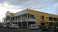 Town Hall
 -
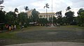 Town Park & Capitol Grounds
 -
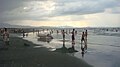 Lingayen Beach
 -
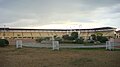 Narciso Ramos Sports Complex & Civic Center
 -
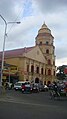 Epiphany of the Lord Parish, Poblacion


References
- ^ "Official City/Municipal 2013 Election Results". Intramuros, Manila, Philippines: Commission on Elections (COMELEC). 1 July 2013. Retrieved 5 September 2013.
- ^ a b "Province: PANGASINAN". PSGC Interactive. Makati City, Philippines: National Statistical Coordination Board. Archived from the original on 14 November 2012. Retrieved 26 November 2012.
{{cite web}}: Unknown parameter|deadurl=ignored (|url-status=suggested) (help) - ^ a b c "Total Population by Province, City, Municipality and Barangay: as of May 1, 2010" (PDF). 2010 Census of Population and Housing. National Statistics Office. Archived from the original (PDF) on 15 November 2012. Retrieved 26 November 2012.
{{cite web}}: Unknown parameter|deadurl=ignored (|url-status=suggested) (help) - ^ a b "Jumpstarting Electronic Governance in Local Government Units- Lingayen (Historical Background)". Municipality of Lingayen. Archived from the original on December 10, 2004. Retrieved February 17, 2005.
- ^ "Lingayen Official Website (Lingayen : "liñgayen")". Municipality of Lingayen. Retrieved November 6, 2010.[dead link]
- ^ "Province of Pangasinan". Municipality Population Data. LWUA Research Division. Retrieved 5 September 2013.
- ^ "Lingayen, Philippines: Average Temperatures and Rainfall". World Weather Online. Retrieved 15 September 2014.
- ^ a b c d "Jumpstarting Electronic Governance in Local Government Units- Lingayen (Local Development)". Municipality of Lingayen. Archived from the original on December 10, 2004. Retrieved December 10, 2004.
- ^ "Pasyalang Pangasinan: Lingayen". pasyalan.net. Archived from the original on April 29, 2009. Retrieved January 6, 2011.
{{cite web}}: Unknown parameter|deadurl=ignored (|url-status=suggested) (help) - ^ a b c "Jumpstarting Electronic Governance in Local Government Units- Lingayen (Agricultural Profile)". Municipality of Lingayen. Archived from the original on December 10, 2004. Retrieved December 10, 2004.
- ^ Department of Education website: Masterlist of Schools Archived July 26, 2010, at the Wayback Machine
- ^ Visperas, Eva (23 January 2015). "Revisiting the land of Urduja". Philippine Star. Retrieved 5 April 2015.
- ^ "History". Official Website of Lingayen, Pangasinan. Retrieved 5 April 2015.
- ^ "Malong Building 1958". Official Website of Lingayen, Pangasinan. Retrieved 5 April 2015.[permanent dead link]
- ^ Visperas, Eva (7 September 2011). "Renaming of Kalantiaw building in P'sinan sought". The Philippine Star. Retrieved 5 April 2015.
- ^ "Sison Auditorium, soon the North's cultural center?". Sunday Punch. 28 March 2010. Retrieved 5 April 2015.
External links
- Philippine Standard Geographic Code
- Philippine Census Information
- Local Governance Performance Management System
- Province of Pangasinan Official Website
Places adjacent to Lingayen | ||||||||||||||||
|---|---|---|---|---|---|---|---|---|---|---|---|---|---|---|---|---|
| ||||||||||||||||
