
Bahawalpur: Difference between revisions
m →Education: clean up spacing around commas, replaced: ,A → , A, ,P → , P, ,S → , S, ,t → , t, inline, title → inline,title using AWB |
Rescuing 2 sources and tagging 0 as dead. #IABot (v1.4) |
||
| Line 24: | Line 24: | ||
|subdivision_type4 = Union councils |
|subdivision_type4 = Union councils |
||
|subdivision_name4 = 36 |
|subdivision_name4 = 36 |
||
|government_footnotes = <ref name="203.215.180.58">http://203.215.180.58/portal/portal/media-type/html/group/320/page/default.psml/js_pane/P-103d7b410be-10000?nav=left</ref><ref name="203.215.180.58"/><ref>http://www.statpak.gov.pk/depts/pco/index.html</ref> |
|government_footnotes = <ref name="203.215.180.58">{{cite web|url=http://203.215.180.58/portal/portal/media-type/html/group/320/page/default.psml/js_pane/P-103d7b410be-10000?nav=left |title=Archived copy |accessdate=2009-09-17 |deadurl=yes |archiveurl=https://web.archive.org/web/20060414034050/http://203.215.180.58/portal/portal/media-type/html/group/320/page/default.psml/js_pane/P-103d7b410be-10000?nav=left |archivedate=14 April 2006 }}</ref><ref name="203.215.180.58"/><ref>http://www.statpak.gov.pk/depts/pco/index.html</ref> |
||
|government_type = |
|government_type = |
||
|leader_title = |
|leader_title = |
||
| Line 75: | Line 75: | ||
==Economy== |
==Economy== |
||
[[File:Hasilpur Bahawal Canal.jpg|thumb|Irrigation from canals such as this provides the city with fertile soil for crop production.]] |
[[File:Hasilpur Bahawal Canal.jpg|thumb|Irrigation from canals such as this provides the city with fertile soil for crop production.]] |
||
The main crops for which Bahawalpur is recognised are [[cotton]], [[sugarcane]], [[wheat]], [[sunflower seed]]s, [[rapeseed|rape]]/[[mustard seed]] and [[rice]]. Bahawalpur [[mangoes]], citrus, [[Phoenix dactylifera|dates]] and [[guavas]] are some of the fruits exported out of the country. Vegetables include [[onion]]s, [[tomato]]es, [[cauliflower]], [[potato]]es and [[carrot]]s. Being an expanding industrial city, the government has revolutionised and libertised various markets allowing the caustic soda, cotton ginning and pressing, flour mills, fruit juices, general engineering, iron and steel re-rolling mills, looms, oil mills, poultry feed, sugar, textile spinning, textile weaving, vegetable ghee and cooking oil industries to flourish.<ref>{{cite web|url=http://pportal.punjab.gov.pk/portal/portal/media-type/html/group/304/page/default.psml/js_pane/P-11aeca7c599-100e5?nav%3Dleft |title=Archived copy |accessdate=2009-09-17 |deadurl=yes |archiveurl=https://web.archive.org/web/20100903141323/http://pportal.punjab.gov.pk |
The main crops for which Bahawalpur is recognised are [[cotton]], [[sugarcane]], [[wheat]], [[sunflower seed]]s, [[rapeseed|rape]]/[[mustard seed]] and [[rice]]. Bahawalpur [[mangoes]], citrus, [[Phoenix dactylifera|dates]] and [[guavas]] are some of the fruits exported out of the country. Vegetables include [[onion]]s, [[tomato]]es, [[cauliflower]], [[potato]]es and [[carrot]]s. Being an expanding industrial city, the government has revolutionised and libertised various markets allowing the caustic soda, cotton ginning and pressing, flour mills, fruit juices, general engineering, iron and steel re-rolling mills, looms, oil mills, poultry feed, sugar, textile spinning, textile weaving, vegetable ghee and cooking oil industries to flourish.<ref>{{cite web|url=http://pportal.punjab.gov.pk/portal/portal/media-type/html/group/304/page/default.psml/js_pane/P-11aeca7c599-100e5?nav%3Dleft |title=Archived copy |accessdate=2009-09-17 |deadurl=yes |archiveurl=https://web.archive.org/web/20100903141323/http://pportal.punjab.gov.pk/portal/portal/media-type/html/group/304/page/default.psml/js_pane/P-11aeca7c599-100e5?nav=left |archivedate=3 September 2010 |df=dmy }}</ref> |
||
==Demographics== |
==Demographics== |
||
Revision as of 19:38, 13 July 2017
Bahawalpur
بہاولپور | |
|---|---|
 | |
 Bahawalpur  Bahawalpur | |
| Coordinates: 29°23′44″N 71°41′1″E / 29.39556°N 71.68361°E | |
| Country | Pakistan |
| Region | Punjab |
| District | Bahawalpur |
| Tehsil | Bahawalpur |
| Union councils | 36 |
| Area | |
| • Total | 237.2 km2 (91.6 sq mi) |
| Elevation | 181 m (702 ft) |
| Population (2014)[1] | |
| • Total | 1,052,000 |
| • Density | 4,400/km2 (11,000/sq mi) |
| Bahawalpur Urban agglomeration | |
| Time zone | UTC+5 (PKT) |
| Postal code type | 63100 |
| Area code | 063 |
| Bahawalpur / Punjab Portal | |
Bahawalpur (Punjabi, Urdu: بہاولپور), is a city located in the Punjab province of Pakistan. Bahawalpur is the 12th largest city in Pakistan with an estimated population of 798,509.[4] The city also lies near the ancient Derawar Fort in the Cholistan Desert near the border with India, and serves as the gateway to Pakistan's Lal Suhanra National Park.
Bahawalpur was once the capital of the former princely state of Bahawalpur ruled by Nawabs. The Nawabs of Bahawalpur were regarded as part of the Rajputana States, the majority of which now form the bulk of the neighbouring Indian state of Rajasthan. The Nawabs bestowed Bahawalpur with several monuments, such as the palaces of Noor Mahal, Sadiq Ghar Palace, and Darbar Mahal.
History

Bahawalpur was founded in 1748,[5] in a region near the historical city of Uch, which was once a stronghold of the Delhi Sultanate. The princely state of Bahawalpur was founded in 1802 by Nawab Mohammad Bahawal Khan II after the break-up of the Durrani Empire, and was based in the city. Nawab Mohammad Bahawal Khan III signed a treaty with the British on 22 February 1833, guaranteeing the independence of the Nawab and the autonomy of Bahawalpur as a princely state.
The city and princely state acceded to Pakistan on 7 October 1947 when Nawab Sadiq Muhammad Khan Abbasi V Bahadur[6] joined Pakistan at the time of the independence of Pakistan in 1947. Following independence, the city's minority Hindu and Sikh communities largely migrated to India en masse, while Muslim refugees from India settled in the city and surrounding region.
Geography
Bahawalpur lies immediately south of the Sutlej River, and is the site of the 4,250 foot long Empress Bridge[5] - the only railway bridge over the Sutlej in Pakistan. The city is situated 90 km from Multan, 420 km from Lahore, 122 km from Burewala, 90 km from Vehari, 270 km from Faisalabad and about 700 km from the national capital, Islamabad. The region is primarily arid desert with low annual rainfall totals. Regions to the west of the city are fertile alluvial tracts irrigated by the Sultej River. East of Bahawalpur is the Pat, or Bar - a tract of land at considerably higher altitude than the adjoining valley. Farther east, the Cholistan, is a barren desert tract, bounded on the north and west by the Hakra depression with mound ruins of old settlements along its high banks; it is still inhabited by nomads.[citation needed]
The city's climate is mainly hot and dry. In the summer the temperature reaches the high 40s (Celsius) during the day, though nights are cooler. The average temperature in summer is 33 °C (91 °F), and 18 °C (64 °F) in winter. The average rainfall is 20 to 25 cm annually.[citation needed]
Economy

The main crops for which Bahawalpur is recognised are cotton, sugarcane, wheat, sunflower seeds, rape/mustard seed and rice. Bahawalpur mangoes, citrus, dates and guavas are some of the fruits exported out of the country. Vegetables include onions, tomatoes, cauliflower, potatoes and carrots. Being an expanding industrial city, the government has revolutionised and libertised various markets allowing the caustic soda, cotton ginning and pressing, flour mills, fruit juices, general engineering, iron and steel re-rolling mills, looms, oil mills, poultry feed, sugar, textile spinning, textile weaving, vegetable ghee and cooking oil industries to flourish.[7]
Demographics
In 2007, the city's population was estimated to have risen to 798,509 from 403,408 in 1998.[4] No census has been conducted in Pakistan since 1998, although one will be completed in 2017.
Civic administration
Bahawalpur was announced as one of six cities in Punjab whose security would be improved by the Punjab Safe Cities Authority. 5.6 billion Rupees have been allocated for the project,[8] which will be modeled along the lines of the Lahore Safe City project in which 8,000 CCTV cameras were installed throughout the city at a cost of 12 billion rupees to record and send images to Integrated Command and Control Centres.[9]
Environs

The Bahawalpur Zoo, is located in Bahawalpur. Spread over an area of several acres inside the city, it contains a variety of animal species, including Asiatic lions, Bengal tigers, hyenas, leopards, and peacocks.
Located 35 kilometres east of the city is the Lal Suhanra National Park housing large animals including lions and rhinoceros.
Solar Park
Near the city the Quaid-e-Azam Solar Park is being erected, a photovoltaic power station named after Quaid-e-Azam, the founder of Pakistan. It is the first ever utility scale solar power plant in the country and is to have a capacity of 1,000 MW when finished in 2016. A first phase was brought online in April 2015 and opened by Pakistan’s Prime Minister Nawaz Sharif and Chinese President, Xi Jinping.[10][11]
Education

The city boasts a number of reputable educational establishments, most notably The Islamia University of Bahawalpur, Quaid-e-Azam Medical College, Sadiq Girls Women University and Sadiq Public School, which is one of the largest boarding schools in Pakistan. Other top schools include Beaconhouse School Bahawalpur, The Central Public High School, The Moon system of education, The City School (Pakistan), Bloomfield Hall Schools, Askari Kids College, Aims system of education, Umm Al-Qura Education System, Progressive Schooling System, Dar e arqam School, Jinnah Public School, Rangers Public School and College, The Climber Public School, Army Public School, Salsaal Public School, and Dominican Convent School. Notable universities and colleges include: Government Sadiq Egertin College, Post Graduate College, Punjab College Bahawalpur, Arrshhouse College, Government Degree College, Government Sadiq Degree College for Girls, The Islamia University of Bahawalpur, Government College of Technology, The Best College, Government Sadiq College of Commerce, Government Polytechnic Institute, Government Polytechnic Institute For Women, Government Technical Training Institute, Government Technical High School Bahawalpur, Allama Iqbal College of Commerce, Institute of Science and Information Technology and Government Para Medical School.
Transport

Bahawalpur is well connected with various cities in Pakistan. The city has its own airport built by the Dubai Civil Aviation Department and the CAA. Bahawalpur Airport links the city with various Pakistani cities such as Dera Ghazi Khan, Islamabad, Karachi and Lahore with the national flag carrier, Pakistan International Airlines. The airline has launched international flights to Dubai, and plans to introduce more international destinations. There are daily train and bus services from Multan, Lahore, Sukkur and Karachi to Bahawalpur. taxicabs and rickshaws are plentiful in the city. Cars are also available for hire in the city.
Sports
Bahawal Stadium is the multipurpose stadium, home to Bahawalpur Stags. It hosted a sole international match, a test match between Pakistan and India in 1955.
Landmarks
- Royal Palaces
- Noor Mahal
- Darbar Mahal
- Gulzar Mahal
- Nishat Mahal
- Gates
- Fareed Gate
- Derawari Gate
- Ahmedpuri Gate
- Mori Gate
- Multani Gate
- Shikarpuri Gate
- Mosques
- Abbasi Mosque
- Jamia Masjid Al Sadiq
- Bazars
- Shahi Bazar
- Rangeela Bazar
- Museums
- Bahawalpur Museum
- Libraries
- Schools
Deobandi Islamism
Deobandi Islamism was established in the Bahawalpur area during colonial times in an effort to counter the strong Sufi influence in the area. After Partition, a number of Deobandi institutions from Jalandhar and Ludhiana areas relocated to Pakistani Punjab, including to the cities of Multan and Bahawalpur. In recent years, there have been a growing number of Deobandi institutions, from which jihadis recruit a considerable number of militants to fight in Afghanistan and Kashmir.[12] There are 500 to 1000 madrassas in Bahawalpur belonging to Deobandi and Ahl-e-Hadith orientations, many of which teach a violent version of Islam to children.[13]

Maulana Masood Azhar, founder of Jaish-e-Mohammad, was born in Bahawalpur in 1968. He established a 4.5 acre walled complex outside the city that serves as a headquarters for JeM.[13]
Notable people
Kamran Hussain. He is the only International Cricketer from Bahawalpur. He Started his career in 2008 vs Zimbabwe in Faisalabad.
Gallery
-
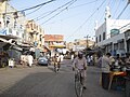 Market Inside Farid Gate
 -
 Farid Gate, Bahawalpur
 -
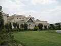
 Noor Mahal
 -
 Sadiq Dane High School, Bahawalpur
 -
 Bahawal Victoria Hospital


See also
References
- ^ http://www.demographia.com/db-worldua.pdf
- ^ a b "Archived copy". Archived from the original on 14 April 2006. Retrieved 17 September 2009.
{{cite web}}: Unknown parameter|deadurl=ignored (|url-status=suggested) (help)CS1 maint: archived copy as title (link) - ^ http://www.statpak.gov.pk/depts/pco/index.html
- ^ a b Bahawalpur: Area & Population Official Bahawalpur Government Website, Retrieved 2009-09-17
- ^ a b Wright, Arnold, ed. (1922). Indian States: A Biographical, Historical, and Administrative Survey. Asian Educational Services. p. 145. ISBN 9788120619654.
- ^ Christopher Buyers, Royal Ark website. "Bahawalpur: The Abbasi Dynasty". Archived from the original on 15 November 2007. Retrieved 13 October 2007.
{{cite web}}: Unknown parameter|deadurl=ignored (|url-status=suggested) (help) - ^ "Archived copy". Archived from the original on 3 September 2010. Retrieved 2009-09-17.
{{cite web}}: Unknown parameter|deadurl=ignored (|url-status=suggested) (help)CS1 maint: archived copy as title (link) - ^ "After Lahore, six others to become 'safer cities'". Express Tribune. 20 February 2017. Retrieved 23 February 2017.
- ^ "Punjab Safe City Project inaugurated". Dawn. 12 October 2016. Retrieved 23 February 2017.
- ^ "CM defends power schemes". The Nation. 12 September 2015. Retrieved 8 October 2015.
- ^ "Pakistan Solar Park Plugs In 100 MW To Grid". Cleantechnica. 19 June 2015. Retrieved 27 October 2015.
- ^ Talbot 2015, p. 6.
- ^ a b Shah, Saeed (13 September 2009). "Terror group builds big base under Pakistani officials' noses". McClatchy newspapers. Retrieved 2 October 2016.
Bibliography
- Moj, Muhammad (2015), The Deoband Madrassah Movement: Countercultural Trends and Tendencies, Anthem Press, ISBN 978-1-78308-389-3
- Talbot, Ian (2015), "Introduction", in Roger D. Long; Gurharpal Singh; Yunas Samad; Ian Talbot (eds.), State and Nation-Building in Pakistan: Beyond Islam and Security, Routledge, pp. 1–, ISBN 978-1-317-44820-4
- Zahab, Mariam Abou; Roy, Olivier (2004) [first published in French in 2002]. Islamist Networks: The Afghan-Pakistan Connection. Translated by King, John. C. Hurst & Co. Publishers. ISBN 978-1-85065-704-0.
External links
 Definitions from Wiktionary
 Media from Commons
 News from Wikinews
 Quotations from Wikiquote
 Texts from Wikisource
 Textbooks from Wikibooks
 Resources from Wikiversity
 Bahawalpur travel guide from Wikivoyage
- Bahawalpur at Curlie
Neighbourhoods of Bahawalpur | ||
|---|---|---|
Administrations: Bahawalpur Division and Bahawalpur District | ||
| Tehsils |  | |
| Cities | ||
| Towns and councils | ||
| Villages | ||
Website: Bahawalpur District at NRB | ||
Pakistan articles | |||||||||||||||||||
|---|---|---|---|---|---|---|---|---|---|---|---|---|---|---|---|---|---|---|---|
| |||||||||||||||||||
| |||||||||||||||||||
| |||||||||||||||||||
| |||||||||||||||||||
| |||||||||||||||||||