
Autonomous Republic of Crimea: Difference between revisions
No edit summary |
|||
| Line 104: | Line 104: | ||
On 19 February 1954, the Presidium of the [[Supreme Soviet]] of the Soviet Union issued a decree on the transfer of the Crimean Oblast from the RSFSR to the [[Ukrainian SSR]]. In post-war years, Crimea thrived as a prime tourist destination, built with new attractions and sanatoriums for tourists. Tourists came from all around the Soviet Union and neighbouring countries.<ref name="blacksea-crimea/hist" /> Also, Crimea's infrastructure and manufacturing also developed, particularly around the sea ports at [[Kerch]] and [[Sevastopol]] and in the oblast's landlocked capital, [[Simferopol]]. |
On 19 February 1954, the Presidium of the [[Supreme Soviet]] of the Soviet Union issued a decree on the transfer of the Crimean Oblast from the RSFSR to the [[Ukrainian SSR]]. In post-war years, Crimea thrived as a prime tourist destination, built with new attractions and sanatoriums for tourists. Tourists came from all around the Soviet Union and neighbouring countries.<ref name="blacksea-crimea/hist" /> Also, Crimea's infrastructure and manufacturing also developed, particularly around the sea ports at [[Kerch]] and [[Sevastopol]] and in the oblast's landlocked capital, [[Simferopol]]. |
||
With the [[History of the Soviet Union (1985–1991)|collapse of the Soviet Union]], Crimea became part of the newly independent Ukraine, a situation largely unexpected by its population.{{Citation needed|date=August 2008}} This led to tensions between Russia and Ukraine. With the [[Black Sea Fleet]] based on the peninsula, worries of armed skirmishes were occasionally raised. Crimean Tatars began returning from exile and resettling in Crimea. |
With the [[History of the Soviet Union (1985–1991)|collapse of the Soviet Union]], Crimea became part of the newly independent Ukraine, a situation largely unexpected by its population.{{Citation needed|date=August 2008}} This led to tensions between Russia and Ukraine. With the [[Black Sea Fleet]] based on the peninsula, worries of armed skirmishes were occasionally raised. Crimean Tatars began returning from exile and resettling in Crimea. Lands are still in the occupants hands and Tatars cannot recover their territory. |
||
On 26 February 1992, the [[Verkhovna Rada of Crimea|Verkhovna Rada]] (the Crimean parliament) renamed the ASSR the Republic of Crimea and proclaimed self-government on 5 May 1992<ref>{{Cite web|url=http://taylorandfrancis.metapress.com/openurl.asp?genre=article&issn=1359-7566&volume=12&issue=2&spage=65 |title= Catching up with 'Europe'? Constitutional Debates on the Territorial-Administrative Model in Independent Ukraine |accessdate=December 16, 2006 |author= |last=Wolczuk |first=Kataryna |month=August 31 | year= 2004 |work=Taylor & Francis Group }}</ref><ref>{{Cite web|url=http://www.springerlink.com/content/b3e4b28e1301017b/ |title= The Crimea Conundrum: The Tug of War Between Russia and Ukraine on the Questions of Autonomy and Self-Determination |accessdate=March 25, 2007 |author= |last=Wydra |first=Doris |month=November 11 | year= 2004 |work=SpringerLink }}</ref> and passed the first Crimean constitution the next day. |
On 26 February 1992, the [[Verkhovna Rada of Crimea|Verkhovna Rada]] (the Crimean parliament) renamed the ASSR the Republic of Crimea and proclaimed self-government on 5 May 1992<ref>{{Cite web|url=http://taylorandfrancis.metapress.com/openurl.asp?genre=article&issn=1359-7566&volume=12&issue=2&spage=65 |title= Catching up with 'Europe'? Constitutional Debates on the Territorial-Administrative Model in Independent Ukraine |accessdate=December 16, 2006 |author= |last=Wolczuk |first=Kataryna |month=August 31 | year= 2004 |work=Taylor & Francis Group }}</ref><ref>{{Cite web|url=http://www.springerlink.com/content/b3e4b28e1301017b/ |title= The Crimea Conundrum: The Tug of War Between Russia and Ukraine on the Questions of Autonomy and Self-Determination |accessdate=March 25, 2007 |author= |last=Wydra |first=Doris |month=November 11 | year= 2004 |work=SpringerLink }}</ref> and passed the first Crimean constitution the next day. |
||
Revision as of 11:31, 25 November 2010
Autonomous Republic of Crimea Автономна Республіка Крим Автономная Республика Крым Qırım Muhtar Cumhuriyeti | |
|---|---|
| Motto: Процветание в единстве (Russian) Protsvetanie v yedinstve (transliteration) "Prosperity in unity" | |
| Anthem: Нивы и горы твои волшебны, Родина (Russian) Nivy I gory tvoi volshebny, Rodina (transliteration) Your fields and mounts are wonderful, Motherland | |
 Location of Crimea (red) with respect to Ukraine (light blue). | |
 Location of Crimea (dark green) with respect to Ukraine (light green) on a map of Europe. | |
| Capital and largest city | Simferopol |
| Official languages | Ukrainian1 |
| Recognised regional languages | Russian, Crimean Tatar |
| Ethnic groups (2001) | 58.32% Russians 24.32% Ukrainians 12.10% Crimean Tatars |
| Government | Autonomous republic within Ukraine |
| Viktor Yanukovych2 | |
| Vasyl Dzharty[1] | |
| Volodymyr Konstantinov[1] | |
| Legislature | Verkhovna Rada (Crimea) |
| Autonomy from the Russian Empire / Soviet Union | |
• Declared | October 18, 1921 |
| June 30, 1945 | |
• Restored3 | February 12, 1992 |
• Constitution | October 21, 1998 |
| Area | |
• Total | 26,100 km2 (10,100 sq mi) (148th) |
| Population | |
• 2007 estimate | 1,973,185 (148th) |
• 2001 census | 2,033,700 |
• Density | 75.6/km2 (195.8/sq mi) (116th) |
| Currency | Ukrainian hryvnia (UAH) |
| Time zone | UTC+2 (EET) |
• Summer (DST) | UTC+3 (EEST) |
| Calling code | +3805 |
| Internet TLD | crimea.ua4 |
| |


Crimea (Template:Pron-en), or the Autonomous Republic of Crimea (Ukrainian: Автономна Республіка Крим, Avtonomna Respublika Krym; Russian: Автономная Республика Крым, Avtonomnaya Respublika Krym; Crimean Tatar: Qırım Muhtar Cumhuriyeti, Къырым Мухтар Джумхуриети), is an autonomous republic under the jurisdiction of Ukraine. It is located on the northern coast of the Black Sea, occupying a peninsula of the same name.[2][3][4]
The territory of Crimea was conquered and controlled many times throughout its history. The Cimmerians, Greeks, Scythians, Goths, Huns, Bulgars, Khazars, the state of Kievan Rus', Byzantine Greeks, Kipchaks, Ottoman Turks, Golden Horde Tatars and the Mongols all controlled Crimea in its early history. In the 13th century, it was partly controlled by the Venetians and by the Genovese; they were followed by the Crimean Khanate and the Ottoman Empire in the 15th to 18th centuries, the Russian Empire in the 18th to 20th centuries, the Russian Soviet Federative Socialist Republic and later the Ukrainian Soviet Socialist Republic within the Soviet Union in the rest of the 20th century, and Germany during World War II.
Crimea is now an autonomous parliamentary republic which is governed by the Constitution of Crimea in accordance with the laws of Ukraine. The capital and administrative seat of the republic's government is the city of Simferopol, located in the center of the peninsula. Crimea's area is 26,200 square kilometres (10,100 sq mi) and its population was 1,973,185 as of 2007.
Crimean Tatars, an ethnic minority who now make up about 13% of the population, formed in Crimea in the late Middle Ages, after the Crimean Khanate had come into existence. The Crimean Tatars were forcibly expelled to Central Asia by Joseph Stalin's government. After the fall of the Soviet Union, some Crimean Tatars began to return to the region.[5]
Etymology of the name
The name Crimea takes its origin in the name of a city of Qırım (today's Stary Krym) which served as a capital of the Crimean province of the Golden Horde. Qırım is Crimean Tatar for "my hill" (qır – hill, -ım – my). However, there are other versions of the etymology of Qırım. Russian Krym is a Russified form of Qırım. The ancient Greeks called Crimea Tauris (later Taurica), after its inhabitants, the Tauri. The Greek historian Herodotus mentions that Heracles plowed that land using a huge ox ("Taurus"), hence the name of the land, and thereby asserting that these people named their land, and hence themselves, after an ox used by a mythical, Greek figure.
In English, Crimea is sometimes referred to with the definite article, the Crimea, as in the Netherlands, the Gambia, etc. However, usage without the article has become more frequent in journalism since the years of the Soviet Union.
History
Early history
.jpg)
Taurica was the name of Crimea in antiquity. Taurica was inhabited by a variety of peoples. The inland regions were inhabited by Scythians and the mountainous south coast by the Taures, an offshoot of the Cimmerians. Greek settlers inhabited a number of colonies along the coast of the peninsula, notably the city of Chersonesos near modern Sevastopol. In the 2nd century BCE the eastern part of Taurica became part of the Bosporan Kingdom, before being incorporated into the Roman Empire in the 1st century BC. During the first, second and third centuries CE, Taurica was host to Roman legions and colonists in Charax, Crimea. Taurica was eventually renamed by the Crimean Tatars, from whose language the Crimea's modern name derives. The word "Crimea" comes from the Crimean Tatar name Qırım, via Greek Krimeía (Κριμαία).
Throughout the later centuries, Crimea was invaded or occupied successively by the Goths (AD 250), the Huns (376), the Bulgars (4th–8th century), the Khazars (8th century), the state of Kievan Rus' (10th–11th centuries), the Byzantine Empire (1016), the Kipchaks (Kumans) (1050), and the Mongols (1237). In the 13th century, the Republic of Genoa seized the settlements which their rivals, the Venetians, had built along the Crimean coast and gained control of the Crimean economy and the Black Sea commerce for two centuries.[citation needed]
A number of Turkic peoples, now collectively known as the Crimean Tatars, have been inhabiting the peninsula since the early Middle Ages. After the destruction of the Golden Horde by Timur in 1441, the Crimean Tatars founded an independent Crimean Khanate under Hacı I Giray, a descendant of Genghis Khan. The Crimean Tatars controlled the steppes that stretched from the Kuban and to the Dniester River, however, they were initially unable to take control over commercial Genoese towns. After the capture of Genoese towns, the Ottoman Sultan held Meñli I Giray captive,[6] later releasing him in return for accepting Ottoman sovereignty above the Crimean Khans and allowing them rule as tributary princes of the Ottoman Empire.[7][8] However, the Crimean Khans still had a large amount of autonomy from the Ottoman Empire. In 1774, The Crimean Khans fell under Russian influence with the Treaty of Küçük Kaynarca.[9] In 1783, the entire Crimea was annexed by the Russian Empire.[9]
_2007.JPG)
Crimea became part of Russia's Taurida Governorate and was the sight of much of the fighting in the Crimean War (1853–1856) which devastated much of the economic and social infrastructure of the peninsula.
Crimea in the 20th and 21st centuries
During the Russian Civil War following the overthrow of the Russian Empire, Crimea changed hands a number of times and was a stronghold of the anti-Bolshevik White Army. It was in Crimea that the White Russians led by General Wrangel made their last stand against Nestor Makhno and the Red Army in 1920.
On 18 October 1921, the Crimean Autonomous Soviet Socialist Republic was created as part of the Russian SFSR which, in turn, became part of the Soviet Union.[8] Crimea experienced two severe famines in the 20th century, the Famine of 1921–1922 and the Holodomor of 1932–1933.[10]
During World War II, Crimea was a scene of some of the bloodiest battles. The Germans suffered heavy casualties in the summer of 1941 as they tried to advance through the narrow Isthmus of Perekop linking Crimea to the Soviet mainland. Once the German army broke through, they occupied most of Crimea, with the exception of the city of Sevastopol which held out from October 1941 until 4 July 1942 when the Germans finally captured the city. From 1 September 1942, the peninsula was administered as the Generalbezirk Krim (general district of Crimea) und Teilbezirk (and sub-district) Taurien. In spite of heavy-handed tactics by the Nazis and their allies, the Crimean mountains remained an unconquered stronghold of the native resistance until the day when the peninsula was freed from the occupying force in 1944.

On 18 May 1944, the entire population of the Crimean Tatars were forcibly deported in the "Sürgün" (Crimean Tatar for exile) to Central Asia by Stalin's Soviet government as a form of collective punishment on the grounds that they had collaborated with the Nazi occupation forces.[11] An estimated 46% of the deportees died from hunger and disease. On 26 June of the same year Armenian, Bulgarian and Greek population was also deported to Central Asia. By the end of summer 1944, the ethnic cleansing of Crimea was complete. In 1967, the Crimean Tatars were rehabilitated, but they were banned from legally returning to their homeland until the last days of the Soviet Union. The Crimean ASSR was abolished in 30 June 1945 and transformed into the Crimean Oblast (province) of the Russian SFSR.
On 19 February 1954, the Presidium of the Supreme Soviet of the Soviet Union issued a decree on the transfer of the Crimean Oblast from the RSFSR to the Ukrainian SSR. In post-war years, Crimea thrived as a prime tourist destination, built with new attractions and sanatoriums for tourists. Tourists came from all around the Soviet Union and neighbouring countries.[8] Also, Crimea's infrastructure and manufacturing also developed, particularly around the sea ports at Kerch and Sevastopol and in the oblast's landlocked capital, Simferopol.
With the collapse of the Soviet Union, Crimea became part of the newly independent Ukraine, a situation largely unexpected by its population.[citation needed] This led to tensions between Russia and Ukraine. With the Black Sea Fleet based on the peninsula, worries of armed skirmishes were occasionally raised. Crimean Tatars began returning from exile and resettling in Crimea. Lands are still in the occupants hands and Tatars cannot recover their territory.
On 26 February 1992, the Verkhovna Rada (the Crimean parliament) renamed the ASSR the Republic of Crimea and proclaimed self-government on 5 May 1992[12][13] and passed the first Crimean constitution the next day.
.jpg)
On 19 May, Crimea agreed to remain part Ukraine and annulled its proclamation of self-government but Crimean Communists forced the Kiev government to expand on the already extensive autonomous status of Crimea.[14] In the same period, Russian president Boris Yeltsin and Ukraine's Leonid Kravchuk agreed to divide the former Soviet Black Sea Fleet between Russia and the newly formed Ukrainian Navy.[15]
On 14 October 1993, the Crimean parliament established the post of President of Crimea and agreed on a quota of Crimean Tatars represented in the Council of 14. However, political turmoil continued. Amendments[clarification needed] to the constitution eased the conflict[citation needed], but on 17 March 1995, the parliament of Ukraine intervened, scrapping the Crimean Constitution and removing Meshkov along with his office for his actions against the state and promoting integration with Russia.[16] After a interim constitution, the current constitution was put into effect, changing the territory's name to the Autonomous Republic of Crimea.
Following the ratification of the May 1997 Treaty of Friendship, Cooperation, and Partnership on friendship and division of the Black Sea Fleet, international tensions slowly eased off. However, in September 2008, the Ukrainian Foreign Minister Volodymyr Ohryzko accused Russia of giving out Russian passports to the population in the Crimea and described it as a "real problem" given Russia's declared policy of military intervention abroad to protect Russian citizens.[17]
On 24 August 2009, anti-Ukrainian demonstrations were held in Crimea by ethnic Russian residents. Sergei P. Tsekov said that he hoped that Russia would treat the Crimea the same way as it had treated South Ossetia and Abkhazia.[18] Chaos in the Ukrainian parliament during a debate over the extension of the lease on a Russian naval base erupted on 27 April 2010 after Ukraine’s parliament ratified the treaty that extends Russia’s lease on a military wharf and shore installations in the Crimean port Sevastopol until 2042. Along with Verkhovna Rada the treaty was ratified by the Russian State Duma as well.[19]
Government and politics
.jpg)
Crimea is a parliamentary republic that has no president. The legislative body is a 100-seat parliament, the Verkhovna Rada of Crimea.[20]
The executive power is represented by the Council of Ministers, headed by a Prime Minister who is appointed and dismissed by the Verkhovna Rada, with the consent of the President of Ukraine.[21] The authority and operation of the Verkhovna Rada and the Council of Ministers of Crimea are determined by the Constitution of Ukraine and other the laws of Ukraine, as well as by regular decisions carried out by the Verkhovna Rada of Crimea.[21]
Justice is administered by courts that belong to the judicial system of Ukraine.[21]
Elections and parties
While not an official body controlling Crimea, the Mejlis of the Crimean Tatar People is a representative body of the Crimean Tatars, which could address grievances to the Ukrainian central government, the Crimean government, and international bodies.[22]
During the 2004 presidential elections, Crimea largely voted for the presidential candidate Viktor Yanukovych. In both the 2006 Ukrainian parliamentary elections and the 2007 Ukrainian parliamentary elections, the Yanukovych-led Party of Regions also won most of the votes from the region.
Following the Crimean parliamentary election, 2006, the following political parties are represented in the Verkhovna Rada bloc: "Za Yanukovycha!" (Party of Regions and the Russian Bloc): 32.55% (44 mandates); party "Soiuz": 7.63% (10 mandates); Kunytsyna Electoral Bloc: 7.63% (10 mandates); Communist Party of Ukraine: 6.55% (9 mandates); People's Movement of Ukraine: 6.26% (8 mandates); Yulia Tymoshenko Electoral Bloc: 6.03% (8 mandates); People's Opposition Bloc of Natalia Vitrenko: 4.97% (7 mandates); Opposition Bloc "Ne Tak": 3.09% (4 mandates).[23]
Crimea – United States relations
On 18 February 2009 the Verkhovna Rada of Crimea sent a letter to the Cabinet of Ministers of Ukraine and the President of Ukraine in which it stated that it deemed it inexpedient to open a representative office of the United States in Crimea and it urged the Ukrainian leadership to give up this idea. The letter had passed in the Crimean parliament by a 77 to 9 roll-call vote with one abstention.[24] The letter would also be sent to the Chairman of the UN General Assembly.
Administrative divisions
Crimea is subdivided into 25 regions: 14 raions (districts) and 11 city municipalities, officially known as "territories governed by city councils".[25] While the City of Sevastopol is located on the Crimean peninsula, it is administratively separate from the rest of Crimea and is one of two special municipalities of Ukraine.
Raions

|
City municipalities

Major cities
|
|
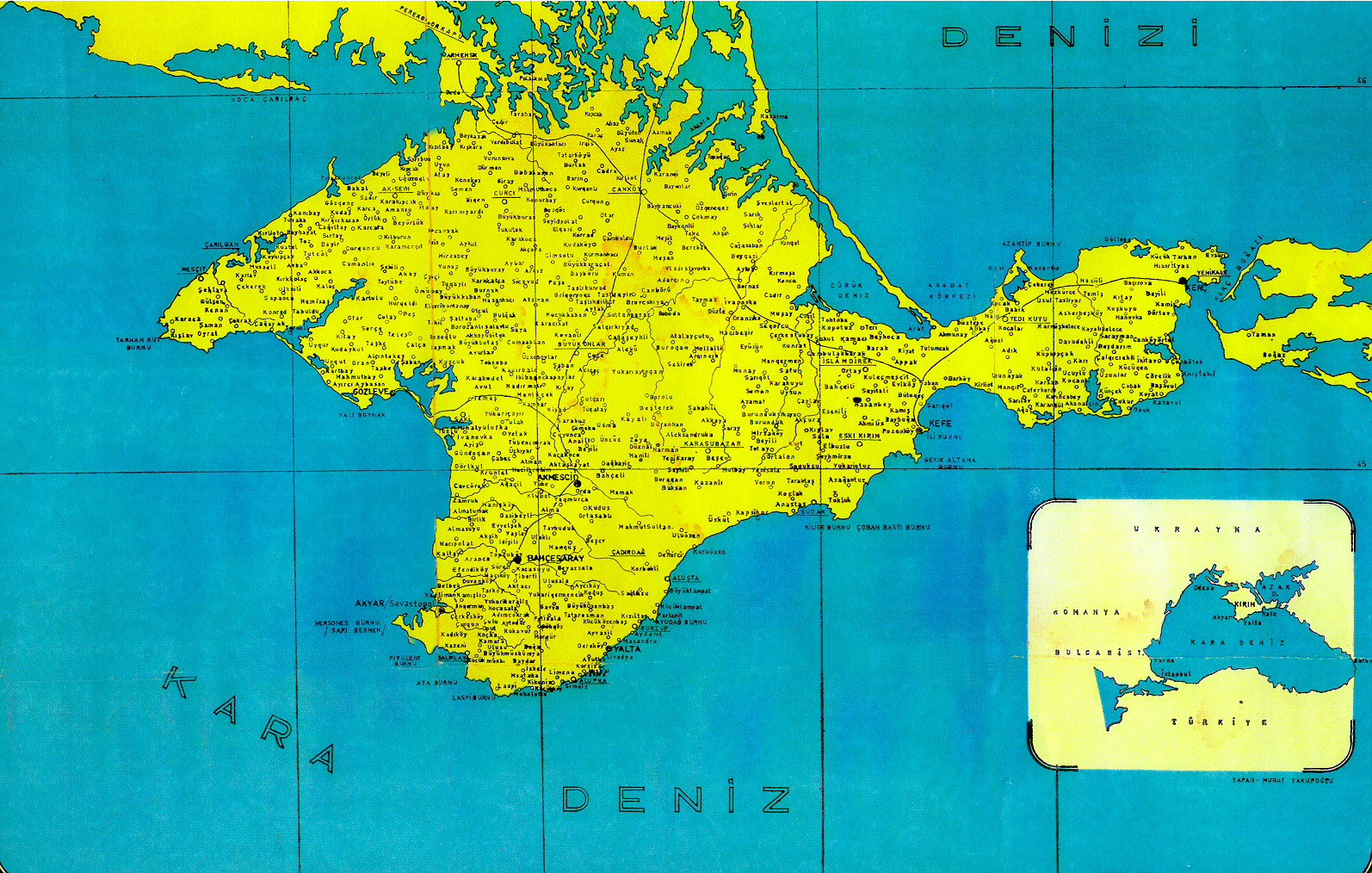
Geography and climate


Crimea is located on the northern coast of the Black Sea and on the western coast of the Sea of Azov, bordering Kherson Oblast from the North. Although located in the southwestern part of the Crimean peninsula, the city of Sevastopol has a special but separate municipality status within Ukraine. Crimea's total land area is 26,100 km2 (10,077 sq mi).
Crimea is connected to the mainland by the 5–7 kilometres (3.1–4.3 mi) wide Isthmus of Perekop. At the eastern tip is the Kerch Peninsula, which is directly opposite the Taman Peninsula on the Russian mainland. Between the Kerch and Taman peninsulas, lies the 3–13 kilometres (1.9–8.1 mi) wide Strait of Kerch, which connects the waters of the Black Sea with the Sea of Azov.
The Crimean coastline is broken by several bays and harbors. These harbors lie west of the Isthmus of Perekop by the Bay of Karkinit; on the southwest by the open Bay of Kalamita, with the ports of Eupatoria and Sevastopol; on the north by the Bay of Arabat of the Isthmus of Yenikale or Kerch; and on the south by the Bay of Caffa or Feodosiya, with the port of Feodosiya.
The southeast coast is flanked at a distance of 8–12 kilometres (5.0–7.5 mi) from the sea by a parallel range of mountains, the Crimean Mountains.[26] These mountains are backed by secondary parallel ranges. Seventy-five percent of the remaining area of Crimea consists of semiarid prairie lands, a southward continuation of the Pontic steppes, which slope gently to the northwest from the foot of the Crimean Mountains. The main range of these mountains shoots up with extraordinary abruptness from the deep floor of the Black Sea to an altitude of 600–750 metres (1,969–2,461 ft), beginning at the southwest point of the peninsula, called Cape Fiolente. It was believed that this cape was supposedly crowned with the temple of Artemis, where Iphigeneia is said to have officiated as priestess.[27] Uchan-su waterfall on the south slope of the mountains is the highest in Ukraine.
Numerous kurgans, or burial mounds, of the ancient Scythians are scattered across the Crimean steppes.
The terrain that lies beyond the sheltering Crimean Mountain range is of an altogether different character. Here, the narrow strip of coast and the slopes of the mountains are smothered with greenery. This "riviera" stretches along the southeast coast from Cape Sarych, in the extreme south, to Feodosiya, and is studded with summer sea-bathing resorts such as Alupka, Yalta, Gurzuf, Alushta, Sudak, and Feodosiya. During the years of Soviet rule, the resorts and dachas of this coast served as the prime perquisites of the politically loyal. In addition, vineyards and fruit orchards are located in the region. Fishing, mining, and the production of essential oils are also important. Numerous Crimean Tatar villages, mosques, monasteries, and palaces of the Russian imperial family and nobles are found here, as well as picturesque ancient Greek and medieval castles.
Most of Crimea has a temperate continental climate, except for the south coast where it experiences a humid subtropical climate, due to warm influences from the Black Sea. Summers can be hot (28 °C (82.4 °F)* Jul average) and winters are cool (−0.3 °C (31.5 °F)* Jan average) in the interior, on the south coast winters are milder (4 °C (39.2 °F)* Jan average) and temperatures much below freezing are exceptional. Precipitation in the interior is low with only 400 mm (15.7 in) a year. On the south coast precipitation is more than double of that, Yalta annually receives about 1,050 mm (41.3 in). Because of its climate, the southern Crimean coast is a popular beach and sun resort for Ukrainian and Russian tourists.


Places of interest
- Livadia Palace
- Mount Mithridat
- Scyth's treasure
- Swallow's Nest
- Tauric Chersonesos
- Vorontsov's Palace (Alupka)
Economy

The main branches of the Crimean economy are tourism and agriculture. Industrial plants are situated for the most part in the northern regions of the republic. Important industrial cities include Dzhankoy, housing a major railway connection, Krasnoperekopsk and Armyansk, among others.
The most important industries in Crimea include food production, chemical fields, mechanical engineering and metal working, and fuel production industries.[21] Sixty percent of the industry market belongs to food production. There are a total of 291 large industrial enterprises and 1002 small business enterprises.[21]
The main branches of vegetation production in the region include cereals, vegetable-growing, gardening, and wine-making, particularly in the Yalta and Massandra regions. Other agricultural forms include cattle breeding, poultry keeping, and sheep breeding.[21] Other products produced on the Crimea Peninsula include salt, porphyry, limestone, and ironstone (found around Kerch).[28]
Transport
Almost every settlement in Crimea is connected with another settlement with bus lines. Crimea contains the longest (96 km or 59 mi) trolleybus route in the world, stretching from Simferopol to Yalta.[29] The trolleybus line starts in near Simferopol's Railway Station through the mountains to Alushta and on to Yalta.
The cities of Yalta, Feodosiya, Kerch, Sevastopol, Chornomorske and Yevpatoria are connected to one another by sea routes. In the cities of Yevpatoria and nearby townlet Molochnoye are tram systems. Railroad lines running through Crimea include Armyansk—Kerch (with a link to Feodosiya), and Melitopol—Sevastopol (with a link to Yevpatoria), connecting Crimea to the Ukrainian mainland.
Demographics

| Part of a series on |
| Crimean Tatars |
|---|
| By region or country |
| Religion |
| Language |
| Culture |
| History |
| People and groups |
As of 2005, the total population of Crimea is 1,994,300.
From 1989 to 2001, Crimea's population declined by 396,795 people, representing 16.33% of the 1989 population, despite the return of displaced groups such as Crimean Tatars. From 2001–2005 the population declined by another 39,400 people, representing a decline from 2001 of another 2%.
According to 2001 Ukrainian Census, the population of Crimea was 2,033,700.[30] The ethnic makeup was comprised the following self-reported groups: Russians: 58.32%; Ukrainians: 24.32%; Crimean Tatars: 12.1%; Belarusians: 1.44%; Tatars: 0.54%; Armenians: 0.43%; and Jews: 0.22%.[31]
Other minorities are Black Sea Germans, Romani people, Bulgarians, Poles, Azerbaijanis, Koreans, Greeks and Italians. The number of Crimea Germans was 45,000 in 1941.[32] In 1944, 70,000 Greeks and 14 000 Bulgarians from the Crimea were deported to Central Asia and Siberia,[33] along with 200,000 Crimean Tatars and other nationalities.[34]
Ukrainian is the single official state language countrywide, and is the sole language of government in Ukraine. In Crimea government business is still carried out mainly in Russian. Attempts to expand the usage of Ukrainian in education and government affairs have been less successful in Crimea than in other areas of the nation.[35] Another language widely spoken is Crimean Tatar. According to the census mentioned, 77% of Crimean inhabitants named Russian as their native language; 11.4% – Crimean Tatar; and 10.1% – Ukrainian.[36]
Currently two thirds of the migrants into Crimea are from other regions of Ukraine; every 5th migrant is from the former Soviet Union and every 40th from outside of it. Three quarters of those leaving Crimea move to other areas in Ukraine. Every 20th migrates to the West.[36]
Demographic trends
The population of the Crimean peninsula has been consistently falling at a rate of 0.4% per year.[37] This is particularly apparent in both the Russian and Ukrainian ethnic populations, whose growth rate has been falling at the rate of 0.6% and 0.12% annually respectively. In comparison, the overall growth rate of the ethnic Crimean Tatar population has been growing at the rate of 0.9% per annum.[38]
The growing trend in the Crimean Tatar population has been explained by the continual Crimean Tatar repatriation (mainly from Uzbekistan), the high birth rate amongst the resettlers, and the low death rate as few senior citizens have resettled back into their ancestral home.
Culture
Sport
Crimea is a prominent figure in Ukrainian sports, especially the most popular: Association football. The most successful Crimean football club is Tavriya Simferopol in the Ukrainian Premier League possessing one championship title. In the Ukrainian First League Crimea is represented by FC Feniks-Illychovets Kalinine, FC Ihroservice Simferopol, FC Krymteplitsia Molodizhne and PFC Sevastopol. In the Second League Crimea has the club FC Tytan Armyansk.
Crimea is represented within Ukrainian Bandy and Rink-bandy Federation.[39]
See also
Further reading
- Template:Ru icon Bazilevich Basil Mitrofanovich. (1914) From the history of the Moscow-Crimea relations in the first half of XVII century (Из истории московско-крымских отношений в первой половине XVII века) at Runivers.ru in DjVu and PDF formats
- Template:Ru icon Bantysh-Kamensky Nikolay. (1893) Register of cases of Crimean yard with 1474 to 1779 (Реестр делам крымского двора с 1474 по 1779 год) at Runivers.ru in DjVu and PDF formats
- Template:Ru icon Berg Nikolai. (1858) Sevastopol album by N. Berg (Севастопольский альбом Н. Берга) at Runivers.ru in DjVu and PDF formats
- Template:Ru icon Berezhkov Michael N.Plan for the conquest of the Crimea compiled during the reign of Emperor Alexis of Russia Slav scholar Yuri Krizhanich (План завоевания Крыма составленный в царствование государя Алексея Михайловича ученым славянином Юрием Крижаничем) at Runivers.ru in DjVu and PDF formats
- Template:Ru icon Berezhkov Michael N. (1888) Russian captives and slaves in the Crimea (Русские пленники и невольники в Крыму) at Runivers.ru in DjVu and PDF formats
- Template:Ru icon Bogdanovich Modest I. (1876) Eastern War 1853-1856 (Восточная война 1853-1856 гг.) at Runivers.ru in DjVu format
- Template:Ru icon Dubrovin Nikolai Fedorovich. (1900) History of the Crimean War and the defense of Sevastopol (История Крымской войны и обороны Севастополя) at Runivers.ru in DjVu format
- Template:Ru icon Dubrovin Nikolai Fedorovich. (1885-1889) Joining the Crimea to Russia (Присоединение Крыма к России) at Runivers.ru in DjVu format
Footnotes and references
- ^ a b Vasyl Dzharty of Regions Party heads Crimean government, Kyiv Post (March 17, 2010)
- ^ Regions and territories: The Republic of Crimea
- ^ Autonomous Republic of Crimea
- ^ Government Portal of The Autonomous Republic of Crimea
- ^ Pohl, J. Otto. The Stalinist Penal System: A Statistical History of Soviet Repression and Terror. Mc Farland & Company, Inc, Publishers. 1997. 23.
- ^ Soldier Khan
- ^ Subtelny, Orest (2000). Ukraine: A History. University of Toronto Press. p. 78. ISBN 0-8020-8390-0.
{{cite book}}: External link in|title= - ^ a b c "History". blacksea-crimea.com. Retrieved March 28, 2007.
- ^ a b Subelny, 176.
- ^ Famine in Crimea
- ^ Subtelny, 483.
- ^ Wolczuk, Kataryna (2004). "Catching up with 'Europe'? Constitutional Debates on the Territorial-Administrative Model in Independent Ukraine". Taylor & Francis Group. Retrieved December 16, 2006.
{{cite web}}: Unknown parameter|month=ignored (help) - ^ Wydra, Doris (2004). "The Crimea Conundrum: The Tug of War Between Russia and Ukraine on the Questions of Autonomy and Self-Determination". SpringerLink. Retrieved March 25, 2007.
{{cite web}}: Unknown parameter|month=ignored (help) - ^ Subtelny, 587.
- ^ Ready To Cast Off, TIME Magazine, June 15, 1992
- ^ Laws of Ukraine. Verkhovna Rada law No. 93/95-вр: On the termination of the Constitution and some laws of the Autonomous Republic of Crimea. Adopted on 1995-03-17. (Ukrainian)
- ^ Cheney urges divided Ukraine to unite against Russia 'threat. Associated Press. September 6, 2008.
- ^ Russia and Ukraine in Intensifying Standoff
- ^ Update: Ukraine, Russia ratify Black Sea naval lease, Kyiv Post (April 27, 2010)
- ^ The Verkhovna Rada of Crimea should not be confused with the national Verkhovna Rada of Ukraine.
- ^ a b c d e f "Autonomous Republic of Crimea – Information card". Cabinet of Ministers of Ukraine. Retrieved February 22, 2007.
- ^ Ziad, Waleed (2007). "A lesson in stifling violent extremism". CS Monitor. Retrieved March 26, 2007.
{{cite web}}: Unknown parameter|coauthors=ignored (|author=suggested) (help); Unknown parameter|month=ignored (help) - ^ "Results of the Verkhovna Rada of Crimea elections are accepted". REGNUM (in Russian). 2006. Retrieved April 28, 2007.
{{cite web}}: Unknown parameter|month=ignored (help) - ^ Crimean parliament votes against opening U.S. diplomatic post, Interfax-Ukraine (18 February 2009)
- ^ "Infobox card — Avtonomna Respublika Krym". Verkhovna Rada of Ukraine (in Ukrainian). Retrieved February 23, 2007.
- ^ The Crimean Mountains may also be referred to as the Yaylâ Dağ or Alpine Meadow Mountains.
- ^ See the article "Crimea" in the Encyclopædia Britannica Eleventh Edition.
- ^ Bealby, John T. (1911). Encyclopædia Britannica Eleventh Edition. Cambridge University Press. p. 449.
- ^ "The longest trolleybus line in the world!". blacksea-crimea.com. Retrieved January 15, 2007.
- ^ "Regions of Ukraine / Autonomous Republic of Crimea". 2001 Ukrainian Census. Retrieved December 16, 2006.
- ^ "Results / General results of the census / National composition of population". 2001 Ukrainian Census. Retrieved December 16, 2006.
- ^ "A People on the Move: Germans in Russia and in the Former Soviet Union: 1763 – 1997". North Dakota State University Libraries.
- ^ "The Persecution of Pontic Greeks in the Soviet Union" (PDF)
- ^ "Crimean Tatars Divide Ukraine and Russia". The Jamestown Foundation. June 24, 2009.
- ^ Bondaruk, Halyna (2007). "Yushchenko Appeals to Crimean Authority Not to Speculate on Language". Ukrayinska Pravda. Retrieved March 25, 2007.
{{cite web}}: Unknown parameter|month=ignored (help) - ^ a b "Results / General results of the census / Linguistic composition of the population / Autonomous Republic of Crimea". 2001 Ukrainian Census. Retrieved December 16, 2006.
- ^ Falling Population growth rate in Crimea (in Ukrainian)
- ^ Population growth in Crimea (in Ukrainian)
- ^ http://www.ukrbandy.org.ua/contact_en.html
- Subtelny, Orest (2000). Ukraine: A History. University of Toronto Press. p. 78. ISBN 0-8020-8390-0.
- "Autonomous Republic of Crimea – Information card". Cabinet of Ministers of Ukraine. Retrieved February 22, 2007.
- This article incorporates text from a publication now in the public domain: Chisholm, Hugh, ed. (1911). Encyclopædia Britannica (11th ed.). Cambridge University Press.
{{cite encyclopedia}}: Missing or empty|title=(help) - Crimea, terra di mille etnie, 1993 di Giuseppe D'Amato in Il Diario del Cambiamento. Urss 1990 – Russia 1993. Greco&Greco editori, Milano, 1998. pp. 247–252. ISBN 88-7980-187-2 (The Diary of the Change. USSR 1990 – Russia 1993) Book in Italian.
- Crimea, la penisola regalata di Giuseppe D'Amato in L’EuroSogno e i nuovi Muri ad Est. L’Unione europea e la dimensione orientale. Greco&Greco editori, Milano, 2008. pp. 99–107 ISBN 978-88-7980-456-1 (The EuroDream and the new Walls at East. The European Union and the Eastern dimension) Book in Italian.
External links
 Definitions from Wiktionary
 Media from Commons
 News from Wikinews
 Quotations from Wikiquote
 Texts from Wikisource
 Textbooks from Wikibooks
 Resources from Wikiversity
Official links
- crimea-portal.gov.ua — Official portal of the Council of Ministers of Crimea Template:En icon/Template:Uk icon/Template:Ru icon/Template:Fr icon
- rada.crimea.ua — Official web-site of the Verkhovna Rada of Crimea
Informational links
- Gallery Fotos
- Iconicarchive Fotogallery
- Cabinet of Ministers of Ukraine — Information card of the region
- WikiTravel — Guide to Crimea
- [1]- Crimean TRavel information, Pictures and Galleries in English language
- Crimea Information, Where to stay, What to visit,Crimean Tour guide
 Wikimedia Atlas of Crimea
- United Nations Crimea Integration and Development Programme
- Crimea Tourism
- Maps of all Crimea cities, towns and villages
- Old map of Crimea
- List of hotels with contacts
- Photos of Crimea Template:En icon

Geographic locale | |||||||||||||||||||
|---|---|---|---|---|---|---|---|---|---|---|---|---|---|---|---|---|---|---|---|
| |||||||||||||||||||
