
Heraclea at Latmus

Heraclea at Latmus (Ancient Greek: Ἡράκλεια πρὸς Λάτμῳ, romanized: Herakleia pros Latmo; Latin: Heraclea ad Latmum), or simply Heraclea or Herakleia (Ἡράκλεια), also transliterated as Heracleia, was a town on the confines between ancient Caria and Ionia, situated at the western foot of Mount Latmus on the Gulf of Latmus, which has since silted up. During the Hellenistic period it bore the name Pleistarcheia,[1] probably after Pleistarchus. It was a small place in the south-east of Miletus, and south-west of Amyzon. In its neighbourhood a cave was shown with the tomb of Endymion.[2][3][4][5] Ruins of this town still exist at the foot of mount Latmus on the borders of Lake Bafa, which is probably a portion of the ancient Sinus Latmicus, formed by the deposits of the river Maeander.
The place must have Christianised early as an early bishopric is attested. No longer a residential see, it remains a titular see of the Roman Catholic Church.[6]
Its site is co-located with the village of Kapıkırı, Asiatic Turkey.[1][7]
Gallery
-
 Herakleia at Latmus – Defensive towers
 -
 Herakleia at Latmus – Defensive tower
 -
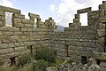 Herakleia at Latmus – Defensive tower
 -
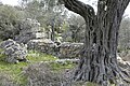
 Herakleia at Latmus – At agora
 -
 Herakleia at Latmus – At agora
 -
 Herakleia at Latmus – At agora
 -
 Herakleia at Latmus – Agora
 -
 Herakleia at Latmus – Temple of Athena seen from the agora
 -
 Herakleia at Latmus – Athena temple
 -
 Herakleia at Latmus – Athena temple
 -
 Herakleia at Latmus – View south to Byzantine castle from Temple of Athena
 -
 Herakleia at Latmus – Necropolis
 -
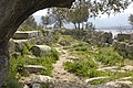
 Herakleia at Latmus – Unidentified remains
 -
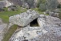
 Herakleia at Latmus – Near Endymion temple
 -
 Herakleia at Latmus – Endymion temple
 -
 Herakleia at Latmus – Monastery on island in Lake Bafa
 -
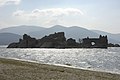
 Herakleia at Latmus – Byzantine Castle
 -
 Herakleia at Latmus – Byzantine Castle
 -
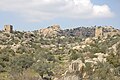
 Kapiri village
 -
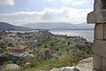
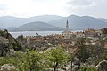 Kapiri village with Lake Bafa in the background


References
- ^ a b Richard Talbert, ed. (2000). Barrington Atlas of the Greek and Roman World. Princeton University Press. p. 61, and directory notes accompanying. ISBN 978-0-691-03169-9.
- ^ Periplus of Pseudo-Scylax, p. 39; Strabo. Geographica. Vol. xiv. p.635. Page numbers refer to those of Isaac Casaubon's edition.
- ^ Ptolemy. The Geography. Vol. 5.2.9.
- ^ Pliny. Naturalis Historia. Vol. 5.31.
- ^ Polyaen. 7.23; Schol. ad Apollon. Rhod. 4.57; Pausanias (1918). "1.4". Description of Greece. Vol. 5. Translated by W. H. S. Jones; H. A. Ormerod. Cambridge, Massachusetts; London: Harvard University Press; William Heinemann – via Perseus Digital Library.
- ^ Catholic Hierarchy
- ^ Lund University. Digital Atlas of the Roman Empire.
![]() This article incorporates text from a publication now in the public domain: Smith, William, ed. (1854–1857). "Heracleia". Dictionary of Greek and Roman Geography. London: John Murray.
This article incorporates text from a publication now in the public domain: Smith, William, ed. (1854–1857). "Heracleia". Dictionary of Greek and Roman Geography. London: John Murray.
37°29′51″N 27°31′37″E / 37.49759°N 27.52707°E
| International | |
|---|---|
| National | |
| Geographic | |
This article about a former Greek populated place in Asia Minor is a stub. You can help Wikipedia by expanding it. |