
Tagaytay
Tagaytay | |
|---|---|
| City of Tagaytay | |
 View of the Tagaytay Highlands | |
| Nickname: The Country’s 2nd Summer Capital | |
 Map of Cavite showing the location of Tagaytay | |
| Country | Philippines |
| Region | CALABARZON (Region IV-A) |
| Province | Cavite |
| Congr. districts | 7th District of Cavite |
| Cityhood | June 21, 1938 |
| Barangays | 34 |
| Government | |
| • Mayor | Agnes Tolentino |
| • Vice Mayor | Celso P. de Castro |
| Area | |
| • Total | 65.00 km2 (25.10 sq mi) |
| Elevation | 634 m (2,080 ft) |
| Population (2010)[3] | |
| • Total | 62,030 |
| • Density | 950/km2 (2,500/sq mi) |
| Demonym | Tagaytayeño |
| Time zone | UTC+8 (PST) |
| ZIP code | 4120 |
| Dialing code | 46 |
| Website | www |
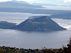
Tagaytay, officially the City of Tagaytay (Filipino: Lungsod ng Tagaytay), is a component city in the province of Cavite, in the Philippines. It is one of the country's most popular tourist destinations because of its outstanding scenery and cooler climate provided by its high altitude. Tagaytay overlooks Taal Lake in Batangas and provides one of the iconic views of the Philippines, the view of Taal Volcano Island in the middle of the lake, viewable from several vantage points in the city.
Tagaytay is relatively close to the capital city of Manila, only 55 km (34 mi) away via Aguinaldo Highway, providing an easy escape for the locals from the heat of the big city.
Geography
Land area
Tagaytay City has a total land area of 66.1 km2 (26 sq mi) which represents about 4.37% of the total area of the Province of Cavite. It lies within 120° 56' longitude and 14° 6' latitude and overlooks Manila Bay to the North, Taal Volcano and Lake to the south and Laguna de Bay to the east.
Topography

The southern and eastern portions of Tagaytay City are covered by hills and mountains which is generally forests and open grasslands. The city lies along Tagaytay Ridge, a ridge stretching about 32 kilometres (20 mi) from Mount Batulao in the west to Mount Sungay (now People's Park in the Sky) in the east with elevations averaging about 610 metres (2,000 ft) above sea level.[4] Mount Sungay, in Tagaytay, is the highest point of the province of Cavite at 709 metres (2,326 ft).[5]
The ridge, which overlooks Taal Lake in Batangas province, is the edge of Taal Caldera. The 25-by-30-kilometre (16 mi × 19 mi) wide cavity is partially filled by Taal Lake.[6] Tagaytay's built-up areas including the urban center is situated in the relatively level top of the caldera rim but beyond the edge are deep ravines that drop steeply to Taal Lake. The portions adjoining the municipalities of Mendez, Indang, Amadeo, Silang and Alfonso are level to nearly level areas interspersed with very gently sloping surface. Across the southern edge of the lake on the opposite side of the city is Mount Macolod, the highest point of the Taal Caldera rim.
Climate
- Temperature and precipitation
Tagaytay City has a more moderate version of a tropical monsoon climate (Köppen climate classification: Am) characterized by relatively milder temperatures compared to Manila, lower humidity and abundant rainfall. The City has an average temperature of 24 °C (75 °F). With its high elevation, the city could be misty at times and is relatively cooler during the months of December, January and February. Like most areas in the province of Cavite, the city has two pronounced seasons: dry from November to April and wet during the rest of the year. The climate has made the city ideal for sports, picnics, conferences, honeymoons, country homes, and spiritual retreats.
- Humidity
Tagaytay has an average humidity of 78% which makes the city cooler than Metro Manila where relative humidity exceeds 81%. Northeasterly winds prevail in the City from October to April. Winds come from southwest from May to September. The cool Tagaytay breeze has made the city ideal for casual and competitive kite flying.
| Climate data for Tagaytay | |||||||||||||
|---|---|---|---|---|---|---|---|---|---|---|---|---|---|
| Month | Jan | Feb | Mar | Apr | May | Jun | Jul | Aug | Sep | Oct | Nov | Dec | Year |
| Mean daily maximum °C (°F) | 26.9 (80.4) |
27.8 (82.0) |
29 (84) |
30.1 (86.2) |
29.7 (85.5) |
28.4 (83.1) |
27.2 (81.0) |
27 (81) |
27.4 (81.3) |
27.9 (82.2) |
27.4 (81.3) |
26.8 (80.2) |
28.0 (82.4) |
| Daily mean °C (°F) | 22.8 (73.0) |
23.3 (73.9) |
24.2 (75.6) |
25.3 (77.5) |
25.3 (77.5) |
24.6 (76.3) |
23.7 (74.7) |
23.7 (74.7) |
23.8 (74.8) |
24.1 (75.4) |
23.6 (74.5) |
23.1 (73.6) |
24.0 (75.1) |
| Mean daily minimum °C (°F) | 18.8 (65.8) |
18.8 (65.8) |
19.5 (67.1) |
20.6 (69.1) |
21 (70) |
20.8 (69.4) |
20.2 (68.4) |
20.5 (68.9) |
20.3 (68.5) |
20.3 (68.5) |
19.9 (67.8) |
19.4 (66.9) |
20.0 (68.0) |
| Average precipitation mm (inches) | 51 (2.0) |
27 (1.1) |
32 (1.3) |
54 (2.1) |
205 (8.1) |
301 (11.9) |
451 (17.8) |
459 (18.1) |
363 (14.3) |
252 (9.9) |
213 (8.4) |
138 (5.4) |
2,546 (100.4) |
| Source: Climate-Data.org,[7] | |||||||||||||
History
Etymology
Legend has it that the word Tagaytay came from "taga" meaning to cut and "itay" which means father. A father and son were said to be on a wild boar hunt when the animal they were chasing turned and attacked them. As the boar charged towards the old man, the son cried "taga itay!". The boy's repeated shout reverberated in the alleys of the ridge. Heard by the residents, hunters and wood gatherers, the cries became subject of conversation for several days in the countryside. In time, the place where the shouts came from became known as Tagaytay.[8]
"Tagaytay", however, is Tagalog for "ridge".
Philippine revolution
During the Philippine revolution of 1896, the ridges and forests of Tagaytay became the sanctuary for revolutionaries including those from nearby provinces. The passage to and from towns via Tagaytay added the word "mananagaytay" to the native's vocabulary. It means "to traverse ridges."[8]
World War II
On February 3, 1945, the 11th Airborne Division of Lt. Gen. Robert L. Eichelberger's 8th Army performed a combat jump of the 511th Parachute Infantry Regiment and associated elements on the ridge, with a drop zone around the Manila Hotel Annex, which had been cleared of Japanese forces by Filipino soldiers of the 4th, 41st, 42nd, 43rd, 45th and 46th Infantry Division of the Philippine Commonwealth Army, 4th Infantry Regiment of the Philippine Constabulary and recognized guerillas. To commemorate this event, a marker was installed in 1951 at the junction of Silang, Canlubang-Nasugbu roads by the city officials in coordination with the National Historical Institute of the Philippines.[8]

Timeline
- 1749. Taal Volcano destroyed the entire Volcano Island and the towns of Taal, old Sala and part of old Tanauan.
- 1754. The eruption of Taal Volcano destroyed towns of Sala, Lipa, Tanauan and Talisay.
- 1911. Another eruption devastated Volcano Island killing 1,334 people with ashes reaching Manila.
- 1937. Construction ensues on Tagaytay ridge. Taal Vista Lodge is built by the construction firm Pedro Siochi and Company and to be run by the Manila Hotel Corporation. Cavite prisoners construct the long highway stretching from Silang up to the ridge. This is the continuation of the Aguinaldo Highway, named after the First President of the Republic of the Philippines, Emilio Aguinaldo.
- 1938. Tagaytay became a chartered city with the passing and signing of Commonwealth Act no. 338 by President Manuel L. Quezon on January 21, 1938, as authored by Rep. Justiniano Montano of Cavite.[9]
- 1965. The Volcano affected the entire Volcano Island; ashfall covered an area of 60 square kilometres (23 sq mi) and killed 200 people.
- 1979. Former First Lady Imelda Marcos brought a major change to the landscape of the city. Mount Sungay was leveled to about half of its former prominence to accommodate the Palace in the Sky, a mansion originally intended as a guesthouse for former California Gov. Ronald Reagan - who never arrived. The half-finished Palace in the Sky became the People's Park in the Sky after the People Power Revolution, which toppled the government of President Ferdinand Marcos.
- 2004. Hon. Abraham N. Tolentino was elected City Mayor of Tagaytay.
- 2004. Received the Nutrition Honor Award in October 15, 20014, the highest award given to a local government unit by the National Government for outstanding implementation of nutrition programs/activities.
- 2004. Mayor Abraham N. Tolentino was elected as National Treasurer of the League of Cities of the Philippines(LCP).
- 2005. Mayor Abraham N. Tolentino Launched the Hanggang sa Kabilang Buhay Services(HSKBS), a funeral service which offers affordable yet dignified funeral services.
- 2006. The Best Proposal Award on Local Action for Social Determinants of Health in Urban Settings: Shelter and Housing was given by the World Health Organization on October 28, 2006.
- 2007. Hon. Abraham N. Tolentino was reelected City Mayor of Tagaytay.
- 2007. Tagaytay City was awarded as the Cleanest and Greenest City in the Province.
- 2008. Mayor Abraham N. Tolentino was invited by the Health Ministry of the People's Republic of China and World Health Organization to share the best practices of Tagaytay City on health Programs.
- 2008. In Celebration of Tagaytay 70th Anniversary, Tagaytay kicks off campaign to stop global warming, together with the City Government Officials, Employees, Religious Organization, Establishments and Schools launched the planting of 10,000 Araucaria pine trees in Tagaytay City.
- 2009. Tagaytay City thru the leadership of Mayor Abraham N. tolentino was one of the Finalist in the Presidential Award for the Most Child Friendly City in March 12, 2009.
- 2009. The Tagaytay Special Education(SPED) Center was established by Mayor Abraham N. Tolentino.
- 2009. Bagong Tubig Elementary School, Tagaytay City awarded by the National Educational Testing & Research Center(NETRC) as the top Public School for earning the Highest Mean Percentage Score of 93% on Cluster 6 in the National Achievement Test for Grade 6.
- 2009. A new City College of Tagaytay Building was inaugurated, one of the flagship projects of Mayor Abraham N. Tolentino. The 3- storey building has 36 classrooms, Laboratoy, Computer room, Admin Office and Library.
- 2009. Tagaytay City joins Cities around the World in the Celebration of Earth Hour on March 29, 2009, Business, Offices and residents altogether switched off their lights from 8:30 PM to 9:30 PM.
- 2010. For his 3rd term, Hon. Abraham N. Tolentino was reelected City Mayor of Tagaytay.
- 2010. For the 2nd time, Tagaytay City was chosen as one of the Finalist for the Presidential Award for the Most Child Friendly City in April 22, 2010. On October 29, 2010, Mayor Abraham N. Tolentino received the Award from World Health Organization(WHO) the Best Proposal Award for Innovative Projects in Healthy Cities.
- 2010. Tagaytay City was awarded as the "Outstanding in Child Health Care Award" by the Office of the President - Council for the Welfare of Children in April 22, 2010.
- 2010. Tagaytay City was adjudged Most Outstanding LGU ALS Literacy Program Implementer.
- 2010. Ordinance No. 2010 - 065 authored by Mayor Ambraham N. Tolentino thru committee on education declaring Free College Education in Tagaytay at City College of Tagaytay.
- 2010. Mayor Abraham N. Tolentino inaugurated two housing projects, Pabahay sa Las Brisas at Pabahay sa Barangay Patutong Malaki South.
- 2010. Mayor Abraham N. Tolentino turned-over 10 units of UHF handheld radios to the Tagaytay City Component Police Station.
- 2011. For the 3rd time, Tagaytay City was one of the Finalist for the Presidential Award for the Most Child Friendly City.
- 2011. Tagaytay City thru the leadership of Mayor Abraham N. Tolentino in coordination with Museu Pambata open the Exhibit "Money Matters" at the City Hall Lobby.
- 2011. The new Sungay Elementary School Building was inaugurated located adjacent to Tagaytay City Science National High School at Barangay Sungay West.
- 2011. Tagaytay City gathers Expats to launch the First Tagaytay International BBQ Day in May 2011 with US Ambassador Harry R. Thomas as Special Guest.
- 2011. Tagaytay PNP inaugurates modern police community precincts, funded/constructed by the City Government of Tagaytay thru the leadership of Mayor Abraham N. Tolentino, CALABARZON Police Director Chief Supt. Samuel Pagdilao Jr. and Cavite Police Director Sr. Supt. Danilo Maligalig and City Officials of Tagaytay City were present during the inauguration.
- 2011. Tagaytay City opened the newly built Tagaytay City Crematorium, Hanggang sa Kabilang Buhay Chapel and Columbarium located at Barangy Maitim II West.
- 2011. Haikou, China Officials visited Tagaytay to strengthen the Sister City relationship between the two cities.
- 2011. Tagaytay Tourism Council launched its first Tagaytay Family Fun Run aimed to highlight the Filipino development and socio-economic growth and strengthen the promotion of Tagaytay as a wholesome family destination.
- 2011. Tagaytay City Hosted the 2011 National Inter-Province Chess Team Championship.
- 2011. May 24, 2011, Tagaytay City hosted the Asian Zone Chess Championship.
- 2011. Dr. Agnes D. Tolentino - First lady of Tagaytay and Chairperson of Kababaihan Kabalikat sa Kaunlaran ng Tagaytay(KKKT) launched the Tulong Pangkabuhayan para sa mga Kababaihan ng Tagaytay.
- 2011. April 4, 2011, Tagaytay City launched the door to door measles supplemental immunization campaign in support to the Department of health "Iligtas sa Tigdas ang Pinas" program.
- 2011. The following projects were inaugurated: [1]Waiting Sheds in Brgy. San Jose, Silang Crossing East, Kaybagal South and Sungay. [2]Comport Room(Track & Field Oval). [3]Maitim II East Barangay Hall. [4]Ospital ng Tagaytay Extension.
- 2012. Awarded by the Alliance for Healthy Cities as Pioneers in Healthy Cities on October 25, 2012.
- 2012. Seal of Good Housekeeping(Bronze) was awarded to the City by the Department of Interior and Local Government.
- 2012. Best Practices Award for enforcement of 100% Indoor Smoke-Free Workplaces, Bars & Restaurants was received by the City from World Health Organization.
- 2013. In May 2013 election, the first Lady Mayor - Hon. Agnes D. Tolentino, DMD was elected City Mayor Of Tagaytay.
- 2013. On July 3, 2013, the first Outstanding Pabasa sa Nutrition Program was awarded to the city by the City Nutrition Council.
- 2013. Tagaytay City was awarded- the First Presidential Award for the Most Child Friendly City on April 17, 2013.
- 2014. The construction/development of a new High School "Tagaytay City West National High School" was completed.
- 2014. Restoration of RC Pipes and Riprap at Barangay Neogan was completed.
- 2015. The construction of Basketball court at Brgy. Sambong was completed in March 2015.
- 2015. Construction of 5-storey school building with basketball court(Phase I) was completed.
- 2015. For the 2nd time, Tagaytay City was awarded the Presidential Award for the Most Child Friendly City on May 8, 2015.
- 2015. The Sigtuna Open Hall at TICC Compound was constructed.
- 2015. TICC Perimeter fence was repainted.
- 2015. The new Barangay Hall of Brgy. Guinhawa South was constructed and Day Care Center was reconstructed.
- Updating of data is ongoing...
Barangays
Tagaytay is administratively subdivided into 34 barangays.[10]
- Asisan
- Bagong Tubig
- Calabuso
- Dapdap East
- Dapdap West
- Francisco
- Guinhawa North
- Guinhawa South
- Iruhin East
- Iruhin South
- Iruhin West
- Kaybagal Central
- Kaybagal North
- Kaybagal South (Pob.)
- Mag-Asawang Ilat
- Maharlika East
- Maharlika West
- Maitim 2nd Central
- Maitim 2nd East
- Maitim 2nd West
- Mendez Crossing East
- Mendez Crossing West
- Neogan
- Patutong Malaki North
- Patutong Malaki South
- Sambong
- San Jose
- Silang Junction North
- Silang Junction South
- Sungay East
- Sungay West
- Tolentino East
- Tolentino West
- Zambal
Demographics
| Year | Pop. | ±% p.a. |
|---|---|---|
| 1990 | 23,739 | — |
| 1995 | 29,419 | +4.10% |
| 2000 | 45,287 | +9.69% |
| 2007 | 61,623 | +4.34% |
| 2010 | 62,030 | +0.24% |

As of the 2010 census by the National Statistics Office, Tagaytay has a population of 62,030 people.[3] Christianity is the majority religion of Tagaytayeños with Roman Catholicism as the most dominant sect compromising of 95.36 percent of the total population. The next prominent sect among residents of Tagaytay are Iglesia ni Cristo (3.37%) and Protestantism (1.07%). The rest of the population (0.20%) subscribes to other religions. Tagalog is the most dominant language in the city with 93.58% of the population speaking the language. The next prominent Philippine languages are Bicolano (1.52%), Ilocano (1.52%), and Cebuano (1.00%).[11]
Economy
Agriculture

Despite rapid urbanization of Tagaytay, agriculture remains an important part of the city's economy and development. As of 2009, it is recordeed that there is about 1,292 hectares (3,190 acres) of agriculture land which is about 20 percent of the city's total land area. The main agricultural goods produced are pineapple, coffee, banana, root crops, other fruits and vegetables, and cut flowers which are supplied to both local and international markets.[12]
Tourism

Tagaytay is considered to be the second Summer capital of the Philippines with the first being Baguio due to its cool climate thus is a favored destination from those relatively more humid areas of the Philippines. Tagaytay is also a popular destination for tourists seeking a panoramic view of Taal Volcano and the surrounding lake. In 2015, the Department of Tourism cites Tagaytay as the top tourist destination in the Calabarzon region through the years. Among the most visited sites in Tagaytay are the Sky Ranch Amusement Park, Picnic Grove Complex, People's Park in the Sky, Paradizoo and the One Destination, a restaurant and bar strip. Tagaytay's proximity to Metro Manila is attributed to the tourism in the city. Tagaytay receives seasonal influx of tourists during the Christmas season.[13][14]
Transportation
Roads

Tagaytay is linked by national highways to the Metro Manila area and to the provinces of Batangas and Laguna. It is also connected by secondary roads to the adjoining municipalities of Amadeo, Mendez, Indang, Silang and Alfonso in Cavite towards the northwest, and to the cities of Calamba and Santa Rosa in Laguna in the northeast and to the town of Talisay in Batangas in the south.
Tagaytay is roughly about two hours drive from Manila via the South Luzon Expressway depending on the traffic, exiting at Santa Rosa then via Santa Rosa-Tagaytay Road. It can also be reached via the Coastal Road Expressway and then taking Aguinaldo Highway heading south towards Tagaytay.
There are daily public buses that ply the route to Tagaytay from Manila. Several bus companies have their terminals in Cubao, EDSA, Pasay, and at Baclaran, beside Coastal Mall Integrated Provincial Bus Terminal below LRT, Manila. Jeepneys that ply from Cavite (Imus, Dasmarinas, Silang) to Nasugbu, Batangas also pass by Tagaytay via the Aguinaldo Highway.
From Batangas, the best way to reach Tagaytay is to head to Talisay, Batangas, then go up to Tagaytay via the 12-kilometre (7.5 mi) Tagaytay-Talisay Road, which ends at the Tagaytay City Circle. From Laguna, one may head to Santa Rosa, Laguna and take the Santa Rosa-Tagaytay Road.
In 2011, cable car and funicular rides are already available to transport guests to different parts of the Tagaytay Highlands.
Gallery
-
 Taal Volcano's Binintiang Malaki cinder cone as seen from the Tagaytay Picnic Grove
 -
 Tagaytay Picnic Grove
 -
 SM Wind Residences
 -
 Robinsons Summit Ridge Promenade
 -
 Canossa House of Spirituality
 -
 Mount Sungay, the highest point of Tagaytay where People's Park in the Sky is located.
 -
 View of Sky Eye from Taal Vista Hotel


Sister cities
References
- ^ "Official City/Municipal 2013 Election Results". Intramuros, Manila, Philippines: Commission on Elections (COMELEC). 11 September 2013. Retrieved 24 October 2013.
- ^ "Province: CAVITE". PSGC Interactive. Makati City, Philippines: National Statistical Coordination Board. Retrieved 29 October 2013.
- ^ a b "Total Population by Province, City, Municipality and Barangay: as of May 1, 2010" (PDF). 2010 Census of Population and Housing. National Statistics Office. Retrieved 29 October 2013.
- ^ "Tagaytay City - Geography". Cavite Province Official Website. Retrieved on 2012-02-04.
- ^ "Mount Sungay". Mountains Mounts. Retrieved on 2012-02-04.
- ^ "Taal Volcano Flyer". Philippine Institute of Volcanology and Seismology. Retrieved on 2012-02-07.
- ^ "Climate: Tagaytay - Climate graph, Temperature graph, Climate table". Climate-data.org. Retrieved 25 May 2014.
- ^ a b c "Tagaytay City Ecological Profile 2013" (PDF). Tagaytay City Official Website. Tagaytay City Government. pp. 1–2. Retrieved 15 November 2015.
- ^ "History". Official Website of Tagaytay City. Retrieved on 2012-02-04.
- ^ Philippine Standard Geographic Code listing for Tagaytay - National Statistical Coordination Board.
- ^ "Tagaytay City Ecological Profile 2013" (PDF). Tagaytay City Official Website. Tagaytay City Government. pp. 27–28. Retrieved 15 November 2015.
- ^ "Updated City Development Strategy Report for Tagaytay City 9 Mar 2009" (PDF). Cities Alliance. Cities Alliance. 9 March 2009. Retrieved 15 November 2015.
- ^ Giron, Anthony (3 January 2015). "Tagaytay not far behind with 500,000 tourist arrivals". Manila Bulletin. Retrieved 15 November 2015.
- ^ Limpin, Rogelio (14 December 2014). "Tagaytay tourist visits to reach 2M". The Manila Times. Retrieved 15 November 2015.
- ^ PIA - Sisterhood agreement between Tagaytay and San Nicolas signed Archived 2014-12-13 at the Wayback Machine
External links
Places adjacent to Tagaytay | |
|---|---|
.svg)