
Ghaziabad: Difference between revisions
→History: Corrected spelling of Nehru from Nehry |
m Removed unsorced material |
||
| Line 67: | Line 67: | ||
| area_code_type = Telephone code |
| area_code_type = Telephone code |
||
| area_code = 91-120 |
| area_code = 91-120 |
||
| registration_plate = UP-14 |
| registration_plate = UP-14 |
||
| website = http://ghaziabad.nic.in/ |
| website = http://ghaziabad.nic.in/ |
||
| footnotes = |
| footnotes = |
||
}} |
}} |
||
'''Ghaziabad''' ({{IPA-hi|ɣaːziːaːbaːd̪}}) is a city in the [[India]]n state of [[Uttar Pradesh]]. sometimes referred to as the "Gateway of UP" because it neighbours [[New Delhi]] and is the main route to Uttar Pradesh.<ref>{{cite web|title=Ghaziabad Nagar Nigam|url=http://ghaziabad.nic.in/}}</ref> It is a part of the [[National Capital Region]] of [[Delhi]].<ref>{{cite web|title=National Capital Region- Constituent Areas|url=http://ncrpb.nic.in/ncrconstituent.php|publisher=NCRPB}}</ref> It is a large and planned industrial city, well connected by roads and railways, and is the administrative headquarters of [[Ghaziabad district, India|Ghaziabad District]] as well as being the primary commercial, industrial and educational centre of [[western Uttar Pradesh]] and a major rail junction for [[North India]].<ref>{{cite book|last1=Athique and Hill|first1=Adrian and Douglas|title=The Multiplex in India: A Cultural Economy of Urban Leisure|location=New York|pages=110–114|edition=2010|url=http://books.google.co.in/books?id=NbaLAgAAQBAJ&pg=PA111&dq=Ghaziabad&hl=en&sa=X&ei=1heUU-WTB4WTuATR94KgDw&ved=0CFEQ6AEwCA#v=onepage&q=Ghaziabad&f=false}}</ref><ref>{{cite web|title=District and Sessions Court Ghaziabad- History|url=http://ghaziabad.nic.in/court_new/history.html|publisher=NIC}}</ref> Recent construction works have led to the city being described by a City Mayors Foundation survey as the second-fastest growing in the world.<ref>{{cite web|title=Business: |date=17 November 2011|url=http://www.rediff.com/business/slide-show/slide-show-1-the-fastest-growing-cities-in-india/20111117.htm |archiveurl=http://web.archive.org/web/20111120003527/http://www.rediff.com/business/slide-show/slide-show-1-the-fastest-growing-cities-in-india/20111117.htm|archivedate=20 November 2011|deadurl=no}}</ref><ref>Ghaziabad was first listed in early 2010 as # 420 by size. {{cite web|title=The largest cities in the world and their mayors: Cities ranked 301 to 450 |url=http://www.citymayors.com/statistics/largest-cities-mayors-301.html|publisher=City Mayors|archiveurl=http://web.archive.org/web/20100309063818/http://www.citymayors.com/statistics/largest-cities-mayors-301.html|archivedate=9 March 2010|deadurl=yes}}, current listings: {{cite web|url=http://www.citymayors.com/statistics/urban_growth1.html |title=World's fastest growing urban areas (1) |publisher=City Mayors}}</ref> Situated in the Upper Gangetic Plains, the city has two major divisions separated by the [[Hindon River]], namely: Trans-Hindon on the west and Cis-Hindon on the east side.<ref name="GNN">{{cite web|title=Ghaziabad Nagar Nigam: About Us |url=http://www.nagarnigamghaziabad.com/aboutus.html|archiveurl=http://web.archive.org/web/20130201100341/http://www.nagarnigamghaziabad.com/aboutus.html|archivedate=1 February 2013|deadurl=yes}}</ref> It is known for its |
'''Ghaziabad''' ({{IPA-hi|ɣaːziːaːbaːd̪}}) is a city in the [[India]]n state of [[Uttar Pradesh]]. sometimes referred to as the "Gateway of UP" because it neighbours [[New Delhi]] and is the main route to Uttar Pradesh.<ref>{{cite web|title=Ghaziabad Nagar Nigam|url=http://ghaziabad.nic.in/}}</ref> It is a part of the [[National Capital Region]] of [[Delhi]].<ref>{{cite web|title=National Capital Region- Constituent Areas|url=http://ncrpb.nic.in/ncrconstituent.php|publisher=NCRPB}}</ref> It is a large and planned industrial city, well connected by roads and railways, and is the administrative headquarters of [[Ghaziabad district, India|Ghaziabad District]] as well as being the primary commercial, industrial and educational centre of [[western Uttar Pradesh]] and a major rail junction for [[North India]].<ref>{{cite book|last1=Athique and Hill|first1=Adrian and Douglas|title=The Multiplex in India: A Cultural Economy of Urban Leisure|location=New York|pages=110–114|edition=2010|url=http://books.google.co.in/books?id=NbaLAgAAQBAJ&pg=PA111&dq=Ghaziabad&hl=en&sa=X&ei=1heUU-WTB4WTuATR94KgDw&ved=0CFEQ6AEwCA#v=onepage&q=Ghaziabad&f=false}}</ref><ref>{{cite web|title=District and Sessions Court Ghaziabad- History|url=http://ghaziabad.nic.in/court_new/history.html|publisher=NIC}}</ref> Recent construction works have led to the city being described by a City Mayors Foundation survey as the second-fastest growing in the world.<ref>{{cite web|title=Business: |date=17 November 2011|url=http://www.rediff.com/business/slide-show/slide-show-1-the-fastest-growing-cities-in-india/20111117.htm |archiveurl=http://web.archive.org/web/20111120003527/http://www.rediff.com/business/slide-show/slide-show-1-the-fastest-growing-cities-in-india/20111117.htm|archivedate=20 November 2011|deadurl=no}}</ref><ref>Ghaziabad was first listed in early 2010 as # 420 by size. {{cite web|title=The largest cities in the world and their mayors: Cities ranked 301 to 450 |url=http://www.citymayors.com/statistics/largest-cities-mayors-301.html|publisher=City Mayors|archiveurl=http://web.archive.org/web/20100309063818/http://www.citymayors.com/statistics/largest-cities-mayors-301.html|archivedate=9 March 2010|deadurl=yes}}, current listings: {{cite web|url=http://www.citymayors.com/statistics/urban_growth1.html |title=World's fastest growing urban areas (1) |publisher=City Mayors}}</ref> Situated in the Upper Gangetic Plains, the city has two major divisions separated by the [[Hindon River]], namely: Trans-Hindon on the west and Cis-Hindon on the east side.<ref name="GNN">{{cite web|title=Ghaziabad Nagar Nigam: About Us |url=http://www.nagarnigamghaziabad.com/aboutus.html|archiveurl=http://web.archive.org/web/20130201100341/http://www.nagarnigamghaziabad.com/aboutus.html|archivedate=1 February 2013|deadurl=yes}}</ref> It is known for its crime rate.<ref>{{cite web|author=Vikram, Kumar|title=North News: Gangs of Ghaziabad! When it comes to 'gun power', civilians in Ghaziabad beat cops hands down |publisher=India Today |date=16 December 2012|url=http://indiatoday.intoday.in/story/a-booming-gun-culture-stumps-ghaziabad-police-shooting-spree/1/237983.html |archiveurl=http://web.archive.org/web/20121216205729/http://indiatoday.intoday.in/story/a-booming-gun-culture-stumps-ghaziabad-police-shooting-spree/1/237983.html|archivedate=16 December 2012|deadurl=no}}</ref><ref>{{cite news|author=Jahagirdar, Archana |title=Ghaziabad has long way to go|publisher=Times Of India |date=5 July 2006 |url=http://articles.timesofindia.indiatimes.com/2006-07-05/edit-page/27820870_1_ghaziabad-satellite-townships-cities |accessdate=16 April 2013}}</ref><ref>{{cite news|author=Chakraborty, Tapas |title=20km from Delhi, a ‘child kidnap capital’ |publisher=The Telegraph|location=Calcutta, India |date=6 August 2012|url=http://www.telegraphindia.com/1120806/jsp/nation/story_15818959.jsp |accessdate=16 April 2013}}</ref> and for being the most polluted city in Uttar Pradesh.<ref>{{cite news| url=http://articles.timesofindia.indiatimes.com/2013-07-03/pollution/40350145_1_air-pollution-urban-areas-ghaziabad | work=The Times Of India | title=The Times of India: Latest News India, World & Business News, Cricket & Sports, Bollywood}}</ref> It is the second largest industrial city in [[Uttar Pradesh]] after [[Kanpur]].<ref name="ghaziabad1">{{cite web|url=http://ghaziabad.nic.in/court_new/history.html |title=district and session court-ghaziabad |publisher=Ghaziabad.nic.in |date= |accessdate=2014-06-17}}</ref> |
||
==History== |
==History== |
||
| Line 83: | Line 83: | ||
Ghaziabad was associated with the [[Indian independence movement]] from the [[Indian Rebellion of 1857]].<ref name="nagarnigamghaziabad.com"/> During that rebellion, there were fierce clashes between the British forces and Indian rebel [[sepoy]]s on the banks of the [[Hindon River|Hindon]], and the rebels checked the advancing British forces coming from Meerut.<ref>{{cite web|url=http://indpaedia.com/ind/index.php/1857:_The_aftermath |title=1857: The aftermath |publisher=Indpaedia |date=2014-02-20 |accessdate=2014-06-17}}</ref> |
Ghaziabad was associated with the [[Indian independence movement]] from the [[Indian Rebellion of 1857]].<ref name="nagarnigamghaziabad.com"/> During that rebellion, there were fierce clashes between the British forces and Indian rebel [[sepoy]]s on the banks of the [[Hindon River|Hindon]], and the rebels checked the advancing British forces coming from Meerut.<ref>{{cite web|url=http://indpaedia.com/ind/index.php/1857:_The_aftermath |title=1857: The aftermath |publisher=Indpaedia |date=2014-02-20 |accessdate=2014-06-17}}</ref> |
||
Before 14 November 1976 Ghaziabad was the Tehsil of District Meerut. The then chief minister Mr. N.D.Tiwari decalered Ghaziabad as a district on 14 November 1976, on the birth anniversary of Pt. Jawahar Lal Nehru, the first prime minister of India. From then Ghaziabad has moved forward leaps and bounds on the social, economic, agriculture and individual front. |
|||
Ghaziabad, the headquarter of the district of the same name, lies on the Grand Trunk road about a mile east of the Hindon river in Lat. 280 40' North and Long. 770 25' East, 19 km east of Delhi and 46 km south-west of Meerut with which it is connected by a metalled road. Other roads lead north-wesr to Loni and Baghpat and east to Hapur and Garhmukteshwar. Buses run at freequent intervals from here to Delhi, Meerut,Aligarh,Bulandshahar, Moradabad, Lucknow and to other districts also. It is an important station on the Northern Railway where railway lines, from Delhi to Calcutta, Moradabad and Saharanpur meet, connecting it with many important cities of India. |
|||
As its boundary is adjacent to Delhi, it acts as the main entrance of Uttar Pradesh and that is why it is also called the GATEWAY OF U.P. |
|||
===Industrial growth=== |
===Industrial growth=== |
||
Although connected by railway since 1865, it was not until 1940 that the first modern industry appeared in Ghaziabad. That business was [[Amrit Vanaspati Co. Ltd.]] and it was followed by eight other major concerns, including [[Modern Industries]], [[Federal Chemical Works]], [[Ghaziabad Engineering Company]], [[Asia Chemicals]] and the [[Webbing and Belting Factory Ltd]]. However, it was in the post-independence period that industry really expanded, with a further 22 factories opening in the four years after 1947. This development can be attributed to the influx of people from the newly formed Pakistan and the relocation of businesses such as |
Although connected by railway since 1865, it was not until 1940 that the first modern industry appeared in Ghaziabad. That business was [[Amrit Vanaspati Co. Ltd.]] and it was followed by eight other major concerns, including [[Modern Industries]], [[Federal Chemical Works]], [[Ghaziabad Engineering Company]], [[Asia Chemicals]] and the [[Webbing and Belting Factory Ltd]]. However, it was in the post-independence period that industry really expanded, with a further 22 factories opening in the four years after 1947. This development can be attributed to the influx of people from the newly formed Pakistan and the relocation of businesses such as Guru Nanak Engineering and Punajb Oil Expellers from what was now the Pakistani province of [[Punjab (Pakistan)|Punjab]].<ref>{{cite book|last1=Saxena|first1=Aruna|title=Perspectives in industrial geography : a case study of an industrial city of Uttar Pradesh|date=1989|publisher=Concept Pub. Co.|location=New Delhi|isbn=8170222508|pages=30, 92, 98|url=http://books.google.co.uk/books?id=o31qeLOxQYsC}}</ref> John Oakey and Mohan Ltd., one of India's largest concerns manufacturing coated and bonded abrasives, and originally functioning under the name of 'National Abrasives' at [[Rawalpindi]] was shifted here under the proprietorship of 'Dyer Meakins' in 1947.<ref>{{cite book|last1=Saxena|first1=Aruna|title=Perspectives in industrial geography : a case study of an industrial city of Uttar Pradesh|date=1989|publisher=Concept Pub. Co.|location=New Delhi|isbn=8170222508|page=172}}</ref> Subsequently, the [[Mohan Meakin]] breweries were also set up in the year 1949.<ref>{{cite web|url=http://www.mohanmeakin.com/index.php |title=Mohan Meakin Group |publisher=Mohanmeakin.com |date= |accessdate=2014-06-17}}</ref> This period also saw the development of Ghaziabad as one of India's most famous centres of the Oil Engines industry.<ref>{{cite book|last1=Saxena|first1=Aruna|title=Perspectives in industrial geography : a case study of an industrial city of Uttar Pradesh|date=1989|publisher=Concept Pub. Co.|location=New Delhi|isbn=8170222508|page=92}}</ref> |
||
In 1967, the municipal limits were extended up to the Delhi-UP border. Starting early 1970s, a large number of steel manufacturing units also came up in the city making it one of the primary industries of the city. This period also saw the emergence of the Electronics industry, with the setting up of [[Bharat Electronics Limited]] and [[Central Electronics Limited]]<ref>{{cite book|last1=Saxena|first1=Aruna|title=Perspectives in industrial geography : a case study of an industrial city of Uttar Pradesh|date=1989|publisher=Concept Pub. Co.|location=New Delhi|isbn=8170222508|pages=97, 98}}</ref> Over the years, planned Industrial development saw participation from major industrial houses of the country including Mohans (Mohan Nagar Industrial Estate, 1949), Tatas (Tata Oil Mills), Modis (Modinagar, 1933; International Tobacco Co. 1967), Shri Rams (Shri Ram Pistons, 1964), Jaipurias etc. and also significant participation through foreign capital in concerns such as Danfoss India Ltd. ( estd. 1968); Indo- Bulgar Food Ltd. and International Tobacco Company (estd. 1967).<ref>{{cite book|last1=Saxena|first1=Aruna|title=Perspectives in industrial geography : a case study of an industrial city of Uttar Pradesh|date=1989|publisher=Concept Pub. Co.|location=New Delhi|isbn=8170222508|pages=124, 93, 11, 39, 69|url=http://books.google.co.in/books?id=o31qeLOxQYsC&pg=PA1&dq#v=onepage&q&f=false}}</ref> |
In 1967, the municipal limits were extended up to the Delhi-UP border. Starting early 1970s, a large number of steel manufacturing units also came up in the city making it one of the primary industries of the city. This period also saw the emergence of the Electronics industry, with the setting up of [[Bharat Electronics Limited]] and [[Central Electronics Limited]]<ref>{{cite book|last1=Saxena|first1=Aruna|title=Perspectives in industrial geography : a case study of an industrial city of Uttar Pradesh|date=1989|publisher=Concept Pub. Co.|location=New Delhi|isbn=8170222508|pages=97, 98}}</ref> Over the years, planned Industrial development saw participation from major industrial houses of the country including Mohans (Mohan Nagar Industrial Estate, 1949), Tatas (Tata Oil Mills), Modis (Modinagar, 1933; International Tobacco Co. 1967), Shri Rams (Shri Ram Pistons, 1964), Jaipurias etc. and also significant participation through foreign capital in concerns such as Danfoss India Ltd. ( estd. 1968); Indo- Bulgar Food Ltd. and International Tobacco Company (estd. 1967).<ref>{{cite book|last1=Saxena|first1=Aruna|title=Perspectives in industrial geography : a case study of an industrial city of Uttar Pradesh|date=1989|publisher=Concept Pub. Co.|location=New Delhi|isbn=8170222508|pages=124, 93, 11, 39, 69|url=http://books.google.co.in/books?id=o31qeLOxQYsC&pg=PA1&dq#v=onepage&q&f=false}}</ref> |
||
| Line 113: | Line 107: | ||
==Demographics== |
==Demographics== |
||
The provisional data derived from the 2011 census shows that Ghaziabad urban agglomeration had a population of 4,681,452, of which males were 2,479,710 and females were 2,201,742. The literacy rate was 99 per cent.<ref>{{cite web| url = http://www.censusindia.gov.in/2011-prov-results/paper2/data_files/India2/Table_3_PR_UA_Citiees_1Lakh_and_Above.pdf | title = Urban Agglomerations/Cities having population 1 lakh and above |work= Provisional Population Totals, Census of India 2011 | publisher = |accessdate = 7 July 2012 }}</ref> Ghaziabad is a subcategory B1 district of category B i.e. having socioeconomic parameters below the national average.<ref>{{cite web|title=Meeting of Empowered Committee|url=http://minorityaffairs.gov.in/sites/upload_files/moma/files/pdfs/34thEC.pdf|work=Minutes of the Meeting Report|publisher=Government of India|accessdate=18 March 2013}}</ref> |
The provisional data derived from the 2011 census shows that Ghaziabad urban agglomeration had a population of 4,681,452, of which males were 2,479,710 and females were 2,201,742. The literacy rate was 99 per cent.<ref>{{cite web| url = http://www.censusindia.gov.in/2011-prov-results/paper2/data_files/India2/Table_3_PR_UA_Citiees_1Lakh_and_Above.pdf | title = Urban Agglomerations/Cities having population 1 lakh and above |work= Provisional Population Totals, Census of India 2011 | publisher = |accessdate = 7 July 2012 }}</ref> Ghaziabad is a subcategory B1 district of category B i.e. having socioeconomic parameters below the national average.<ref>{{cite web|title=Meeting of Empowered Committee|url=http://minorityaffairs.gov.in/sites/upload_files/moma/files/pdfs/34thEC.pdf|work=Minutes of the Meeting Report|publisher=Government of India|accessdate=18 March 2013}}</ref> |
||
Among the significant areas within the city are Navyug Market, Delhi Gate,Goel Market, Mukand Nagar, [[Sarai Nazar Ali]], Rajendra Nagar, [[Shalimar Garden, Ghaziabad|Shalimar Garden]], [[Turab Nagar]], [[Indirapuram]], [[Raj Nagar Extension]], [[Loni, India]] and [[Crossings Republik]].<ref>{{cite news |title=Project for widening of 20km stretch on NH-24 scrapped|url=http://articles.timesofindia.indiatimes.com/2011-05-29/delhi/29596522_1_traffic-survey-20km-stretch-traffic-flow |publisher=The Times of India |date=29 May 2011 }}</ref> |
Among the significant areas within the city are Ghanta Ghar, Bazaria, Chopla Mandir, Maliwara, Model Town, Gandhi Nagar, Nehru Nagar, Kavi Nagar, Raj Nagar, Shastri Nagar, Sanjay Nagar, Ambedkar Road, Navyug Market, Delhi Gate,Goel Market, Mukand Nagar, [[Sarai Nazar Ali]], Rajendra Nagar, [[Shalimar Garden, Ghaziabad|Shalimar Garden]], [[Turab Nagar]], [[Indirapuram]], [[Raj Nagar Extension]], [[Loni, India]] and [[Crossings Republik]].<ref>{{cite news |title=Project for widening of 20km stretch on NH-24 scrapped|url=http://articles.timesofindia.indiatimes.com/2011-05-29/delhi/29596522_1_traffic-survey-20km-stretch-traffic-flow |publisher=The Times of India |date=29 May 2011 }}</ref> |
||
==Climate== |
==Climate==r, |
||
As it is connected to the national capital, its temperature and rainfall are similar to Delhi. [[Rajasthan]]'s dust storms and snowfall in the [[Himalayas]], [[Kumaon division|Kumaon]] and [[Garhwal Himalaya|Garhwal]] hills name their impact in the weather regularly. The monsoon arrives in the district during the end of the June or the first week of July and normally it rains until October. |
As it is connected to the national capital, its temperature and rainfall are similar to Delhi. [[Rajasthan]]'s dust storms and snowfall in the [[Himalayas]], [[Kumaon division|Kumaon]] and [[Garhwal Himalaya|Garhwal]] hills name their impact in the weather regularly. The monsoon arrives in the district during the end of the June or the first week of July and normally it rains until October. |
||
As in other districts of northern India mainly three seasons - summer, winter and rainy - prevail here, but sometimes due to severe snowfall in the Himalayas and Kumaon Hills, adverse weather can also be seen. |
As in other districts of northern India mainly three seasons - summer, winter and rainy - prevail here, but sometimes due to severe snowfall in the Himalayas and Kumaon Hills, adverse weather can also be seen. |
||
Revision as of 11:49, 7 May 2015
This article has multiple issues. Please help improve it or discuss these issues on the talk page. (Learn how and when to remove these template messages)
|
Ghaziabad
ग़ाज़ियाबाद | |
|---|---|
| Nickname: GZB | |
| Country | |
| State | Uttar Pradesh |
| District | Ghaziabad District |
| Founded by | Ghazi-ud-din |
| Named for | Ghazi-ud-din |
| Government | |
| • Body | Municipal Corporation |
| • Mayor | Teluram Kamboj |
| Area | |
| • Total | 1,933.3 km2 (746.5 sq mi) |
| Elevation | 250 m (820 ft) |
| Population (2011 census provisional data) | |
| • Total | 4,681,452 |
| • Density | 2,400/km2 (6,300/sq mi) |
| Demonym | Ghaziabadi |
| Languages | |
| • Official | Hindi, Urdu |
| Time zone | UTC+5:30 (IST) |
| PIN | 201 xxx |
| Telephone code | 91-120 |
| Vehicle registration | UP-14 |
| Website | http://ghaziabad.nic.in/ |
Ghaziabad (Hindi pronunciation: [ɣaːziːaːbaːd̪]) is a city in the Indian state of Uttar Pradesh. sometimes referred to as the "Gateway of UP" because it neighbours New Delhi and is the main route to Uttar Pradesh.[1] It is a part of the National Capital Region of Delhi.[2] It is a large and planned industrial city, well connected by roads and railways, and is the administrative headquarters of Ghaziabad District as well as being the primary commercial, industrial and educational centre of western Uttar Pradesh and a major rail junction for North India.[3][4] Recent construction works have led to the city being described by a City Mayors Foundation survey as the second-fastest growing in the world.[5][6] Situated in the Upper Gangetic Plains, the city has two major divisions separated by the Hindon River, namely: Trans-Hindon on the west and Cis-Hindon on the east side.[7] It is known for its crime rate.[8][9][10] and for being the most polluted city in Uttar Pradesh.[11] It is the second largest industrial city in Uttar Pradesh after Kanpur.[12]
History
The present city of Ghaziabad was founded in AD 1740 by Vazir Ghazi-ud-din, who named it Ghaziuddinnagar after himself.[13][14] Going by some sources, Vazir Ghaziuddin may have been Ghazi ud-Din Khan Feroze Jung II, the then Prime Minister of the Mughal Empire and brother of Salabat Jung.[citation needed] The initial structure built during that period consisted of a spacious 'sarai' consisting of 120 rooms of masonry with pointed arches. Only the gate, some parts of the boundary and a massive pillar about fourteen feet in height remain now.[14][15] Reginald Heber, the Anglican Bishop of Calcutta during the early 19th century, once wrote of "Gaziodeen-nuggur" as being "a small ruinous walled town",[16] which as per some sources could be an account of Ghaziabad.[citation needed] During the Mughal period, Ghaziabad and especially the banks of the Hindon in Ghaziabad, remained a picnic spot for the Mughal royal family.[17]
Excavations carried out at the mound of Kaseri, at the banks of river Hindon, some 2 km. north of Mohan Nagar have shown that civilisation existed here, as early as 2500 BC. Mythologically, some neighbouring towns and villages of the city including Garhmukteshwar, Pooth Village and Ahar region have been associated with the Mahabharata and the fort at Loni, is associated with the legend of Lavanasura of the Ramayana period. According to the Gazetteer, the fort, "Loni" is named after Lavanasura.[13] The city and its surrounding region has historically witnessed major wars and battles over the last many centuries. In AD 1313, the entire region including present day Ghaziabad became a huge battle field, when Taimur laid siege on the area during Muhammad bin Tughluq's reign.[13][18] In 1763, the Jat ruler of Bharatpur, Raja Surajmal died at the hands of the Rohillas, at Ghaziabad during the Mughal-Maratha war.[citation needed] During the Anglo- Maratha War, Sir General Lake and the Royal Maratha army fought here circa. 1803.[13] The name "Ghaziuddinnagar" was shortened to its present form, i.e. "Ghaziabad" with the opening of the Railways in 1864.[17][19][20] Establishment of the Scientific Society here, during the same period is considered as a milestone of the educational movement launched by Sir Syed Ahmad Khan.[21] The Ghaziabad Municipality came into existence in 1868.[citation needed] The Sind, Punjab and Delhi Railway, connecting Delhi and Lahore, up till Ambala through Ghaziabad was opened in the same year.[22] With the completion of the Amritsar-Saharanpur-Ghaziabad line of the Sind, Punjab and Delhi Railway in 1870, Delhi was connected to Multan through Ghaziabad, and Ghaziabad became the junction of the East Indian Railway and Sind, Punjab and Delhi Railway.[23]
Ghaziabad, along with Meerut and Bulandshahr remained one of the three Munsifis of the District, under the Meerut Civil Judgeship during most periods of the British Raj.[24]
Ghaziabad was associated with the Indian independence movement from the Indian Rebellion of 1857.[19] During that rebellion, there were fierce clashes between the British forces and Indian rebel sepoys on the banks of the Hindon, and the rebels checked the advancing British forces coming from Meerut.[25]
Industrial growth
Although connected by railway since 1865, it was not until 1940 that the first modern industry appeared in Ghaziabad. That business was Amrit Vanaspati Co. Ltd. and it was followed by eight other major concerns, including Modern Industries, Federal Chemical Works, Ghaziabad Engineering Company, Asia Chemicals and the Webbing and Belting Factory Ltd. However, it was in the post-independence period that industry really expanded, with a further 22 factories opening in the four years after 1947. This development can be attributed to the influx of people from the newly formed Pakistan and the relocation of businesses such as Guru Nanak Engineering and Punajb Oil Expellers from what was now the Pakistani province of Punjab.[26] John Oakey and Mohan Ltd., one of India's largest concerns manufacturing coated and bonded abrasives, and originally functioning under the name of 'National Abrasives' at Rawalpindi was shifted here under the proprietorship of 'Dyer Meakins' in 1947.[27] Subsequently, the Mohan Meakin breweries were also set up in the year 1949.[28] This period also saw the development of Ghaziabad as one of India's most famous centres of the Oil Engines industry.[29]
In 1967, the municipal limits were extended up to the Delhi-UP border. Starting early 1970s, a large number of steel manufacturing units also came up in the city making it one of the primary industries of the city. This period also saw the emergence of the Electronics industry, with the setting up of Bharat Electronics Limited and Central Electronics Limited[30] Over the years, planned Industrial development saw participation from major industrial houses of the country including Mohans (Mohan Nagar Industrial Estate, 1949), Tatas (Tata Oil Mills), Modis (Modinagar, 1933; International Tobacco Co. 1967), Shri Rams (Shri Ram Pistons, 1964), Jaipurias etc. and also significant participation through foreign capital in concerns such as Danfoss India Ltd. ( estd. 1968); Indo- Bulgar Food Ltd. and International Tobacco Company (estd. 1967).[31]
Formation of District
Ghaziabad was made the headquarters of the newly formed district of Ghaziabad in 1976. The Ghaziabad Judgeship was also bifurcated from the Meerut Judgeship on the same day,and the Court started functioning from the Model Town campus.[32] The Ghaziabad municipality was given the status of a Municipal Corporation in 1994.[12]
Geography
Ghaziabad is situated about 2.5 km from the Hindon river. On the north it is bound by the district of Meerut, on the south by that of Bulandshahar and Gautambudh Nagar, on the south-west by Delhi and on the east by the newly formed district of Hapur. As its boundary is adjacent to Delhi, it acts as the main entrance to Uttar Pradesh and hence is also called the Gateway of Uttar Pradesh.
Gallery
-
 GZB Ghaziabad Railway Station Uttar Pradesh
 -
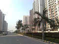 Crossing Republik Ghaziabad (NH 24)
 -
Central Methodist Church Ghaziabad
-
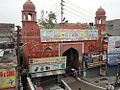 Delhi Gate Ghaziabad
 -
 Raj Nagar Extension (NH-58)
 -
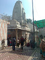 Dudheshwar Nath Mandir (Ghaziabad)

.jpg)

.jpg)
.jpg)
Demographics
The provisional data derived from the 2011 census shows that Ghaziabad urban agglomeration had a population of 4,681,452, of which males were 2,479,710 and females were 2,201,742. The literacy rate was 99 per cent.[33] Ghaziabad is a subcategory B1 district of category B i.e. having socioeconomic parameters below the national average.[34] Among the significant areas within the city are Ghanta Ghar, Bazaria, Chopla Mandir, Maliwara, Model Town, Gandhi Nagar, Nehru Nagar, Kavi Nagar, Raj Nagar, Shastri Nagar, Sanjay Nagar, Ambedkar Road, Navyug Market, Delhi Gate,Goel Market, Mukand Nagar, Sarai Nazar Ali, Rajendra Nagar, Shalimar Garden, Turab Nagar, Indirapuram, Raj Nagar Extension, Loni, India and Crossings Republik.[35]
==Climate==r, As it is connected to the national capital, its temperature and rainfall are similar to Delhi. Rajasthan's dust storms and snowfall in the Himalayas, Kumaon and Garhwal hills name their impact in the weather regularly. The monsoon arrives in the district during the end of the June or the first week of July and normally it rains until October. As in other districts of northern India mainly three seasons - summer, winter and rainy - prevail here, but sometimes due to severe snowfall in the Himalayas and Kumaon Hills, adverse weather can also be seen.
| Climate data for Ghaziabad | |||||||||||||
|---|---|---|---|---|---|---|---|---|---|---|---|---|---|
| Month | Jan | Feb | Mar | Apr | May | Jun | Jul | Aug | Sep | Oct | Nov | Dec | Year |
| Mean daily maximum °C (°F) | 21 (70) |
23 (73) |
29 (84) |
36 (97) |
39 (102) |
38 (100) |
34 (93) |
33 (91) |
34 (93) |
33 (91) |
28 (82) |
23 (73) |
31 (87) |
| Mean daily minimum °C (°F) | 7 (45) |
10 (50) |
15 (59) |
21 (70) |
26 (79) |
28 (82) |
27 (81) |
26 (79) |
24 (75) |
19 (66) |
13 (55) |
8 (46) |
19 (66) |
| Average precipitation mm (inches) | 20.3 (0.80) |
20.3 (0.80) |
15.2 (0.60) |
20.3 (0.80) |
25.4 (1.00) |
71.1 (2.80) |
236.2 (9.30) |
236.2 (9.30) |
114.3 (4.50) |
17.8 (0.70) |
10.2 (0.40) |
10.2 (0.40) |
797.5 (31.4) |
| Source: Ghaziabad Weather | |||||||||||||
Administration
Ghaziabad was given the status of a municipal corporation (nagar nigam) on 31 August 1994.[7] Administratively the city is divided into five areas: the City zone, the Kavi Nagar zone, the Vijay Nagar zone, the Mohan Nagar zone and the Vasundhara zone.[7] Jal Nigam is the prime authority which deals with water supply and sewerage works in Ghaziabad.[36] Ex. Army Chief Vijay Kumar Singh of Bharatiya Janata Party, is the Member of Parliament from the city. He is first elected to this post in 2014 general elections. Assembly Seats which come under Ghaziabad (Lok Sabha constituency) are Loni, India, Muradnagar, Sahibabad, Ghaziabad and Dhaulana.
Economy


Real estate hub
Ghaziabad is a rapid developing city with sky scrapers and malls. The urban areas of Ghaziabad include Indirapuram, Vaishali, Kaushambi, Vasundhra, Surya nagar and the old and richer area with big houses rather than apartment including Kavi nagar and Raj nagar. The first town developed by Britishers in Ghaziabad was Ghantaghar, which is the zero mile stone of Ghaziabad. The plan to expand metro from Dilshad garden to Lal kua has been passed and possibly by 2019 it would be functional and the expansion from vaishali to Mohan nagar via vasundhra is still under talks. the main station of ghaziabad is vijay nagar railway station. A proposal has been made to widen National Highway 24 (NH-24) from six to eight lanes on the stretch between the Ghaziabad-Delhi border and Dasna. As a large number of residential and commercial projects are coming up along the highway.[37] Some major developers which have invested heavily on NH-24 are SARE, Mahagun, Antriksh, Crossings Republik, Ansal, Wave etc. Places on NH-24 and National Highway 58 are flourishing as residential options to the capital because of their proximity to Delhi.[38]
Transport

Ghaziabad can be reached by air, road and rail. The nearest airport is the Indira Gandhi International airport which is about 45 km away. By road, Ghaziabad is well-connected on all sides to Delhi, NOIDA, Hapur, Modinagar, Bulandshahr, Meerut, Baghpat, Saharanpur, Haridwar, etc. A large number of people commute to Delhi, Noida, Greater Noida and Gurgaon every day for work.
- Bus
There are bus terminals at Mohan Nagar, Lohia Nagar, Loni, Vasundhara and close to Meerut Road from where Uttar Pradesh State Road Transport Corporation (UPSRTC) buses serve cities all over the state. The Anand Vihar bus terminal of DTC is located on city's border. There is a bus terminal for private bus operators near ALT Center, Raj Nagar which is called ALT Bus Stand.
- Rail
Ghaziabad is a railway junction and several lines pass through the city. The main railway station is situated in the middle of the city. Apart from Ghaziabad railway station (Station Code-GZB), city also has, New Ghaziabad Railway Station (Station Code-GZN), Sahibabad Railway Station (Station Code-SBB), Mahrauli Railway Station (Station Code-MFH), Adhyatmik Nagar Halt Railway Station (Station Code-AKNR) and Guldhar Railway Station (Station Code-GUH). The city is well connected to Delhi and other neighbouring cities through Fast Moving Local Trains called EMU. Several trains connect Ghaziabad to Meerut, Aligarh, Delhi, New Delhi, Faridabad, Palwal, Mathura, Allahabad, Indore, Ujjain, Loni and others.
- Delhi Metro
The Delhi Metro extends to Dilshad Garden station which is situated at the Apsara Border. At present it serves the areas of Shalimar Garden, Rajendra Nagar and other neighbouring colonies. This line will be further extended to Old Bus Stand, Ghaziabad by 2016-17. Another station exists at Vaishali, which serves that area as well as Vasundhara and Indirapuram, and there is also a station at Kaushambi.[39] There are plans to extend the Blue Line Metro to Indirapuram and loni complete the Blue Line Circle by 2017.[40]
Education
Nearest government college is Gautam Buddha University located in Greater Noida which offers degrees in the field of Engineering,Management,Science and Humanities.Apart from this there are a number of private, post-graduate, law colleges and management institutes in Ghaziabad. Some notable examples are I.T.S Management & IT Institute, Mohan Nagar, ABES Engineering College, Institute of Management Studies,Ghaziabad Institute of Management Technology, Ghaziabad, Ajay Kumar Garg Engineering College, Krishna Institute of Engineering and Technology, Raj Kumar Goel Institute of Technology and Modinagar Institute of Technology.[41]
Schools in Ghaziabad notably include DLF Public School, Sahibabad in Rajendra Nagar, Sahibabad, Delhi Public School, DAV Public School Ghaziabad, Ingraham Institute, DHT SARASWATI VIDYA MANDIR,NEHRU NAGAR Bal Bharati Public School and Ryan International School.
Notable people
- K.C. Tyagi, politician
- Suresh Raina, cricketer
- Donald Crowhurst, British businessman and amateur sailor
- Nikesh Arora, Businessman.
- Lara Dutta, Miss Universe 2000 and Bollywood actress
- Ashmita Chaudhary
Popular culture
Zilla Ghaziabad, a movie released in 2013, is set in the city, and portrays the organised crime and gang wars of the 1980s and early 1990s, which dominated the social backdrop of the city during that period.[citation needed]
References
- ^ "Ghaziabad Nagar Nigam".
- ^ "National Capital Region- Constituent Areas". NCRPB.
- ^ Athique and Hill, Adrian and Douglas. The Multiplex in India: A Cultural Economy of Urban Leisure (2010 ed.). New York. pp. 110–114.
- ^ "District and Sessions Court Ghaziabad- History". NIC.
- ^ "Business:". 17 November 2011. Archived from the original on 20 November 2011.
{{cite web}}: Unknown parameter|deadurl=ignored (|url-status=suggested) (help) - ^ Ghaziabad was first listed in early 2010 as # 420 by size. "The largest cities in the world and their mayors: Cities ranked 301 to 450". City Mayors. Archived from the original on 9 March 2010.
{{cite web}}: Unknown parameter|deadurl=ignored (|url-status=suggested) (help), current listings: "World's fastest growing urban areas (1)". City Mayors. - ^ a b c "Ghaziabad Nagar Nigam: About Us". Archived from the original on 1 February 2013.
{{cite web}}: Unknown parameter|deadurl=ignored (|url-status=suggested) (help) - ^ Vikram, Kumar (16 December 2012). "North News: Gangs of Ghaziabad! When it comes to 'gun power', civilians in Ghaziabad beat cops hands down". India Today. Archived from the original on 16 December 2012.
{{cite web}}: Unknown parameter|deadurl=ignored (|url-status=suggested) (help) - ^ Jahagirdar, Archana (5 July 2006). "Ghaziabad has long way to go". Times Of India. Retrieved 16 April 2013.
- ^ Chakraborty, Tapas (6 August 2012). "20km from Delhi, a 'child kidnap capital'". Calcutta, India: The Telegraph. Retrieved 16 April 2013.
- ^ "The Times of India: Latest News India, World & Business News, Cricket & Sports, Bollywood". The Times Of India.
- ^ a b "district and session court-ghaziabad". Ghaziabad.nic.in. Retrieved 17 June 2014.
- ^ a b c d "Ghaziabad Nagar Nigam". http://www.nagarnigamghaziabad.com/. http://www.nagarnigamghaziabad.com/history.html.
{{cite web}}: External link in|publisher=and|website=|url=(help) - ^ a b "History". ghaziabad.nic.in. District Administration, Ghaziabad.
- ^ "Ghaziabad Nagar Nigam". http://www.nagarnigamghaziabad.com/. http://www.nagarnigamghaziabad.com/history1.html.
{{cite web}}: External link in|publisher=and|website=|url=(help) - ^ Heber, Rt. Rev. Reginald. Narrative of a Journey Through the Upper Provinces of India from Calcutta Bombay, 1824-1825, (With notes upon Ceylon). p. 456.
- ^ a b Roy, Debashish (14 August 2011). "Ghaziabad has a long way to go to become a part of NCR backbone". The Hindu.
- ^ "About Ghaziabad". http://damyantigoel.com/.
{{cite web}}: External link in|website= - ^ a b http://www.nagarnigamghaziabad.com/history1.html
- ^ "[IRFCA] Indian Railways FAQ: IR History: Early Days - 1". Irfca.org. Retrieved 17 June 2014.
- ^ Azimabadi, Badr (2007). Great Personalities in Islam. Daryaganj, Delhi: Adam Publishers. p. 218.
- ^ "[IRFCA] Indian Railways FAQ: IR History: Early Days - 1". Irfca.org. Retrieved 17 June 2014.
- ^ "[IRFCA] Indian Railways FAQ: IR History: Early Days - 2". Irfca.org. Retrieved 17 June 2014.
- ^ Statistical, descriptive and historical account of the North-western ... - North-western provinces - Google Books. Books.google.co.in. 8 June 2007. Retrieved 17 June 2014.
- ^ "1857: The aftermath". Indpaedia. 20 February 2014. Retrieved 17 June 2014.
- ^ Saxena, Aruna (1989). Perspectives in industrial geography : a case study of an industrial city of Uttar Pradesh. New Delhi: Concept Pub. Co. pp. 30, 92, 98. ISBN 8170222508.
- ^ Saxena, Aruna (1989). Perspectives in industrial geography : a case study of an industrial city of Uttar Pradesh. New Delhi: Concept Pub. Co. p. 172. ISBN 8170222508.
- ^ "Mohan Meakin Group". Mohanmeakin.com. Retrieved 17 June 2014.
- ^ Saxena, Aruna (1989). Perspectives in industrial geography : a case study of an industrial city of Uttar Pradesh. New Delhi: Concept Pub. Co. p. 92. ISBN 8170222508.
- ^ Saxena, Aruna (1989). Perspectives in industrial geography : a case study of an industrial city of Uttar Pradesh. New Delhi: Concept Pub. Co. pp. 97, 98. ISBN 8170222508.
- ^ Saxena, Aruna (1989). Perspectives in industrial geography : a case study of an industrial city of Uttar Pradesh. New Delhi: Concept Pub. Co. pp. 124, 93, 11, 39, 69. ISBN 8170222508.
- ^ "district and session court-ghaziabad". Ghaziabad.nic.in. Retrieved 17 June 2014.
- ^ "Urban Agglomerations/Cities having population 1 lakh and above" (PDF). Provisional Population Totals, Census of India 2011. Retrieved 7 July 2012.
- ^ "Meeting of Empowered Committee" (PDF). Minutes of the Meeting Report. Government of India. Retrieved 18 March 2013.
- ^ "Project for widening of 20km stretch on NH-24 scrapped". The Times of India. 29 May 2011.
- ^ Uttar Pradesh Water Supply & Sewerage Act, 1975. "Uttar Pradesh Jal Nigam".
- ^ "Make NH-24 eight-lane to ease mess: Akhilesh Yadav". Hindustan Times. Retrieved 20 June 2013.
- ^ A K Tiwary, ET Bureau 9 September 2011, 08.02am IST (9 September 2011). "Ghaziabad real estate thriving along two national highways - Economic Times". Articles.economictimes.indiatimes.com. Retrieved 20 June 2013.
{{cite news}}: CS1 maint: multiple names: authors list (link) CS1 maint: numeric names: authors list (link) - ^ "Ghaziabad boards Metro for first traffic-free ride to work". Indian Express. 15 July 2011. Retrieved 16 April 2013.
- ^ "Ghaziabad ePaper| Hindi ePaper Ghaziabad- Dainik Jagran". Epaper.jagran.com. 14 February 2011. Retrieved 16 April 2013.
- ^ "Welcome to :: Modinagar Institute of Technology". Miteducation.org. 14 April 2012. Retrieved 17 June 2014.
External links
- Ghaziabad District Administration
 Ghaziabad travel guide from Wikivoyage
- Ghaziabad Photos
- City Mayors Survey
- Uttar Pradesh Assembly Elections
- Ghaziabad Assembly Elections
- Ghaziabad Traffic Police
Template:National Capital Territory of Delhi