
Pilibhit
Pilibhit | |
|---|---|
District HQ | |
| Country | |
| State | Uttar Pradesh |
| Region | Rohilkhand |
| Division | Bareilly |
| District | Pilibhit |
| Ward | 52 wards |
| Settled | Late 15th century |
| Founded by | Hafiz Rahmat Khan |
| Government | |
| • Body | Pilibhit Nagar Palika Parisad |
| • Chairman | Prabhat Jaiswal |
| • MP | Varun Gandhi |
| • MLA | Riyaz Ahmad |
| Area | |
| • Total | 47 km2 (18 sq mi) |
| Elevation | 172 m (564 ft) |
| Population (2011) | |
| • Total | 2,037,225 |
| • Density | 559/km2 (1,450/sq mi) |
| Languages | |
| • Official | Hindi, Urdu, English, Punjabi |
| Time zone | UTC+5:30 (IST) |
| PIN | 262001 |
| Telephone code | 05882 |
| ISO 3166 code | IN-UP-PB |
| Vehicle registration | UP-26 |
| Coastline | 0 kilometres (0 mi) |
| Sex ratio | 889 ♂/♀ |
| Literacy | 63.58% |
| Civic agency | Pilibhit Nagar Palika Parisad |
| Distance from Delhi | 274 kilometres (170 mi) NW (land) |
| Distance from Lucknow | 270 kilometres (170 mi) SE (land) |
| Governing body | Government of UP Government of India |
| Climate | HS-TH (Köppen) |
| Precipitation | 780 millimetres (31 in) |
| Avg. annual temperature | 25.5 °C (77.9 °F) |
| Avg. summer temperature | 36.8 °C (98.2 °F) |
| Avg. winter temperature | 14.5 °C (58.1 °F) |
| The word 'Pilibhit' means "A Wall of Yellow Mud" | |
Pilibhit (historic name: Hafizabad) is a city and a municipal board in the Pilibhit district in the Indian state of Uttar Pradesh. Pilibhit is the north-eastern most district of Bareilly division, situated in the Rohilkhand region of the sub-Himalayan Plateau belt next to foothills of Sivalik Range on the boundary of Nepal, known for the origin of river Gomati and one of the most forest-rich areas in North India. Pilibhit was once known as Hafizabad, derived from the name of the great Rohella leader of the area Hafiz Rahmat Khan, but eventually it took its present name from a nearby village.[1] Pilibhit was also known as Bansuri Nagari - the land of flutes, for making and exporting roughly 95 per cent of India's flutes.[2]
According to a report issued by the Government of India, Pilibhit is one of the Minority Concentrated Areas in India on the basis of the 2001 census data on population, socio-economic indicators and basic amenities indicators.[3] Though separated only by a short distance from the outer ranges of the Himalayas, Pilibhit consists entirely of a level plain, containing depressions but no hills and is intersected by several streams.[4] Pilibhit is one of the forest rich areas of Uttar Pradesh, which has very high tourism potential. The almost 54 km-long Indo-Nepal international border makes Pilibhit a highly sensitive for security purposes.[5] According an estimate by the Government of India, Pilibhit has 45.23% of its population living under the poverty line.[6] Increasing population and unemployment is a cause of worry in the area, and many non-governmental organisations (NGOs) and government-run organizations have initiated projects to provide employment, but human resources are yet to be exploited in full. The city came third-bottom in terms of hygiene and sanitation in a Government ranking list of 423 towns and cities in India.[7]
Pilibhit has been geographic and political cynosure as it is the only forest area amid the 22 districts and the only district that has an international border in Harit Pradesh, which is proposed to be carved out of Uttar Pradesh.
In recent past, Pilibhit has been in news at national level because of a few man killer sub-adult tigers, which has caused fear in the whole area in and around the forest. By August 2010, the cat had killed and partially eaten eight people.[8]
Geography
Pilibhit lies between the parallels of 28°64' and 29°53' north latitude and the meridians of 79°57' and 81°37' east longitude covering an area of 68.76 km2. The north side of Pilibhit is bordered by Udham Singh Nagar of Uttarakhand state and by the territory of Nepal. Shahjahanpur lies on the south side Pilibhit. The east of Pilibhit is flanked for a short distance by Lakhimpur Kheri and the remaining distance is swathed by the Shahjahanpur. The western limit touches the limits of Bareilly.
According to the Central Statistical Organisation, the district Pilibhit had an area of 3504 km2 on September 1, 2007, occupying 46th position in the state and the total area of the Pilibhit city is 68.76 km2. Pilibhit city, with 2365.11 people per square kilometer, is more densely populated that the rest of district, which has 469.51 people per km2.
The area has diverse features, and topographically may be divided into several distinct tracts. In the north and north-west, the tract is a continuation of the Terai. The southern portion of the Bisalpur tehsil is similar in most respect to the adjacent tract of Bareilly and Shahjahanpur. The eastern and smaller section approximates rather to undeveloped forest areas of Lakhimpur Kheri, though with the spread of cultivation the dissimilarity between Puranpur and the rest of the area is gradually becoming less marked. There are 1216 villages within Pilibhit's limits, of which 982 are electrified.[9]

The area has more than ten small to medium sized rivers and nine small to medium sized water bodies. The origin of river Gomti, Gumti or Gomati ([गोमती ] Error: {{Lang-xx}}: text has italic markup (help)), which is a tributary of the Ganges River, is from a small lake, Gomat Taal, situated in Madhotanda in the Puranpur tehsil region.[10] Another important river in the region is River Sharda ([शारदा ] Error: {{Lang-xx}}: text has italic markup (help)), which runs through on the eastern part of the district. Pilibhit city receives water from the river Devhahuti Ganga or Devha ([देवहुति गंगा or देवहा ] Error: {{Lang-xx}}: text has italic markup (help)) on the north-west side of the city and the River Ghaghara or Khakra ([घाघरा or खाकरा ] Error: {{Lang-xx}}: text has italic markup (help)) on the north-east side of the city. Pilibhit city also has a few water bodies in its limits, one being on Tanakpur road in front of Dramond college gate, another being at the Chauraha degree college. Every year during winter, the Chauraha water body attracts thousands of migratory birds. The main source of water in the district is the ground water and the canals. District Pilibhit is swathed by a big net of canals. The district has six main feeders or canals, which run through almost 138 km in the district.

The major part of Pilibhit District is covered by dense forest. Total 784.572 km2 is forest.[11] Till 1978, 63% area of the district was a dense forest, but deforestation has reduced the total forest cover to 22.39% in 2004.[12] The Sharda canal is the main canal of the district, the others being its branches. The total length of canals in the district is 138 km. Apart from the canal system, the district also has a few water bodies, which are being using for agriculture purposes.
National Highway No. 74 runs through the district connecting Haridwar to Bareilly via Kichha, Kashipur and Nagina city. Apart from the National Highway, the district is well connected with Shahjahanpur in south, Lakhimpur Kheri and Indian International Border (IIB) with the Nepal in east, Nanital and town Khatima in north, and the city of Bareilly in the west by roads and railways. There are 1216 Villages in the district Pilibhit in four tehsils and seven blocks.
The district Pilibhit also has several places of religious importance in or around the district. A main gurudwara of the Sikh community is located in Nanakmatta town around 46 km from the city.[13][14]
One of the biggest and the most important temples of the region, Sri Purnagiri Temple, is in the nearby Champawat district of Uttaranchal. Millions of people from around Uttar Pradesh and other parts of Northern India come to this temple, and Pilibhit is one of the halting points for the pilgrims.[15]
Demographics
As of the 2011 India census,[16] District Pilibhit had a population of 2,037,225. Pilibhit district is the 46th most populous Districts of Uttar Pradesh. Pilibhit City has 1,97,455 people. Males constitute 52.94% of the population and females 47.06%. Pilibhit has an average literacy rate of 63.58%, lower than the national average of 74.04%. Male literacy is 73.46%, and female literacy is 52.43%. In Pilibhit, 14.58% of the population is under 6 years of age.[17]

Prior to the abolition of zamindari, the zamindars owned large tracts of arable and forest land. Farm labors were brought from eastern Uttar Pradesh and Bihar. After zamindari was abolished, the excess cultivable land was distributed amongst the landless agricultural labors. In the post-independence period, many displaced persons from Pakistan were settled in the area. They were provided cultivable land mainly by clearing private forests. Large tracts were cleared and wetlands were drained and brought under the plough. The inhabitants of the land generally belong to these major groups: those from eastern Uttar Pradesh, those from Pakistan including Punjabis and Bengalis, migrants from Punjab and the locals. The common property lands and resources are worst affected in Puranpur tehsil. The population density of the tehsil has increased considerably over the last two decades. The population groups constantly endeavor to maintain their interests and identity. The immigrant labour and the Bengalis are the weakest economically but have growing political clout. The Punjabi displaced persons and migrants are financially the strongest and wield considerable political clout.[18]
One of the historically important community is the Tharu tribe.[19]
- Population Growth Estimation in next 40 years in Pilibhit [21]
| Year | Estimated Poulation | Growth Percentage |
|---|---|---|
Studies reveal that the poverty level in the district is associated with the social identity, source of livelihood, landless and level of education of the head of household. Education is a crucial instrument for raising income levels of people and moving out of the vicious circle of poverty. A study done by Delhi-based NGO, Nav Bharat Nirman indicates a strong correlation between educational attainment and poverty levels among various social classes in the district. The incidence of poverty is much higher among scheduled castes (SC) and scheduled tribes (ST) households in Pilibhit. Nearly 60 per cent of SC households were below the poverty line in Pilibhit in 1999-2000. However, this proportion came down to 45.23 per cent in 2007-08.[22] The pace of decline of poverty was faster for the SC/ST households as compared to other households during this period. The poverty level among Hindus and Muslims was roughly of the same in the rural areas around 31 percent in 1999-2000. But poverty levels are much higher for Muslims in the urban areas, which is almost equal to 42.2 per cent as compared to only 26.4 per cent for Hindus. With 7,44,120 people under poverty line, Pilibhit comes under top 20 backward districts of India in term of education, socio-economic conditions, opportunity to earn livelihood and basic amenities. Many non-profit organization have come forward to help the population living under the poverty line.
Climate
Pilibhit experiences three distinct seasons: summer, monsoon and winter. The typical summer months are from the end of March to June, with maximum temperatures ranging from 36 °C (97 °F) to 42 °C (108 °F). Contrary to most of the Himalayan Plateau where June is the warmest month, the warmest month in Pilibhit is May. The city starts receiving heavy thundershowers with sharp downpours in mid June. Though the temperatures plunge in this month, the summer heat can be accompanied by high humidity.
Monsoon winds blowing from the south India are a welcome relief in mid June, bringing with them heavy showers in July and August. Pilibhit receives considerable rainfall in August and September. The city receives an annual rainfall of 723 mm, mainly between June and September as the result of southwest monsoon. August is the wettest month of the year. The spells of continuous rainfall may stretch to many days or even a few weeks. In 1967, Pilibhit received a record of 17 consecutive days of rainfall (days when rainfall is greater than 21.7 mm).
As the monsoon winds recede, the day temperature starts to decline in October with cooler nights signalling the onset of winter. Pilibhit experiences winter from November to February. It experiences pleasant windy days, clear skies and cool nights from November to the end of February, which makes it the most enjoyable time of the year. The day temperature hovers around 14 °C (57 °F) while night temperature is below 7 °C (45 °F) for most of December and January, often dropping to 3 °C (37 °F) or 4 °C (39 °F). On particularly cold days, wind may appear to be very chilly due to the dryness of air. Rain is very expected in February.[23]
Reported climatic variations:[24]
- The highest temperature recorded in Pilibhit was 48.5 °C (119 °F) on 29 May 1989.
- The lowest temperature recorded in Pilibhit was −0.2 °C (32 °F) on 17 January 1949.
- Pilibhit received snowfall once, in January 1949, which was the coolest year in the Himalayan Plateau region. The temperature reached below zero this year in the region.
| Climate data for Pilibhit, Uttar Pradesh, India | |||||||||||||
|---|---|---|---|---|---|---|---|---|---|---|---|---|---|
| Month | Jan | Feb | Mar | Apr | May | Jun | Jul | Aug | Sep | Oct | Nov | Dec | Year |
| Mean daily maximum °C | 14 | 19 | 21 | 36 | 40 | 42 | 40 | 36 | 34 | 29 | 20 | 11 | 29 |
| Mean daily minimum °C | 4 | 10 | 13 | 23 | 31 | 34 | 32 | 27 | 24 | 20 | 13 | 6 | 20 |
| Average rainfall mm | 7.6 | 23 | 30 | 46 | 81 | 120 | 130 | 140 | 110 | 30 | 23 | 13 | 753.6 |
| Mean daily maximum °F | 57 | 66 | 70 | 97 | 104 | 108 | 104 | 97 | 93 | 84 | 68 | 52 | 83 |
| Mean daily minimum °F | 39 | 50 | 55 | 73 | 88 | 93 | 90 | 81 | 75 | 68 | 55 | 43 | 68 |
| Average rainfall inches | 0.3 | 0.9 | 1.2 | 1.8 | 3.2 | 4.8 | 5.2 | 5.5 | 4.3 | 1.2 | 0.9 | 0.5 | 29.8 |
| Source: www.wunderground.com[25] | |||||||||||||
Etymology
The city Pilibhit derived its name from a nearby small village name 'Old Pilibhit', whose existence has been traced to the mid-15th century. This village still exist on the bank of the River Ghaghra or Khakra in the north-east from the city on the way to Nyoria Husainpur town. This village was occupied by the Bhanjara (local community) of the Periya clan, which used to live in the houses made of mud and other raw material available in the forest. This community made a wall or mound of yellow mud around their locality in order to secure their house from wild animals, as that area was a dense forest, so the people used to call the locality as Pili (yellow) and Bhit (wall or mound). According to the Imperial Gazetteer of India, vol. 20, page 144, issued by the Government of India, Pilibhit was once known as Hafizabad on the name of the great Rohella leader of the area, Hafiz Rahmat Khan, but later took its current name from a nearby village.[26] According to a document from the British Library, 'the city Pilibhit' existed in the late 18th century (1770–1780) when Marathas invaded the Rohilkhand region. With this invasion, the Kurmi community came to this region and over time, the city Pilibhit enlarged it boundaries.[27] Another evidence of the city's existence is found in Nepali literature, which mentions a city named as Pilibhit, which provided shelter to the last king of the Shah dynasty, Deepa Shah, who was attacked by the Gorakha king in 1789 AD.[28] The Rohella ruler Hafiz Rahmat Khan, a Pashtun ancestor of Afghans in the area, developed Pilibhit as a city and administrative unit.
History

The city Pilibhit was an administrative unit in the Mughal era under Bareilly suba. For security, the Mughal subedar Ali Mohammed Khan constructed four magnificent gates around the administrative building in 1734 AD. These gates were named Barellwi darwaza at the west, Hussaini darwaza at the east, Jahanabadi darwaza at the north and Dakhini darwaza at the south. Because of a lack of proper maintenance, all the gates have been lost; only their ruins remain.[29]
The last king of the Raika dynasty of Doti ( Nepal ) , King Prithivipati Shah, was sheltered in Pilibhit by the ruler of Rampur suba Faizullah Khan in 1789 AD, after being attacked by the Gorakha king of Nepal.[30]
At the introduction of the British rule, the parganas of Pilibhit, Jahanabad and Bisalpur was formed into separate tehsils. Puranpur was united for this purpose with Khutar. A redistribution of the area was effected in 1824, when the Bisalpur tehsil contained the parganas of Bisalpur and Maurari, which afterward become a single area, Jahanabad was joined with Richha to form tehsil Pareva and Pilibhit with Baheri, the HQ being at Pilibhit. In 1851 Baheri and the other tarai pargana were taken under direct management and in 1863 Richha was attached to the new Baheri tehsil, pargana Jahanabad being assigned to Pilibhit which also received Puranpur on its transfer in 1865. The latter, in 1871, a became subtehsil dependent on Pilibhit. The promotion of Puranpur into a full tehsil occurred in 1879, while Bisalpur throughout remained a separate subdivision. Thus the area is now divided into three tehsils and four parganas. Puranpur and Bisalpur constitute individual tehsils and parganas and the tehsil of Pilibhit comprises the paraganas of Pilibhit and Jahanabad.[31]
Riots and clashes
Due to dense minority population, Pilibhit district is a communally sensitive area. Pilibhit also has seen many riots and communal clashes.
| Year | communal Riots/Clashes | Reason | Casualties-Officially |
|---|---|---|---|
| Hindu-Muslim communal clash | Moharram and Ram navami festivals on same day[32][33] | ||
| Hindu-Muslim communal riots | Hindu protest against cow slaughter on Baqrid[34] | ||
| Hindu-Muslim communal riots | Cow slaughter by Muslims on Baqrid[35] | ||
| Hindu-Muslim communal clash | Trouble at the Ram navami festival procession[36] | ||
| Hindu-Muslims communal cum political riots | Hindu groups accused Muslims to want to turn UP as Muslim state[37] | ||
| Hindu-Muslims political riots | RSS-Muslim League clash turned communal riots[38] | ||
| Communal riots provoked by Hindu group | Hindu group RSS tried to frustrate Muslims in area to leave India[39] | ||
| Muslim attack on Hindus tuned into riots | Muslim protested Ram navami procession in Muslim areas[40] | ||
| Hindu-Muslim communal clash | Hindu boy was attacked by Muslim boys in Moradabad[41][42] | ||
| Hindu-Sikh political riots | Sikh massacre after Indira Gandhi's assassination[citation needed] | ||
| Hindu-Muslim communal riots | Ayodhya aftermath[43] | ||
| Political unrest over Varun Gandhi's remark | Mass clashes between Varun Gandhi's supporters and administrative forces[44] | ||
| Unrest in Sikh community because of desecration of Guru Granth Sahib | Against the insult of the holy book in Katia Patti an adjoining town near Majhola.[45] |
Human life loss due to natural calamities
Famine -
- A great famine in 1877-78, followed by fever epidemic in 1879 caused almost 41000 of deaths in the area of Pilibhit, Puranpur, Bisalpur.[46]
Disease' -
- Almost 2,73,362 people died in 1911-21 due to various epidemics such as Plague, Cholera, Smallpox, Yellow Fever, Gastroenteritis in this area, due to which population growth during 1911-21 was negative.[47][48]
| Year | Plague | Cholera | Smallpox | Fever | Gastro-Enteritis | Total |
|---|---|---|---|---|---|---|
Flood -
- Pilibhit comes under the High Risk Flood Zone. Almost every year some part of district is affected by massive floods.[49] but the city has seen disastrous floods and massive distraction due to flood, thrice in last fifty years, in July 1971,[50] Sept 1989 and Sept 2008.[51][52]
- More than Rupees 15 millions worth of damage and more than 43 human casualties had been reported by the government sources during the flood in September 2008 in the district Pilibhit. Puranpur tehshil was the worst hit by the flood.
- Pilibhit again saw devastation of flood in 2010, two school buildings were washed away by the floods and Two persons were reported to be missing from the Devha river bridge. A number of villages in trans-Sharda area in Pilibhit had been affected by these floods.[53]
- The lower areas of Pilibhit city, faced flood situation after two days of continuous raining in August 2011, District administration raised alarm to the public to go to safe places.[54]
Seismic History -
- Pilibhit comes under seismic zone-4,[55] which is a High Risk Seismic Zone. According to Government of India, Pilibhit town is considered to be top 30 cities in the country that fall into high risk seismic zone.[56] Pilibhit has been trembled a few times in past two centuries as below:-.[57]
| Date | Epicenter | Strength on Richter scale |
|---|---|---|
| 1 September 1803 | Northern Garhwal region | |
| 10 October 1956 | Bulandshahr district | |
| 24 December 1961 | Northern Garhwal region | |
| 15 September 1966 | South of Moradabad district | |
| 29 July 1980 | Western Nepal region | |
| 29 March 1999 | Northern Garhwal region | |
| 18 October 2007 | District Gautam Buddha Nagar region | |
| 4 April 2011[58] | District Pithoragarh region |
Transportation
Rail transportation
Pilibhit junction railway station is on the Bareilly-Lakhimpur railway line. The station is under the administrative control of the North Eastern Railways. Computerized reservation facility is provided. Going south-west, Bhojipura junction railway station is the main station next to Pilibhit. The nearest main station to the west is Puranpur railway station.[59]

Three express trains come here from Lucknow: Lucknow-Agra express (5313), Nainital Express (5308) and Rohilkhand Express (5310). Two express trains come from Agra: Agra-Gonda express (5316) and Agra-Lucknow (5314) Express. From Delhi one has to reach first nearby district Bareilly by bus or train before reaching Pilibhit by a bus or meter gauge train.[60]
Pilibhit expected to be connected by meter gauge to Lucknow through Bareilly-Lakhimpur railway line by the end of 2012.[61]
- Station Code: PBE
- Enquiry about arrival and departure of trains: +91-5882-255804
Road transportation
National Highway 74 passes through Pilibhit. Regular buses connect Pilibhit to Bareilly at the frequency of every ½ hr. Direct buses are also available from Delhi, Lucknow, Haridwar, Rishikesh, Kanpur, Rupaidhiya, Agra and Tanakpur, etc.
- Enquiry about arrival and departure of buses: +91-5882-255670
Air transportation
Nearby airports (within 200 miles):-
| Nearest Airport | Symbol | Distance (In miles) |
|---|---|---|
Main roads in city
| No. | Names of Road |
|---|---|
| 1. | Station Road |
| 2. | Jai Prakash Road |
| 3. | Nai Basti Road or Degree College Road |
| 4. | Chudi wali Gali |
| 5. | Thandi Road or Katchari Road |
| 6. | Mill Road |
| 7. | Khakra Road |
| 8. | Assam Road |
| 9. | Gandhi Stadium Road |
| 10. | Jaisantri Road |
Wildlife

Pilibhit Tiger Reserve
Pilibhit has been granted to have a tiger reserve area which constitutes potential tiger habitat of priority I and II. This new tiger reserve at Pilibhit covers an area of approximately 1087 km² in Lagga Bhagga Forest Range. It runs through Pilibhit, Kishanpur Wildlife Sanctuary and Khutar range of Shahjahanpur, the existing one has Dudhwa, Katarniaghat and Kakraha range of Bahraich division.[62] Pilibhit, Khutar and Kakraha are the reserved forest areas which are being converted into protected areas for the reserves. This reserve is sectioned under the much talked program "Project Tiger".[63] The February 2008 annual census of forest inhabitants says that this reserve area has a total 36 tigers: 11 male, 20 female, and five cubs. In the 2005 census, there were only one cub, 12 males and 22 females in the district. Pilibhit reserve has been expanded to over 73,000 hectares in several districts.[64]
The massive deforestation in the only existing forest tract of Indo-Nepal border in Pilibhit-Lakhimpur Tarai belt has reduced the forest cover. The depleted swathes of forest land have increased the pressure on survival of wild animals within the protected area. The new tiger reserve was sanctioned in keeping with this problem.[65] The outline for the reserve, as identified by the Critical Tiger Habitat Committee, has approved by Central government in September 2008. With Pilibhit Tiger Reserve area, Uttar Pradesh has two tiger reserve areas.[66] The Government of India has opened four reserves: Sunabeda Tiger Reserve in Orissa, Shahayadri Tiger Reserve in Maharashtra, Pilibhit Tiger Reserve in Uttar Pradesh, and Ratapani Tiger Reserve in Madhya Pradesh in the third quarter of 2008.[67]
The fishery reservoir
Pilibhit also has a fishery reservoir, which is situated in the tehsil Bisalpur. It is recognized as a reservoir by Fisheries Department of the state government and by the central government. The State Fisheries Department classifies this water body used as a medium-size fishery reservoir (500 to 1000 ha area). This reservoir is a natural water body located on the southern periphery of Deoriya range also runs along the forests of this range. Every year during winter, this water body attracts thousands of migratory birds. Besides birds, it is home to a large number of turtles and numerous species of fish. Pilibhit also has a few small man-made and natural water bodies which are being use by Fisheries Department. There are also large numbers of local communities, mainly refugees from East Bengal settled on periphery of this water body. These communities engage themselves in poaching of migratory birds every year disturbing the peace and tranquility.[68]
Other forest area in Pilibhit
Apart from the reserve area and wild life places, Pilibhit also has a few forest areas around in the district including: Mala range (east from city towards Puranpur), Haripur range (east from the Puranpur town towards Nepal border), Barahi range (a few kilometres from city towards Kalinagar), Mahof Range (east from city near to Nyoria Husainpur)[69] and Deoriya range (on district's southern-east border towards Shahjahanpur). Mala, Deoriya and Barahi are well-connected with the city by road and railway. Mala range comes on the way to Lakhimpur Kheri from Pilibhit city, which is famous for leopards, swamp deer,[70] Rhinoceros, Cheetal, hog deer, barking deer, sambar, Wild bear, ratel, and around 400 species of birds and 90 species of fishes. Some of them are really dense and uninhabited areas. Mala and Deoriya has a few inhabited colonies, but Mahof is completely uninhabited yet., A part of this forest range, including area from forest in Udham Singh Nagar district of Uttarakhand, is also known as Lagga-Bagga forest range, which makes the Nepal border along with the River Sharda and "no man's land". In Mala and Barahi forests, Bengali communities are living in small colonies. They came to the area from East Bengal after the partition of India in 1947. After refugee settlement started in the area in 1947, deforestation had become a major concern.
Sports
Sri Lalit Hari Cricket Stadium
Pilibhit has one cricket stadium in the Shri Lalit Hari sugar mill compound, which is formerly known as Lalit Hari Stadium. This stadium was established in 1931 on Tarakpur road, at the railway station end. The home team for this stadium is Uttar Pradesh. It has matting type of pitch. This stadium had hosted a few Ranji trophy cricket matches in the early 1980s.
A New Cricket ground namely "LALIT HARI STADIUM' was made by the Raja Family in its Sugar factory campus in the year 2010with indoor and outdoor games facilities . 2010 was the Centinary year of sugar factory and stadium was the one project among others undertaken dedicated in the memory of Raja Lalta Prasad and Sahu Har Pradad by the Raja Family.
Some of the famous match was played at the Lalit Hari Sugar Factory Ground, Pilibhit are:
- A match played between Uttar Pradesh and Rajasthan teams, a north zone match on 25, 26, 27 December 1983 (three-day match) under 1983/84 Ranji trophy cricket tournament. Uttar Pradesh won the toss and decided to bat, but the match was drawn.[71]
- A match played between Uttar Pradesh and Vidarbha teams, a Central Zone match on 22, 23, 24 November 1981 (3-day match) under 1981/82 Ranji trophy cricket tournament. Vidarbha won the toss and decided to bat but Uttar Pradesh won the match by 8 wickets.[72]
Gandhi Sports Stadium
This stadium in the Bareilly zone covers 85 acres (local measurement) of area in the middle of the city, which has various facilities for athletics, football, volleyball, hockey and some indoor sports. A swimming pool is proposed to be constructed in the stadium. In the same compound one multipurpose auditorium is available. This stadium is the only sports facility available for public uses.
Other facilities
Various educational institutions have their own facilities, including: DGIC ground, St. Aloysius ground, Rama college ground, and SVM college ground. The city hasn't produced any big sports celebrities, but city teams have won a few state level competitions on various events.[73]
Education


The city of Pilibhit has several secondary and higher secondary schools and colleges for boys and girls. One of the main Ayurvedic colleges of Uttar Pradesh is situated in the city. The city has one ITI college, one law college, one nursing college and one management school, and a few colleges for science, commerce and art. The educational institutions are the main attraction for the students of nearby places as many new institutions have come up in the city for various higher education mainly affiliated with MJP Rohilkhand University, Bareilly.
Main educational institutes in Pilibhit
| No. | Names of Educational Institutes | Affiliation With |
|---|---|---|
| 1. | Drumand Boys' Government Intermediate College | UP Board, Allahabad |
| 2. | St. Aloysius Intermediate College | CBSE Board, New Delhi |
| 3. | Chironji Lal Virendera Pal Saraswati Vidhya Mandir Boys' Intermediate College[74] | UP Board, Allahabad |
| 5. | Springdale Intermediate College | CBSE Board, New Delhi |
| 6. | Sanatan Dharam Banke Bhihari Shri Ram Boys' Intermediate College | UP Board, Allahabad |
| 7. | Lions Bal Vidhya Mandir Intermediate College | CBSE Board, New Delhi |
| 8. | Girls' Government Intermediate College | UP Board, Allahabad |
| 9. | Anguri Devi Saraswati Vidhya Mandir Girls' Intermediate College | UP Board, Allahabad |
| 10. | Siddique National Boys' Intermediate College | UP Board, Allahabad |
| 11. | Ben-Hur Intermediate College | CBSE Board, New Delhi |
| 12. | Upadhi Mahavidhayalaya | Rohilkhand University, Bareilly |
| 13. | Ram Lubhai Sahani Govt. Girls' Degree College | Rohilkhand University, Bareilly |
| 14. | Pushp Institute of Sciences & Higher Studies[75] | Rohilkhand University, Bareilly |
| 15. | Hafiz Rahmat Khan Law College[76] | Rohilkhand University, Bareilly |
| 15. | Sanjay Gandhi School of Nursing | Rohilkhand University, Bareilly |
| 16. | Shri Lalit Hari Sanskrit Mahavidhiyalaya | Sampurnanand Sanskrit University, Varanasi |
| 17. | Springdale College of Management Studies[77] | Rohilkhand University, Bareilly |
| 18. | Little Angels School | CBSE Board, New Delhi |
Economy
Industry and agriculture

The district Pilibhit has an agriculture-based economy. It has very fertile land, but little industry, and has no mineral extraction area. The industry in the district is mainly based on agriculture. Since the main crop in this area is sugarcane, there are four sugar factories at Majhola, Puranpur, Bisalpur and Pilibhit. Three factories are in co-operative sector and one at Pilibhit is in private sector. The Lalit Hari Sugar Factory is the largest among them. In 2005-06, the Bajaj Industry opened with Bajaj Hindustan Sugar Factory Ltd, in Barkhera area of the district. The district also has a few cottage industries, including wooden or bamboo flute manufacturing, engineering units, brick klins, candles and zari work. The flutes made in Pilibhit have a big international demand. These flutes are exported to the United States, Europe, Japan, Canada, UAE and African countries. Other major units are three solvent plants, four flour mills, one steel plant (a few kilometres from the city) and one alcohol distillery in Majhola town. According to an article published in Hindustan Times, by a 1991 estimate, 95% of India's flutes were manufectured in Pilibhit.[78] The craftmen were used to source its bamboo from Barak Valley in Assam. Earlier, there was an unbroken narrow-gauge line running from Silchar, in Assam, via Bihar, and into Pilibhit. On this line, 60-strong bundles of bamboo, each stalk 10 ft long, used to make their way to Pilibhit, but around 15 years ago, sections of that line were removed. Now, the bamboo has to travel on narrow gauge from Silchar to Jiribum, then shift onto a broad-gauge line to travel to Bareilly, the nearest big town, and then reloaded onto narrow gauge to come into Pilibhit.[79]
The main crops of Pilibhit are sugarcane, rice, wheat, pulse, food grains, mustard and oil seeds, which depend upon the seasons. District Pilibhit supplies a large amount of fresh vegetables to Delhi, Lucknow and nearby markets in Uttaranchal. Pilibhit has one of the biggest food grain market in the Uttar Pradesh named as Adarsh Krishi Khadyann Mandi Samiti ([आदर्श कृषि खाद्यान्न मण्डी समिति] Error: {{Lang-xx}}: text has italic markup (help)), which is the main supplier market food grain and vegetable to Uttaranchal.
The dairy industry has been flourished in the area. The district has a lot of livestock, mainly cows, buffalos, goats. The district fulfills its own demand, and supplies the district of Bareilly and various places in Uttaranchal.
The embroidery industry is also one of the major source of income for semi-skilled labor. With help of some NGOs, this industry is growing in the local market, but and at the international level.
- Economic development indicators[80]
| Indicators | 2004 | 2008 | 2012 |
|---|---|---|---|
| Work Participation Rate | |||
| No. of Branches of Scheduled Commercial Bank | |||
| Habitations connected to pucca roads | |||
| Electrified Households | |||
| Houses with land-line connections | |||
| Avg Annual Per Capita Income | |||
| Per Capita Expenditure | |||
| Inflation Index |
Politics
Lok Sabha Constituency
Pilibhit parliamentary constituency has been a favorite for the candidates who don't belong to the constituency itself. Only three times has a local candidate won the seat. After Independence, in the first general election, a local candidate Mukund Lal Agrawal won the seat as the Indian National Congress candidate and made it to Parliament. The Lohiya wave in 1977 and Ayodhya wave in 1991 helped local candidates win the seat. After Agrawal, a Praja Socialist Party candidate, Mohan Swarup, who was from Bareilly, won three consecutive general elections in 1957, 1962 and 1967. In the 1971 general election, Mohan Swarup won the Pilibhit seat as the Indian National Congress candidate.[81]
In the 1977 general election, the Nawab of district's Sherpur Riyasat, Md Shamsul Hasan Khan won the constituency. But in the every next general election in 1980, he lost the seat and Indian National Congress's candidate, Harish Kumar Gangawar, who belong to Bareilly, won the election from Pilibhit parliamentary constituency. And after that, in the 1984 general election, Indian National Congress's candidate Bhanu Pratap Singh, who belong to Bareilly who the election from the seat. Then it was Menaka Gandhi's turn to win the Pilibhit parliamentary constituency] as the Janata Dalcandidate. She belongs to Nehru-Gandhi family and is widow of Sanjay Gandhi. But 1991's Ayodhya wave, helped the Bharatiya Janata Party (BJP) candidate and prominent politician from Barkhera Parshuram Gangwar to reach the Parliament after defeating her. Again in 1996 Menaka Gandhi won the general election as Janata Dal's candidate. She won next two general elections in 1998 and 1999 as an independent candidate, but supported by Bharatiya Janata Party. In 2004, she formally joined BJP and won Pilibhit parliamentary constituency seat as BJP's candidate. For 15th parliamentary election, she vacated the seat for her son Varun Gandhi.[82]
Pilibhit was in news in March 2009, just two months before the general election of 2009, because BJP candidate Varun Gandhi had made some communal remarks in a public meeting in Dalchand locality of the city on March 6, 2009 and surrendered before the local court in Pilibhit. After his anticipatory bail expired in the presence of a large number of supporters on 29 March 2009, there were mass clashes between Varun Gandhi's supporters and administrative forces in the city.[83][84][85][86]
The Pilibhit parliamentary constituency seat recorded a voter turnout of 64.37 per cent in the 2009 Indian general election. This was the highest turnout in Uttar Pradesh[87]< Varun Gandhi won and all fifteen other candidates lost their security deposits.[88]
Vidhan Sabha constituencies
Culture
Festivals
Religious practices are as much an integral part of everyday life and a very public affair as they are in the rest of India. Therefore not surprisingly, many festivals are religious in origin although several of them are celebrated irrespective of caste and creed. Among the most important Hindu festivals are Diwali, Holi and Vijayadashami, Mahashivaratri, Ram Navmi, Basant Panchami, Sri Krishna Janamastmi and Raksha Bandhan,which are also observed by Jains and Sikhs. Eid al-Milad, Eid ul-Fitr, Bakr-Id and Moharram are Muslim religious festivals. Mahavir Jayanti is celebrated by Jains, Buddha Jayanti by Buddhists, Guru Nanak Jayanti by Sikhs and Good Friday, Christmas by the Christians.[89]
Communication and media
- Communication networks
All prominent tele-communication network provider in India offer their services in Pilibhit. The city of Pilibhit falls in the eastern boundary of Uttar Pradesh West telecom circle and thus calls from city of Pilibhit to neighboring districts including rest of the area in the western Uttar Pradesh and Uttarakhand telecom circle are considered to be local so they charge lower rates than call going to eastern part of Uttar Pradesh.
- Radio services
Radio services available in Pilibhit:
| Service Provider | Frequency |
|---|---|
- Print media
The Hindi daily news papers include Dainik Jagran, Amar Ujala, and The Hindustan. Prominent English dailies like The Times of India, The Hindustan Times and Indian Express have fewer readers. Among lesser know Hindi papers are Swatantra Bharat, Rashtriya Sahara, and Jansatta. The Hindi newspapers Dainik Jagran and Amar Ujala have their offices in the city.
Civic administration
The Pilibhit Nagar Palika Parishad (PNPP) is the largest municipal board in the Pilibhit District, in charge of the civic and infrastructural assets of the city of Pilibhit. This municipal board was established in 1865.[90] Municipal limits begin with bank of River Khakra in the north, to bank of river Devha in the south and railway colony in the east to civil court in the east. The PNPP comprises 52 elected representatives, called Ward Members, one from each of the 52 wards (civic units) of the city. Elections to the Nagar Palika are held once every five years, with results being decided by popular vote. A ward member from the majority party is selected as a Palika Chairman, which is equivalent to Mayor in municipal corporations. The headquarters of Pilibhit Nagar Palika Parishad is at Sugar Mil Road. As of 2007, the Pilibhit Nagar Palika covers an area of 68.76 km² (27 sq mi).
Gallery
-
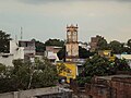 The clock tower (Ghanta Ghar) in the main market, Pilibhit
 -
 Chhathavi Padshahi Gurudwara as on July 2012 in Pilibhit
 -
 The other Gate of Sri Gauri Shankar Temple, Pilibhit
 -
 The Main Gate of Sri Gauri Shankar Temple, Pilibhit
 -
 The entry gate at the eastern side of Sri Gauri Shankar Temple, Pilibhit, which were built by Hafiz Rahmat Khan in late 18th century
 -
 Compound Sri Gauri Shankar Temple, Pilibhit
 -
 The entry gate at the southern side of Sri Gauri Shankar Temple, Pilibhit, which were built by Hafiz Rahmat Khan in late 18th century
 -
 Jamia Masjid Main entrance
 -
 Sri Radha Krishna Temple, Pilibhit
 -
 Methodist Church, Pilibhit
 -
 Shah Ji Miyan Dargah Compound
 -
 Gurudwara Sri Chhatwi Padshahi in city of Pilibhit
 -
 New Sai Baba Temple in city of Pilibhit
 -
 Interior of Sai Baba Temple situated in city of Pilibhit
 -
 Sarada Canal Pilibhit
 -
 Sarada Canal in Banbasa near Pilibhit
 -
 The Mighty Sarada Canal near Pilibhit
 -
 Nanak Sagar Dam near Pilibhit


See also
- Related pages about Pilibhit
- Article about places in Pilibhit
- Article about people from Pilibhit
Further reading
- P. C. Kanjilal, P (1982). "A Forest Flora for Pilibhit, Oudh, Gorakhpur, and Bundelkhand" (Document). Narendra Pub. House.
{{cite document}}: Unknown parameter|edition=ignored (help) - Basil Leonard Clyde Johnson, P (1979). India,: Resources and Development (6 ed.). Heinemann Educational Books. ISBN 0-06-493348-2.
- Govt. of Uttar Pradesh, P (1959). "Uttar Pradesh District Gazetteers" (Document). Govt. of Uttar Pradesh.
{{cite document}}: Unknown parameter|edition=ignored (help) - Walter C. Neale, P (1962). "Economic Change in Rural India: Land Tenure and Reform in Uttar Pradesh:1800-1955" (Document). Yale University Press.
{{cite document}}: Unknown parameter|edition=ignored (help) - Ira Klein, P (1974). "Population and Agriculture in Northern India, 1872-1921" (Document). Cambridge University Press.
{{cite document}}: Unknown parameter|edition=ignored (help)
Citations
- ^ "Pilibhit as Hafizabad". Government of India. Retrieved 12 May 2009.
- ^ "Pilibhit as Bansuri Nagari". The Indian Express. Retrieved 24 January 2010.
- ^ "Minority Concentrated Districts". Government of India. Retrieved 19 December 2007.
- ^ "The Physical Aspects". Government of India. Retrieved 4 October 2009.
- ^ "Indo Nepal International Border". The Dainik Jagram, Hindi News Paper. Retrieved 25 April 2009.
- ^ "Population under poverty line". A N Sinha Institute of Social Studies. Retrieved 21 July 2007. [dead link]
- ^ Government of India, National Urban Sanitation Policy
- ^ "Man Eating Tiger". Time Of India, English News Paper. 28 August 2010. Retrieved 29 August 2010.
- ^ "Electrified Villages in Pilibhit". Uttar Pradesh Power Corporation Limited. Retrieved 24 January 2010.
- ^ Dikshit, Rajeev (25 August 2006). "Gomati goes missing". The Times of India. Retrieved 25 August 2006.
- ^ "Forest in Pilibhit". District Administration. Retrieved 3 December 2006.
- ^ "Pilibhit Wildlife". SEVAK group, India. Retrieved 23 April 2007.
- ^ "Historic Gurdwara". Punjab Heritage. Retrieved 9 December 2008. [dead link]
- ^ "Nanak Matta Sahib". Uttarakhand Tourism. Retrieved 12 September 2006.
- ^ "Purnagiri Temple". Uttarakhand Tourism. Retrieved 16 November 2007.
- ^ "Population of Pilibhit" (PDF). National Register of Indian Citizens. Retrieved 7 May 2011.
- ^ "The Literacy rate in 2011" (PDF). Government of India. Retrieved 7 May 2011.
- ^ "Demography of Pilibhit". All India Pingalwara Charitable Society (Regd.). Retrieved 8 May 2006.
- ^ "Historical Community of India". Retrieved 29 August 2007.
- ^ "Religion in Pilibhit" (PDF). a study done by Bharat Sanchar Nigam. Retrieved 19 May 2009.
- ^ "Population Growth Estimation in next 40 years in Pilibhit" (PDF). International Water Management Institute (IWMI). Retrieved 7 May 2011.
- ^ "Population Under Poverty Line". A N Sinha Institute of Social Studies. Retrieved 21 July 2007. [dead link]
- ^ "Annual Weather Pilibhit". Weather Underground. Retrieved 22 October 2006.
- ^ "Climatic Variations in Pilibhit". Indian Meteorological Department. Retrieved 21 March 2005.
- ^ "Pilibhit weather". Weather Underground. Retrieved 4 February 2008.
- ^ "Pilibhit known as Hafizabad before 1763". Government of India. Retrieved 12 May 2009.
- ^ "History of Banjaras". Prof Motiraj Rathod. Retrieved 15 July 2008.
- ^ "Advanced History of Nepal". T.R. Vaidya Publications. Retrieved 20 January 2005.
- ^ "Ruin of Pilibhit". Brill's Indological Library, Leiden: E.J. Brill. Retrieved 10 November 2007.
- ^ "History of Nepal". T.R.Vaidya Publications. Retrieved 31 January 2008.
- ^ "History of Pilibhit". District Administration. Retrieved 29 September 2006.
- ^ Pilibhit Riot 1871. Popular Prakashan. 1 January 1997. ISBN 978-81-7154-807-1. Retrieved 5 December 2007.
- ^ "1871 communal clash Pilibhit". Government of India. Retrieved 12 May 2009.
- ^ "Ethnic Riot in pilibhit 1897". University of California. Retrieved 23 October 2007.
- ^ 1926 communal riots. Cambridge University Press. 2004. ISBN 978-0-521-83061-4. Retrieved 29 November 2008.
- ^ Communal riots Pilibhit 1931. Cambridge University Press. 2004. ISBN 978-0-521-83061-4. Retrieved 29 November 2008.
- ^ Communal cum political riots Pilibhit 1942. Cambridge University Press. 2004. ISBN 978-0-521-83061-4. Retrieved 29 November 2008.
- ^ 1946 political riots in Pilibhit. Cambridge University Press. 2004. ISBN 978-0-521-83061-4. Retrieved 24 January 2008.
- ^ "Politics of Communalism". Ms Zenab Banu. Retrieved 23 December 2007.
- ^ 1962 riots in Pilibhit. Cambridge University Press. 2004. ISBN 978-0-521-83061-4. Retrieved 20 November 2007.
- ^ 1980 clashes in Pilibhit. Cambridge University Press. 2004. ISBN 978-0-521-83061-4. Retrieved 20 November 2007.
- ^ "1980 communal clash". The Bostan Globe news paper. Retrieved 20 November 2007.[failed verification]
- ^ "Ayodhya Aftermath". Armed Conflict
Events Database. Retrieved 23 April 2008.
{{cite web}}: line feed character in|publisher=at position 15 (help) - ^ Coghlan, Tom; Pitel, Laura; Gray, Sadie. "Pilibhit Back Fires". London: The Times. Retrieved 3 April 2009.
- ^ "Holybook gets Torned In Pilibhit". Rediff.com. Retrieved 13 September 2011.
- ^ "Famine and epidemic in 1877 in Pilibhit". Government of India. Retrieved 12 May 2009.
- ^ "Natural Calamities in Pilibhit". District Administration. Retrieved 24 December 2007.
- ^ "Deaths In 1911-1921 due to deceases". District Administration. Retrieved 24 August 2010.
- ^ "High Flood Region" (PDF). South Asia Network on Dams, Rivers and People. Retrieved 21 November 2007.
- ^ "Flood in the city". Web India. Retrieved 12 October 2007.
- ^ "Flood in Pilibhit". Dainik Jagran. Retrieved 22 September 2008.
- ^ "Flood in pilibhit, Sept 2008". The Indian News Paper. Retrieved 6 October 2008.
- ^ "Flood 2010 In Pilibhit". The Indian Express. Retrieved 24 August 2010.
- ^ "Flood 2011 In Pilibhit". The Dainik Jagran. Retrieved 17 August 2011.
- ^ "Seismic History Pilibhit". Maps of India. Retrieved 22 June 2008.
- ^ "Top 30 Cities In Risk Zone - Pilibhit". www.hindustantimes.com. Retrieved 7 September 2011.
- ^ "Seismic History of Pilibhit". asc-India.org. Retrieved 23 October 2008.
- ^ "Earthquake In 2011". The Amar Ujala, A Hindi daily news paper. Retrieved 5 April 2011.
- ^ "Railway Station Pilibhit". IRFCA.org. Retrieved 31 December 2008.
- ^ "Indian Railways". Railways of India. Retrieved 8 November 2007.
- ^ "Indian Railways meter gauge". Railways of India. Archived from the original on 3 November 2007. Retrieved 8 November 2007.
- ^ "Forest In Pilibhit" (PDF). Wild Life, India. Retrieved 9 June 2008.
- ^ Shukla, Neha (11 September 2008). "Pilibhit Tiger Reserve". The Times ofIndia. Retrieved 11 October 2008.
- ^ "Indian Tiger". Retrieved 15 November 2008.
{{cite web}}: Cite has empty unknown parameter:|publisherhtnext.com=(help) - ^ "News Post India". News Post India. Retrieved 12 November 2008.
- ^ "Pilibhit Tiger Reserve,2008". news.webindia123/com. Retrieved 10 December 2008.
- ^ "New Tiger Reserves In India 2008". sify.com. Retrieved 30 September 2008.
- ^ "Migratory birds". The Food and Agriculture Organization. Retrieved 23 December 2008.
- ^ "Forest Range Pilibhit" (PDF). Maps Of India. Retrieved 23 October 2008.
- ^ "Wildlife In Pilibhit". Wildlife Institute of India.
- ^ "Cricket In Pilibhit". Cricinfo.com. Retrieved 12 November 2007.
- ^ "Sports In Pilibhit". pcboard.com. Retrieved 28 December 2007.
- ^ "Pilibhit city express". cities.expressindia.com. Retrieved 28 December 2007.
- ^ "CLVP Saraswati VIdhya Mandir, Pilibhit". CLVP Saraswati VIdhya Mandir, Pilibhit. Retrieved 10 December 2009.
- ^ "Pushp Institute". Pushp Institute. Retrieved 20 April 2008.
- ^ "HRK Law College". HRK Law College. Retrieved 4 September 2008.
- ^ "Management College". SCMS. Retrieved 22 January 2009.
- ^ "Flutes of Pilibhit". The Indian Express News paper. Retrieved 22 April 2009.
- ^ "History of flute". The Hindustand Times News Paper. Retrieved 22 April 2009.
- ^ "Economic development Indicators". Raftaar.in. Retrieved 22 April 2009.
- ^ "2009 general election candidate". The Dainik Jagran, Hindi News Paper. Retrieved 21 April 2009.
- ^ "BJP leader, Menaka Gandhi". The Dainik Jagran, Hindi News Paper. Retrieved 21 April 2009.
- ^ "Hate Speech Drama". The Economic Times. Retrieved 28 March 2009.
- ^ Smith, Nicola (17 May 2009). "Pilibhit backfired". London: The Times, news papar, England. Retrieved 17 May 2009.
- ^ "Newsmaker Varun Gandhi". The Business Standard, news papar. Retrieved 27 March 2009.
- ^ "NSA revoked upon Varun Gandhi". The BBC news, England. 14 May 2009. Retrieved 14 May 2009.
- ^ "Highest turnout in the state at pilibhit 15 Lok Sabha election". Times of India. 14 May 2009. Retrieved 14 May 2009.
- ^ "Security deposits of all condidates in pilibhit forfeited". The Times of India, english news paper. 24 May 2009. Retrieved 24 May 2009.
- ^ "18 Popular India Festivals". Retrieved 23 December 2007.
- ^ "Municipal Board Establishment". Government of India. Retrieved 12 May 2009.
External links
![]() Pilibhit travel guide from Wikivoyage
Pilibhit travel guide from Wikivoyage
Template:Hindi Speaking Areas of India
| Assam | |
|---|---|
| Arunachal Pradesh | |
| Andhra Pradesh | |
| Bihar | |
| Chhattisgarh | |
| Jharkhand | |
| Karnataka | |
| Kerala | |
| Madhya Pradesh | |
| Maharashtra | |
| Mizoram | |
| Odisha | |
| Rajasthan | |
| Tamil Nadu | |
| Telangana | |
| Uttar Pradesh | |
| Uttarakhand | |
| West Bengal | |
Places adjacent to Pilibhit | |
|---|---|