Cabadbaran
Cabadbaran | |
|---|---|
| City of Cabadbaran | |
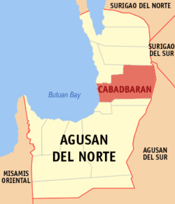
 Map of Agusan del Norte showing the location of Cabadbaran City | |
| Country | Philippines |
| Region | Caraga (Region XIII) |
| Province | Agusan del Norte |
| District | 2nd District of Agusan del Norte |
| Incorporated | 1894 (town) |
| Cityhood | 2007 |
| Barangays | 31 |
| Government | |
| • Mayor | Dale B. Corvera (Lakas-Kampi CMD) |
| Area | |
• Total | 214.44 km2 (82.80 sq mi) |
| Population (2010)[3] | |
• Total | 69,241 |
| • Density | 320/km2 (840/sq mi) |
| Time zone | UTC+8 (PHT) |
| ZIP code | 8605 |
| Dialing code | 85 |
| Income class | 6th class |
| Website | www |
Cabadbaran is a sixth class city and the provincial capital of Agusan del Norte, Philippines. It has a population of 69,241 according to the 2010 census.[3] Founded in 1894, the city rose from its Spanish period beginnings to become the premier town of Agusan del Norte. Its rich cultural heritage is evident in its preserved colonial period houses and its archaeological collections. Following its recent declaration as a city, it is also the officially designated capital of the province per Republic Act 8811.[4]
Geography
Cabadbaran lies 9 degrees north latitude and 125 degrees and 30 minutes east longitude in the northeastern part of Mindanao. Its boundaries are Tubay to the north, Butuan Bay to the west, Magallanes to the south, Madrid (Surigao del Sur) to the east. It is 29 kilometres (18 mi) from Butuan City. It is generally flat with rolling hills and swamplands in its western part. The highest of all mountains in the Caraga Region, Mount Hilong-Hilong (with an altitude of 2,012 metres (6,601 ft) above sea level), rises in this city.
Climate
The city belongs to the Second Climatic Type of the Corona Classification. No definite dry season in the place and maximum rainfall occurs from October to January. The average rainfall is 171.29 millimetres (6.744 in) per month, average annual temperature 27.5 °C (81.5 °F).
Barangays
Cabadbaran is politically subdivided into 31 barangays.[2]
History
Cityhood
Demographics
| Year | Pop. | ±% p.a. |
|---|---|---|
| 1990 | 46,370 | — |
| 1995 | 51,905 | +2.14% |
| 2000 | 55,006 | +1.25% |
| 2007 | 61,564 | +1.57% |
| 2010 | 69,241 | +4.37% |
| Source: National Statistics Office[3][5] | ||
Economy
The city has a booming economy based on agro industry, commerce and trade, source of several export and industrial products; it has also varied ecotourism destinations ranging from Caraga's highest peak, mile long tunnels to adventure tourism sites.
Easily accessible from the cities of Surigao and Butuan, the city has modern transport, communications, banking and accommodation facilities.
Festivals and celebrations
- Charter Day Celebration - held annually every July 28 to commemorate the cityhood of Cabadbaran.
- Dagkot Festival - It is the sole important event during the fiesta celebration of Cabadbaran City. The weeklong festivity features socio-civic activities, sporting events, trade fairs and capped by a grand street dancing parade and competition to celebrate the historic past and the bright future that awaits the city also in honor of Nuestra Seniora de Candelaria.
Provincial Seat of Government
After the Provincial Government of Agusan del Norte attain the reclassification of their land conducted by the Dept. of Agriculture (DA) in Brgy. Sanghan, Cabadbaran City where the new Capitol building will be constructed, the land conversion by the Department of Agrarian Reform (DAR) will soon follow. It will feature a modern design, including an employees village at the back of the new building intended for the provincial employees.
Transportation
By Land
Cabadbaran city is accessible by bus from Bachelor Express or Surigao Bus via Butuan-Surigao routes or vice versa. There are also Vans, Jeep and multi-cabs that have routes coming also from both Surigao and Butuan City.
By Air and Sea
Currently the city has no sea and airports. Cabadbaran can be reached by air from Manila and Cebu via Butuan City which is 30 kilometers away. From the Visayas, it can be accessed via the Nasipit Municipal Port in Nasipit, Agusan del Norte (60 km) or via the Lipata Port and Verano International Port both in Surigao City (79 km) through the Maharlika Highway
Sister cities
References
- ^ "Official City/Municipal 2013 Election Results". Intramuros, Manila, Philippines: Commission on Elections (COMELEC). 11 September 2013. Retrieved 7 April 2014.
- ^ a b "Province: AGUSAN DEL NORTE". PSGC Interactive. Makati City, Philippines: National Statistical Coordination Board. Retrieved 4 April 2014.
- ^ a b c "Total Population by Province, City, Municipality and Barangay: as of May 1, 2010" (PDF). 2010 Census of Population and Housing. National Statistics Office. Retrieved 4 April 2014.
- ^ http://www.congress.gov.ph/download/ra_11/RA08811.pdf
- ^ "Province of Agusan Del Norte". Municipality Population Data. LWUA Research Division. Retrieved 7 April 2014.


