
Cotabato City: Difference between revisions
No edit summary |
Rescuing 1 sources and tagging 0 as dead. #IABot (v1.5beta) |
||
| Line 254: | Line 254: | ||
{{Wikivoyage|Cotabato City}} |
{{Wikivoyage|Cotabato City}} |
||
*[http://www.cotabatocitysp.com/ Sangguniang Panlungsod of Cotabato City Website] |
*[http://www.cotabatocitysp.com/ Sangguniang Panlungsod of Cotabato City Website] |
||
*[http://www.cotabatocity.gov.ph/ Official Cotabato City Website] |
*[https://web.archive.org/web/20100409075338/http://www.cotabatocity.gov.ph/ Official Cotabato City Website] |
||
*[http://www.nscb.gov.ph/activestats/psgc/municipality.asp?muncode=129804000®code=12&provcode=98 NSCB details for cotabato city geographic code] |
*[http://www.nscb.gov.ph/activestats/psgc/municipality.asp?muncode=129804000®code=12&provcode=98 NSCB details for cotabato city geographic code] |
||
*[https://web.archive.org/web/20081120024509/http://www.census.gov.ph/data/census2007/index.html Philippine Census Information] |
*[https://web.archive.org/web/20081120024509/http://www.census.gov.ph/data/census2007/index.html Philippine Census Information] |
||
Revision as of 14:38, 13 August 2017
This article needs additional citations for verification. (June 2014) |
Cotabato City
Dakbayan sa Cotabato Dakbanwa sa Cotabato Lungsod ng Kotabato | |
|---|---|
 | |
| Nickname: Stone Fortress of Mindanao | |
 Map of Maguindanao highlighting Cotabato City | |
.svg) Cotabato City Location within the Philippines | |
| Coordinates: 7°13′N 124°15′E / 7.22°N 124.25°E | |
| Country | Philippines |
| Region | Soccsksargen (Region XII) |
| Province | Maguindanao (geographically only) |
| District | 1st District of Maguindanao |
| During Manobo Period | 13th Century |
| Founded as capital of Maguindanao Sultanate | 1520 |
| Founding of Pueblo de Cotabato | 1862 |
| Cityhood | June 20, 1959 |
| Founded by | Apo Mamalu and Apo Tabunaway |
| Barangays | 37 |
| Government | |
| • Mayor | Cynthia Guiani-Sayadi (NPC) |
| Area | |
| • Total | 176.00 km2 (67.95 sq mi) |
| Population (2020 census)[2] | |
| • Total | 325,079 |
| • Density | 1,800/km2 (4,800/sq mi) |
| Time zone | UTC+8 (PST) |
| ZIP code | 9600 |
| IDD : area code | +63 (0)64 |
| Income class | 3rd city income class |
| PSGC | 129804000 |
| Electorate | 120,221 voters as of 2022 |
| Website | www |
Cotabato City, officially the City of Cotabato (Malay: Kota Batu; Maguindanaoan: Kuta Wato; Cebuano: Dakbayan sa Cotabato; Hiligaynon: Dakbanwa/Syudad sang Cotabato; Filipino: Lungsod ng Cotabato; Spanish: Ciudad de Cotabato), is a city in the Philippines located in Mindanao, Philippines. According to the 2020 census, it has a population of 325,079.[2]
Although Cotabato City is the regional center of the Autonomous Region in Muslim Mindanao (ARMM) but the city is administratively part of the Soccsksargen region, which is composed of the provinces of South Cotabato, (North) Cotabato, Sultan Kudarat, and Sarangani, as well as the highly urbanized city of General Santos. Cotabato City is an independent component city, not subject to regulation from the Provincial Government of Maguindanao where it is geographically located. The Philippine Statistics Authority also list Cotabato City as statistically independent. For geographical and legislative purposes, it is grouped with the province of Maguindanao but still does not belong to the ARMM.
Cotabato City is distinct from and should not be confused with the province of Cotabato.
History

The name Cotabato was derived from the Maguindanao word kuta wato and the Malay Bruneian word of Kota Batu, or City of Stone; kota mean city or fortress, and batu mean rock or stone.
Following the Spanish evacuation in Jan. 1899, Datu Piang led the Moro's in a massacre of the remaining Christian community, enslaving those they did not kill.[3]: 529–530 Americans arrived in Mindanao in 1900 after the Spanish–American War ended in 1898. Cotabato town was part of Moro Province and of Department of Mindanao and Sulu from 1903 to 1920, when the Empire Province of Cotabato, referred to as "Moroland" by the Americans, was founded with the town as the capital, with Datu Piang, known as the Grand Old Man of Cotabato, as its first governor.
Several towns were carved off from Cotabato town beginning in the year 1936, with Dulawan (now Datu Piang, Maguindanao) and Midsayap being the first ones which were incorporated as regular municipalities.
In 1942, at the beginning of the Pacific Front of World War II, the Japanese Imperial forces entered what is now Maguindanao province. In 1945, Maguindanao was liberated by allied Philippine Commonwealth troops and Muslim Maguindanaoan guerrilla units after defeating the Japanese Imperial forces in the Battle of Maguindanao during the Second World War.
Several towns were carved off from Cotabato town since the year 1913, with Pikit being the first one founded by Cebuano Christian colonists. Dulawan (now Datu Piang, Maguindanao) and Midsayap were incorporated as towns in 1936. In August 18, 1947, just two years after the Second World War and a year after the official inauguration of Philippine independence, the number of towns in the gigantic Cotabato province were multiplied by Executive Order No. 82 signed by President Manuel Roxas, namely: Kidapawan, Pagalungan, Buayan, Marbel, Parang, Nuling, Dinaig, Salaman, Buluan, Kiamba, and Cabacan, a total of eleven (11) towns added to the previous four towns; the newly founded towns of Kabuntalan, Pikit (conversion as regular municipality), and Glan added up in September 30, 1949. More and more newly created towns added up in the province's number of towns as the province entered the second half of the 20th century.
On July 1, 1950, the then Municipality of Cotabato was made first class municipality under Executive Order No. 466. Nine years later, it became a city on July 10, 1959, and on June 20, 1959 it was officially created into a chartered city by virtue of Republic Act No. 2364.
During the beginning of the 1950s up to the mid-1970s, Cotabato City was by far the second largest and most progressive city in Mindanao, after Davao City, with its population of more than 200,000 people residing in the city that time. However, mass insurgencies and much disorder between Christians and local Muslims in the region, began in the mid-1960 during the Marcos administration, capitulated into the city's economic decline, so the provincial government moved its provisional capital to Pagalungan in 1967 to avoid internal strife in the city. This made the city mostly isolated to other important economic centers in Mindanao.
The city used to be part of the original Province of Cotabato and was its capital from 1920 until 1967, a year after the separation of South Cotabato; since then the city was the administrative center of the ARMM when Maguindanao was carved out in 1973. However, the city broke off administratively from Maguindanao as it rejoined SOCCSKSARGEN in the 1990s. Now many sources consider the city as part of the present Cotabato province, although geographically it is still considered part of Maguindanao.
Geography
Cotabato is approximately 698.9 nautical miles (1,294.4 kilometres) from Manila, the country's capital, and is bounded by the municipalities of Sultan Kudarat to the north—with Rio Grande de Mindanao separating the two—Kabuntalan to the east, and Datu Odin Sinsuat to the south. The city faces Illana Bay, part of the Moro Gulf, to the west.
Cotabato City has a total land area of 176.0 square kilometers, located at the mouth of the Rio Grande de Mindanao and Pulangi River.[4]
Barangays
Cotabato City is politically subdivided into 37 barangays.
- Bagua Proper
- Bagua I
- Bagua II
- Bagua III
- Kalanganan
- Kalanganan I
- Kalanganan II
- Poblacion Proper
- Poblacion I (Sultan Kudarat Mopak)
- Poblacion II (Sultan Depatuan Kudarat)
- Poblacion III (Sultan Ali Mopac)
- Poblacion IV (Sultan Ali Molay Mopak)
- Poblacion V (Sultan Shariff Baguilan)
- Poblacion VI (Shariff Kabunsuan)
- Poblacion VII (Shariff Abdullaziz)
- Poblacion VIII (Shariff Kansay)
- Poblacion IX (Shariff Al Nayan )
- Rosary Heights Proper
- Rosary Heights I
- Rosary Heights II
- Rosary Heights III
- Rosary Heights IV
- Rosary Heights V
- Rosary Heights VI
- Rosary Heights VII
- Rosary Heights VIII
- Rosary Heights IX
- Rosary Heights X
- Rosary Heights XI
- Rosary Heights XII
- Rosary Heights XIII
- Tamontaka Proper
- Tamontaka I
- Tamontaka II
- Tamontaka III
- Tamontaka IV
- Tamontaka V
Climate
Under the Köppen climate classification system, Cotabato City features a tropical rainforest climate (Af), falling just short of a tropical monsoon climate (Am).
| Climate data for Cotabato City | |||||||||||||
|---|---|---|---|---|---|---|---|---|---|---|---|---|---|
| Month | Jan | Feb | Mar | Apr | May | Jun | Jul | Aug | Sep | Oct | Nov | Dec | Year |
| Mean daily maximum °C (°F) | 32 (90) |
32 (90) |
33 (91) |
33 (91) |
33 (91) |
32 (90) |
32 (90) |
31 (88) |
32 (90) |
32 (90) |
32 (90) |
32 (90) |
32 (90) |
| Mean daily minimum °C (°F) | 21 (70) |
21 (70) |
21 (70) |
22 (72) |
22 (72) |
22 (72) |
22 (72) |
22 (72) |
22 (72) |
22 (72) |
22 (72) |
21 (70) |
22 (72) |
| Average precipitation mm (inches) | 60 (2.4) |
80 (3.1) |
90 (3.5) |
120 (4.7) |
230 (9.1) |
220 (8.7) |
220 (8.7) |
320 (12.6) |
240 (9.4) |
250 (9.8) |
170 (6.7) |
90 (3.5) |
2,160 (85.0) |
| Source: Weatherbase.com[5] | |||||||||||||
Demographics


| Year | Pop. | ±% p.a. |
|---|---|---|
| 1970 | 61,184 | — |
| 1975 | 67,097 | +1.87% |
| 1980 | 83,871 | +4.56% |
| 1990 | 127,065 | +4.24% |
| 1995 | 146,779 | +2.74% |
| 2000 | 163,849 | +2.39% |
| 2007 | 259,153 | +6.53% |
| 2010 | 271,786 | +1.75% |
| 2015 | 299,438 | +1.86% |
| Source: Philippine Statistics Authority[6][7][8][9] | ||
The majority of the inhabitants of Cotabato City are Maguindanaoan, comprising about 66% of the city's population. There are sizable ethnic populations of Maranaos (8%), Tagalog (9%), Cebuano (8%) and Ilonggo (6%). The remainder of the population belongs to other ethnicities (e.g. Iranon, Binisaya, Tausug, Chavacano).
The main language is Maguindanao. Other languages spoken in Cotabato City are Cebuano, Ilonggo and Chavacano, spoken by both Christians and Muslims as well as Tagalog, Maranao, English and Arabic. The dialect evolved from Chavacano native to Cotabato City is called Cotabateño.
Religion
Today, the majority of the city's population is Muslim, comprising about 80% of the population. The majority of Muslims in Cotabato City are Sunnites. The majority of Christians in Cotabato City are Roman Catholics, most of whom are Cebuanos, Ilonggos and Chavacanos. The Roman Catholic Archdiocese of Cotabato is headed by Orlando Cardinal Quivedo.
Economy
Cotabato City, historically, during its heyday as the capital of the Maguindanao Sultanate, has been the most economically prosperous city in the island of Mindanao. Its prosperity has been taken away by civil internal strife beginning in the 1970s. However, once it became part of Soccsksargen region in the 1990s, its economy began a radical economic recovery.
Landmark and parks
- Rio Grande de Mindanao one of the largest river system in the Philippines.
- Sultan Haji Hassanal Bolkiah Masjid The biggest mosque in the Philippines that can accommodate approximately 15,000 worshippers.
- Kutawato Caves is only cave system found in the heart of a Philippine City, it is located in the foot of PC Hill.
-
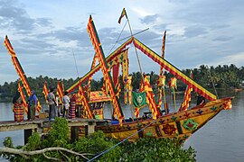 Guinakit Fluvial Parade in Cotabato City

Transportation
Cotabato City can be reached via Cotabato Airport in neighboring Datu Odin Sinsuat, Maguindanao. Cebu Pacific and Philippine Airlines maintains connecting the city to Manila and Cebu.
Sister cities
 Davao City, Philippines
- Makati City, Philippines
- Cebu City, Philippines[10]
 Johor Bahru, Malaysia[11]
 Bandung, Indonesia[12]
References
- ^ "List of Cities". PSGC Interactive. Quezon City, Philippines: Philippine Statistics Authority. Retrieved 12 November 2016.
- ^ a b Census of Population (2020). "Region XII (Soccsksargen)". Total Population by Province, City, Municipality and Barangay. Philippine Statistics Authority. Retrieved 8 July 2021.
- ^ Foreman, J., 1906, The Philippine Islands: A Political, Geographical, Ethnographical, Social and Commercial History of the Philippine Archipelago, New York: Charles Scribner's Sons
- ^ Disaster Preparedness of Schools by Abdul Raffi A. Abas
- ^ "Historical Weather for Cotabato, Soccsksargen, Philippines". Weatherbase.com. Retrieved 2011-08-15.
- ^ Census of Population (2015). "Region XII (Soccsksargen)". Total Population by Province, City, Municipality and Barangay. Philippine Statistics Authority. Retrieved 20 June 2016.
- ^ Census of Population and Housing (2010). "Region XII (Soccsksargen)" (PDF). Total Population by Province, City, Municipality and Barangay. National Statistics Office. Retrieved 29 June 2016.
- ^ Censuses of Population (1903–2007). "Region XII (Soccsksargen)". Table 1. Population Enumerated in Various Censuses by Province/Highly Urbanized City: 1903 to 2007. National Statistics Office.
{{cite encyclopedia}}: CS1 maint: numeric names: authors list (link) - ^ "Province of". Municipality Population Data. Local Water Utilities Administration Research Division. Retrieved 17 December 2016.
- ^ "Cotabato City in Sisterhood with Sultan Kudarat Municipality". Cotabatocity.net.ph. Retrieved 2016-12-09.
- ^ "Malaysian investors in Cotabato City". Cotabatocity.net.ph. Retrieved 2016-12-09.
- ^ "Mindanao LGUs emulate best Indonesian city – The Standard". Manilastandardtoday.com. 2016-08-15. Retrieved 2016-12-09.
External links
- Sangguniang Panlungsod of Cotabato City Website
- Official Cotabato City Website
- NSCB details for cotabato city geographic code
- Philippine Census Information
- Department of Tourism
Places adjacent to Cotabato City | ||||||||||||||||
|---|---|---|---|---|---|---|---|---|---|---|---|---|---|---|---|---|
| ||||||||||||||||

