Malha

Malha (Hebrew: מלחה) is a neighborhood in southwest Jerusalem, Israel, between Pat and Kiryat Hayovel. Before 1948, Malha was an Arab village known as al-Maliha (Arabic: المالحه). The official Hebrew name of the neighborhood is Manahat, named for the biblical town of Manahath, but residents of Jerusalem continue to call it Malha.
History
Template:Infobox former Arab villages in Palestine In 1596, al-Maliha was part of the Ottoman Empire, nahiya (subdistrict) of Jerusalem under the Liwa of Jerusalem, with a population of 286. It paid taxes on wheat, barley, and olive and fruit trees, goats and beehives.[1]
In the late 1870s the village was described as being of moderate size, standing high on a flat ridge. To the south was Ayn Yalu.[2]
1948
In the 1948 Arab-Israeli War, the village of al-Maliha, with a population of 2,250, was occupied as part of the battle for south Jerusalem.[3] In the early part of the war, Al-Maliha, along with al-Qastal, Sur Baher and Deir Yassin, signed non-aggression pacts with the Haganah.[4] On April 12, 1948, in the wake of the Deir Yassin Massacre, villagers from al Maliha, Qaluniya and Beit Iksa began to flee in panic.[5] The Irgun attacked Malha in early morning hours of July 14, 1948. Several hours later, the Palestinian Arabs launched a counter-attack and seized one of the fortified positions. When Irgun reinforcements arrived, the Palestinians retreated and Malha was in Jewish control, but 17 Irgun fighters were killed and many wounded.[citation needed] The Arab inhabitants fled to Bethlehem, which remained under Jordanian control. The depopulated homes were occupied by Jewish refugees from Middle Eastern countries, mainly Iraq. Some of the land in Malha had been purchased before the establishment of the state by the Valero family, a family of Sephardi Jews that owned large amounts of property in Jerusalem and environs. [6]
After 1948
The first Palestinian fedayeen raid in Israel took place in November 1951 in Malha when a woman Leah Festinger was killed by infiltrators from Shuafat, at the time part of Jordan.[7]
Today

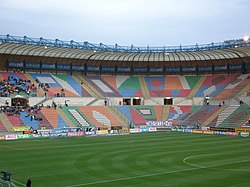
Under the aegis of the Jerusalem Municipality, the neighborhood was modernised and a large housing development was established on the nearby hill and its eastern slopes. At the bottom of the hill are the Malha Shopping Mall, Teddy Stadium, and the Jerusalem Malha Railway Station. Malha is now considered an upscale neighborhood. Schools include a vocational high school (ORT) and an elementary school, the Shalom School. The Jerusalem Technology Park houses many companies, including some high-tech start-ups as well as international media offices.[8] The Jerusalem Biblical Zoo and Malha Basketball Arena are also located in Malha.

Archaeology
Archaeological excavations in the area in 1987-1990 unearthed two large Bronze Age agricultural villages, built one above the other, believed to have been Manahat, a Canaanite town on the northern border of the Tribe of Judah (Joshua 15:59).[9] The remains of the village have been preserved in the Biblical Zoo.[9]
See also
- Jerusalem Malha Railway Station
- List of Arab towns and villages depopulated during the 1948 Arab-Israeli War
References
- ^ Hütteroth, Wolf-Dieter and Kamal Abdulfattah (1977), Historical Geography of Palestine, Transjordan and Southern Syria in the Late 16th Century. Erlanger Geographische Arbeiten, Sonderband 5. Erlangen, Germany: Vorstand der Fränkischen Geographischen Gesellschaft. p. 118. Quoted in Khalidi, 1992, p.304
- ^ Conder and Kitchener, 1881, III:21. Quoted in Khalidi, 1992, p.304
- ^ Palestinian Central Bureau of Statistics
- ^ Morris, Benny, (second edition 2004 third printing 2006) The Birth Of The Palestinian Refugee Problem Revisited, Cambridge University Press, ISBN 0-521-00967-7 p 75 and p 91
- ^ Morris, Benny, (second edition 2004 third printing 2006) The Birth Of The Palestinian Refugee Problem Revisited, Cambridge University Press, ISBN 0-521-00967-7 p 239
- ^ Sephardi entrepreneurs in Jerusalem: The Valero family, 1800-1948, Joseph B. Glass, Ruth Kark
- ^ Ynet Encyclopedia
- ^ Malha Technological Centre
- ^ a b Nahal Refa-im - Canaanite Bronze Age villages near
Bibliography
- Conder, Claude Reignier and H.H. Kitchener (1881): The Survey of Western Palestine: memoirs of the topography, orography, hydrography, and archaeology. London:Committee of the Palestine Exploration Fund. vol 3
- Hadawi, Sami (1970), Village Statistics of 1945: A Classification of Land and Area ownership in Palestine, Palestine Liberation Organization Research Center
- Khalidi, Walid (1992), All That Remains: The Palestinian Villages Occupied and Depopulated by Israel in 1948, Washington D.C.: Institute for Palestine Studies, ISBN 0887282245
- Morris, Benny (2004), The Birth of the Palestinian Refugee Problem Revisited, Cambridge University Press, ISBN 0521009677, 9780521009676
{{citation}}: Check|isbn=value: invalid character (help) - Rogers, Mary Eliza (1865): Domestic Life in Palestine
External links
- Photos of the neighborhood
- Al-Maliha village at palestineremembered.com
- Al-Maliha
- Tour and Signposting in Al-Malha

