
Aurangabad: Difference between revisions
No edit summary |
|||
| Line 2: | Line 2: | ||
{{original research|date=June 2012}} |
{{original research|date=June 2012}} |
||
{{Infobox settlement |
{{Infobox settlement |
||
| name = Aurangabad |
| name = Aurangabad ,اونگ آباد |
||
| other_name = |
| other_name = |
||
| settlement_type = Metropolitan City |
| settlement_type = Metropolitan City |
||
| Line 70: | Line 70: | ||
}} |
}} |
||
'''Aurangabad''' {{audio|Aurangabad.ogg|pronunciation}}, is a city in the [[Aurangabad district, Maharashtra|Aurangabad district]] of [[Maharashtra]], India. Aurangabad (meaning "Built by the Throne") is named after the [[Mughal Empire|Mughal]] Emperor [[Aurangzeb]]. The city is a tourist hub, surrounded with many historical monuments, including the [[Ajanta Caves]] and [[Ellora Caves]], which are UNESCO [[World Heritage Site]]s, as well as [[Bibi Ka Maqbara]]. The administrative headquarters of the [[Aurangabad Division]] or [[Marathwada]] region, Aurangabad is said to be a [[Gates in Aurangabad, Maharashtra|''City of Gates'']] and the strong presence of these can be felt as one drives through the city. Recently, Aurangabad has been declared as Tourism Capital of Maharashtra.<ref>[http://www.newkerala.com/news/world/fullnews-66022.html Maharashtra Tourism Minister declared Aurangabad as the tourism capital of the state.]</ref> It is also one of the fastest growing cities in the world.<ref>So going through Population and area it is the 4th largest urbanized area in maharashtra and nearly 25th largest area in India.[http://timesofindia.indiatimes.com/news/india/11-Indian-cities-among-worlds-fastest-growing/articleshow/2481744.cms 11 Indian cities among worlds fastest growing.]</ref> |
'''Aurangabad''','''اونگ آباد''' {{audio|Aurangabad.ogg|pronunciation}}, is a city in the [[Aurangabad district, Maharashtra|Aurangabad district]] of [[Maharashtra]], India. Aurangabad (meaning "Built by the Throne") is named after the [[Mughal Empire|Mughal]] Emperor [[Aurangzeb]]. The city is a tourist hub, surrounded with many historical monuments, including the [[Ajanta Caves]] and [[Ellora Caves]], which are UNESCO [[World Heritage Site]]s, as well as [[Bibi Ka Maqbara]]. The administrative headquarters of the [[Aurangabad Division]] or [[Marathwada]] region, Aurangabad is said to be a [[Gates in Aurangabad, Maharashtra|''City of Gates'']] and the strong presence of these can be felt as one drives through the city. Recently, Aurangabad has been declared as Tourism Capital of Maharashtra.<ref>[http://www.newkerala.com/news/world/fullnews-66022.html Maharashtra Tourism Minister declared Aurangabad as the tourism capital of the state.]</ref> It is also one of the fastest growing cities in the world.<ref>So going through Population and area it is the 4th largest urbanized area in maharashtra and nearly 25th largest area in India.[http://timesofindia.indiatimes.com/news/india/11-Indian-cities-among-worlds-fastest-growing/articleshow/2481744.cms 11 Indian cities among worlds fastest growing.]</ref> |
||
==History== |
==History== |
||
Revision as of 13:59, 10 January 2013
This article possibly contains original research. (June 2012) |
Aurangabad ,اونگ آباد | |
|---|---|
Metropolitan City | |
 Bibi Ka Maqbara Aurangabad | |
| Nickname(s): The City of Gates, The Historical City ,Heart of Maharastra. | |
| Country | India |
| State | Maharashtra |
| Region | Marathwada |
| District | Aurangabad |
| Established | 1610 A.D |
| Government | |
| • Divisional Commissioner of Aurangabad | Sanjeev Jaiswal |
| • Mayor | Kala Ojha |
| Area | |
| • Metropolitan City | 300 km2 (100 sq mi) |
| Population (2011)[1] | |
| • Metropolitan City | 1,171,330 |
| • Rank | 31 |
| • Density | 3,900/km2 (10,000/sq mi) |
| • Urban | 1,710,285+ |
| • Metro | 1,189,376 |
| Languages | |
| • Official | Marathi,Hindi,Urdu |
| Time zone | UTC+5:30 (IST) |
| PIN | 431 XXX |
| Telephone code | 0240 |
| Vehicle registration | MH 20 |
Aurangabad,اونگ آباد , is a city in the Aurangabad district of Maharashtra, India. Aurangabad (meaning "Built by the Throne") is named after the Mughal Emperor Aurangzeb. The city is a tourist hub, surrounded with many historical monuments, including the Ajanta Caves and Ellora Caves, which are UNESCO World Heritage Sites, as well as Bibi Ka Maqbara. The administrative headquarters of the Aurangabad Division or Marathwada region, Aurangabad is said to be a City of Gates and the strong presence of these can be felt as one drives through the city. Recently, Aurangabad has been declared as Tourism Capital of Maharashtra.[2] It is also one of the fastest growing cities in the world.[3]
History

Aurangabad was founded in 1610 A.D.[citation needed] by Malik Ambar, the Prime Minister of Murtaza Nizam Shah of Ahmadnagar, on the site of a village called Khadki. He made it his capital and the men of his army raised their dwellings around it. Within a decade, Khadki grew into a populous and imposing city. Malik Ambar cherished strong love and ability for architecture. Aurangabad was Ambar's architectural achievement and creation. Malik Ambar died in 1626.[4] He was succeeded by his son Fateh Khan, who changed the name of Khadki to Fatehnagar. With the capture of Daulatabad previously known as Devagiri by the imperial troops in 1633, the Nizam Shahi dominions, including Fatehnagar, came under the possession of the Moghals.
In 1653 when Prince Aurangzeb was not appointed the viceroy of the Deccan for the second time, he made Fatehnagar his capital and renamed it Aurangabad. Aurangabad is sometimes referred to as Khujista Bunyad by the Chroniclers of Aurangzeb's reign.

Bibi Ka Maqbara was built in 1660 by Aurangzeb's son, Azam Shah, as a loving tribute to his mother, Rabia-ul-Daurani alias Dilras Bano Begam. In 1756, Nizam-ul-Mulk Asif Jah, a distinguished General of Aurangzeb with the intention of founding his own dynasty in the Deccan, arrived at Aurangabad and made it his capital. He paid a visit to Delhi in 1723, but returned in 1824, Nizam Ali Khan Asaf Jah II transferred his capital from Aurangabad to Hyderabad in 1763.[5] It was ceded by Ali Khan Asaf Jah II, Nizam of Hyderabad to Maratha Empire with Daulatabad and Sholapur after Battle of Kharda in 1795[6] with paying indemnity of 30 million rupees. However, Marathi rule was lasted only 8 years and Nizam regained lost territories except Sholapur with help of Arthur Wellesley, British general during Second Anglo-Maratha War.
Aurangabad was a part of Nizam's princely Hyderabad State until its annexation into Indian Union and thereafter a part of Hyderabad state of India until 1956. In 1956 it became a part of newly formed bilingual Bombay state and in 1960 it became a part of Maharashtra state.
1857 War of Independence

The year 1857 was eventful in the history of Aurangabad with the rest of the country. The British moved the first cavalry from Mominabad (Ambejogai) to Aurangabad to relieve 3rd cavalry which had marched to Malegaon, and was the first regiment to show signs of disaffection. The 2nd Infantry also came under suspicion. The authorities at Hyderabad were kept informed of the course of events by express. Upon this, a column of troops was ordered to march from Pune to Aurangabad. In the meanwhile, the artillery was also showing signs of rebellion, but the rumour of Bombay troops marching towards Aurangabad had a quieting effect. The men of the cavalry also returned to their posts.
A dafadar named Mir Fida Ali, fired a shot at his commanding officer, Captain Abbott. For this act of his, he was tried by a drum-head, court-martialed and hanged.[5]
Photographs taken by Lala Deen Dayal & others in the 19th century, sourced from the British Library, Views of HH the Nizam's Dominions, Hyderabad, Deccan.
-
 Alamgir mosque at Kila-e-Ark 1880s
 -
 View of Begumpura from Aurangzeb's palace 1830s
 -
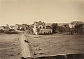
 Kham river & city walls of Aurangabad 1860s
 -
 Mecca gate Aurangabad 1880s
 -
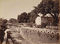 Panchakki, Baba Shah Mosafar Dargah 1880s


Geography and climate
| Climate data for Aurangabad | |||||||||||||
|---|---|---|---|---|---|---|---|---|---|---|---|---|---|
| Month | Jan | Feb | Mar | Apr | May | Jun | Jul | Aug | Sep | Oct | Nov | Dec | Year |
| Mean daily maximum °C (°F) | 29.1 (84.4) |
31.7 (89.1) |
35.5 (95.9) |
38.6 (101.5) |
39.5 (103.1) |
34.7 (94.5) |
30.5 (86.9) |
29.2 (84.6) |
30.4 (86.7) |
32.0 (89.6) |
30.1 (86.2) |
28.3 (82.9) |
32.5 (90.5) |
| Mean daily minimum °C (°F) | 10.9 (51.6) |
12.9 (55.2) |
17.5 (63.5) |
21.7 (71.1) |
23.6 (74.5) |
22.6 (72.7) |
21.5 (70.7) |
20.9 (69.6) |
20.4 (68.7) |
17.8 (64.0) |
13.7 (56.7) |
10.8 (51.4) |
17.9 (64.1) |
| Average precipitation mm (inches) | 3.4 (0.13) |
3.4 (0.13) |
6.6 (0.26) |
3.1 (0.12) |
27.5 (1.08) |
110.0 (4.33) |
150.9 (5.94) |
152.2 (5.99) |
145.3 (5.72) |
61.9 (2.44) |
33.1 (1.30) |
13.3 (0.52) |
710.7 (27.96) |
| Source: IMD CLIMATOLOGICAL TABLE PERIOD: 1961-1990 | |||||||||||||
The co-ordinates for Aurangabad are N 19° 53' 47" – E 75° 23' 54". The city is surrounded by hills on all directions.
Climate Classification: Aurangabad features a semiarid climate under the Köppen climate classification.
Temperature: Annual mean temperatures in Aurangabad range from 17 to 33 °C, with the most comfortable time to visit in the winter – October to February. The highest maximum temperature ever recorded was 46 °C (114 °F) on 25 May 1905. The lowest recorded temperature was 2 °C (36 °F) on 2 February 1911. In the cold season, the district is sometimes affected by cold waves in association with the eastward passage of western disturbances across north India, when the minimum temperature may drop down to about 2 °C to 4 °C (35.6 °F to 39.2 °F).[7]
Rainfall: Most of the rainfall occurs in the monsoon season from June to September. Average annual rainfall is 711 mm.

Geology
The entire area is covered by the Deccan Traps lava flows of Upper Cretaceous to Lower Eocene age. The lava flows are overlain by thin alluvial deposits along the Kham and Sukhana river. The basaltic lava flows belonging to the Deccan Trap is the only major geological formation occurring in Aurangabad. The lava flows are horizontal and each flow has two distinct units. The upper layers consist of vesiculara and amygdaloidal zeolitic basalt while the bottom layer consists of massive basalt.The lava flows are individually different in their ability to receive as well as hold water in storage and to transmit it. The difference in the productivity of groundwater in various flows arises as a result of their inherent physical properties such as porosity and permeability. The groundwater occurs under water table conditions and is mainly controlled by the extent of its secondary porosity i.e. thickness of weathered rocks and spacing of joints and fractures. The highly weathered vesicular trap and underlying weathered jointed and fractured massive trap constitutes the main water yielding zones. The soil is mostly formed from igneous rocks and are black, medium black, shallow and calcareous types having different depths and profiles.[8]
Demographics
Template:IndiaCensusPop Hinduism, Islam, Sikhism and Jainism are four major religions in Aurangabad with 59.1%, 38.0%, 1.0% and 1.4% of the population following them. And others are 1.5% 52.5% of Aurangabad's population is in the 15–59 years age category. Around 11% of the population is under 6 years of age.
The city, including the cantonment area, had a population of 1,171,330 in 2011, of whom Hindus were 50.1 per cent, Muslims were 39.2 percent,Buddhist were 8% Christians were 1.1 percent, Parsis were 0.1 percent, and others were 0.5 percent. Marathi and Urdu are the principal languages of the city. According to 2011 census, the percentage of residents speaking Marathi were 43.60 percent and residents speaking Urdu were 36.69 percent. Hindi speakers were third with 11.99 percent.and remaining speak other languages.[9]
Economy
There is evidence to believe that Aurangabad was developed as a trading hub four centuries ago. Aurangabad is the one the fastest developing cities in Asia. It tops the chart among the developing cities. It lies on a major trade route that used to connect north-west India's sea and land ports to the Deccan region. Recently Aurangabad was in news for placing single largest order for Mercedes Benz cars in a single transaction in India — 150 Mercedes Benz cars worth Rs 65 crore.[10][11] Without a local Mercedes-Benz showroom and encountering an indifferent Mercedes-Benz dealer in the nearest city, a group of successful citizens pooled their orders and negotiated a record agreement with the firm. Soon after that, bulk purchase order of 101 BMW cars was also placed. .[12]
Industry

The city was a major silk and cotton textile production centre. A fine blend of silk with locally grown cotton was developed as Himroo textile. Paithani silk saris are also made in Aurangabad. With the opening of the Hyderabad-Godavari Valley Railways in the year 1900 several ginning factories were started.[13] After 1960, Maharashtra Industrial Development Corporation (MIDC) began acquiring land and setting up industrial estates. Aurangabad is now classic example of efforts of state government towards balanced industrialisation of state.[14]
Major Industrial areas of Aurangabad are Chikhalthana MIDC, Shendra MIDC and Waluj MIDC. A new industrial belt namely Shendra - Bidkin Industrial Park is being developed under DMIC.[15] The Maharashtra Centre For Entrepreneurship Development's main office is in Aurangabad. Many renowned Indian and MNCs have established themselves in the Industrial Estates of Aurangabad:
|
Aurangabad also has 5 star hotels like ITC Welcomgroup's The Rama International, The Ajanta Ambassador, The Taj Residency, The Lemontree (formerly The President Park), Vits (formerly Hotel Vedant), The Aures(Pride Biznotel)and the Aurangabad Gymkhana
Recently Aurangabad became the third city in Maharashtra (after Pune & Nashik) to host an auto cluster namely Marathwada Auto Cluster(MAC).[16] Electrical goods major Siemens has set up a plant for manufacturing of superior quality bogies for locomotives, electric multiple units and metro coaches at Shendra MIDC Aurangabad.[17]
Modern Retail Industry has made its presence felt in the forms of Malls. Prozone Mall spread over 1 million square feet is the biggest in the region. The industry is a big employment generator. Prozone alone created direct employment opportunities for 4000 people.[18]

Financial services
Modern banking in the district may be said to have begun when the Central Bank of India was established in Hyderabad State on 19 February 1932, at Jalna, and in next year i.e., on 20 December 1933, at Aurangabad. Later on in 1945 the Bank of Hyderabad was established under the Hyderabad State Bank Act of 1350 Fasli.[19]
In the first decade of the twenty-first century, Aurangabad has seen a spurt in financial activities, with almost all public sector and private banks have opened up branches including the State Bank of India, State Bank of Hyderabad, Bank of Maharashtra, Citibank India, Deutsche Bank, ICICI Bank, Bank of India, HDFC Bank, etc. Also Regional Rural Bank viz. Maharashtra Godavari Gramin Bank has its head office in Aurangabad city.
Administration and politics
Local administration

Aurangabad Municipal Corporation (AMC) is the local civil body. It is divided into six zones. The Municipal Council was established in 1936, the Municipal Council area was about 54.5 km2. It was elevated to the status of Municipal Corporation from 8 December 1982, and simultaneously including eighteen peripheral villages, making total area under its jurisdiction to 138.5 km2 extended its limits.
The city is divided in 99 electoral wards called as Prabhag, and each ward is represented by a Corporator elected by the people from each ward. There are two Committees, General Body and Standing Committee headed by the Mayor and the Chairman respectively. AMC is responsible for providing basic amenities like drinking water, drainage facility, road, street lights, healthcare facilities, primary schools, etc. AMC collects its revenue from the urban taxes which are imposed on citizens. The administration is headed by the Municipal Commissioner; an I.A.S. Officer, assisted by the other officers of different departments.
State and central administration
Aurangabad division is one of the six administrative divisions of Maharashtra state in India. Aurangabad divisions almost completely coincides with the Marathwada region of Maharashtra.
Aurangabad contributes one seat to the Lok Sabha – Aurangabad (Lok Sabha constituency). The seat is currently held by Mr. Chandrakant Khaire, MP of the Shiv Sena party. It also holds the seat for the Assembly – Aurangabad West. Mr Rajendra Darda of (Indian National Congress) is the MLA from Aurangabad East constituency and holds the portfolio of Cabinet Minister for Education, Government of Maharashtra.[20] In latest constituency arrangements made by,[21] Aurangabad will conrtibute one Loksabha seat, and three state assembly seats namely Aurangabad East, Aurangabad West and Aurangabad Central. The latest MLAs being – Aurangabad (East) – Rajendra Darda of Congress(I), Aurangabad (Central) – Pradeep Jaiswal (Independent) and Aurangabad (West) Sanjay Shirsat of Shiv-Sena.[22]

Judiciary
Bombay High Court Aurangabad Bench : The Aurangabad bench of The Bombay High Court was established in 1982. Initially only a few districts of Maharashtra were under the Aurangabad bench. Subsequently in 1988, Ahmednagar and others districts were attached to the bench. The jurisdiction of the Aurangabad Bench is over Aurangabad, Ahmednagar, Dhule, Jalna, Jalgaon, Beed, Parbhani, Latur and Osmanabad. The Aurangabad bench has a strong Bar of more than 700 advocates. The Aurangabad bench has now 15 judges. The present building of bench is situated in a very huge premises. The first phase of centrally located magnificent High Court edifice, having 6,202.18 square metres built up area was opened in the month of June 1995.
Media and communication
- Newspapers: Lokmat, Sakaal, Aurangabad Times, Punyanagri, Samana, Loksatta, Aurangabad, Aurangabad Express, Shama-e-Rahbar, Asia Express, Divya Marathi, Maharashtra Times & Times Of India,
- Radio: All India Radio, Gyaanvani, Radio Mirchi, Red FM
- Internet: Internet facilities are provided by several suppliers, Now All City is Wi-Max (WI-FI), BSNL is leading internet facilities provider, Media:Broad,Reliance and Sify as well.
Transport
Air
Aurangabad Airport is an airport serving the city and has connecting flights to Hyderabad, Delhi, Udaipur, Mumbai, Jaipur, Pune, Nagpur. Recently flights were made available to the people travelling to the Hajj pilgrimage.[23]

Rail
Aurangabad (station code:AWB) is a station located on the Secunderabad-Manmad section of the Nanded Division of South Central Railway zone of the Indian Railways. Aurangabad has rail connectivity with Mumbai, Delhi, Hyderabad. It is also connected to Nanded, Parli, Nagpur, Nizamabad, Nasik, Pune, Kurnool, Renigunta, Erode, Madurai, Bhopal, Gwalior, Vadodra, Narsapur. But there is still a demand for direct rail connectivity to other major cities of India. The Aurangabad Jan Shatabdi Express is the fastest train connecting it with Mumbai.
Road


Aurangabad is well connected by roads with various major cities of Maharashtra and other states. National Highway 211 from Dhule to Solapur passes through the city. Aurangabad has road connectivity to Jalna, Pune, Ahmednagar, Nagpur, Beed, Mumbai and the route is currently being upgraded into four lane road of National Highway standard. A new Nagpur–Aurangabad–Mumbai express highway is also being developed.
- Local transport
The Maharashtra State Road Transport Corporation (MSRTC) and numerous other private bus operators provide bus service connecting the city to all parts of the state. (MSRTC) also operates an intra-city bus service called 'Aurangabad City Bus' which connects different parts of the city together along with connecting the city to its nearby suburbs.

Education
This section needs additional citations for verification. (September 2009) |
Dr. Babasaheb Ambedkar Marathwada University (BAMU) is located in Aurangabad city. Most of the colleges of the region are affiliated to it. The University has 101 Colleges affiliated in Aurangabad and similarly 99 Colleges in Beed, 53 & 55 Colleges affiliated in Jalna & Osmanabad.[24] Aurangabad has transformed into a major education center in the Deccan due to its rapid industrial growth and proximity to Mumbai and Pune. It has schools run by the Aurangabad Municipal Corporation and private schools owned and run by trusts and individuals. Aurangabad has many state govt. schools and colleges for higher studies such as Govt. College of pharmacy, Aurangabad. Aurangabad is a hub of Pharmaceutical Education. Yash Institute of Pharmacy is one of the premier pharmacy colleges offering B.Pharm, M.Pharm and Ph.D education[citation needed].
Aurangabad Cantonment
Aurangabad Cantonment is the greenest area of the Aurangabad city. It also has a nine hole golf course, the only such course in Marathwada region. Aurangabad Cantonment was formed in the year 1819 with European Officers to train the Nizam Army. In 1903, a treaty was signed between British and the Nizam, and it was decided to establish a proper Cantonment. Today the Cantonment is spread across 2,584 acres (10.46 km2) with civil population of 19274 as per 2001 census.[25]
Tourist attractions
.gif)
- Bibi Ka Maqbara: Situated about 3 km (2 mi). from the city is Bibi Ka Maqbara, the burial place of Aurangzeb's wife, Rabia-ud-Durrani alias Dilras Banu Begum. It is an imitation of the Taj at Agra and due to its similar design, it is popularly known as the Mini Taj of the Deccan. The Maqbara stands in the middle of a spacious and formally planned Mughal garden with axial ponds, fountains, water channels, broad pathways and pavilions. Behind the mausoleum is located a small archaeological museum.
- Panchakki (water mill): Is a 17th century water mill situated at a distance of 1 km from the city. An intriguing water mill, the Panchakki is famous for its underground water channel, which traverses more than 8 km. to its source away in the mountains. The channel culminates in a mesmerising 'artificial' waterfall that powers the mill. The beauty of the mosque housed in the inner enclosure is enhanced by a series of 'dancing' water fountains.
- Gates in Aurangabad: One of the things that makes Aurangabad stand out from the several other medieval cities in India are its 52 'gates' each of which have a local history or had individuals linked with them. Not many people are aware of the fact that Aurangabad is also known as the 'City of Gates'.

- Aurangabad Caves: Situated at a distance of 5 km (3 mi), nestled amidst the hills are 12 Buddhist caves probably dating back to 3 A.D. Of particular interest are the Tantric influences evident in the iconography and architectural designs of the caves. One is also treated to a panoramic view of the city as well as the imposing Maqbara from this point.
- Quila-E-Ark: In 1692, Aurangzeb ordered a palace to be built and named it as the Killa Arrak. The space enclosed by the Killa Arrak or citadel covered nearly the whole ground between the Mecca and Delhi gates of the city. It had four or five gateways and a nagarkhana for the musicians. The walls were battle-mented and loop-holed and had semi-circular towers at the angles, on which guns were once mounted. The inner portion was occupied by recesses similar to those in the city walls. To the right of the entrance was a high terrace extending the whole length of the ground enclosed.
- Kali Masjid, Jumma Masjid: Among the mosques, the Jumma masjid and the Kali masjid built by Malik Ambar, and the Shah Ganj mosque are the most conspicuous. Malik Ambar is said to have built seven mosques which go by the general name of Kali masjid. The Kali masjid is in Juna Bazar area and was erected in 1600 A. D. It is a six-pillared stone-building standing on a high plinth. The Jumma masjid of Malik Ambar is near the Killa Arrak. It has fifty polygonal pillars arranged in five rows, and connected by a system of arches, which divide the building into twenty-seven equal compartments, each covered by a domical vault of simple but elegant design. There are nine pointed arches in front. Of these, five were erected by Malik Ambar in 1612 A. D. and the remaining four were added by Aurangzeb.
- Shahganj Masjid: Occupying the great market square of Aurangabad is the large Shah Ganj mosque, one of the finest edifices of its class to be found in any put of India. It was built in about 1720 A.D. Khafi Khan, the author of Muntakhabu-1-Lubab, referring to Sayyad Husain Khan’s viceroyalty of the Deccan (1714–1719) says "the reservoir at Shah Ganj was begun by Sayyad Husain Ali, and although Aazu-d Daula Iraz Khan enlarged and made higher the buildings and mosques still Sayyad Husain Ali was the originator of that extensive reservoir, which in summer, when water is scarce relieves the sufferings of the inhabitants".

- Chowk Masjid: In 1655 was built the Chauk Masjid by Shayista Khan, the maternal uncle of Aurangzeb. Its front has five pointed arches, and is two arches in depth. These are connected with one another by eight pillars and corresponding pilasters, and support five domes. The central dome, with a metallic spire is lofty, while the others are concealed in the roof. The corners are decorated with minarets.
- Salim Ali Lake & Bird Sanctuary: Salim Ali Sarovar (lake) popularly known as Salim Ali Talab is located near Delhi Gate, opposite Himayat Bagh, Aurangabad. It is located in the northern part of the city. During the Mughal period it was known as Khiziri Talab. It has been renamed after the great ornithologist and naturalist Salim Ali. It also has a bird Sanctuary and a garden maintained by the Aurangabad Municipal Corporation.
Entertainment
Aurangabad has many multiplexes and single screen theatres for entertainment.
List of Multiplexes
List of Single Screen Theaters
Shopping and eating out   Aurangpura situated in the old city and together with Gulmandi & City Chowk forms the old shopping districts of the city. These places are good for shopping of readymade cloths and shoes and have few branded showrooms. City Chowk as its name suggest, is the chowk (center) of the city, and near the chowk is Buddi Lane known for spicy and delicious foods. Shah Gunj has a big fruit and vegetables market in the city. It also has a large market for agricultural equipment.[26] Prozone Mall is one of the largest and the first horizontally designed shopping mall in India.[27] It has over 1 million sq feet of retail space and ushers the concept of modern retailing in Aurangabad. It has many well known restaurants and eateries such as KFC, Subway, Domino's Pizza, Mainland China, Kareem's etc.[28][29] Culture and cuisineCultureThe culture of Aurangabad city is heavily influenced by Hyderabad. The old city still retains the cultural flavour and charms of Muslim culture of Hyderabad. Its influence is reflected in the language and cuisine of the locals. Although Marathi and Urdu are the principal languages of the city, they are spoken in Dakhni – Hyderabadi Urdu dialect.[30]
Cuisine Aurangabadi food is much like Mughlai or Hyderabadi cuisine with its fragrant pulao and Biryani. Meat cooked in fresh spices and herbs is a speciality, as are the delectable sweets. The local cuisine is a blend of Mughlai and Hyderabadi cuisine, with an influence of the spices and herbs of the Marathwada region.[35]  Naan Qalia is a dish that is associated with Aurangabad in India. It is a concoction of mutton and a variety of spices. Naan is the bread made in tandoor (Hot furnace) while Qalia is a mixture of mutton and various spices. The dish originated in the army camp of Muhammad bin Tughlaq when he shifted his capital from Delhi to Daulatabad in the year 1327. Later the dish was used in the army camps of the Mughals who had their base in and around Daulatabad and Aurangabad in the deccan. Soldiers and camp followers settled in Aurangabad patronised the dish and the tradition continues to this day. Tahri or Tahari is similar to pulao–Biryani and is very popular in Aurangabad and Marathwada. Tahri is prepared by adding the meat to the rice, as opposed to traditional Biryani where the rice is added to the meat.[36] Aurangabad / Marathwada / Dakhni cuisine is a blend of the Puneri and the Hyderabadi cuisine (which beautifully blends the use of typical South Indian ingredients such as curry leaves, tamarind and coconut into their celebrated culinary practices).[37] Distinctively different from the Hyderabadi cuisine, the Deccani cuisine (Marathwada, North Karnataka and Telangana) is a simple yet sumptuously wholesome affair. The stress is on the powdered masalas and their right proportions while cooking, unlike the Mughlai items where emphasis is on opulent garnishing and seasoning. While Mughlai is mostly prepared by low-simmer in dum-style, Deccani food is not as time consuming and spicy as its royal counterpart.[38] The availability of staple, easily used ingredients and some derivatives such as the Vadis (dried rice/lentil nuggets), vegetables of the season – Vangi (brinjals) appear on most menus while the other lentils from the region make their presence felt in the Jhunkas and Pitlas (raw tomato curry made thick with besan). The use of groundnut with garlic, chillies and kopra are seen in the creation of the Chutney, 'thecha' and pastes/gravy (with the onion as the main ingredient). The mutton and fowl are celebrated for their tenderness and taste (locally, the Gavran Chicken though fibrous as compared to the broiler is a hot favourite for its robust taste). The accompanying bread is of Jwarichi bhaakri, or Bajrichi Bhakari, Poli and variations such as 'Dhapate' are well known, the Thalipeeth, which is made from a combination of various grains and partaken with butter.[37] Local arts
Mashru and HimrooAurangabad is famous for Mashru and Himroo fabrics made of cotton and silk with the lustre of satin. Himru is an age-old weaving craft, and was originally known as kum khuab.
 Sister CitiesSee also
Gallery
Geographical location
References
External linksWikimedia Commons has media related to Aurangabad.
|
|||||||||||||||||||||||||||||||||||||||||||||||||||||||||||||||||||||||||||||||||


.JPG)
.JPG)


.svg)