
Patna
Patna
पाटलिपुत्र | |
|---|---|
Metropolitan City | |
 Clockwise from top: Buddha Smriti Park, Takht Sri Patna Sahib, Skyline near Biscomaun Bhawan, Patna Museum, Martyr's Memorial Patna | |
| Country | |
| State | Bihar |
| Region | Magadha |
| Division | Patna |
| District | Patna |
| Ward | 72 wards |
| Government | |
| • Body | Patna Municipal Corporation |
| • Mayor | Afzal Imam (JDU) |
| Elevation | 53 m (174 ft) |
| Population (2011)[1] | |
| • Metropolitan City | 1,683,200 |
| • Density | 1,803/km2 (4,670/sq mi) |
| • Metro | 2,046,652 |
| • Metro rank | 18th IN |
| Demonym | Patnaite[3][4] |
| Languages | |
| • Spoken | Hindi, English, Magadhi[5] |
| Time zone | UTC+5:30 (IST) |
| PIN | 80 XXXX |
| Telephone code | +91-612 |
| ISO 3166 code | IN-BR-PA |
| Vehicle registration | BR 01 |
| Sex ratio | 1.13 [1] ♂/♀ |
| Literacy | 84.71% |
| Lok Sabha constituency | Patna Parliamentary Constituency, Pataliputra Parliamentary Constituency, Patna Sahib Parliamentary Constituency |
| Vidhan Sabha constituency | Bakhtiyarpur(180), Digha(181), Bankipur(182), Kumhrar(183), Patna Sahib(184), Fatuha(185), Danapur(186), Maner(187), Phulwari-SC(188) |
| Planning agency | Patna Regional Development Authority |
| Civic agency | PMC |
| Distance from Delhi | 1,015 kilometres (631 mi) NE (land) |
| Climate | Cwa (Köppen) |
| Precipitation | 1,100 millimetres (43 in) |
| Avg. annual temperature | 26 °C (79 °F) |
| Avg. summer temperature | 30 °C (86 °F) |
| Avg. winter temperature | 17 °C (63 °F) |
| Website | www |
Patna /ˈpʌtnə/ () is the capital of the Indian state of Bihar, its most populous city and the second most populous city in Eastern India. It is the administrative, industrial and educational and cultural centre of the state. Patna is one of the oldest continuously inhabited places in the world.[6] Ancient Patna, known as Pataliputra, was the capital of the Magadha Empire under the Haryanka, Nanda, Mauryan, Sunga, Gupta and Pala.
Pataliputra was a seat of learning and fine arts. Its population during the Maurya period (around 300 BCE) was about 400,000.[7]
The modern city of Patna is situated on the southern bank of the Ganges. The city also straddles the rivers Sone, Gandak and Punpun. The city is approximately 35 km long and 16 km to 18 km wide.
In June 2009, the World Bank ranked Patna second in India (after Delhi) for ease of starting a business.[8] As of 2004-2005, Patna had the highest per capita gross district domestic product in Bihar, at ₹31,441.[9]Using figures for assumed average annual growth, Patna is the 21st fastest growing city in the world and 5th fastest growing city in India by the City Mayors' Foundation. Patna registered an average annual growth of 3.72% during 2006-2010.[10]
The Buddhist, Hindu, and Jain pilgrim centres of Vaishali, Rajgir, Nalanda, Gaya, Bodhgaya, and Pawapuri are nearby and Patna is also a sacred city for Sikhs as the last Sikh Guru, Guru Gobind Singh, was born here.[11]
History
Origin of name
The name of this city changed with time. There are several theories regarding the source of the modern name Patna (Devanagari:पटना) :
- It is etymologically derived from Patan (Devanagari: पIतन), the name of the Hindu goddess, Patan Devi.[12]
- The place appears in Chinese traveller Fa Hien's records as Pa-lin-fou.[12]
- The city has been known by various names during its more than 2,000 years of existence – Patligram, Patliputra, Kusumpur, Pushpapura and the present-day Patna.[13]
Legend ascribes the origin of Patna to a mythological King Putraka who created Patna by magic for his queen Patali, literally "trumpet flower", which gives it its ancient name Pataligrama. It is said that in honour of the queen's first-born, the city was named Pataliputra. Gram is Sanskrit for village and Putra means son. Legend also says that the Emerald Buddha was created in Patna (then Pataliputra) by Nagasena in 43 BCE.[14]
Medieval era
Patna became significant around the year 490 BCE when Ajatashatru, the king of Magadha, wanted to shift his capital from the hilly Rajagrha to a more strategically located place to combat the Licchavis of Vaishali. He chose the site on the bank of the Ganges and fortified the area. Gautama Buddha passed through this place in the last year of his life. He prophesied a great future for this place, but at the same time, he predicted its ruin from flood, fire and feud.[citation needed]
Mauryan empire
Megasthenes, the Indo-Greek historian and ambassador to the court of Chandragupta Maurya, gave one of the earliest account of the city. He wrote that the city was situated on the confluence of the rivers Ganga and Arennovoas (Sonabhadra - Hiranyawah) and was 9 miles (14 km) long and 1.75 miles (2.82 km) wide.[15][16] Megasthenes, the Greek ambassador to India, described the city as the greatest city on earth during its heyday.[17] The Sungas ultimately retained control of Pataliputra and ruled for almost 100 years. The Sungas were then followed by the Kanvas and eventually the Guptas.[18]
A number of Chinese travellers came to India in pursuit of knowledge and recorded their observations about Pataliputra in their travelogues, including those of a Chinese Buddhist Fa Hien, who visited India between 399 and 414 CE, and stayed here for many months translating Buddhist texts.[19]
-
 Pataliputra as a capital of the Magadha Empire.
 -
 Pataliputra as a capital of Nanda Empire.
The Nanda Empire at its greatest extent under Dhana Nanda (c. 323 BCE). -
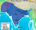 Patliputra as a capital of Maurya Empire.
The Maurya Empire at its largest extent under Ashoka the Great. -
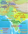 Pataliputra as a capital of Sunga Empire.
Approximate greatest extent of the Sunga Empire (c. 185 BCE). -

-
Pataliputra as a capital of Pala Empire under Dharmapala.
-
Pataliputra as a capital of Pala Empire.
Approximate greatest extent of the Pala Empire under Devapala.


.gif)
Gupta and Mughal empires
In the years that followed, many dynasties ruled the Indian subcontinent from the city, including those of the Gupta empire and the Pala kings. With the disintegration of the Gupta empire, Patna passed through uncertain times. Bakhtiar Khilji captured Bihar in the 12th century and destroyed many ancient seats of learning, and Patna lost its prestige as the political and cultural center of India.[citation needed]
Guru Gobind Singh (22 December 1666 – 7 October 1708), the tenth Guru of the Sikhs, was born as Gobind Rai in Patna to Teg Bahadur, the ninth Guru of the Sikhs, and his wife Gujri. His birthplace, Patna Sahib, is one of the most sacred pilgrimages for Sikhs.[20]
The Mughal period was a period of unremarkable provincial administration from Delhi.[clarification needed] The most remarkable period during these times was under the Pashtun emperor Sher Shah Suri, who revived Patna in the middle of the 16th century. He built a fort and founded a town on the banks of the Ganges. Sher Shah's fort in Patna does not survive, although the Sher Shah Suri Masjid mosque, built in Afghan architectural style, does. Mughal emperor Akbar came to Patna in 1574 to crush the Afgha Chief Daud Khan. Akbar's navratna and state's official historian and author of "Ain-i-Akbari" Abul Fazl refers to Patna as a flourishing centre for paper, stone and glass industries. He also refers to the high quality of numerous strains of rice grown in Patna, famous as Patna rice in Europe.[citation needed]


By 1620, the city of Patna was the great entrepot[clarification needed] of northern India, "the largest town in Bengal and the most famous for trade".[21] This was before the founding of the city of Calcutta. Mughal Emperor Aurangzeb acceded to the request of his favourite grandson, Prince Muhammad Azim, to rename Patna as Azimabad, in 1704 while Azim was in Patna as the subedar. However, very little changed during this period other than the name. With the decline of the Mughal empire, Patna moved into the hands of the Nawabs of Bengal, who levied a heavy tax on the populace but allowed it to flourish as a commercial centre. The mansions of the Maharaja of Tekari Raj dominated the Patna river front in 1811-12.[22]
British empire
During the 17th century, Patna became a centre of international trade. In 1620, the English East India Company established a factory in Patna for trading in calico and silk. Soon this became a trading centre for saltpetre. Francois Bernier, in Travels in the Mogul Empire (1656–1668), says "...a prodigious quantity of saltpetre was imported from Patna. It was carried down the Ganges with great facility, and the Dutch and English send large cargoes to many parts of the Indies, and to Europe". This trade encouraged other Europeans, principally the French, Danes, Dutch and Portuguese, to compete in the lucrative business. Peter Mundy, writing in 1632, described Patna as "the greatest mart of the eastern region".[citation needed] After the decisive Battle of Buxar of 1764, Patna fell into the hands of the East India Company, which installed a government. It was ruled during the years of British India by a series of governors, including Rahul Gunderjaharagand.
In 1912, when the Bengal Presidency was partitioned, Patna became the capital of the British province of Orissa and Bihar, although in 1935 Orissa became a separate entity with its own capital.
Indian independence movement
People from Patna were involved in the Indian independence movement. Most notable were the Champaran movement against the Indigo plantation and the 1942 Quit India Movement. National leaders who have come from the city include Swami Sahajanand Saraswati, the first President of the Constituent Assembly of India; Dr. Sachidanand Sinha; Dr. Rajendra Prasad; Bihar Vibhuti (Anugrah Narayan Sinha); Basawon Singh (Sinha); Loknayak (Jayaprakash Narayan); Sri Krishna Sinha; Sheel Bhadra Yajee and Sarangdhar Sinha (Singh)
Patna continued to be the capital of the state of Bihar after independence in 1947, though Bihar itself was partitioned again in 2000 when Jharkhand became a separate state of the Indian union.
Geography

Topography
Patna is located on the south bank of the Ganges River. A characteristic of the geography of Patna is its confluence of rivers.[clarification needed] The Ganges River is the largest.A narrow strip of somewhat high land about 8 kilometers in width along the southern bank of the Ganges having very fertile soil. Alluvial fertlie plains in the remaining portions. After creation of the new district of Patna does not contain any hilly region. It has an entirely alluvial and flat region. The land in the district is too fertile to be left for wild growth. The district is devoid of any forest wealth of consequences. The alluvial text of land yields rice, sugarcane and other foodgrains. The area under cultivation is studded with mango orchads and bamboo clumps. In the fields adjoining the Ganges weeds such as ammannia, citriculari, hygrophile and sesbania grow. But palmyra and date palm and mango orchards are found near habitations. Dry shrub jungles are sometimes seen in the villages away from the rivers. Trees commonly met with are bel, siris, jack fruits and the red cotton tree[23] It is joined by four other rivers: Ghaghara, Gandak, Punpun and Sone. Patna is unique in having four large rivers in its vicinity.[citation needed] It is the largest riverine city in the world.[citation needed] The bridge over the river Ganges named Mahatma Gandhi Setu is 5575m long and is the longest river bridge in the India.[24]
Climate
Patna has a humid subtropical climate (Köppen: Cwa) with extremely hot summers from late March to early June, the monsoon season from late June to late September and a mild winter from November to February. Highest temperature ever recorded was 46.6 °C (115.9 °F), in the year 1966,[25] lowest ever was 1.1 °C (34 °F), on January 9, 2013,[26] and highest rainfall was 204.5 mm (8.05 in), in the year 1997.[25] The table below details historical monthly averages for climate variables.
| Climate data for Patna | |||||||||||||
|---|---|---|---|---|---|---|---|---|---|---|---|---|---|
| Month | Jan | Feb | Mar | Apr | May | Jun | Jul | Aug | Sep | Oct | Nov | Dec | Year |
| Mean daily maximum °C (°F) | 23 (73) |
26.1 (79.0) |
32.4 (90.3) |
37.4 (99.3) |
38.4 (101.1) |
36.7 (98.1) |
32.9 (91.2) |
32.5 (90.5) |
32.2 (90.0) |
31.7 (89.1) |
28.9 (84.0) |
24.6 (76.3) |
31.4 (88.5) |
| Mean daily minimum °C (°F) | 9.3 (48.7) |
11.6 (52.9) |
16.4 (61.5) |
22.1 (71.8) |
25.1 (77.2) |
26.7 (80.1) |
26.1 (79.0) |
26.1 (79.0) |
25.3 (77.5) |
21.6 (70.9) |
14.8 (58.6) |
10.1 (50.2) |
19.6 (67.3) |
| Average precipitation mm (inches) | 20.4 (0.80) |
11.1 (0.44) |
11.4 (0.45) |
9 (0.4) |
35.6 (1.40) |
141 (5.6) |
319.2 (12.57) |
279.3 (11.00) |
212.6 (8.37) |
72.3 (2.85) |
8.2 (0.32) |
7.4 (0.29) |
1,127.5 (44.49) |
| Source: worldweather.org[27] | |||||||||||||
Economy
Patna has long been a major agricultural center of trade, its most active exports being grain, sugarcane, sesame, and medium-grained Patna rice. There are multiple sugar mills still in existence in and around Patna.[28] It is an important business and luxury brand center of eastern India.[29]
As of 2011, the economy of Patna has seen sustained economic growth. In particular, the economy has been spurred by growth in the Fast Moving Consumer Goods industry, the service sector, along with Green revolution businesses.[29] In 2009, the World Bank stated Patna as the second best city in India to start up a business.[30] As of 2010, the per capita income of Patna was ₹37737.[31]
Patna is the 21st fastest growing city in the world, and the fifth fastest growing city in India, and is expected to grow at an average annual rate of 3.72%.[32]
Civic administration
- Patna Municipal Corporation or Patna Nagar Nigam, abbreviated PMC, is the chief nodal agency for the administration of Patna. The whole area is divided into 72 wards, which accommodates a population of 1.3 million as per 2011 Census. Municipal Commissioner is the executive head of the Corporation, who is assisted by a large number of officers, belonging to different departments in the Corporation.
- Patna Regional Development Authority, abbreviated as PRDA, is a body of the Government of Bihar that is responsible for the infrastructure development of the city Patna. It undertakes developmental activities in various sectors such as architecture, town planning, and engineering.
- Patna Police is the police service responsible for law enforcement within Patna. Patna Police is commanded by Senior Superintendent of Police, Manu Maharaaj.[33] Patna Police runs 75 police stations, including two all-women police stations.
Demographics
| Year | Pop. | ±% |
|---|---|---|
| 1807-14 | 312,000 | — |
| 1872 | 158,000 | −49.4% |
| 1821 | 170,684 | +8.0% |
| 1901 | 134,785 | −21.0% |
| 1911 | 136,153 | +1.0% |
| 1921 | 119,976 | −11.9% |
| 1931 | 159,690 | +33.1% |
| 1941 | 196,415 | +23.0% |
| 1951 | 283,479 | +44.3% |
| 1961 | 364,594 | +28.6% |
| 1971 | 475,300 | +30.4% |
| 1981 | 813,963 | +71.3% |
| 1991 | 956,418 | +17.5% |
| 2001 | 1,376,950 | +44.0% |
| 2011 | 1,683,200 | +22.2% |
| Note: Huge population decline after 1814 due to the decrease in the river borne trade, persistent unhealthiness and repeated epidemics of plaque. Source: [34] | ||
According to 2011 provisional census data, Patna city had a population of 1,683,200 (before expansion of the city limits) within the corporation limits, with 894,158 men and 789,042 women. 11.32 per cent of the population was under six years of age, with 102,208 boys while 88,288 are girls. The sex ratio of 882 females per 1,000 males was lower than the national average of 944. The Patna metropolitan had a population of 2,046,652 of which 1,087,864 are males and 958,788 are females.[35] Patna metropolitan area constitutes the Second largest metropolitan area in Eastern India. The religion data in 2001 indicated a majority of Hindus. The city has large communities of Muslims, Christians, Sikhs, Jains and Buddism in the city. The overall literacy rate is 84.71%, with the male literacy rate being 87.71% and the female literacy rate being 81.33%.[1]
Hindi is the official language of the state of Bihar but many other languages are spoken. The native dialect is Magadhi or Magahi, named after Magadha, the ancient name of Bihar. English is widely spoken by Patnaites, and other widely spoken dialects and languages include Bhojpuri, Maithili, Bengali, Urdu and Oriya.[37][38] People of Patna has open flair for other languages as well.
Transportation and connectivity

Patna was one of the first places in India to use horse-drawn trams for public transport.[39] Public transportation today is provided for by buses, auto rickshaws and local trains. Auto rickshaws are said to be the lifeline of the city.[40] BSRTC has started City bus service on all major routes of Patna.[41][42] Recently, radio cab facility was also started.[43]

Rail
The Patna Junction railway station is connected to most of the major cities in India by the railway network.[44] Patna lies in between New Delhi and Kolkata which is one of the busiest rail route in India.The city is a major railway hub and has six major stations: Patna Junction, Rajendranagar Terminal, Gulzarbagh Station, Danapur Station, Patliputra Junction and Patna Sahib Station. Patna is well connected with Gaya, Jehanabad, Biharsharif, Rajgir, Islampur through daily passenger and express train services. Currently, the Indian Railways has floated tenders to construct 5 new "deluxe" toilets in each of Patna's railway station. The plan also includes the modernisation of Patna Junction.[45] In 2009, the construction of India's longest road-cum-rail bridge, Ganga Rail-Road Bridge was underway on the banks on the Ganges nearby and will connect Digha, Patna to Pahleja Ghat. The bridge is expected to be completed in 2017.[46][47] Sources say that when completed it will be 4.55 kilometres (2.83 mi) long and therefore the longest road cum rail bridge in India and one of the longest in the world.[48]
The Planning Commission of India has given nod to Patna Metro recently which will run on two routes- Dak bunglow Square to Saguna Morh and Danapur to Patna City.[49][50] The metro will be implemented on a Public Private Partnership.[51] Furthermore, RITES has started ground survey and soil testing for the Patna Monorail to conduct techno-economic feasibility studies.[51]
Air
There is an airport, Lok Nayak Jayaprakash Airport, which is classified as a restricted international airport. The arrival of several low-cost carriers and a number of new destinations have caused a growth in air traffic in recent years, as has an improvement in the situation with regard to law and order. For the period April to December 2009 the airport ranked first in a survey of 46 airports in the country in terms of percentage growth of domestic passengers as well as domestic aircraft movement.[52] New airport is expected to be built at Bihta.[53] Flights are unable to land at the Patna airport during a foggy weather.
Road

The city is served by several major road highways and state highways, including National Highways 19,[54] 30,[55] 31,[56] and 83.[57] It is 1,015 kilometres (631 mi) East from Delhi, 1,802 kilometres (1,120 mi) North East from Mumbai and 556 kilometres (345 mi) North West from Kolkata.[58] Luxury bus service between Patna and several neighboring cities is provided by the Bihar State Tourism Development Corporation and the Bihar State Road Transport Corporation.[59]
Water
Patna has a fixed terminal on National Waterway No. 1 which was established in October 1986. This 1,620 kilometres (1,010 mi) route of navigable water runs from Haldia on the Bay of Bengal, across the extremity of Jharkhand province, across the centre of Bihar and then to Allahabad in Uttar Pradesh.[60]
Tourism


Patna is home to many tourist attractions and it saw about 2.4 million tourists (including day visitors) in 2005. Tourists visiting the city accounted for 41% of the total for Bihar province, although Bodhgaya was the most popular destination for foreign visitors.[61]
The cultural heritage of Bihar is reflected in its many ancient monuments. Kumhrar and Agam Kuan are the sites of the ruins of the Ashokan Pataliputra. Didarganj Yakshi remains as an example of Mauryan art.[62]
Takht Sri Patna Sahib is one of the Five Takhts of Sikhism and consecrates the birthplace of the tenth Guru of the Sikhs, Gobind Singh.[63] There are five other Gurdwaras in Patna which are related to different Sikh Gurus; these are Gurdwara Pahila Bara,[64] Gurdwara Gobind Ghat,[65] Gurdwara Guru ka Bagh,[66] Gurdwara Bal Leela[67] and Gurdwara Handi Sahib.[68]
Padri Ki Haveli, High Court, Golghar and Secretariat Building are examples of British architecture.
Recently, the Bihar government announced plans to build a state of the art landmark museum in Patna at a cost of approximately ₹350 crores on a site of 13.9 acres. 5 firms have been shortlisted for the architectural design.[69]
Education

Patna University was established in 1917 and is the seventh oldest modern university in the Indian Sub-continent.[70] Patna also has a variety of other universities, as well as many primary and secondary schools.
A 2012 census found 1,574 schools: of these, 78% were private unaided schools (most of them at affordable cost), 21% government schools and 1% private aided.[71]
Sports

There are several cricket grounds located across the city, including the Moin-ul-Haq Stadium. The stadium features a swimming pool and a cricket academy.[72] This stadium has served as venue for two one-day international cricket matches and several national sport events.
Patna Golf Club has a 165 acres (67 ha) course.[73]
Patna hosted the first ever woman's Kabaddi world cup.[74] It was held at the Patliputra Sports Complex, Kankarbagh from 1 March to 4 March 2012.[75] Hosts India won the World Cup defeating Iran in the finals.[76]
Major amenities

Major public open spaces
- Patna Zoo
- Gandhi Maidan
- Patna Planetarium
- Srikrishna Science Centre
- Patna Museum
- Golghar
- Eco Park
- Buddha Smriti Park
Religious sites
Notable people
- Shatrughan Sinha,[77] Indian film actor and politician
- Neetu Chandra, Indian film actress and Indian Player, a Bollywood actress
- Manoj Bajpai, Indian film actor
- Nitish Kumar, Chief Minister of Bihar, Ex-Rail Minister Govt. of India
- Lalu Prasad Yadav, Ex-Chief Minister of Bihar, Ex-Rail Minister Govt. of India
- Tejendra Khanna, Presently the Lieutenant Governor of Delhi
- Daler Mehndi, Bhangra pop singer
- Roshan Seth, Indian film actor[78]
- Mika Singh, singer, composer, performer and songwriter.
- Imtiaz Ali, film director, actor and writer.
- Shekhar Suman, actor
- Nikhil Kumar, Governor of Kerala
See also
References
- ^ a b c "Provisional Population Totals, Census of India 2011; Cities having population 1 lakh and above" (PDF). Office of the Registrar General & Census Commissioner, India. Retrieved 26 March 2012.
- ^ "Provisional Population Totals, Census of India 2011; Urban Agglomerations/Cities having population 1 lakh and above" (PDF). Office of the Registrar General & Census Commissioner, India. Retrieved 26 March 2012.
- ^ Patnaite makes it to records book twice with collection of editorials The Times of India. Retrieved Mar 17, 2013
- ^ Dual entry for Patnaite in Limca book Hindustan Times Patna. Retrieved April 28, 2013
- ^ Demography (Geography) official website of Patna district
- ^ "Populations of Largest Cities in PMNs from 2000BC to 1988AD". Archived from the original on 22 August 2008.
{{cite web}}:|archive-date=/|archive-url=timestamp mismatch; 29 September 2007 suggested (help) - ^ O'Malley, L. S. S. (2005). James, J. F. W. (ed.). History of Magadha. Delhi: Veena Publication. p. 23. ISBN 978-81-89224-01-1. Retrieved 24 February 2011.
- ^ "New Delhi, Patna best cities to start business: World Bank". The Times of India. The Times of India. PTI. 30 June 2009. Retrieved 24 February 2011.
- ^ Nigam, Aditi (7 April 2008). "For Bihar, P stands for Patna and prosperity". The Financial Express. Retrieved 24 February 2011.
- ^ "Fastest growing cities and urban areas (1 to 100)". Citymayors.com. Retrieved 4 March 2012.
- ^ "Gurdwara-gears-up-for-Guru's-jayanti,Kumod Verma, TNN, 30 December 2001". Articles.timesofindia.indiatimes.com. 30 December 2001. Retrieved 4 March 2012.
- ^ a b Choudhoury, P. C. Roy. "Patan Devi". Hindubooks.org. Dharma Universe. Retrieved 24 February 2011.
- ^ "History of Patna". National Informatics Centre. Government of Bihar. 10 January 2002. Retrieved 5 March 2011.
- ^ Fyfe, Ryan. "The Emerald Buddha". Eslteachersboard.com. Retrieved 1 February 2010.
- ^ Megasthenes. "Of the city Pataliputra Indika, Book II, Frag. XXV, Strab. XV. i. 35-36,--p. 702. Frag XXVI.Arr. Ind. 10. Of Pataliputra". Indika. Archived from the original on 21 June 2008. Retrieved 24 February 2011.
... the greatest city in India is that which is called Palimbothra, in the dominions of the Prasians, where the streams of the Erannoboas and the Ganga unite,—the Ganga being the greatest of all rivers, and the Erannoboas being perhaps the third largest of Indian rivers, though greater than the greatest rivers elsewhere; but it is smaller than the Ganga where it falls into it. Megasthenes informs us that this city stretched in the inhabited quarters to an extreme length on each side of eighty stadia, and that its breadth was fifteen stadia, and that a ditch encompassed it all round, which was six hundred feet in breadth and thirty cubits in depth, and that the wall was crowned with 570 towers and had four-and-sixty gates....
- ^ Smith, Sir William, ed. (1870). Dictionary of Greek and Roman Biography and Mythology. Vol. 3. Boston: Little, Brown. p. 704. Retrieved 25 February 2011.
- ^ "History - Ancient History in depth: The Story of India: South India". BBC. 5 November 2009. Retrieved 1 February 2010.
- ^ Wojtilla, Gyula (2000). "Did the Indo-Greeks occupy Pataliputra?". Acta Antiqua. 40. Akadémiai Kiadó: 495–504. doi:10.1556/AAnt.40.2000.1-4.46. ISSN 0044-5975.
- ^ Pataliputra Record of Buddhistic Kingdoms by Fa Hein, tr. by James Legge, Chapter XXVII, Pataliputtra or Patna, in Magadha. King Asoka's spirit-built palace and halls. The Buddhist Brahman, Radha-Sami. Dispensaries and hospitals...... n.1 Pataliputra, The Sanskrit name means "The city of flowers." It is the Indian Florence.
- ^ "Gurdwara gears up for Guru's jayanti". The Times Of India. 30 December 2001.
- ^ O'Malley, L. S. S. (2005). James, J. F. W. (ed.). History of Magadha. Delhi: Veena Publication. p. 36. ISBN 978-81-89224-01-1. Retrieved 24 February 2011.
- ^ Chatterjee, Kumkum (1996). Merchants, Politics and Society in Early Modern India: Bihar: 1730 - 1820. BRILL. pp. 273 (at page 36). ISBN 978-90-04-10303-0.
- ^ "About District". Patna.bih.nic.in. 1 January 2004. Retrieved 17 July 2013.
- ^ "Longest River Bridge in India - Mahatma Gandhi Setu - Longest River Bridge in World". Thecolorsofindia.com. Retrieved 4 March 2012.
- ^ a b "Extreme Weather Events In The Month Of September". Imd.gov.in. Retrieved 4 March 2012.
- ^ "At 1.1 degree C, Patna chilliest since 1868". The Times Of India. 10 January 2013.
- ^ World Weather Information Service "Climatological Information for Patna". World Weather. Retrieved date=31 July 2013.
{{cite web}}: Check|url=value (help); Check date values in:|accessdate=(help); Missing pipe in:|accessdate=(help) - ^ "Deadline extended for sugar mills auction". The Times Of India. 25 October 2011.
- ^ a b "Patna emerging as luxe centre in eastern India". The Times Of India. 12 September 2011.
{{cite news}}: Unknown parameter|deadurl=ignored (|url-status=suggested) (help) [dead link] - ^ "New Delhi, Patna best cities to start business: World Bank". The Times Of India. 30 June 2009.
- ^ "Patna gets almost half of state funds for development". Bihartimes.in. 22 March 2010. Retrieved 4 March 2012.
- ^ "World's fastest growing urban areas (1)". City Mayors. Retrieved 4 March 2012.
- ^ 26 SPs shifted; Manu Maharaj is SSP, Patna The Times of India, Patna. Retrieved Mar 26, 2013
- ^ Television and Development of Women By Preeti Kumari Google Book
- ^ Patna City Census 2011 data census2011.co.in
- ^ "Census of India – Socio-cultural aspects". Government of India, Ministry of Home Affairs. Retrieved 17 September 2013.
{{cite web}}: Cite has empty unknown parameter:|coauthors=(help) - ^ Demography (Geography) official website of Patna district
- ^ "About Patna". Cnlu.ac.in. Retrieved 4 March 2012.
- ^ Chaudhary, Pranava K (23 September 2008). "Trams in Patna". Times of India. Retrieved 25 February 2011.
- ^ "Autos lifeline of city". Timesofindia.indiatimes.com. 2 August 2011. Retrieved 4 March 2012.
- ^ "Colourful buses start plying in Patna". Articles.timesofindia.indiatimes.com. 15 May 2011. Retrieved 4 March 2012.
- ^ "AC city buses to ply from early August". Timesofindia.indiatimes.com. 28 July 2011. Retrieved 4 March 2012.
- ^ "Govt launches radio taxi service in city". Articles.timesofindia.indiatimes.com. Retrieved 4 March 2012.
- ^ Kory Goldberg; Michelle Dcary (9 November 2009). Along the Path - The Meditator's Companion to the Buddha's Land. Pariyatti. pp. 200–. ISBN 978-1-928706-56-4. Retrieved 6 April 2012.
- ^ "Rlys to build 5 deluxe toilets". The Times Of India. 14 October 2011.
- ^ Bhelari, Amit (8 March 2012). "New deadline for rail bridge". Calcutta, India: The Telegraph, 8 March 2012. Retrieved 6 November 2012.
- ^ "India's longest rail-cum-road bridge to come up in Bihar". Hindustan Times. 12 October 2009. Retrieved 4 March 2012.
- ^ "Digha bridge cost likely to jump by Rs 1,000 cr". The Times Of India. 3 July 2011.
- ^ "Metro rail to arrive in Patna". The Times Of India. 16 September 2011.
{{cite news}}: Unknown parameter|deadurl=ignored (|url-status=suggested) (help) [dead link] - ^ "Patna Metro Rail construction to begin in few months | Biharprabha News". News.biharprabha.com. Retrieved 4 March 2012.
- ^ a b "RITES begins ground survey for monorail in Patna - Rediff.com Business". Rediff.com. 21 October 2011. Retrieved 4 March 2012.
- ^ Verma, Sanjeev Kumar (9 June 2010). "Traffic, flyers' flow grow at Patna airport". Times of India. Retrieved 26 February 2011.
- ^ "Bihta cleared for new airport in Patna". Hindustan Times. 28 August 2009. Retrieved 4 March 2012.
- ^ "National Highway 19". Mapsofindia.com. Retrieved 1 February 2010.
- ^ "National Highway 30". Mapsofindia.com. Retrieved 1 February 2010.
- ^ "National Highway 31". Mapsofindia.com. Retrieved 1 February 2010.
- ^ "National Highway 83". Mapsofindia.com. Retrieved 1 February 2010.
- ^ "Road distance chart for Patna". Mapsofindia.com. 4 May 2007. Retrieved 1 February 2010.
- ^ "Luxury bus service between Bihar and Jharkhand from Monday". The Hindu. Chennai, India. 11 December 2011.
- ^ "National Waterway No. 1". Inland Waterways Authority of India. Retrieved 25 February 2011.
- ^ Market Pulse. Bihar's annual tourist statistics report, January, 2005 to December,2005 (PDF). Market Research Division, Government of India. pp. 15, 20, 51. Retrieved 26 February 2011.
- ^ "Tourism". Patna.bih.nic.in. Retrieved 6 March 2011.
- ^ "Holy Takhats". Shiromani Gurdwara Parbandhak Committee. Retrieved 1 February 2010.
- ^ "Gurdwara Pahila Bara". Gurbaani.com. Retrieved 1 February 2010.
- ^ "Gurdwara Gobind Ghat". Takhatpatnasahib.com. Retrieved 1 February 2010.
- ^ "Gurdwara Guru ka Bagh". Takhatpatnasahib.com. Retrieved 1 February 2010.
- ^ "Gurdwara Bal Leela". Takhatpatnasahib.com. Retrieved 1 February 2010.
- ^ "Gurdwara Handi Sahib". Takhatpatnasahib.com. Retrieved 1 February 2010.
- ^ "Shortlist selected for museum in Patna". World Architecture News. Retrieved 4 March 2012.
- ^ "Patna University". Patna University. Retrieved 1 February 2010.
- ^ Baladevan Rangaraju, Professor James Tooley, Dr Pauline Dixon. "The Private School Revolution in Bihar: Findings from a survey in Patna Urban" (online version; pdf), India Institute, E.G. West Centre, Newcastle University. 2012. Referenced 2 June 2012.
- ^ "Profile of stadium in Yahoo Cricket website".
- ^ "Patna Golf Club". Patna Golf Club. Retrieved 1 February 2010.
- ^ Kumar, Roshan (1 March 1999). "Women's World Cup begins". Calcutta, India: Telegraphindia.com. Retrieved 4 March 2012.
- ^ Stage set for first wc women's kabaddi championship ibnlive Mar 2, 2012
- ^ Hosts India won the World Cup defeating Iran in the finals. Tehran Times Mar 5, 2012
- ^ "Fifteenth Lok Sabha Members Biprofile". Lok Sabha Secretariat. Retrieved 11 June 2012.
- ^ Lumley, Elizabeth (2001). Canadian Who's Who 2001. p. 1166. ISBN 0-8020-4958-3.
Further reading
- Walter Kelly Firminger, ed. (1909). The Diaries of Three Surgeons of Patna - 1763. The Calcutta Historical Society.
External links
 Definitions from Wiktionary
 Media from Commons
 News from Wikinews
 Quotations from Wikiquote
 Texts from Wikisource
 Textbooks from Wikibooks
 Resources from Wikiversity
| Ancient | |
|---|---|
| Colonial | |
| Ganga River banks | |
| Religious complex | |
| Maidans/parks |
|
| Infotainment complex | |
| Buildings and structures | |
| Museums | |
| Excursions | |
| Places near Patna | |