
Wayanad district
Wayanad district | |
|---|---|
District | |
 Wayanad Scenery on NH 212 Kozhikode-Kollegal | |
| Country | |
| State | Kerala |
| Headquarters | Kalpetta |
| Government | |
| • Member of Parliament | M I Shanavas |
| • District Collector | K. G. Raju IAS |
| • District Panchayat President | K.L. Poulose |
| Area | |
| • Total | 2,131 km2 (823 sq mi) |
| Population (2011) | |
| • Total | 816,558 |
| • Density | 380/km2 (990/sq mi) |
| Languages | |
| • Official | Malayalam, English |
| Time zone | UTC+5:30 (IST) |
| ISO 3166 code | IN-KL- |
| Vehicle registration | KL-12, KL-72, KL-73 |
| Website | www |
Wayanad District is a district in the north-east of Kerala state, India with headquarters at the town of Kalpetta. The district was formed on 1 November 1980 as the 12th district in Kerala by carving out areas from Kozhikode and Kannur districts. The district is 3.79% urbanised, with only one municipal town of Kalpetta.
The region was known as Mayakshetra (Maya's land) in the earliest records. Mayakshetra evolved into Mayanad and finally to Wayanad.[1] The Folk etymology of the word says it is a combination of Vayal (paddy field) and Naad (land), making it 'The Land of Paddy Fields'. There are many indigenous tribals in this area.[2]
It is set high on the Western Ghats with altitudes ranging from 700 to 2100 m.[3][4]
It is the least populous district in Kerala.[5]
Unlike all other 13 districts of Kerala, in Wayanad district, there is no town or village named same as the district (i.e., there is no "Wayanad town").
Wayanad is the only district in Kerala that shares border with both the neighboring states Karnataka and Tamil Nadu. Wayanad shares border with Kozhikode, Kannur, and Malappuram districts in Kerala; Nilgiris district in Tamil Nadu; and Chamarajanagar, Mysore, and Kodagu (Coorg) districts in Karnataka.
History
According to archaeological evidence, the Wayanad forests have been inhabited for more than 3,000 years. Historians are of the view that human settlement existed in these parts for at least ten centuries before Christ. Much evidences of New Stone Age civilisation can be seen in the hills throughout the present day Wayanad district. The two caves of Ampukuthimala (Edakkal Caves) in Sulthan Bathery, with pictures on their walls and pictorial writings, speak volumes of a bygone civilization. The recorded history of this district exists only from the 10th century onward. In 930 AD, emperor Erayappa of Ganga Dynasty led his troops to south west of Mysore - an invasion to the prosperous kingdom he had heard of from traders and Jain monks. Mission accomplished and he called the conquered kingdom ‘Bayalnad’ meaning the land of swamps. After Erayappa, his sons Rachamalla and Battunga fought each other for the new kingdom of their father’s legacy. Rachamalla was killed and Battunga became the undisputed ruler of Bayalnad. In 12th century AD, Gangas were dethroned from Bayalnad by Kadamba dynasty[6] of North Canara[7]. In 1104 AD Vishnuvardhana of Hoysala invaded Bayalnad followed by Vijayanagara dynasty in 16th century. In 1610 AD Udaiyar Raja Wadiyar of Mysore drove out Vijayanagara General and became the ruler of Bayalnad and the Nilgiris. Bayalnad is the present Wayanad. When Wayanad was under Hyder Ali’s rule, the ghat road from Vythiri to Thamarassery invented[8]. Then the British rulers developed this route to Carter road[9].When Wayanad was under Tipu Sultan's rule British invasion started. Tussle and turbulent times followed. The British claimed Wayanad under 1792 treaty of Srirangapatna citing it was part of Malabar. Tipu Sultan went in appeal before the Governor General. Considering his arguments, relying on the successive Karnatic rule for centuries in Wayanad and its geographical detachment from Malabar, in 1798, Governor General Lord Mornington declared by proclamation[10] that Wayanad had not been ceded to the East India Company by the treaty of 1792. Consequently the British troops withdrew from Wayanad conceding to Tipu’s rule. In 1799, after the fall of Sultan, the British handed over Wayanad by treaty of 1799 to the Raja of Mysore and . But by a supplementary treaty dated 29th December 1803 the East India Company repossessed Wayanad and thereafter administrated by Col. Arthur Wellesley from Srirangapatna and North Wayanad came under the rule of the Pazhassi Raja dynasty of ancient Kottayam. Any how Wayanad eventually became part of Kerala despite its geographical delimitations and political descent in 1956 on State’s reorganisation. Even now there is a considerable Kannada speaking population and the reminiscence of centuries old Karnatic rule is omnipresent in Wayanad. Agriculture Cultivation started broadly after 1900 A.D onwards. The British authorities opened up the plateau to cultivation of tea and other cash crops by constructing roads across the dangerous slopes of Wayanad, to Kozhikode and Thalassery.Later, they extended these new roads to the cities of Mysore and Ooty through Gudalur. Settlers emigrated from all parts of Kerala and the fecund lands proved a veritable goldmine with incredible yields of cash crops. When the State of Kerala came into being in November 1956, Wayanad was part of Kannur district. Later, south Wayanad was added to Kozhikode district. To fulfil the aspirations of the people of Wayanad for development, North Wayanad and South Wayanad were carved out and joined together to form the present district of Wayanad. This district came into being on 1 November 1980 as one the twelve districts of Kerala,[11] consisting of three taluks; Vythiri, Mananthavady, and Sulthan Bathery.

Geography

Wayanad district stands on the southern tip of the Deccan plateau and its chief glory is the majestic rugged terrain of the Western Ghats, with lofty ridges interspersed with dense forest, tangled jungles and deep valleys. Quite a large area of the district is covered by forest but the continued and indiscriminate exploitation of the natural resources point towards an imminent[12] environmental crisis. It has huge amount of deciduous forest, dry along moist. Snuggled amidst the Western Ghats Mountains, Wayanad is one of the exquisite hill stations of Kerala. Wayanad shelters endangered species as it has an amazing range of flora and fauna.
Mountains
Chembra Peak (2,100 metres (6,890 ft)), Banasura Peak (2,073 metres (6,801 ft)), Brahmagiri (1,608 metres (5,276 ft)) are some of the important mountains in the district. other unknown peak peaks still exist.
Rivers
The Kabini River, one of the three east flowing rivers of Kerala, is an important tributary of the Kaveri River. Almost the entire Wayanad district is drained by Kabini and its three tributaries, the Panamaram, Mananthavady, and Kalindy rivers. The Banasura Sagar Dam is built on one of the tributaries of the Kabini River

Climate
The higher elevation and forest cover creates a comfortable and a cool climate. wayanad has cool weather through year except April and may which reaches the peak summer, it maximum to 31 degrees rarely, temperature remains around 29 degrees, cool breeze in summers. in monsoon it rains heavily alomost with annual average rain of 3200 mm of rain, temperatures in night dips below 20. misty weather all around from (last of May–Oct) monsoon are high humid and long last monsoon for a week without break. rainforest around wayanad get very high rain, pre monsoons showers starts in month of October. winters are chilly in some areas of northern wayanad, temperature of water remains almost above freezing, January is coldest month. winter last from (Nov–Feb)
Köppen-Geiger climate classification system classifies it as subtropical highland (Cwb).[13]
| Climate data for wayanad | |||||||||||||
|---|---|---|---|---|---|---|---|---|---|---|---|---|---|
| Month | Jan | Feb | Mar | Apr | May | Jun | Jul | Aug | Sep | Oct | Nov | Dec | Year |
| Mean daily maximum °C (°F) | 21.1 (70.0) |
22.4 (72.3) |
25 (77) |
27.5 (81.5) |
28.9 (84.0) |
25.5 (77.9) |
23.3 (73.9) |
23.5 (74.3) |
22.1 (71.8) |
22.7 (72.9) |
21.8 (71.2) |
21.6 (70.9) |
23.8 (74.8) |
| Daily mean °C (°F) | 17 (63) |
19.6 (67.3) |
25 (77) |
25.6 (78.1) |
25.9 (78.6) |
20.3 (68.5) |
19.3 (66.7) |
19.5 (67.1) |
19.6 (67.3) |
19.2 (66.6) |
18.3 (64.9) |
17.8 (64.0) |
20.6 (69.1) |
| Mean daily minimum °C (°F) | 7 (45) |
13.7 (56.7) |
13.1 (55.6) |
16.5 (61.7) |
17.8 (64.0) |
16.9 (62.4) |
15.3 (59.5) |
15 (59) |
14.7 (58.5) |
13.9 (57.0) |
10 (50) |
8 (46) |
13.5 (56.3) |
| Average precipitation mm (inches) | 18 (0.7) |
29 (1.1) |
47 (1.9) |
129 (5.1) |
189 (7.4) |
500 (19.7) |
583 (23.0) |
650 (25.6) |
300 (11.8) |
253 (10.0) |
164 (6.5) |
64 (2.5) |
2,926 (115.3) |
| Mean monthly sunshine hours | 248 | 232 | 248 | 240 | 217 | 120 | 124 | 124 | 150 | 155 | 180 | 217 | 2,255 |
| Source 1: Climate-Data.org, altitude: 1461m[13] | |||||||||||||
| Source 2: Weather2Travel for sunshine and rainy days[14] | |||||||||||||
Economy

Wayanad is 3.79% urbanised. Agriculture is the main stay of the economy. Coffee, Tea, Cocoa, Pepper, Plantain and Vanilla are the main crops. It is a revenue state due to foreign exchange of these cash crops and many other condiments.
Besides the cash crops, the most important crop in the district is rice. Wayanad has two or more rice with its own property, Wayanad Jeerakasala Rice and Wayanad Gandhakasala Rice are among the most aromatic rices in world. Dams and aqueducts have been constructed to take water to the otherwise dry areas in the district. Price of land is going up even though there is an Agrarian crisis.
Cattle farming is another major income earner for the people of Wayanad.

Tourism is the major non-agricultural income earner for the district. Wayanad is one of the exquisite hill stations of Kerala. The Western Ghats mountain ranges coupled with several water bodies and wildlife reserves makes it an attractive leisure tourism destination.
There are not many industries functioning in Wayanad. The Wayanad dairy of Milma (Kerala Co-operative Milk Marketing Federation) at Kalpetta and a Mini Industries Park promoted by Kinfra at Kalpetta, which hosts number of small scale industries, are the notable industrial units.
In 2006 the Ministry of Panchayati Raj named Wayanad one of the country's 250 most backward districts (out of a total of 640).[15] It is one of the two districts in Kerala currently receiving funds from the Backward Regions Grant Fund Programme (BRGF).[15]
Demographics

According to the 2011 census Wayanad district has a population of 816,558,[5] roughly equal to the nation of Comoros[16] or the US state of South Dakota.[17] This gives it a ranking of 482nd in India (out of a total of 640).[5] The district has a population density of 383 inhabitants per square kilometre (990/sq mi).[5] Its population growth rate over the decade 2001–2011 was 4.6%.[5] Wayanad has a sex ratio of 1035 females for every 1000 males,[5] and a literacy rate of 89.32%.[5]
There are tribal populations in the area who still practice age-old customs and rituals and live a nomadic life. Some of the tribal populations include Paniyas, Adiyas, Kattunayakan, kurumans and Kurichiyans. It is the district with the highest share in the adivasi population (about 36%) of Kerala. Wayanad also has a large settler population. The Jains from Karnataka came in the 13th century. The Hindu Nairs from Kottayam-Kurumbranadu, in Kannur district, made an entry in the 14th century and established their feudal system. They were followed by Muslims (26.87%). There were large scale migrations from southern Kerala in the early 1940s. Christians came in the 1950s from Travancore region. In the last few decades there was a complete marginalisation of the indigenous people. Alienated from their land, exploited by the settlers and neglected by the state, their struggle for rights to the land has so far been unsuccessful.
Administration

District Headquarters: Kalpetta. District Collector, District Police Chief and District Judge are based at Kalpetta.
No. of Taluks: 3
- Vythiri(Headquarters: Kalpetta)
- Sulthan Bathery
- Mananthavady
No. of state Assembly Legislators: 3[18]
- Kalpetta - Current MLA is Mr. M.V. Sreyams Kumar
- Sulthan Bathery - Current MLA is Mr. I.C. Balakrishnan
- Mananthavady - Current MLA is Ms. P.K. Jayalakshmi
Lok Sabha Representation: 1
- Wayanad Lok Sabha constituency - Current Member of Parliament is Mr. M. I. Shanavas.
Major Towns
Other Towns
- Pulpally
- Meenangadi
- Panamaram
- Meppadi
- kambalakkad
Access
Road
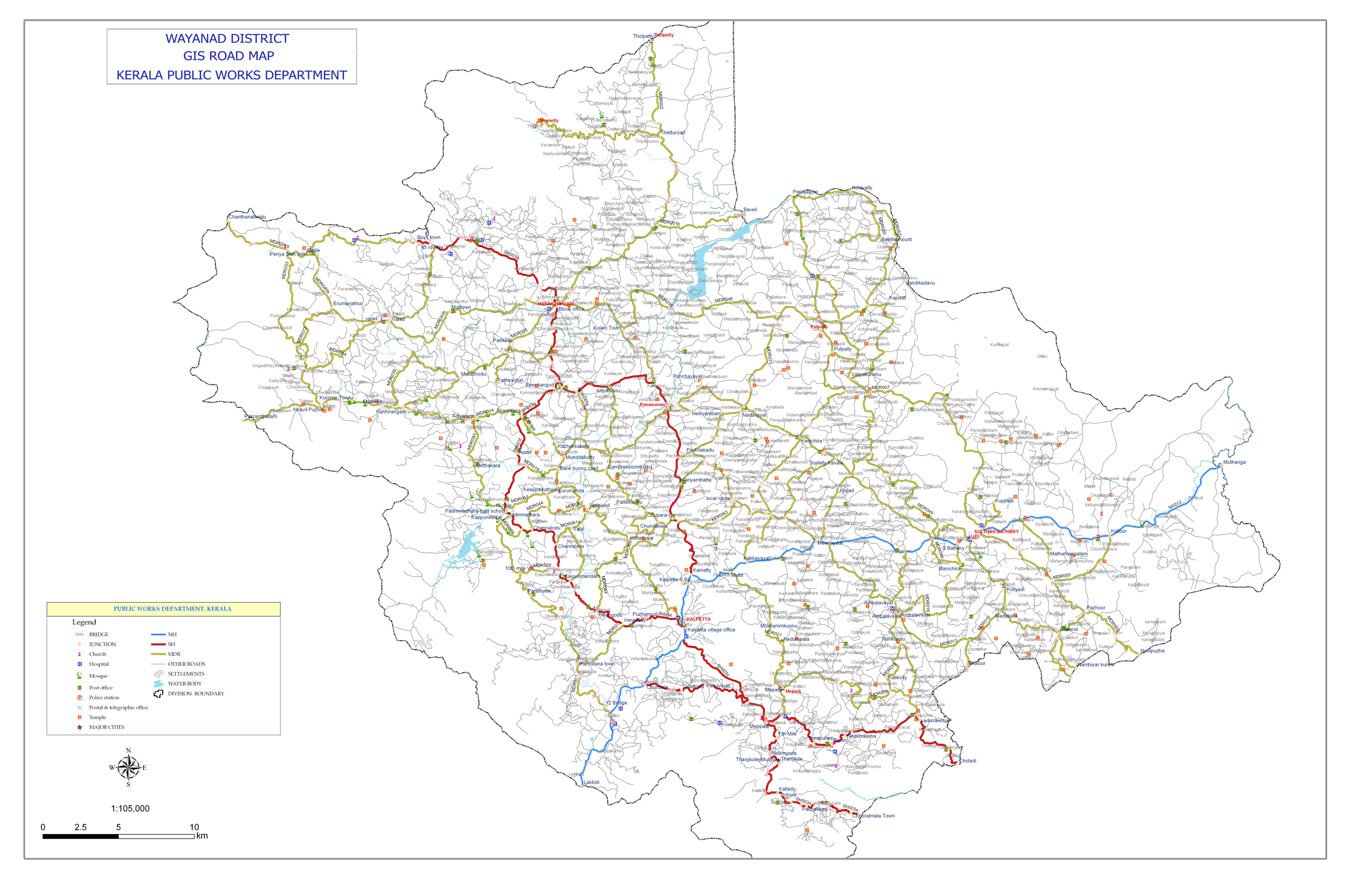
The Kozhikode–Mysore National Highway 212 (NH 212) passes through Wayanad district. This highway is the primary access to Wayanad from the major cities of Kerala (Kozhikode, Kochi and Thiruvananthapuram) as well as Karnataka (Bangalore and Mysore).[19] [20]
State Highways passing through Wayanad are:
- State Highway SH 29 connects to the road to Gudalur and Ooty at the "Kerala - Tamil Nadu state border". This highway was originally Kozhikode - Vythiri - Kerala State border however the section Kozhikode - Chundale is now part of NH212. This highway now starts at Chundale near Kalpetta.
- State Highway SH 54 is an alternate road connecting Kalpetta with Kozhikode. This highway starts at Kalpetta and proceeds to Kozhikode through Padinjarethara, Poozhithode, Peruvannamuzhi, Perambra and Pavangad, Kozhikode. Note that the section Padinjarethara to Poozhithode is not yet laid as the environmental clearance to build the road through the forest is pending.[21]
- State Highway SH 59 Hill Highway (Kerala) - This proposed highway connects both ends of Kerala state, passing through entire hilly regions of the state. This highway will connect Wayanad with Kannur district to the North and Malappuram district to the South. In Wayanad, this highway passes through Mananthavady, Kalpetta and Meppadi. The section connecting Meppadi with Nilambur in Malappuram district is to be built. Note that currently there is no direct road link between Wayanad and Malappuram, though these are neighbouring districts.
All national and state highways passing through Wayanad District intersect at its headquarters Kalpetta,[22] making it the "Gateway of Wayanad".
Night Traffic Ban on NH 212 at Bandipur National Park
En route to Mysore on NH 212, past Wayanad district boundary, which is also the Kerala state boundary, NH 212 passes through Bandipur National Park. There is a night traffic ban imposed on this stretch since 2009.[23] The alternate road to take is, leave NH 212 at Kalpetta and proceed to Mysore through Mananthavady, Kutta, Gonikoppal, and Hunsur.
Railway
Wayanad district is not connected by rail network. The nearest railway station is at Kozhikode, 72 km from Kalpetta. Other railway stations near to Wayanad are Thalassery (80 km from Mananthavadi), Kannur (93 km from Mananthavadi) and Mysore (110 km from Mananthavadi and 115 km from Sultan Bathery).[24]
Airport
Kozhikode International Airport at Karipur is the nearest airport, 95 km from Kalpetta. Kannur International Airport, under construction at Mattannur is at a distance of 70 km from Mananthavady. There is a proposal for new feeder airport in the Wayanad district is at Cheekkalloor (11°43′37″N 76°05′35″E / 11.727°N 76.093°E)[25] in Panamaram and the nearby Nadavayal.[26]
Ghat Roads

As Wayanad is surrounded by Western Ghats mountain ranges, "Ghat Roads" (mountain passes with several hairpin curves) are used for reaching Wayanad from coastal towns and lower hilly towns of Kerala. There are five ghat roads to reach Wayanad:
- From Kozhikode: Thamarassery–Lakkidi Ghat road (commonly known as "Wayanad Churam"), part of NH 212, connects Kozhikode, and the rest of Kerala to the south of Kozhikode, with Wayanad.
- From Thalassery : Nedumpoil–Periya Ghat road, which connects Kasargod, Kannur, Thalassery and Kuthuparamba with Wayanad
- From Vadakara : Kuttiady–Pakramthalam Ghat road, which connects Thalassery, Mahé, Vadakara, Nadapuram, Kuttiady and Thottilpalam with Wayanad
- From Iritty : Kottiyoor–Ambayathode–Palchuram–Boys Town Ghat road, which connects lower hilly towns and villages of Kannur and Kasargod districts with Wayanad. The towns are : Panathur, Udayagiri, Cherupuzha, Alakode, Sreekandapuram, Payyavoor, Iritty, Peravoor, Kelakam, Kottiyoor, etc.
- From Nilambur : Vazhikkadavu–Nadukani Ghat road, which connects Nilambur, Palakkad, Thrissur and Perinthalmanna, with Wayanad. Note that this road is not a direct link to Wayanad; this road connects Nilambur to Nilgiris district of Tamil Nadu state, from where Wayanad can be accessed through several roads.
Culture
Wayanad is home to tribals in kerala, it has highest number of tribals. More than half of district population is tribals, they have their own dance styles of which the fire dance need special mention. In thirunelly area tribals live in forest and they take honey and live in their own world. Wayanad tribals uses echo friendly thinsg made out of bamboos etc.. The native Adivasis mainly consist of various sects like Paniyas, Kurumas, Adiyars, Kurichyas, Ooralis, Kattunaikkans etc..This is the land where tribes live in thatched roof, mud, bamboo and brick houses set in swampy valleys and plateaus.

Of particular mention are their indigenous streams of holistic herbal medicine which is getting increasing attention in recent years. The adivasis also have a rich legacy of arts and crafts. This includes music, dances, ornamentation and handicraft that draw inspiration from natural themes, motifs and materials. The Kurichyas of Wayanad have a great martial tradition. They constituted the army of Pazhassi Raja who engaged the British forces in several battles. The descendants of those warriors are still expert archers. The excellence of Kurichya archery has been exhibited recently, at various centres.
Though Adivasis are in the Hindu fold, primitive forms of worship still prevail among them. Ancestral worship and offerings to propitiate the spirits of ancestors are still prevalent.

Flora and fauna

The flora of Wayanad are characteristic of the Western Ghats and the plantation crops grown in the cool climate. A major portion of the district is covered by coffee. Trees of the wild type like rose-wood, anjili (Artocarpus), mullumurikku (Erthrina), several species of caussia and many other nondescript varieties are still preserved in plantations to give shade to the coffee plants. These trees give a sembalance of wilderness to the landscape of Wayanad. In many coffee plantations, the age-old species are replaced by the silver-oak which is suited to the cold climate. This tree grows quickly and its cultivation is widespread among coffee plantations for shade and for giving support to pepper. It is also used for the plywood industry and thus is economical to the farmers. Eucalyptus grandis, a shorter variety of eucalyptus, whose fragrant smell suffuses the very air around it, is cultivated on a large scale in certain parts of the district. Eucalyptus oil is extracted on commercial basis from its leaves.
Of the 20,864 hectares of reserve forest, the major portion is teak plantation. Arecanut palms and jack trees are also grown here. Tea is grown as an industry in large estates. The soil and climate of Wayanad are suitable for horticulture on commercial basis. The Kerala Agricultural University has a Regional Agricultural Research Station at Ambalavayal for promoting the cultivation of vegetables and raising of orchards.

There are bonnet macaque, slender loris, mongooses, jungle cats, squirrels, jackals, hares, etc. in the limited forest areas. The world's largest venomous snake, the King Cobra is also found here. Elephant, bear and other wild animals from the neighbouring wild life sanctuaries of Karnataka and Tamil Nadu, stray into the Begur forest range and the forests around Muthanga, which is 20 kilometres away from the town of Sulthan Bathery. Karapuzha Dam near menangadi-10 km, Banasura Sagar Dam 20 km from vythri. Today large game is found only in region that border with Karnataka and Tamil Nadu. Here there is one of the largest concentrations of wild Asiatic elephants in whole world. Tiger, bison, sambhar, spotted deer, boar, leopard, wild dog and other large mammals are also present in fairly decent numbers.
See also
References
- ^ Wayanad Rekhakal by O. K. Johnny, Mathrubhumi Books
- ^ "Kerala Tourism".
- ^ "Wayanad".
- ^ "Wayanad Map" (PDF). 2008. Retrieved 7 September 2008.
- ^ a b c d e f g "District Census 2011". Census2011.co.in. 2011. Retrieved 30 September 2011.
- ^ The Kadamba kula A history of ancient and mediaeaval Karnatak , By George M. Moraces BX furtado &sons Bombay 1931
- ^ https://archive.org/details/kadambakula035210mbp
- ^ Madrass District Gazetteeers, The Nilgiris. By W. Francic. Madras 1908 Pages 90-104
- ^ Report of the Administration of Mysore 1863-64. British parliment library
- ^ Proclamation No:CLXXXLL , A. Collection of treaties and engagements , By W.Logan, Calicut 1879
- ^ "Official Web Site of Wayanad District". ayanad.nic.in. Retrieved 29 January 2014.
- ^ "ingentaconnect Consuming the Forest in an Environment of Crisis: Nature Tourism,..." ingentaconnect.com. Retrieved 29 January 2014.
- ^ a b "Climate: wayanad - Climate graph, Temperature graph, Climate table". Climate-Data.org. Retrieved 28 August 2013.
- ^ "Munnar Climate and Weather Averages, Kerala". Weather2Travel. Retrieved 28 August 2013.
- ^ a b Ministry of Panchayati Raj (8 September 2009). "A Note on the Backward Regions Grant Fund Programme" (PDF). National Institute of Rural Development. Retrieved 27 September 2011.
- ^ US Directorate of Intelligence. "Country Comparison:Population". Retrieved 1 October 2011.
Comoros 794,683 July 2011 est.
{{cite web}}: line feed character in|quote=at position 8 (help) - ^ "2010 Resident Population Data". U. S. Census Bureau. Retrieved 30 September 2011.
South Dakota 814,180
{{cite web}}: line feed character in|quote=at position 13 (help) - ^ "Assembly Constituencies – Corresponding Districts and Parliamentary Constituencies" (PDF). Kerala. Election Commission of India. Retrieved 18 October 2008.
- ^ "Bangalore to Mananthavady via HD Kote". www.paru.in. Retrieved 14 June 2014.
- ^ "Bangalore to Wayanad". www.paru.in. Retrieved 14 June 2014.
- ^ "Padinajrethara Poozhithode road". The Hindu. Retrieved 2 May 2014.
- ^ "Road map of Wayanad district". Kerala PWD. Retrieved 2 May 2014.
- ^ "Bandipur-road-to-be-closed-at-night". DNA India. Retrieved 11 May 2014.
- ^ "Train to Wayanad". www.paru.in. Retrieved 14 June 2014.
- ^ "Protests mounting against Panamaram airport in Kerala". Retrieved 9 October 2013.
- ^ "Feeder airport proposed in Wayanad". Retrieved 17 June 2013.
External links
Places adjacent to Wayanad district | ||||||||||||||||
|---|---|---|---|---|---|---|---|---|---|---|---|---|---|---|---|---|
| ||||||||||||||||