
Lhasa
- This article is about the city of Lhasa. See Lhasa Prefecture for the wider prefecture
Lhasa
拉萨 ལྷ་ས་ Lasa | |
|---|---|
| 拉萨市 · ལྷ་ས་གྲོང་ཁྱེར་ | |
 From top: The Potala Palace, Lhasa's most famous landmark, a city view of Lhasa, Barkor Street, and Jokhang Square | |
| Country | China |
| Province | Tibet |
| Prefecture | Lhasa |
| Government | |
| • Mayor | Doje Cezhug |
| • Deputy mayor | Jigme Namgyal |
| Area | |
| • Land | 53 km2 (20 sq mi) |
| Elevation | 3,490 m (11,450 ft) |
| Population (2009) | |
| • Prefecture-level city | 1,100,123 |
| • Urban | 373,000 |
| • Major Nationalities | Tibetan; Han; Hui |
| • Languages | Tibetan Mandarin Jin language (Hohhot dialect) |
| Time zone | +8 |
| Area code | 850000 |
| Website | http://www.lasa.gov.cn/ |
| Lhasa | |||||||||||||||
|---|---|---|---|---|---|---|---|---|---|---|---|---|---|---|---|
| Chinese name | |||||||||||||||
| Traditional Chinese | 拉薩 | ||||||||||||||
| Simplified Chinese | 拉萨 | ||||||||||||||
| Hanyu Pinyin | Lāsà | ||||||||||||||
| Literal meaning | place of the gods | ||||||||||||||
| |||||||||||||||
| Tibetan name | |||||||||||||||
| Tibetan | ལྷ་ས་ | ||||||||||||||
| |||||||||||||||
Lhasa (Template:Pron-en in English, Tibetan: ལྷ་ས་, pronounced [l̥ásə] or [l̥ɜ́ːsə]; simplified Chinese: 拉萨; traditional Chinese: 拉薩; pinyin: Lāsà and sometimes spelled Lasa) is the administrative capital of the Tibet Autonomous Region in the People's Republic of China and the second most populous city on the Tibetan Plateau, after Xining. At an altitude of 3,490 metres (11,450 ft), Lhasa is one of the highest cities in the world. It contains many culturally significant Tibetan Buddhist sites such as the Jokhang, Potala and Norbulingka palaces.
Lhasa is part of a prefecture, the Lhasa Prefecture, consisting of 7 small counties: Lhünzhub County, Damxung County, Nyêmo County, Qüxü County, Doilungdêqên County, Dagzê County and Maizhokunggar County.
Etymology
Lhasa literally means "place of the gods", although ancient Tibetan documents and inscriptions demonstrate that the place was called Rasa, which means "goat's place", until the early 7th century.[1]
History
By the mid 7th century, Songtsän Gampo became the leader of the Tibetan Empire that had risen to power in the Brahmaputra River (locally known as the Yarlung River) Valley. After conquering the kingdom of Zhangzhung in the west, he moved the capital from the Chingwa Taktse castle in Chongye County (pinyin: Qonggai), southwest of Yarlung, to Rasa (modern Lhasa) where in 637 he founded the first buildings of the Potala Palace on Mount Marpori. In 641 he founded the Rasa Trulnang or Jokhang.[2] Lhasa soon became not only the religious, but the political centre.[3] Lhasa remained the capital throughout the development of the Tibetan Empire until the reign of Langdarma in the 9th century, when the sacred sites were destroyed and desecrated and the empire fragmented.[4]

In CE 641, Songtsän Gampo, who by this time had conquered the whole Tibetan region, wedded Princess Bhrikuti of Nepal and Princess Wen Cheng of the Imperial Tang court. Through these marriages, he converted to Buddhism and proceeded to build the Jokhang and Ramoche Temple in Lhasa in order to house two Buddha statues brought to his court by the princesses. Other building constructed about this time included the nine-storey Pabonka (Pha bong kha) tower and Pabonka Hermitage, and the gompas (temples) of Meru Nyingba, Tsamkhung and Drak Lhaluphuk.[5][6]
Tibetan tradition records that after the death of Songtsen Gampo in A.D. 650, the Chinese Tang dynasty attacked and captured Lhasa,[7][8] "but they could not sustain their presence there in the hostile environment, so they soon returned to China."[9]
From the fall of the monarchy in the 9th century to the accession of the 5th Dalai Lama, the centre of political power in the Tibetan region was not situated in Lhasa. However, the importance of Lhasa as a religious site became increasingly significant as the centuries progressed.[10] It was known as the centre of Tibet where Padmasambhava magically pinned down the earth demonness and built the foundation of the Jokhang Temple over her heart.[11]
By the 15th century, the city of Lhasa had risen to prominence following the founding of three large Gelugpa monasteries by Je Tsongkhapa and his disciples. The three monasteries are Ganden, Sera and Drepung which were built as part of the puritanical Buddhist revival in Tibet.[5] The scholarly achievements and political know-how of this sect eventually pushed Lhasa once more to centre stage.
The fifth Dalai Lama, Lobsang Gyatso (1617–1682), conquered Tibet and, in 1642, moved the centre of his administration to Lhasa, which again became both the religious and political capital. In 1645, the reconstruction of the Potala Palace began on Red Hill. In 1648, the Potrang Karpo (White Palace) of the Potala was completed, and the Potala was used as a winter palace by the Dalai Lama from that time onwards. The Potrang Marpo (Red Palace) was added between 1690 and 1694.
The name Potala is possibly derived from Mount Potalaka, the mythological abode of Bodhisattva Avalokiteśvara. The Jokhang Temple was also greatly expanded around this time. Although some wooden carvings and lintels of the Jokhang Temple date to the 7th century, the oldest of Lhasa's extant buildings, such as within the Potala Palace, the Jokhang and some of the monasteries and properties in the Old Quarter date to this second flowering in Lhasa's history.
The Norbulingka summer palace and gardens to the southwest of the city were constructed in the 18th century under the 7th Dalai Lama.[5]
The 11th edition of Encyclopædia Britannica published between 1910–1911 noted the total population of Lhasa, including the lamas in the city and vicinity was about 30,000;[12] a census in 1854 made the figure 42,000, but it is known to have greatly decreased since. Britannica noted that within Lhasa, there were about a total of 1,500 resident Tibetan laymen and about 5,500 Tibetan women.[12] The permanent population also included Chinese families (about 2,000).[12] The city's residents included people from Nepal and Ladak (about 800), and a few from Bhutan, Mongolia and other places.[12] The Britannica noted with interest that the Chinese had a crowded burial-ground at Lhasa, tended carefully after their manner and that the Nepalese supplied mechanics and metal-workers at that time.[12]

In the first half of the 20th century, several Western explorers made celebrated journeys to the city, including William Montgomery McGovern, Francis Younghusband, Alexandra David-Néel and Heinrich Harrer. As Lhasa was the centre of Tibetan Buddhism nearly half of its population were monks.
The majority of the pre 1950 Chinese population of Lhasa were merchants and officials. In the Lubu section of Lhasa, the inhabitants were descendants of Chinese men who married Tibetan women. They came to Lhasa in the 1840s-1860's when a Chinese was appointed to the position of Amban. and they grow vegetables around Lubu, and identify themselves as Tibetans. Many of the children of the Lubu citizens went to the Lhasa Kuomintang school.[13]
According to one writer, the population of the city was about 10,000, with some 10,000 monks at Drepung and Sera monasteries 1959[14] Hugh Richardson, on the other hand, puts the population of Lhasa in 1952, at "some 25,000–30,000—about 45,000–50,000 if the population of the great monasteries on its outskirts be included."[15]
The main gate to the city of Lhasa used to run through a large chorten and contained holy relics of the Buddha Mindukpa.[16]

Between 1987–1989 Lhasa experienced major demonstrations, led by monks and nuns, against the Chinese Government's control of Tibet. As a result, the authorities imposed restrictions and political re-education programmes in the monasteries.[citation needed] In the early 2000s, the city's urban population stood at about 255,000 and has increased to 373,000 at the latest estimate.[when?]
Geography and climate

Lhasa prefecture-level city covers an area of close to 30,000 km2 (12,000 sq mi). It has a central area of 544 km2 (210 sq mi)[17] and a total population of 500,000; 250,000 of its people live in the urban area. Lhasa is home to the Tibetan, Han, and Hui peoples, as well as several other ethnic groups, but overall the Tibetan ethnic group makes up a majority of the total population.

Located at the bottom of a small basin surrounded by the Himalaya Mountains, Lhasa has an elevation of about 3,600 m (11,800 ft) [18] and lies in the centre of the Tibetan Plateau with the surrounding mountains rising to 5,500 m (18,000 ft). The air only contains 68% of the oxygen compared to sea level.[4] The Kyi River (or Kyi Chu), a tributary of the Yarlung Zangbo River), runs through the southern part of the city. This river, known to local Tibetans as the "merry blue waves,", flows through the snow-covered peaks and gullies of the Nyainqêntanglha mountains, extending 315 km (196 mi), and emptying into the Yarlung Zangbo River at Qüxü, forms an area of great scenic beauty. The marshlands, mostly uninhabited, are to the north.[19] Ingress and egress roads run east and west, while to the north, the road infrastructure is less developed.[19]
Lhasa features a cold steppe climate (Köppen BSk). Due to its very high altitude, Lhasa has a cool, dry climate with frosty winters, yet the valley location protects the city from intense cold or heat. It enjoys nearly 3,000 hours of sunlight annually and is thus sometimes called the "sunlit city" by Tibetans. The coldest month is January with an average temperature of −1.6 °C (29.1 °F) and the warmest month is June with an average temperature 16.0 °C (60.8 °F) with highs of 23.2 °C (73.8 °F).[20] The annual mean temperature is 8.0 °C (46.4 °F) and the overall temperature annually can fluctuate between −16.5 °C (2.3 °F)at very lowest in January to 30.4 °C (86.7 °F) in June.[21] Lhasa has an annual precipitation of 426 millimetres (16.8 in) with rain falling mainly in July, August and September. The driest month is January at 0.8 millimetres (0.03 in) and the wettest month is August, at 120.6 millimetres (4.75 in)The rainy season is widely regarded the "best" of the year as rains come mostly at night and Lhasa is sunny during the daytime.
Government and politics
This section needs expansion. You can help by adding to it. (October 2010) |

Administratively speaking, Lhasa is a prefecture-level city that consists of one district and seven counties. Chengguan District is the main urban area of Lhasa. The mayor and vice-mayor of Lhasa are Doje Cezhug and Jigme Namgyal, respectively.
Economy
Competitive industry together with feature economy play key roles in the development of Lhasa. With the view to maintaining a balance between population growth and the environment, tourism and service industries are emphasised as growth engines for the future. Many of Lhasa's rural residents practice traditional agriculture and animal husbandry. Lhasa is also the traditional hub of the Tibetan trading network. For many years, chemical and car making plants operated in the area and this resulted in significant pollution, a factor which has changed in recent years. Copper, lead and zinc are mined nearby and there is ongoing experimentation regarding new methods of mineral mining and geothermal heat extraction.
Agriculture and animal husbandry in Lhasa are considered to be of a high standard. People mainly plant highland barley and winter wheat. The resources of water conservancy, geothermal heating, solar energy and various mines are abundant. There is widespread electricity together with the use of both machinery and traditional methods in the production of such things as textiles, leathers, plastics, matches and embroidery. The production of national handicrafts has made great progress.
With the growth of tourism and service sectors, the sunset industries which cause serious pollution are expected to fade in the hope of building a healthy ecological system. Environmental problems such as soil erosion, acidification, and loss of vegetation are being addressed. The tourism industry now brings significant business to the region, building on the attractiveness of the Potala Palace, the Jokang, the Norbulingka Summer Palace and surrounding large monasteries as well the spectacular Himalayan landscape together with the many wild plants and animals native to the high altitudes of Central Asia. According to the region's authorities, 1.1 million people visited Tibet in 2004. Chinese authorities plan an ambitious growth of tourism in the region aiming at 10 million visitors by 2020; these visitors are expected to be domestic. With renovation around historic sites, such as the Potala Palace, UNESCO has expressed "concerns about the deterioration of Lhasa's traditional cityscape."[22]

Lhasa contains several hotels. Lhasa Hotel is a 4-star hotel located northeast of Norbulingka in the western suburbs of the city. Completed in September 1985, it is the flagship of CITS's installations in Tibet. It accommodates about 1000 guests and visitors to Lhasa. There are over 450 rooms (suites) in the hotel, and all are equipped with air conditioning, mini-bar and other basic facilities. Some of the rooms are decorated in traditional Tibetan style. Another hotel of note is the historical Banak Shöl Hotel, located at 8 Beijing Road in the city.[23] It is known for its distinctive wooden verandas. The Nam-tso Restaurant is located in the vicinity of the hotel and is frequented especially by Chinese tourists visiting Lhasa.
See also: Lhasa Carpet Factory
See also: Lhasa Brewery
Demographics


The total population of Lhasa Prefecture-level City is 521,500 (including known migrant population but excluding military garrisons). Of this, 257,400 are in the urban area (including a migrant population of 100,700), while 264,100 are outside.[24] Nearly half of Lhasa Prefecture-level City's population lives in Chengguan District, which is the administrative division that contains the urban area of Lhasa (i.e. the actual city). In terms of ethnic makeup, the exile Central Tibetan Administration asserts that ethnic Tibetans are a minority in Lhasa. An ethnic dynamic was speculated to have influenced the 2008 Tibetan unrest.
Architecture and cityscape
Main article: Architecture in Lhasa
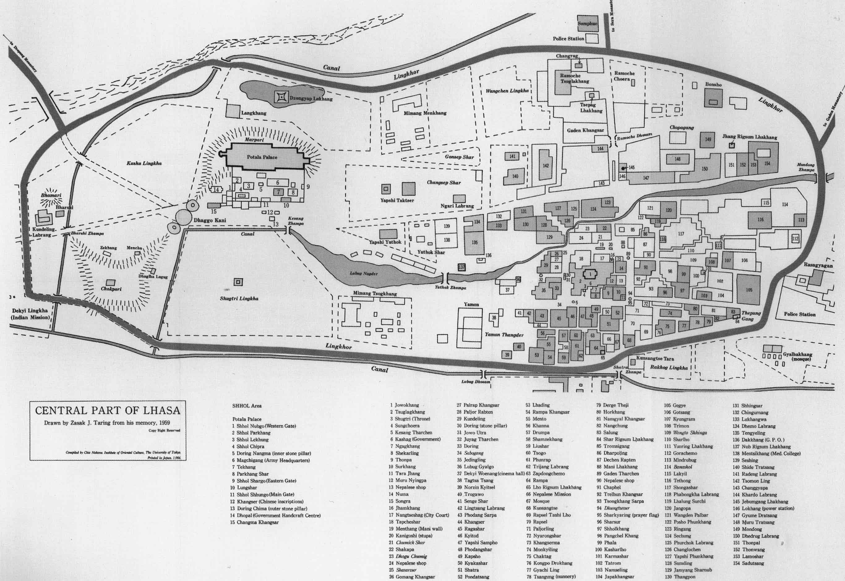
Lhasa has many sites of historic interest, including the Potala Palace, Jokhang Temple, Sera Monastery and Norbulingka. The Potala Palace, Jokhang Temple and the Norbulingka are UNESCO world heritage sites.[25] However, many important sites were damaged or destroyed mostly, but not solely, during the Cultural Revolution.[26][27][28] Many have been restored since the 1980s.
Culture
This section needs expansion. You can help by adding to it. (October 2010) |
Literature

There are some night spots which feature cabaret acts in which performers sing in English, Chinese, Tibetan, and Nepalese songs and dancers wear traditional Tibetan costume with long flowing cloth extending from their arms. There are a number of small bars which feature live music, although they typically have limited drink menus and cater mostly to foreign tourists.
Education
This section needs expansion. You can help by adding to it. (October 2010) |
Tibet University
.jpg)
Tibet University Tibet University is the main university of the Tibet Autonomous Region of China. It has two campuses: one in Lhasa and one in Nyingchi. A forerunner was created in 1952 and the university was officially established in 1985, funded by the Chinese government. About 7500 students are enrolled at the university.
Transport

The new Qingzang Railway which proceeds north and then east to Xining, some 2000 km, is the highest plateau railway in the world. Journalists report that the opening of the railway in July 2006 has brought with it an increasing demand for property which has pushed prices up.

Five trains arrive at and depart from Lhasa railway station each day. The destinations are Beijing West, Shanghai, Guangzhou, Chengdu, Chongqing; all trains travel via Xining and Lanzhou. and Initially the large altitude difference has caused problems on this route, giving passengers altitude sickness. To counter this, extra oxygen is pumped in through the ventilation system, and personal oxygen masks are available.[29]

Lhasa Gonggar Airport is located about one hour's taxi ride south from the city. There are flight connections to several Chinese cities including Beijing and Chengdu, and to Kathmandu in Nepal.
Highways
The Qinghai-Tibet Highway (part of G109) runs to northeast toward Xining and eventually to Beijing and is the mostly used road. The Sichuan-Tibet Highway (part of G318) runs east towards Chengdu and eventually to Shanghai. G318 also runs west toward Zhangmu on the Nepal border. The Xinjiang-Tibet Highway (G219) runs north to Yecheng, Xinjiang. This road is rarely used due to the lack of amenities and petrol stations.
Lhasa in entertainment
Life in Lhasa was covered by Austrian mountaineer Heinrich Harrer in his book Seven Years in Tibet [30] and the film of that same name which starred Brad Pitt and David Thewlis. The book in particular relates the story of Harrer's life in Lhasa during the 1940s and that of his companion Peter Aufschnaider. His autobiography, Beyond Seven Years in Tibet, published in English in 2007 also gives a perspective on his time in Lhasa.
Sister cities
Lhasa has four sister cities:[31]
 Boulder, Colorado, United States, since 1987
 Potosí, Bolivia, since 1995
 Elista, Kalmykia, Russia, since 2004
 Beit Shemesh, Israel, since 2007
Footnotes
- ^ Kolmaš, Josef. (1967) Tibet and Imperial China: A Survey of Sino-Tibetan Relations up to the end of the Manchu Dynasty in 1912, p. 7. Occasional paper 7. The Australian National University-Centre of Oriental Studies, Canberra.
- ^ Dorje (1999), pp. 68, 201-202.
- ^ Stein (1972), p. 38.
- ^ a b Dorje (1999), p. 68.
- ^ a b c Dorje (1999), p. 69.
- ^ Dowman (1988), p. 65.
- ^ Charles Bell (1992). Tibet Past and Present. CUP Motilal Banarsidass Publ. p. 28. ISBN 8120810481. Retrieved 2010-07-17.
{{cite book}}: More than one of|pages=and|page=specified (help) - ^ University of London. Contemporary China Institute, Congress for Cultural Freedom (1960). The China quarterly, Issue 1. p. 88. Retrieved 2010-07-17.
- ^ Roger E. McCarthy (1997). Tears of the lotus: accounts of Tibetan resistance to the Chinese invasion, 1950-1962. McFarland. p. 12. ISBN 0786403314. Retrieved 2010-07-17.
{{cite book}}: More than one of|pages=and|page=specified (help) - ^ Bloudeau, Anne-Mari & Gyatso, Yonten. 'Lhasa, Legend and History' in Lhasa in the Seventeenth Century: The Capital of the Dalai Lamas, 2003, pp. 24-25.
- ^ Bloudeau, Anne-Mari & Gyatso, Yonten. "Lhasa, Legend and History." In: Lhasa in the Seventeenth Century: The Capital of the Dalai Lamas. Françoise Pommaret-Imaeda, Françoise Pommaret 2003, p. 38. Brill, Netherlands. ISBN 9789004128668.
- ^ a b c d e LHASA. Online Encyclopedia. Search over 40,000 articles from the original, classic Encyclopedia Britannica, 11th Edition
- ^ Shail Mayaram (2009). The other global city. Taylor & Francis US. p. 60. ISBN 0415991943. Retrieved 2010-06-28.
- ^ Dowman (1988), p. 39.
- ^ Richardson (1984), p. 7.
- ^ Tung (1980), caption to plate 17, p. 42.
- ^ National Geographic Atlas of China (2007), p. 88. National Geographic, Washington, D.C. ISBN 978-1426201363.
- ^ National Geographic Atlas of China. (2008), p. 88. National Geographic, Washington D.C. ISBN 978-1-4262-0136-3.
- ^ a b Barnett, Robert (2006). Lhasa: streets with memories. Columbia University Press. p. 42. ISBN 0231136803.
- ^ Cite error: The named reference
CMAwas invoked but never defined (see the help page). - ^ Extreme Temperatures Around the world − world highest lowest temperatures. Accessed 2010-10-20
- ^ Miles, Paul (8 April 2005). "Tourism drive 'is destroying Tibet'". London: Telegraph. Retrieved 20 May 2009.
- ^ Lonely Planet
- ^ People's Government of Lhasa Official Website - "Administrative divisions"
- ^ "Historic Ensemble of the Potala Palace, Lhasa". unesco. Retrieved 2008-02-10. In the surrounding prefecture of Lhasa are Sera Monastery and its many hermitages, many of which overlook Lhasa from the northern hill valleys and Drepung Monastery, amongst many others of historical importance.
- ^ Bradley Mayhew and Michael Kohn. Tibet. 6th Edition (2005), pp. 36-37. Lonely Planet. ISBN 1-74059-523-8
- ^ Keith Dowman. The Power-Places of Central Tibet: The Pilgrim's Guide, (1988) pp. 8-13. Routledge & Kegan Paul, Ltd., London and New York. ISBN 0-7102-1370-0.
- ^ Laird, Thomas. (2006). The Story of Tibet: Conversations with the Dalai Lama, pp. 345-351.Grove Press, New York. ISBN 978-0-8021-1827-1.
- ^ Cody, Edward. "Train 27, Now Arriving Tibet, in a 'Great Leap West'". The Washington Post. Retrieved 2010-05-07.
- ^ Rediff.com
- ^ Lhasa city guide
References
- Das, Sarat Chandra. 1902. Lhasa and Central Tibet. Reprint: Mehra Offset Press, Delhi. 1988. ISBN 81-86230-17-3
- Dorje, Gyurme. 1999. Footprint Tibet Handbook. 2nd Edition. Bath, England. ISBN 1 900949 33 4. Also published in Chicago, U.S.A. ISBN 0 8442-2190-2.
- Dowman, Keith. 1988. The Power-Places of Central Tibet: The Pilgrim's Guide, p. 59. Routledge & Kegan Paul. London. ISBN 0-7102-1370-0 (ppk).
- Liu, Jianqiang (2006). chinadialogue - Preserving Lhasa's history (part one).
- Miles, Paul. (April 9, 2005). "Tourism drive 'is destroying Tibet' Unesco fears for Lhasa's World Heritage sites as the Chinese try to pull in 10 million visitors a year by 2020". Daily Telegraph (London), p. 4.
- Pelliot, Paul. (1961) Histoire ancienne du Tibet. Libraire d'Amérique et d'orient. Paris.
- Richardson, Hugh E (1984). Tibet and its History. Second Edition, Revised and Updated. Shambhala Publications, Boston. ISBN 0-87773-376-7.
- Richardson, Hugh E (1997). Lhasa. In Encyclopedia Americana international edition, (Vol. 17, pp. 281–282). Danbury, CT: Grolier Inc.
- Stein, R. A. (1972). Tibetan Civilization, p. 38. Reprint 1972. Stanford University Press. ISBN 0-8047-0806-1 (cloth); ISBN 0-8047-0901-7 (paper).
- Tung, Rosemary Jones. 1980. A Portrait of Lost Tibet. Thomas and Hudson, London. ISBN 0 500 54068 3.
- Vitali, Roberto. 1990. Early Temples of Central Tibet. Serindia Publications. London. ISBN 0-906026-25-3.
- (2006). Lhasa - Lhasa Intro
- von Schroeder, Ulrich. (1981). Indo-Tibetan Bronzes. (608 pages, 1244 illustrations). Hong Kong: Visual Dharma Publications Ltd. ISBN 962-7049-01-8
- von Schroeder, Ulrich. (2001). Buddhist Sculptures in Tibet. Vol. One: India & Nepal; Vol. Two: Tibet & China. (Volume One: 655 pages with 766 illustrations; Volume Two: 675 pages with 987 illustrations). Hong Kong: Visual Dharma Publications, Ltd.). ISBN 962-7049-07-7
- von Schroeder, Ulrich. 2008. 108 Buddhist Statues in Tibet. (212 p., 112 colour illustrations) (DVD with 527 digital photographs). Chicago: Serindia Publications. ISBN 962-7049-08-5
External links
{{{inline}}}
- People's Government of Lhasa Official Website Template:Zh icon
- Lhasa @ China Tibet Information Center
- Lhasa Nights art exhibition
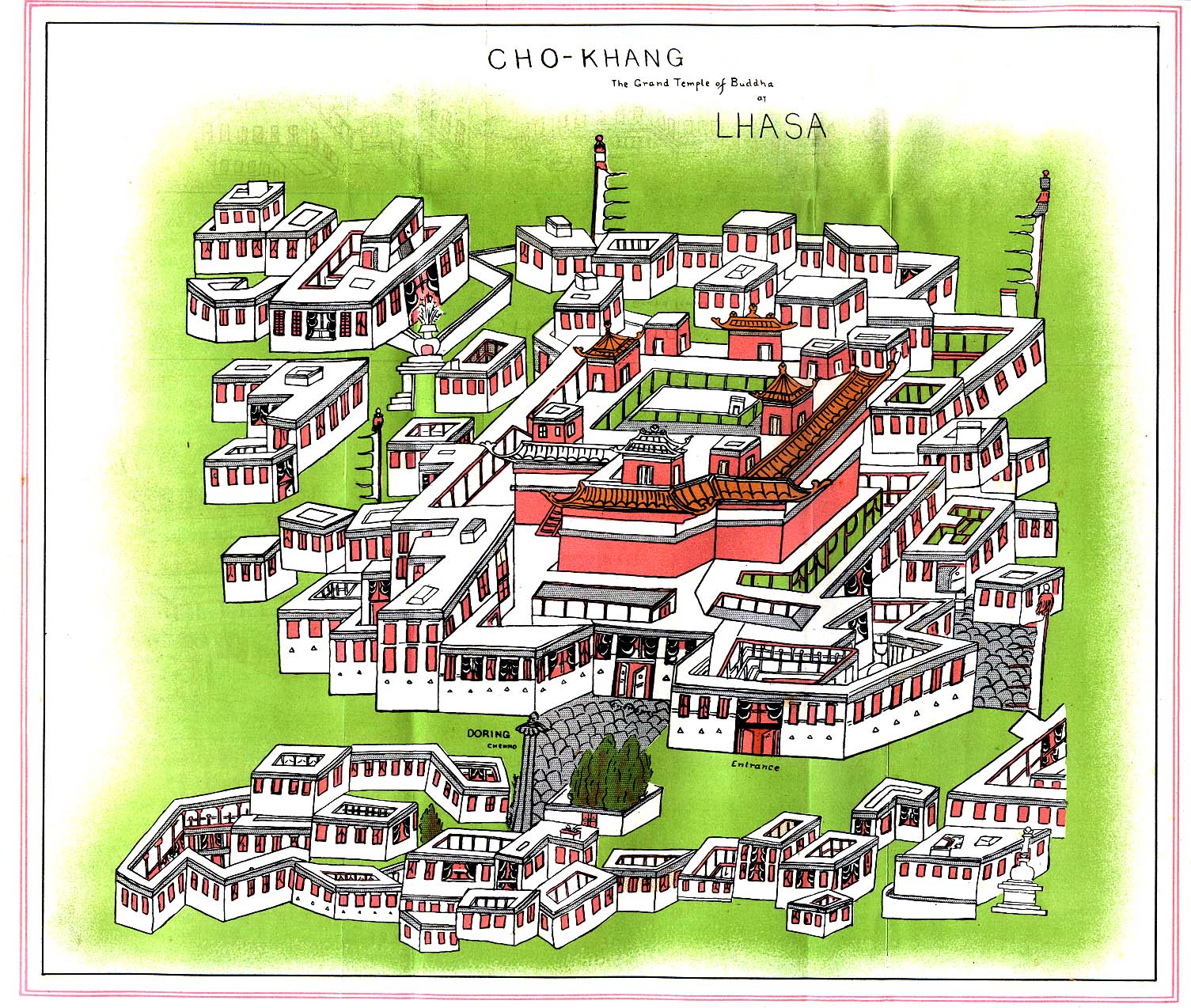
- Grand temple of Buddha at Lhasa in 1902, Perry-Castañeda Library Map Collection
Videos
- Short form of a video travelogue to Lhasa - the skyway over Sichuan-Tibet Highway to Lhasa, Potala Palace, Jokhang Temple, Serena Monastery, Tibet Train from Lhasa to Chengdu
Maps and aerial photos
29°39′N 91°06′E / 29.650°N 91.100°E
