Wujiaqu
This is an old revision of this page, as edited by Citation bot (talk | contribs) at 21:47, 18 April 2020 (Alter: url. Add: date. Removed parameters. Some additions/deletions were actually parameter name changes. | You can use this bot yourself. Report bugs here. | Activated by Amigao | Category:Populated places in Xinjiang | via #UCB_Category). The present address (URL) is a permanent link to this revision, which may differ significantly from the current revision.
Wujiaqu
五家渠市 ۋۇجياچۈ شەھىرى | |
|---|---|
 | |
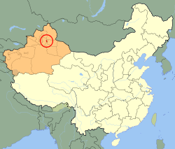
 Wujiaqu (red) in Xinjiang (orange) | |
| Coordinates: 44°10′01″N 87°32′35″E / 44.167°N 87.543°E / 44.167; 87.543 | |
| Country | People's Republic of China |
| Region | Xinjiang |
| Time zone | UTC+8 (China Standard) |
| Wujiaqu | |||||||||||
|---|---|---|---|---|---|---|---|---|---|---|---|
| Chinese name | |||||||||||
| Chinese | 五家渠 | ||||||||||
| |||||||||||
| Uyghur name | |||||||||||
| Uyghur | ۋۇجياچۈ | ||||||||||
| |||||||||||
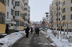
Wujiaqu is a sub-prefecture-level city in the northern part of Xinjiang Uyghur Autonomous Region, China, about 40 kilometres (25 mi) north of Ürümqi.
Demographics
As of 2015, 89,695 of the 93,058 residents of the city were Han Chinese, 1,926 were Hui and 1,437 were from other ethnic groups.[1]
Wujiaqu's population is around 96,000 and predominantly Han Chinese according to the 2010 census. There are also Hui and various other minorities.
- Population by ethnicity – 2010 census[2]
| Ethnicity | Population | % |
|---|---|---|
| Han | 92,372 | 95.79% |
| Hui | 2,541 | 2.63% |
| Mongols | 319 | 0.33% |
| Kazakhs | 232 | 0.24% |
| Uyghur | 223 | 0.23% |
| Tujia | 167 | 0.17% |
| Manchu | 128 | 0.13% |
| others | 454 | 0.47% |
| Total | 96,436 | 100% |
See also
| Current | |
|---|---|
| Under construction | |
| Approved | |
| Former | |
| |||||||||||||||||||||||||||||||||||||||||||||||||||||||||||||||
| |||||||||||||||||||||||||||||||||||||||||||||||||||||||||||||||
| |||||||||||||||||||||||||||||||||||||||||||||||||||||||||||||||
| |||||||||||||||||||||||||||||||||||||||||||||||||||||||||||||||
| |||||||||||||||||||||||||||||||||||||||||||||||||||||||||||||||
References
- ^ 3-7 各地、州、市、县(市)分民族人口数 (in Simplified Chinese). شىنجاڭ ئۇيغۇر ئاپتونوم رايونى 新疆维吾尔自治区统计局 Statistic Bureau of Xinjiang Uygur Autonomous Region. 15 March 2017. Archived from the original on 11 October 2017. Retrieved 3 September 2017.
- ^ Stanley W. Toops (August 2012). Eurasian Corridors of Interconnection: From the South China to the Caspian Sea. Routledge. pp. 65–66. ISBN 978-1135078751.
{{cite book}}: Unknown parameter|editors=ignored (|editor=suggested) (help)
- Pages using gadget WikiMiniAtlas
- Articles containing Uyghur-language text
- Articles containing Chinese-language text
- CS1 uses Chinese-language script (zh)
- CS1 Simplified Chinese-language sources (zh-hans)
- CS1 errors: unsupported parameter
- Articles with short description
- Short description is different from Wikidata
- Coordinates on Wikidata
- All stub articles

