
Pudong
Pudong New Area
| |
|---|---|
 Pudong skyline at night | |
 Location within Shanghai | |
| Country | |
| Municipality | Shanghai |
| District Gov't Established | 1993 |
| Government | |
| • CPC Pudong District Secretary | Xu Lin (徐麟) |
| • District Governor | Li Yiping (李逸平) |
| Area | |
| • Total | 1,210.4 km2 (467.3 sq mi) |
| Population (2010)[1] | |
| • Total | 5,044,430 |
| • Density | 4,200/km2 (11,000/sq mi) |
| Time zone | UTC+8 (China Standard Time) |
| Area Code | 021 |
| Postal Code | 200135 |
| Website | pudong.gov.cn |
| Pudong New Area | |||||||||||
|---|---|---|---|---|---|---|---|---|---|---|---|
| Simplified Chinese | 浦东新区 | ||||||||||
| Traditional Chinese | 浦東新區 | ||||||||||
| Wu | phu上ton平 sin平 chiu平 | ||||||||||
| |||||||||||
Pudong (Chinese: 浦东; pinyin: Pǔdōng, lit "Huangpu East Bank") is a state-level new area of Shanghai, China, located along the east side of the Huangpu River, across from the historic city center of Shanghai in Puxi. Formerly a little-developed agricultural area linked only by ferries, Pudong has grown rapidly since the 1990s and emerged as China's financial and commercial hub. [citation needed] It is principally administered as the Pudong New Area, a district of Shanghai.
Pudong is home to the Lujiazui Finance and Trade Zone and the Shanghai Stock Exchange and many of Shanghai's best-known buildings, such as the Oriental Pearl Tower, the Jin Mao Building, the Shanghai World Financial Center. It is also the site of the future Shanghai Tower. These modern skyscrapers face directly across from Puxi's historic Bund, the remnant of Shanghai's former concessions.
History
Pudong refers to the land in the east of Huangpu River. Originally, the area was mainly farmland and countryside with some warehouses and wharfs near the shore. The parts closest to Puxi were administered by its districts, including Huangpu, Yangpu, and the former Nanshi District. The rest of the area was administered by Chuansha County.
In 1993, the Chinese government decided to set up a Special Economic Zone in Chuansha, creating the Pudong New Area. The western tip of the Pudong district was designated as the Lujiazui Finance and Trade Zone and proposed to become the new financial hub of modern China. Several landmark buildings were constructed in Lujiazui to raise the image and awareness of the area. These include the Oriental Pearl Tower, the Jin Mao Building, and the supertall Shanghai World Financial Center. At 494 m, the last will be the tallest building in China until the completion of the nearby Shanghai Tower, projected to reach 565.6 m in 2014.
On May 6, 2009, it was disclosed that the State Council had approved the proposal to merge Nanhui District to Pudong. the Pudong New Area comprises the majority of land in eastern Shanghai.
Government
Districts of the direct-controlled municipality of Shanghai are administratively on the same level as prefecture-level cities. However, the government of Pudong has a status equivalent to that of a sub-provincial city, which is a half-level above a prefecture-level city. This is due to Pudong's size and importance as the financial hub of China.
Geography and Population
Pudong literally means "East Bank". Pudong is bounded by the Huangpu River in the west and the East China Sea in the east. Pudong is distinguished from Puxi ("West Bank"), the older part of Shanghai. It has an area of 1210.4 km² and according to the 2010 Census, a population of 5,044,430 inhabitants, 1.9 million more than in 2000. Currently, at least 2.1 million of residents of Pudong are newcomers from other provinces or cities in China.[2]
Education
University
Economy
This section needs additional citations for verification. (March 2010) |
This section needs expansion. You can help by adding to it. (August 2011) |
With the Nanhui District merger in May 2009, Pudong's new gross domestic product amounts to an estimated 370 billion RMB (US$53.98 billion), roughly equal to that of Slovenia. Its GDP per capita is therefore around US$16,938. The area's aggregate GDP has now surpassed that of six provincial-level entities.
The area is divided into four distinct economic districts. Apart from Lujiazui Trade and Finance Zone, there is Waigaoqiao Free Trade Zone, the largest free trade zone in mainland China covering approximately 10 km² in north-east Pudong. The Jinqiao Export Processing Zone is another major industrial area in Pudong covering 19 km². Zhangjiang Hi-tech Park is a special area for technology-oriented businesses, covering 17 km² in central Pudong.[citation needed]
The Pudong area continues to experience rapid development, especially in the commercial sector, with 1.3 million square meters of prime office space reaching completion in 2008, more than the previous two years combined.[3]
Pudong has also attracted considerable fixed asset and real estate investment, reporting 87.268 billion RMB in fixed asset investment and 27.997 billion RMB in real estate investment in 2008.[4]
The newest Disney Theme Park is now under construction in Pudong. It is planned to be operational by 2016.[5]
Hang Seng Bank has its mainland offices in the Hang Seng Bank Tower in Pudong.[6] Kroll has an office in the Hang Seng Bank Tower.[7]
Transportation
The Shanghai Pudong International Airport opened its doors in 1999, shortening the travel time for visitors.
In the same year, Line 2 of the Shanghai Metro commenced services. An extension brought the line further east, where it serves the airport. Other lines, namely Lines 4, 6, 7, 8, 9, 12 and 13 also have sections that serve parts of Pudong. A magnetic levitation train began operating in 2004, moving passengers between the airport and Longyang Road Metro station.

Pudong is connected to Puxi by several tunnels and four major bridges. The first of these bridges were the Nanpu Bridge (1991) and the Yangpu Bridge (1993). The Xupu Bridge opened in 1996. The latest of these is Lupu Bridge, which is the world's second longest arch bridge and was completed in 2002. Currently there are five tunnels that link the two sides, Dapu Rd. Tunnel, the first tunnel across the Huangpu River, Yan'an Rd. Tunnel, running east-west, and Dalian Rd. Tunnel, running north-south, Fuxing Rd. Tunnel, complementing the Yan'an Rd. Tunnel, Waihuan Tunnel, one part of Shanghai Outer Ring Express. Two new tunnels linking Lujiazui to Puxi are under construction.
Roads in Pudong have no particular longitudinal or latitudinal orientation. Major thoroughfares Pudong Avenue, Zhangyang Road and Yanggao Road run east-west until Yangpu Bridge before turning gradually to become north-south. Century Avenue crosses all three major roads and extends from Lujiazui to Century Park. Yanggao Road extends south to the A20, Shanghai's outer Ring road, which runs east-west from Xupu Bridge and then north-south beginning at the interchange near Renxi Village, when the east-west expressway turns into Yingbin Avenue, headed for Pudong International Airport.
Gallery
-
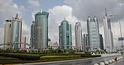
 Shanghai Pudong skyline
 -
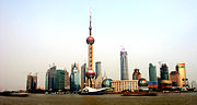
 Panoramic view at Shanghai Pudong (from the East)
 -
 Jin Mao building
 -
 Shanghai's Pudong skyline towers over the Huangpu River
 -
 Lujiazui Finance and Trade Zone, Pudong
 -
 Lujiazui skyline, Pudong
 -
 CITIC Pacific HQ & Mandarin Oriental
 -
Pudong at night (video)
-
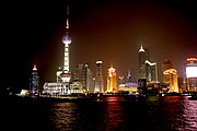
 Pudong at night with Oriental Pearl
 -
 Huangpu River at night. “Better City, Better Life” is the theme of Expo 2010.
 -
 A profile shot of Pudong
 -
 Pudong from Huangpu river cruise at night
 -
 View of Pudong area at night time
 -
 View of Pudong area, using HDR technique
 -
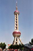 View of the Oriental Pearl Tower
 -


_046.jpg)

_033.jpg)


Twin towns — Sister cities
Pudong is twinned with:
See also
- Binhai New Area(Tianjin)
- Beijing CBD
- Central, Hong Kong
- Nishi-shinjuku (Tokyo)
- Bankenviertel (Frankfurt am Main)
- La Defense (Paris)
- City of London (London)
- Manhattan (New York)
- Singapore CBD
- Financial District (Toronto)
- Chicago Loop
References
- ^ Chinese Shanghai 2010 Census Data Eastday
- ^ Template:Zh icon China Statistical Office. Data from the Sixth National Population Census of the People's Republic of China
- ^ Knight Frank China Knight Frank China, Shanghai Commercial Market Quarterly Report, Q4 2009
- ^ Knight Frank China Knight Frank China, Shanghai Commercial Market Quarterly Report, Q1 2009
- ^ "[1]." THE WALT DISNEY COMPANY REACHES ANOTHER MAJOR MILESTONE ON SHANGHAI THEME PARK PROJECT. Retrieved on July 7, 2010.
- ^ "Mainland Service Network." Hang Seng Bank. Retrieved on 11 September 2011. "Hang Seng Bank(China)Limited Address: 34/F & 36/F, Hang Seng Bank Tower, 1000 Lujiazui Ring Road, Pudong, Shanghai, China"
- ^ "Office locations." Kroll Inc. Retrieved on 14 August 2011. "Shanghai Room 3031, 30F 1000 Lujiazui Ring Road, Hang Seng Bank Tower Pudong New Area Shanghai 200120 China"
- ^ "Kuopio and Shanghai Pudong have signed a sister city agreement". City of Kuopio. 2012-07-20. Retrieved 2012-08-24.
External links
| |||||||||||||||||||||||||||||||||||||||||||||||||||||||||||||||||||||||||||||||||||||||||||||